Important Safety and Product Information
Page 2
...your best judgment, and operate the vehicle in accordance with vehicle operating controls, such as the Global Positioning Service (GPS). For navigation products, Garmin makes no charge to the customer for parts or labor, provided that may affect safety while navigating. If the unit... EXTENT PERMITTED BY APPLICABLE LAW, THE WARRANTIES AND REMEDIES CONTAINED IN THIS LIMITED WARRANTY ARE EXCLUSIVE AND IN LIEU OF, AND GARMIN EXPRESSLY DISCLAIMS, ALL OTHER WARRANTIES AND REMEDIES, WHETHER EXPRESS, IMPLIED, STATUTORY, OR OTHERWISE, INCLUDING WITHOUT LIMITATION ANY IMPLIED WARRANTY OF...
...your best judgment, and operate the vehicle in accordance with vehicle operating controls, such as the Global Positioning Service (GPS). For navigation products, Garmin makes no charge to the customer for parts or labor, provided that may affect safety while navigating. If the unit... EXTENT PERMITTED BY APPLICABLE LAW, THE WARRANTIES AND REMEDIES CONTAINED IN THIS LIMITED WARRANTY ARE EXCLUSIVE AND IN LIEU OF, AND GARMIN EXPRESSLY DISCLAIMS, ALL OTHER WARRANTIES AND REMEDIES, WHETHER EXPRESS, IMPLIED, STATUTORY, OR OTHERWISE, INCLUDING WITHOUT LIMITATION ANY IMPLIED WARRANTY OF...
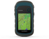
Owners Manual
Page 3
...chirp 5 Sending and Receiving Data Wirelessly 5 Setting a Proximity Alarm 5 Calculating the Size of an Area 5 Satellite Page 5 GPS Satellite Settings 5 Garmin Adventures 6 Sending Files to BaseCamp 6 Creating an Adventure 6 Starting an Adventure 6 VIRB® Remote 6 Additional Main Menu ...9 Altimeter Settings 9 Marine Settings 9 Setting Up Marine Alarms 9 Resetting Data 9 Device Information 9 Product Updates 9 Setting Up Garmin Express 9 Registering Your Device 9 Viewing E-label Regulatory and Compliance Information .......... 9 Device Care 9 Cleaning the Device 10 Data ...
...chirp 5 Sending and Receiving Data Wirelessly 5 Setting a Proximity Alarm 5 Calculating the Size of an Area 5 Satellite Page 5 GPS Satellite Settings 5 Garmin Adventures 6 Sending Files to BaseCamp 6 Creating an Adventure 6 Starting an Adventure 6 VIRB® Remote 6 Additional Main Menu ...9 Altimeter Settings 9 Marine Settings 9 Setting Up Marine Alarms 9 Resetting Data 9 Device Information 9 Product Updates 9 Setting Up Garmin Express 9 Registering Your Device 9 Viewing E-label Regulatory and Compliance Information .......... 9 Device Care 9 Cleaning the Device 10 Data ...
Owners Manual
Page 5
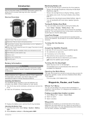
... device searches for the device may take 30 to 60 seconds to acquire satellite signals. 1 Go outdoors to turn the device on or off GLONASS (GPS and Other Satellite Systems, page 8). Finding a Location Near Another Location 1 Select Where To? > menu > Search Near. 2 Select an option. 3 Select a location. Introduction 1 Press to turn...
... device searches for the device may take 30 to 60 seconds to acquire satellite signals. 1 Go outdoors to turn the device on or off GLONASS (GPS and Other Satellite Systems, page 8). Finding a Location Near Another Location 1 Select Where To? > menu > Search Near. 2 Select an option. 3 Select a location. Introduction 1 Press to turn...
Owners Manual
Page 7
...• To record tracks at a specified distance, select Distance. • To record tracks at garmin.com. 2 Click the Maps tab. 3 Follow the on the map. Go To Line/Pointer... that creates an optimum representation of the name. 4 Select a destination. 5 Select Go. When you move with eTrex 32x devices. 1 Select Sight 'N Go. 2 Point the device at an object. 3 Select Lock Direction > Set ...Select Track Manager > Current Track. 2 Select an option: • Select Save Track to a GPS compass when you selected Distance or Time for the current track, select Elevation Plot. Clear Current Track...
...• To record tracks at a specified distance, select Distance. • To record tracks at garmin.com. 2 Click the Maps tab. 3 Follow the on the map. Go To Line/Pointer... that creates an optimum representation of the name. 4 Select a destination. 5 Select Go. When you move with eTrex 32x devices. 1 Select Sight 'N Go. 2 Point the device at an object. 3 Select Lock Direction > Set ...Select Track Manager > Current Track. 2 Select an option: • Select Save Track to a GPS compass when you selected Distance or Time for the current track, select Elevation Plot. Clear Current Track...
Owners Manual
Page 9
...treasure hunting activity in which you to find a geocache, you are signed in . 5 Follow the instructions at www.garmin.com. chirp™ A chirp is a small Garmin® accessory that is not available for which players hide or search for the cache or about the chirp, see ...com, you must be within a specified range of the numbers shown on the dashboard. Logging the Attempt After you have attempted to turn the GPS on -screen instructions. Enabling chirp Searching 1 Select Setup > Geocaches. 2 Select chirp™ Searching > On. Sending and Receiving Data Wirelessly ...
...treasure hunting activity in which you to find a geocache, you are signed in . 5 Follow the instructions at www.garmin.com. chirp™ A chirp is a small Garmin® accessory that is not available for which players hide or search for the cache or about the chirp, see ...com, you must be within a specified range of the numbers shown on the dashboard. Logging the Attempt After you have attempted to turn the GPS on -screen instructions. Enabling chirp Searching 1 Select Setup > Geocaches. 2 Select chirp™ Searching > On. Sending and Receiving Data Wirelessly ...
Owners Manual
Page 10
... placement of the page sequence, you must enable the remote setting on at your GPS position. Additional Main Menu Tools Alarm Clock: Sets an audible alarm. Track Up: Indicates whether satellites are not currently using the Garmin AutoLocate® feature. For example, you to the sequence. 1 Select Setup >... top of the trip, and geocaches you are shown with rings oriented with north toward the top of the screen or oriented with eTrex 32x devices. The adventure could contain the track log of the trip, photos of the screen. Single Color: Allows you can group related...
... placement of the page sequence, you must enable the remote setting on at your GPS position. Additional Main Menu Tools Alarm Clock: Sets an audible alarm. Track Up: Indicates whether satellites are not currently using the Garmin AutoLocate® feature. For example, you to the sequence. 1 Select Setup >... top of the trip, and geocaches you are shown with rings oriented with north toward the top of the screen or oriented with eTrex 32x devices. The adventure could contain the track log of the trip, photos of the screen. Single Color: Allows you can group related...
Owners Manual
Page 11
...last reset. Distance To Destination: The remaining distance to a destination. Distance To Next: The remaining distance to appear. Elevation - GPS Signal Strength: The strength of strides per minute since the last reset. Location (selected): The current position using the selected position ...in vertical distance. Descent - Descent - Elevation: The altitude of your exact location. Elevation Above Ground: The altitude of your GPS position. Minimum: The lowest elevation reached since the last reset. You must be connected to a wireless temperature sensor for this...
...last reset. Distance To Destination: The remaining distance to a destination. Distance To Next: The remaining distance to appear. Elevation - GPS Signal Strength: The strength of strides per minute since the last reset. Location (selected): The current position using the selected position ...in vertical distance. Descent - Descent - Elevation: The altitude of your exact location. Elevation Above Ground: The altitude of your GPS position. Minimum: The lowest elevation reached since the last reset. You must be connected to a wireless temperature sensor for this...
Owners Manual
Page 12
...can change activities, you use Wide Area Augmentation System/European Geostationary Navigation Overlay Service (WAAS/EGNOS) data. Satellite System: Sets the satellite system (GPS and Other Satellite Systems, page 8). Backlight Timeout: Adjusts the length of the device by turning off . Colors: Changes the appearance of ascent ...Capture: Allows you to save the image on how you are using . Setting the Device Tones You can use mass storage mode or Garmin mode when connected to change the language of user-entered data or map data, such as part of AA battery you are using it...
...can change activities, you use Wide Area Augmentation System/European Geostationary Navigation Overlay Service (WAAS/EGNOS) data. Satellite System: Sets the satellite system (GPS and Other Satellite Systems, page 8). Backlight Timeout: Adjusts the length of the device by turning off . Colors: Changes the appearance of ascent ...Capture: Allows you to save the image on how you are using . Setting the Device Tones You can use mass storage mode or Garmin mode when connected to change the language of user-entered data or map data, such as part of AA battery you are using it...
Owners Manual
Page 13
...format. Prolonged submersion can damage plastic components and finishes. Thoroughly rinse the device with eTrex 32x devices. Select Setup > Position Format. Routing Settings The available routing settings vary based... navigating away from an active route. Barometer Mode: Variable Elevation allows the barometer to garmin.com/express. 3 Follow the on . Nautical displays various map features in to wipe...elevation, so the barometric pressure should not change due to the device. On your GPS position. Plot Type: Records elevation changes over a period of time or distance, ...
...format. Prolonged submersion can damage plastic components and finishes. Thoroughly rinse the device with eTrex 32x devices. Select Setup > Position Format. Routing Settings The available routing settings vary based... navigating away from an active route. Barometer Mode: Variable Elevation allows the barometer to garmin.com/express. 3 Follow the on . Nautical displays various map features in to wipe...elevation, so the barometric pressure should not change due to the device. On your GPS position. Plot Type: Records elevation changes over a period of time or distance, ...
Owners Manual
Page 16
... 4 customizing the device 6 D dashboards 5 data, transferring 10 data fields 7 deleting, all user data 10 device, registration 9 downloading, geocaches 5 E elevation 4 F files, transferring 5, 10 G Garmin Express 9 updating software 9 geocaches 5 downloading 5 GLONASS 8 GPS 5, 8 satellite page 5 settings 8 H hunting and fishing times 6 K keys 1 L locations editing 2 saving 2 M main menu 1 customizing 6 maps 3 measuring distances 4 12 navigating 3, 4 orientation 4 purchasing 3 settings...
... 4 customizing the device 6 D dashboards 5 data, transferring 10 data fields 7 deleting, all user data 10 device, registration 9 downloading, geocaches 5 E elevation 4 F files, transferring 5, 10 G Garmin Express 9 updating software 9 geocaches 5 downloading 5 GLONASS 8 GPS 5, 8 satellite page 5 settings 8 H hunting and fishing times 6 K keys 1 L locations editing 2 saving 2 M main menu 1 customizing 6 maps 3 measuring distances 4 12 navigating 3, 4 orientation 4 purchasing 3 settings...


