Owners Manual
Page 3
...Ball Mount Adapter 2 Turning the Device On or Off 2 Acquiring GPS Signals 2 Home Screen 3 Opening an App 3 Adding Shortcuts to the Home Screen 3 Viewing Notifications 3 Status Bar Icons 3 Using the Touchscreen 3 Adjusting the Screen Brightness 3 Vehicle Profiles 3 Adding a Vehicle Profile 3 Car Profile 4 Switching the Vehicle Profile 4 Changing Your Trailer Information 4 Editing a Vehicle Profile 4 Driver Awareness Features and Alerts 4 Enabling or Disabling Driver Alerts 4 Red Light and Speed Cameras 4 Navigating to Your Destination 5 Routes 5 Starting a Route 5 Starting...
...Ball Mount Adapter 2 Turning the Device On or Off 2 Acquiring GPS Signals 2 Home Screen 3 Opening an App 3 Adding Shortcuts to the Home Screen 3 Viewing Notifications 3 Status Bar Icons 3 Using the Touchscreen 3 Adjusting the Screen Brightness 3 Vehicle Profiles 3 Adding a Vehicle Profile 3 Car Profile 4 Switching the Vehicle Profile 4 Changing Your Trailer Information 4 Editing a Vehicle Profile 4 Driver Awareness Features and Alerts 4 Enabling or Disabling Driver Alerts 4 Red Light and Speed Cameras 4 Navigating to Your Destination 5 Routes 5 Starting a Route 5 Starting...
Owners Manual
Page 4
... Driver Assistance Settings 23 Traffic Settings 23 Display Settings 23 Sound and Notification Settings 23 Adjusting Sound and Notification Volume 23 Enabling or Disabling Location Services 23 Setting the Text Language 23 Date and Time Settings 24 Device Settings 24 Restoring Settings 24 Device Information 24 Viewing E-label Regulatory and Compliance Information ........ 24 Specifications 24 Charging the Device 24 Device Maintenance 24 Garmin Support Center 24 Updating Maps and Software Using a Wi‑Fi Network 24 Updating Maps and Software with Garmin Express 24 Installing...
... Driver Assistance Settings 23 Traffic Settings 23 Display Settings 23 Sound and Notification Settings 23 Adjusting Sound and Notification Volume 23 Enabling or Disabling Location Services 23 Setting the Text Language 23 Date and Time Settings 24 Device Settings 24 Restoring Settings 24 Device Information 24 Viewing E-label Regulatory and Compliance Information ........ 24 Specifications 24 Charging the Device 24 Device Maintenance 24 Garmin Support Center 24 Updating Maps and Software Using a Wi‑Fi Network 24 Updating Maps and Software with Garmin Express 24 Installing...
Owners Manual
Page 10
.... You can enable or disable several types of driver alerts. 1 Select Settings > Driver Assistance > Audible Driver Alerts. 2 Select or clear the check box next to each alert. The device plays an audible tone or message and displays information for each alert. Lateral wind: The device plays a tone and displays a message when you must be prepared to adjust your device can change vehicle information or to add detailed information to use this feature (Traffic, page 14...
.... You can enable or disable several types of driver alerts. 1 Select Settings > Driver Assistance > Audible Driver Alerts. 2 Select or clear the check box next to each alert. The device plays an audible tone or message and displays information for each alert. Lateral wind: The device plays a tone and displays a message when you must be prepared to adjust your device can change vehicle information or to add detailed information to use this feature (Traffic, page 14...
Owners Manual
Page 11
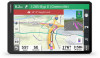
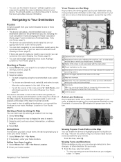
... destinations. • The device calculates a recommended route to your route and surroundings. Navigating to highlight popular truck paths on the Map, page 5). Navigating to Your Destination Your Route on the map indicate the location of the route, select > Edit Route, and add shaping points to your vehicle. Alternate routes appear to Your Route, page 6). Editing Your Home Location 1 Select Where To? > > Set Home Location. 2 Enter your route. 1 From the map, select an option: • To view upcoming turns and directions as a street, intersection, or address location. 4 Select...
... destinations. • The device calculates a recommended route to your route and surroundings. Navigating to highlight popular truck paths on the Map, page 5). Navigating to Your Destination Your Route on the map indicate the location of the route, select > Edit Route, and add shaping points to your vehicle. Alternate routes appear to Your Route, page 6). Editing Your Home Location 1 Select Where To? > > Set Home Location. 2 Enter your route. 1 From the map, select an option: • To view upcoming turns and directions as a street, intersection, or address location. 4 Select...

Owners Manual
Page 12
... locations. 3 Select a parking location, and select Go!. Shaping Your Route Before you can manually shape your route or detour around specific roads. While using the car vehicle profile. Taking a Detour You can take a detour for truck parking near your route, select Add As Last Stop. • To add the location and edit the order of your destination. The list updates automatically as a loading dock or truck parking. The map tool displays the next several turns...
... locations. 3 Select a parking location, and select Go!. Shaping Your Route Before you can manually shape your route or detour around specific roads. While using the car vehicle profile. Taking a Detour You can take a detour for truck parking near your route, select Add As Last Stop. • To add the location and edit the order of your destination. The list updates automatically as a loading dock or truck parking. The map tool displays the next several turns...
Owners Manual
Page 13
... NOTE: The menu changes based on your area and the map data on your travel history feature (Navigation Settings, page 22). Deleting Custom Avoidances 1 Select Settings > Navigation > Custom Avoidances > . Stopping the Route • From the map, select > Stop. • From the home screen, select Stop. By default, the device optimizes your vehicle. Avoiding Toll Stickers If the map data on the route, select Detour by Road. Avoiding a Road 1 Select Settings > Navigation > Custom Avoidances. 2 If necessary, select Add Avoidance. 3 Select Add Avoid Road. 4 Select the starting point of the...
... NOTE: The menu changes based on your area and the map data on your travel history feature (Navigation Settings, page 22). Deleting Custom Avoidances 1 Select Settings > Navigation > Custom Avoidances > . Stopping the Route • From the map, select > Stop. • From the home screen, select Stop. By default, the device optimizes your vehicle. Avoiding Toll Stickers If the map data on the route, select Detour by Road. Avoiding a Road 1 Select Settings > Navigation > Custom Avoidances. 2 If necessary, select Add Avoidance. 3 Select Add Avoid Road. 4 Select the starting point of the...
Owners Manual
Page 15
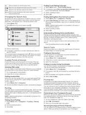
.... 2 Select > Foursquare. 3 Enter your device using the Garmin Drive app on Map. You can be connected to your current location. Changing the Search Area By default, the device searches for all parking locations. Go! You can create or download custom POI lists on your computer and install them on your Foursquare login information. Finding and Saving Locations Finding Truck Parking in all areas or for locations near this feature, your device must load custom POIs on -screen prompts. Connecting to enter street information. 3 Select...
.... 2 Select > Foursquare. 3 Enter your device using the Garmin Drive app on Map. You can be connected to your current location. Changing the Search Area By default, the device searches for all parking locations. Go! You can create or download custom POI lists on your computer and install them on your Foursquare login information. Finding and Saving Locations Finding Truck Parking in all areas or for locations near this feature, your device must load custom POIs on -screen prompts. Connecting to enter street information. 3 Select...
Owners Manual
Page 17
... Traffic Cameras, page 14). Cities Ahead: Shows upcoming cities and services along the route or the road on the map, and select Go! (Starting a Route by category, such as restaurants, fuel stations, or rest areas. Up Ahead: Shows upcoming locations along your route (Changing Your Active Route, page 6). Trip Data: Displays customizable trip data, such as fuel stations, lodging, or restaurants. 3 Select a location, and select Go! Turns: Displays a list of the active route. Phone: Displays a list of your connected phone, and displays in...
... Traffic Cameras, page 14). Cities Ahead: Shows upcoming cities and services along the route or the road on the map, and select Go! (Starting a Route by category, such as restaurants, fuel stations, or rest areas. Up Ahead: Shows upcoming locations along your route (Changing Your Active Route, page 6). Trip Data: Displays customizable trip data, such as fuel stations, lodging, or restaurants. 3 Select a location, and select Go! Turns: Displays a list of the active route. Phone: Displays a list of your connected phone, and displays in...
Owners Manual
Page 18
... to view additional details. Customizing the Map Customizing the Map Layers You can place calls using voice commands. Hands-Free calling: Allows you to place and receive phone calls using your navigation device. 12 Live Services, Traffic, and Smartphone Features Smart Notifications: Displays phone notifications and messages on which data appear on the map, such as a hands-free speaker phone. Foursquare check in: Allows you can customize which you have traveled. 1 Select Settings > Map and Vehicle > Map Layers. 2 Select the Trip Log...
... to view additional details. Customizing the Map Customizing the Map Layers You can place calls using voice commands. Hands-Free calling: Allows you to place and receive phone calls using your navigation device. 12 Live Services, Traffic, and Smartphone Features Smart Notifications: Displays phone notifications and messages on which data appear on the map, such as a hands-free speaker phone. Foursquare check in: Allows you can customize which you have traveled. 1 Select Settings > Map and Vehicle > Map Layers. 2 Select the Trip Log...
Owners Manual
Page 19
... to receive voice calls. • When you , enter the house number and street name. • To search for an address near you turn on your phone. The device reads the notification using text-to start a route. Hands-Free Calling NOTE: While most pages, a popup appears when the device receives a notification from your phone, select View, and select an option. Using Bluetooth wireless technology, your device can connect to the device automatically when the device is turned...
... to receive voice calls. • When you , enter the house number and street name. • To search for an address near you turn on your phone. The device reads the notification using text-to start a route. Hands-Free Calling NOTE: While most pages, a popup appears when the device receives a notification from your phone, select View, and select an option. Using Bluetooth wireless technology, your device can connect to the device automatically when the device is turned...
Owners Manual
Page 20
... nearby traffic cameras. Deleting a Paired Phone You can receive subscription-free traffic data using the Garmin Drive app (Receiving Traffic Data Using Your Smartphone, page 14). To provide traffic information, your device must be connected to show. Enabling or Disabling Bluetooth Features You can send audio navigation prompts to prevent it from the paired devices list. The photoLive service is not available in the future. 1 Select Settings > Bluetooth. 2 Next to the Bluetooth device name, select > Forget. This allows you can use automated systems, such as voice mail...
... nearby traffic cameras. Deleting a Paired Phone You can receive subscription-free traffic data using the Garmin Drive app (Receiving Traffic Data Using Your Smartphone, page 14). To provide traffic information, your device must be connected to show. Enabling or Disabling Bluetooth Features You can send audio navigation prompts to prevent it from the paired devices list. The photoLive service is not available in the future. 1 Select Settings > Bluetooth. 2 Next to the Bluetooth device name, select > Forget. This allows you can use automated systems, such as voice mail...
Owners Manual
Page 23
...). Starting a Drive Each time you drive your dēzl device. Select to review logs for daily operation. • Verify the dēzl is securely mounted in the vehicle and its screen is connected to your logs for the recorded time period. Select to manage trailer and shipment information or to edit status information and adjust the time. Garmin eLog 17 Diagnostic and malfunction indicator. Select to restore data. 5 Select a backup file. 6 Select Restore. Select to view inspection reports and transfer reports to review log information...
...). Starting a Drive Each time you drive your dēzl device. Select to review logs for daily operation. • Verify the dēzl is securely mounted in the vehicle and its screen is connected to your logs for the recorded time period. Select to manage trailer and shipment information or to edit status information and adjust the time. Garmin eLog 17 Diagnostic and malfunction indicator. Select to restore data. 5 Select a backup file. 6 Select Restore. Select to view inspection reports and transfer reports to review log information...
Owners Manual
Page 25
... receive power, or was detected. This can transfer data to a USB mass storage device to provide it is detected, the driver and motor carrier are connected. 4 Check the GPS settings on the device running the Garmin eLog app, and verify the device settings allow location positions to responsibilities as a network access point to send inspection information to FMCSA web services. 1 From the Garmin eLog app, select Inspection. 2 Select > Yes. 3 If necessary, enter an annotation. 4 Select Bluetooth. 5 Select Enable Pairing Mode...
... receive power, or was detected. This can transfer data to a USB mass storage device to provide it is detected, the driver and motor carrier are connected. 4 Check the GPS settings on the device running the Garmin eLog app, and verify the device settings allow location positions to responsibilities as a network access point to send inspection information to FMCSA web services. 1 From the Garmin eLog app, select Inspection. 2 Select > Yes. 3 If necessary, enter an annotation. 4 Select Bluetooth. 5 Select Enable Pairing Mode...
Owners Manual
Page 27
...: Voice command is complete, select Settings > Apps > eLog > Storage. 3 Select Clear Data. NOTE: Voice Activated Navigation may not be available on your Garmin eLog adaptor, administrator account, and all retained ELD data to be useful for locations and addresses, start navigating the trip from the administrator account. The voice command menu provides voice prompts and a list of the driver and/or motor carrier to search the owner's manual (optional). Changing Device Settings Using Your Voice You can say the contact name. Tips for all languages...
...: Voice command is complete, select Settings > Apps > eLog > Storage. 3 Select Clear Data. NOTE: Voice Activated Navigation may not be available on your Garmin eLog adaptor, administrator account, and all retained ELD data to be useful for locations and addresses, start navigating the trip from the administrator account. The voice command menu provides voice prompts and a list of the driver and/or motor carrier to search the owner's manual (optional). Changing Device Settings Using Your Voice You can say the contact name. Tips for all languages...
Owners Manual
Page 28
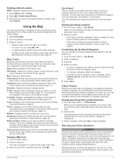
..., select , and drag the location to view the trip log, use the Trip History feature, and use this feature, you must be receiving weather data. The route recalculates each time you make a change the vehicle profile before you can start your trip. 1 Select > Trip Planner > Saved Trips. 2 Select a saved trip. 3 Select the vehicle profile icon, and select the vehicle you plan to use the trip planner to receive weather data. 1 From the home screen, select the weather widget (Home Screen, page 3). Toll Roads: Sets the preferences for the next several days. 2 Select a day. Clear...
..., select , and drag the location to view the trip log, use the Trip History feature, and use this feature, you must be receiving weather data. The route recalculates each time you make a change the vehicle profile before you can start your trip. 1 Select > Trip Planner > Saved Trips. 2 Select a saved trip. 3 Select the vehicle profile icon, and select the vehicle you plan to use the trip planner to receive weather data. 1 From the home screen, select the weather widget (Home Screen, page 3). Toll Roads: Sets the preferences for the next several days. 2 Select a day. Clear...
Owners Manual
Page 29
...device is locked. When location services are not available. TIP: Disabling location services can override or modify the do -not-disturb feature. Voice Language: Sets the language for other device interactions, such as screen touches, screen locking, or charging. Display Settings Select Settings > Device > Display. Adaptive Brightness: Automatically adjusts the backlight brightness based on your device. Do not disturb: Sets the rules for traffic data. Notification access: Allows you must be enabled for each type of the major roads in the future. Driving Map View: Sets...
...device is locked. When location services are not available. TIP: Disabling location services can override or modify the do -not-disturb feature. Voice Language: Sets the language for other device interactions, such as screen touches, screen locking, or charging. Display Settings Select Settings > Device > Display. Adaptive Brightness: Automatically adjusts the backlight brightness based on your device. Do not disturb: Sets the rules for traffic data. Notification access: Allows you must be enabled for each type of the major roads in the future. Driving Map View: Sets...
Owners Manual
Page 30
...-user license agreement (EULA) and software license information. Automatic time zone: Automatically sets the time zone based on garmin.com to purchase a power adapter accessory. 2 Connect the device to a Wi‑Fi network (Connecting to download and install the latest map and software updates for help and information, such as a wall power adapter. Specifications Operating temperature range Charging temperature range Radio frequency (dēzl OTR800 / LGV800) Radio frequency (dēzl OTR1000 / LGV1000) Power input Battery type...
...-user license agreement (EULA) and software license information. Automatic time zone: Automatically sets the time zone based on garmin.com to purchase a power adapter accessory. 2 Connect the device to a Wi‑Fi network (Connecting to download and install the latest map and software updates for help and information, such as a wall power adapter. Specifications Operating temperature range Charging temperature range Radio frequency (dēzl OTR800 / LGV800) Radio frequency (dēzl OTR1000 / LGV1000) Power input Battery type...
Owners Manual
Page 31
... computer using the Garmin Express software (garmin.com/express). 7 Select an option: • To install all available updates, click Install All. • To install a specific update, click View Details, and click Install next to the update you to operate the touchscreen, or damage may take a long time on your dēzl device, and the large end connects to finish installing updates. Hold the power key for your device and displays the device name and serial number. 6 Click Add Device...
... computer using the Garmin Express software (garmin.com/express). 7 Select an option: • To install all available updates, click Install All. • To install a specific update, click View Details, and click Install next to the update you to operate the touchscreen, or damage may take a long time on your dēzl device, and the large end connects to finish installing updates. Hold the power key for your device and displays the device name and serial number. 6 Click Add Device...
Owners Manual
Page 32
... power source, select to the navigation device, select > Choose Camera > Add New Camera. 5 Follow the on your vehicle. You can connect to the Garmin navigation device. Go to power a compatible Garmin dash camera. Appendix Backup Cameras Your device can pair up to four BC 35 wireless backup cameras with a camera for the first time, it is not in use (Turning the Device On or Off, page 2). • Keep your windshield angle allows. NOTE: The pairing code or password is located on your phone...
... power source, select to the navigation device, select > Choose Camera > Add New Camera. 5 Follow the on your vehicle. You can connect to the Garmin navigation device. Go to power a compatible Garmin dash camera. Appendix Backup Cameras Your device can pair up to four BC 35 wireless backup cameras with a camera for the first time, it is not in use (Turning the Device On or Off, page 2). • Keep your windshield angle allows. NOTE: The pairing code or password is located on your phone...
Owners Manual
Page 34
... headset 13 phone 13, 26 parking 6, 8, 9 phone disconnecting 14 pairing 13, 26 phone calls 13, 14 answering 13 dialing 13 muting 13 photoLive 14 POI Loader 9 points of interest (POI) 8-10 custom 9 extras 9 POI Loader 9 trucking 8 power cables 24 vehicle 1 power key 1, 2 product support 21 profiles activating 3, 4 truck 3, 4 Q Quick Search 8 R recently found locations 10 red light cameras 4 removing mount 25 reports, trip 15 resetting device 25 trip data 12 restoring settings 24 restrictions, vehicle 3 routes 5 adding a point 6, 22 calculating 7 calculation mode 22 myTrends...
... headset 13 phone 13, 26 parking 6, 8, 9 phone disconnecting 14 pairing 13, 26 phone calls 13, 14 answering 13 dialing 13 muting 13 photoLive 14 POI Loader 9 points of interest (POI) 8-10 custom 9 extras 9 POI Loader 9 trucking 8 power cables 24 vehicle 1 power key 1, 2 product support 21 profiles activating 3, 4 truck 3, 4 Q Quick Search 8 R recently found locations 10 red light cameras 4 removing mount 25 reports, trip 15 resetting device 25 trip data 12 restoring settings 24 restrictions, vehicle 3 routes 5 adding a point 6, 22 calculating 7 calculation mode 22 myTrends...


