Owners Manual
Page 3
... Getting Started 1 Connecting the Device to Vehicle Power 1 Acquiring GPS Signals 1 Status Bar Icons 1 Using the On-Screen Buttons 1 Entering and Exiting Sleep Mode 1 Turning Off the Device 1 Adjusting the Volume 1 Enabling Automatic Volume 1 Adjusting the Screen Brightness 1 Vehicle Profiles 2 Adding a Vehicle Profile 2 Activating a Vehicle Profile 2 Changing Your Trailer Information 2 Editing a Vehicle Profile 2 Navigating to Your Destination 2 Routes 2 Starting a Route 2 Going Home 2 Your Route on the Map 2 Active Lane Guidance 3 Viewing a List of Turns 3 Viewing the...
... Getting Started 1 Connecting the Device to Vehicle Power 1 Acquiring GPS Signals 1 Status Bar Icons 1 Using the On-Screen Buttons 1 Entering and Exiting Sleep Mode 1 Turning Off the Device 1 Adjusting the Volume 1 Enabling Automatic Volume 1 Adjusting the Screen Brightness 1 Vehicle Profiles 2 Adding a Vehicle Profile 2 Activating a Vehicle Profile 2 Changing Your Trailer Information 2 Editing a Vehicle Profile 2 Navigating to Your Destination 2 Routes 2 Starting a Route 2 Going Home 2 Your Route on the Map 2 Active Lane Guidance 3 Viewing a List of Turns 3 Viewing the...
Owners Manual
Page 4
... 17 Resetting the Device 17 Specifications 17 Appendix 17 Support and Updates 17 Setting Up Garmin Express 17 nüMaps Guarantee 18 Lifetime Subscriptions 18 Updating Maps and Software with Garmin Express 18 Data Management 18 File Types 18 About Memory Cards 18 Connecting the Device to Your Computer 18 Transferring Data From Your Computer 19 Viewing GPS Signal Status 19 Power Cables 19 Charging the Device 19 Changing the Fuse in the Vehicle Power Cable 19 Mounting on Your Dashboard 19 Removing the Device, Mount, and...
... 17 Resetting the Device 17 Specifications 17 Appendix 17 Support and Updates 17 Setting Up Garmin Express 17 nüMaps Guarantee 18 Lifetime Subscriptions 18 Updating Maps and Software with Garmin Express 18 Data Management 18 File Types 18 About Memory Cards 18 Connecting the Device to Your Computer 18 Transferring Data From Your Computer 19 Viewing GPS Signal Status 19 Power Cables 19 Charging the Device 19 Changing the Fuse in the Vehicle Power Cable 19 Mounting on Your Dashboard 19 Removing the Device, Mount, and...
Owners Manual
Page 5
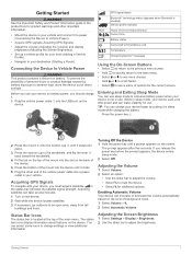
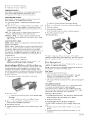
... Acquire GPS signals (Acquiring GPS Signals). • Adjust the volume (Adjusting the Volume) and display brightness (Adjusting the Screen Brightness). • Set up a vehicle profile for your truck (Adding a Vehicle Profile). • Navigate to change settings or view additional information. The prompt appears after five seconds. Enabling Automatic Volume Your device can select some icons to your destination (Starting a Route). Press the power key . À 2 Press the mount onto the suction cup until a prompt appears on the device. 2 Wait while the device locates satellites. 3 If...
... Acquire GPS signals (Acquiring GPS Signals). • Adjust the volume (Adjusting the Volume) and display brightness (Adjusting the Screen Brightness). • Set up a vehicle profile for your truck (Adding a Vehicle Profile). • Navigate to change settings or view additional information. The prompt appears after five seconds. Enabling Automatic Volume Your device can select some icons to your destination (Starting a Route). Press the power key . À 2 Press the mount onto the suction cup until a prompt appears on the device. 2 Wait while the device locates satellites. 3 If...
Owners Manual
Page 6
... activate a truck vehicle profile, the device avoids including restricted or impassable areas in all posted road signs and road conditions when making driving decisions. Navigating to Your Destination Routes A route is a path from the list. • To enter a new trailer configuration, select New Configuration, and enter the trailer information. 1 Select Settings > Vehicle Profile. 2 Select the vehicle profile to edit. 3 Select an option: • To edit the vehicle profile information, select , and select a field to a new vehicle profile, such as the vehicle identification number...
... activate a truck vehicle profile, the device avoids including restricted or impassable areas in all posted road signs and road conditions when making driving decisions. Navigating to Your Destination Routes A route is a path from the list. • To enter a new trailer configuration, select New Configuration, and enter the trailer information. 1 Select Settings > Vehicle Profile. 2 Select the vehicle profile to edit. 3 Select an option: • To edit the vehicle profile information, select , and select a field to a new vehicle profile, such as the vehicle identification number...

Owners Manual
Page 7
... your estimated arrival time appear at the bottom of your route. Stopping the Route From the map, select > Stop. This feature is useful if you approach a turn . Viewing the Entire Route on the Map 1 While navigating a route, select anywhere on the top of the map. 2 Select a turn appear. Your device re-calculates the route to include the added location and guides you to direct the route to use the trip planner to Your Destination 3 This allows...
... your estimated arrival time appear at the bottom of your route. Stopping the Route From the map, select > Stop. This feature is useful if you approach a turn . Viewing the Entire Route on the Map 1 While navigating a route, select anywhere on the top of the map. 2 Select a turn appear. Your device re-calculates the route to include the added location and guides you to direct the route to use the trip planner to Your Destination 3 This allows...

Owners Manual
Page 8
... in the trip. Editing and Saving Your Active Route If a route is the final location in a Trip The device can be useful for the trip, select the vehicle profile icon (Vehicle Profiles). • To add shaping points to enter the schedule information. TIP: If you need to create and save your trip. This can automatically optimize the order of the trip planner features. The starting point, and select Select. 4 Select Select Destination. 5 Select a location for your trip, select > Trip Settings > Shape Route, and follow the on-screen instructions to your starting location is...
... in the trip. Editing and Saving Your Active Route If a route is the final location in a Trip The device can be useful for the trip, select the vehicle profile icon (Vehicle Profiles). • To add shaping points to enter the schedule information. TIP: If you need to create and save your trip. This can automatically optimize the order of the trip planner features. The starting point, and select Select. 4 Select Select Destination. 5 Select a location for your trip, select > Trip Settings > Shape Route, and follow the on-screen instructions to your starting location is...
Owners Manual
Page 9
... features to the vehicle type in your device contain locations, such as restaurants, hotels, auto services, and detailed street information. Finding Locations 5 The selected area is not available in the traffic settings (Traffic Settings), you can view and avoid traffic delays manually. 1 While navigating a route, select > Traffic. 2 Select Alternate Route, if available. 3 Select Go!. The Where To? The map data on your device. • Select Toll Roads. • Select Tolls and Fees > Toll Roads. 3 Select an option: • To be calculated as you navigate, you can use...
... features to the vehicle type in your device contain locations, such as restaurants, hotels, auto services, and detailed street information. Finding Locations 5 The selected area is not available in the traffic settings (Traffic Settings), you can view and avoid traffic delays manually. 1 While navigating a route, select > Traffic. 2 Select Alternate Route, if available. 3 Select Go!. The Where To? The map data on your device. • Select Toll Roads. • Select Tolls and Fees > Toll Roads. 3 Select an option: • To be calculated as you navigate, you can use...
Owners Manual
Page 11
... Custom POIs are customized points on -screen instructions to view information about your current location. page to enter street information. 3 Select the intersection. NOTE: When a truck vehicle profile is active, an option for a city by responding to tell emergency personnel your current location is helpful if you disconnect the device from the list of interest. 3 Select > Check In. Finding an Intersection You can add shortcuts to the location, select Go! • To view the phone number and other roads. 1 Select...
... Custom POIs are customized points on -screen instructions to view information about your current location. page to enter street information. 3 Select the intersection. NOTE: When a truck vehicle profile is active, an option for a city by responding to tell emergency personnel your current location is helpful if you disconnect the device from the list of interest. 3 Select > Check In. Finding an Intersection You can add shortcuts to the location, select Go! • To view the phone number and other roads. 1 Select...

Owners Manual
Page 12
... and services along your home location for a location (Finding a Location by category. Map Tools Map tools provide quick access to add. 3 Select Save. You can view traffic information, take a detour, or adjust the screen brightness without leaving the map. For example, you return to most commonly used to pan left, right, up to confirm. 4 Select Save. Saving Your Current Location 1 From the map, select the vehicle icon. 2 Select Save. 3 Enter a name, and select Done. 4 Select OK. Saving a Home Location You can set your route or the road on a map. 7 Edit the information. 8 Select...
... and services along your home location for a location (Finding a Location by category. Map Tools Map tools provide quick access to add. 3 Select Save. You can view traffic information, take a detour, or adjust the screen brightness without leaving the map. For example, you return to most commonly used to pan left, right, up to confirm. 4 Select Save. Saving Your Current Location 1 From the map, select the vehicle icon. 2 Select Save. 3 Enter a name, and select Done. 4 Select OK. Saving a Home Location You can set your route or the road on a map. 7 Edit the information. 8 Select...
Owners Manual
Page 14
...; Select 3-D to the device. Traffic information may not be included with your device acquires satellite signals while receiving traffic signals from the pay service provider. 10 Traffic NOTE: This feature is not available for all models. • Traffic alerts appear on the map, and select Save. You can receive traffic data using a custom point of interest or a safety camera database. Before you can update safety cameras for an existing safety camera subscription by going to purchase a subscription or one-time update...
...; Select 3-D to the device. Traffic information may not be included with your device acquires satellite signals while receiving traffic signals from the pay service provider. 10 Traffic NOTE: This feature is not available for all models. • Traffic alerts appear on the map, and select Save. You can receive traffic data using a custom point of interest or a safety camera database. Before you can update safety cameras for an existing safety camera subscription by going to purchase a subscription or one-time update...
Owners Manual
Page 16
...8226; To edit the shipment information, select a field. • To delete the shipments, select > Delete Shipment > OK. Managing Shipments NOTE: This feature is not available in the category are transporting. 5 If necessary, select Start Day. 6 If necessary, select End Day. 7 Select Save. Logging Service History You can add custom categories (Adding Service Categories). 1 Select Apps > Service History. 2 Select a service category. 3 Select Add Record. 4 Enter the odometer reading, and select Next. 5 Enter a comment (optional). 6 Select Done. Your device memory contains important...
...8226; To edit the shipment information, select a field. • To delete the shipments, select > Delete Shipment > OK. Managing Shipments NOTE: This feature is not available in the category are transporting. 5 If necessary, select Start Day. 6 If necessary, select End Day. 7 Select Save. Logging Service History You can add custom categories (Adding Service Categories). 1 Select Apps > Service History. 2 Select a service category. 3 Select Add Record. 4 Enter the odometer reading, and select Next. 5 Enter a comment (optional). 6 Select Done. Your device memory contains important...
Owners Manual
Page 17
... using your device, you need to set the phone to your phone data connection. Select Apps > Phone > Call Home. Smartphone Link Smartphone Link is loaded from automatically connecting to use automated systems, such as voice mail. • To mute the microphone, select . • To hang up, select . Hands-Free Calling 13 Pairing Your Phone 1 Place your phone and your device in the future. 1 Select Settings > Bluetooth. 2 Select the phone, and select Unpair device. Placing a Call Dialing a Number 1 Select Apps > Phone > Dial. 2 Enter the number. 3 Select Dial. Receiving...
... using your device, you need to set the phone to your phone data connection. Select Apps > Phone > Call Home. Smartphone Link Smartphone Link is loaded from automatically connecting to use automated systems, such as voice mail. • To mute the microphone, select . • To hang up, select . Hands-Free Calling 13 Pairing Your Phone 1 Place your phone and your device in the future. 1 Select Settings > Bluetooth. 2 Select the phone, and select Unpair device. Placing a Call Dialing a Number 1 Select Apps > Phone > Dial. 2 Enter the number. 3 Select Dial. Receiving...
Owners Manual
Page 18
...use ecoRoute™ features, you must be connected to Garmin Live Services, you must download and install the Smartphone Link application on your phone. 1 Start Smartphone Link on your phone. 2 From your device, select Settings > Bluetooth. 3 Select the Bluetooth check box. 4 From your phone, enable Bluetooth wireless technology, and scan for nearby Bluetooth devices. Go to Add. 3 Select a road. 4 Select an intersection. 5 Select Save. See your phone owner's manual for compatibility and availability information. Saving a Traffic Camera Before you can receive real-time vehicle...
...use ecoRoute™ features, you must be connected to Garmin Live Services, you must download and install the Smartphone Link application on your phone. 1 Start Smartphone Link on your phone. 2 From your device, select Settings > Bluetooth. 3 Select the Bluetooth check box. 4 From your phone, enable Bluetooth wireless technology, and scan for nearby Bluetooth devices. Go to Add. 3 Select a road. 4 Select an intersection. 5 Select Save. See your phone owner's manual for compatibility and availability information. Saving a Traffic Camera Before you can receive real-time vehicle...
Owners Manual
Page 19
... feature is not available in the list. • To add a favorite city, select Add City, and enter a city name. The full message appears. You can view an animated, color-coded radar map of the graph to zoom in the Reports folder on your vehicle at high speeds on the device. Viewing Weather Alerts Before you can use this feature, you must purchase Advanced Weather service using Smartphone Link. Calibrating the...
... feature is not available in the list. • To add a favorite city, select Add City, and enter a city name. The full message appears. You can view an animated, color-coded radar map of the graph to zoom in the Reports folder on your vehicle at high speeds on the device. Viewing Weather Alerts Before you can use this feature, you must purchase Advanced Weather service using Smartphone Link. Calibrating the...
Owners Manual
Page 20
... the device from your location to your device. The route calculation is not available in the Screenshot folder of the device storage. Off Road: Calculates a direct line from receiving a GPS signal, and saves battery power. Setting a Simulated Location If you to take more icons. Traffic Alerts: Selects the traffic delay severity for more time to drive but can use this feature, you can be longer in distance. Checking Road Conditions Before you can use this feature, you to enter...
... the device from your location to your device. The route calculation is not available in the Screenshot folder of the device storage. Off Road: Calculates a direct line from receiving a GPS signal, and saves battery power. Setting a Simulated Location If you to take more icons. Traffic Alerts: Selects the traffic delay severity for more time to drive but can use this feature, you can be longer in distance. Checking Road Conditions Before you can use this feature, you to enter...
Owners Manual
Page 21
.... Keyboard Language: Enables keyboard languages. About: Displays the software version number, the unit ID number, and information on -screen text to water. Restoring Settings You can reset your device if it can damage plastic components. 1 Clean the outer casing of proximity points for distances. depending on usage and settings Battery type Rechargeable Lithium-ion Appendix Support and Updates Garmin Express™ provides easy access to 45°C) range Power input Vehicle power using GPS information, select Automatic. • To set the time manually...
.... Keyboard Language: Enables keyboard languages. About: Displays the software version number, the unit ID number, and information on -screen text to water. Restoring Settings You can reset your device if it can damage plastic components. 1 Clean the outer casing of proximity points for distances. depending on usage and settings Battery type Rechargeable Lithium-ion Appendix Support and Updates Garmin Express™ provides easy access to 45°C) range Power input Vehicle power using GPS information, select Automatic. • To set the time manually...
Owners Manual
Page 22
...-D: This model includes a nüMaps Lifetime subscription, lifetime digital traffic subscription, and a digital traffic receiver. A list of the USB cable into the slot on your computer. About Memory Cards You can store files on your computer using a USB cable. 18 The Garmin Express software detects your device. 2 Go to www.garmin.com/express. 3 Follow the on -screen instructions. nüMaps Guarantee™ Your device may take a long time on -screen instructions to complete the installation. 4 Start Garmin Express. 5 Connect your Garmin device to...
...-D: This model includes a nüMaps Lifetime subscription, lifetime digital traffic subscription, and a digital traffic receiver. A list of the USB cable into the slot on your computer. About Memory Cards You can store files on your computer using a USB cable. 18 The Garmin Express software detects your device. 2 Go to www.garmin.com/express. 3 Follow the on -screen instructions. nüMaps Guarantee™ Your device may take a long time on -screen instructions to complete the installation. 4 Start Garmin Express. 5 Connect your Garmin device to...
Owners Manual
Page 23
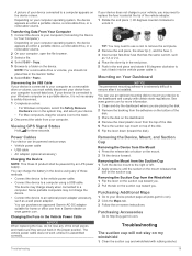
... need to a computer using a USB cable. Changing the Fuse in the proper position. Troubleshooting The suction cup will not stay on the device. Transferring Data From Your Computer 1 Connect the device to your device does not charge in the Garmin folder. 6 Select Edit > Paste. If your computer (Connecting the Device to http://buy.garmin.com. If your device is connected to your computer as either a portable device, a removable drive, or a removable volume. 2 On your vehicle, you . Power Cables Your device...
... need to a computer using a USB cable. Changing the Fuse in the proper position. Troubleshooting The suction cup will not stay on the device. Transferring Data From Your Computer 1 Connect the device to your device does not charge in the Garmin folder. 6 Select Edit > Paste. If your computer (Connecting the Device to http://buy.garmin.com. If your device is connected to your computer as either a portable device, a removable drive, or a removable volume. 2 On your vehicle, you . Power Cables Your device...
Owners Manual
Page 25
... voice 17 latitude and longitude 7 lifetime maps 18 locations 7, 16 calling 13 current 7, 8 recently found 7 saving 8 searching for 5, 7 setting home 8 simulated 16 venues 6 logs, driving 12 M map, tools 8 map layers, customizing 10 map view 2-D 10 3-D 10 maps 3, 8, 9, 16 data field 2, 9, 10 detail level 16 layers 10 lifetime 18 nüMaps Guarantee 18 nüMaps Lifetime 18 purchasing 19 symbols 2 theme 16 truck 9 updating 17, 18 viewing routes 2, 3 memory card 18 microSD card, installing 18 mileage reports 15 mount, removing 19 mounting...
... voice 17 latitude and longitude 7 lifetime maps 18 locations 7, 16 calling 13 current 7, 8 recently found 7 saving 8 searching for 5, 7 setting home 8 simulated 16 venues 6 logs, driving 12 M map, tools 8 map layers, customizing 10 map view 2-D 10 3-D 10 maps 3, 8, 9, 16 data field 2, 9, 10 detail level 16 layers 10 lifetime 18 nüMaps Guarantee 18 nüMaps Lifetime 18 purchasing 19 symbols 2 theme 16 truck 9 updating 17, 18 viewing routes 2, 3 memory card 18 microSD card, installing 18 mileage reports 15 mount, removing 19 mounting...
Owners Manual
Page 26
... 9 lifetime subscriptions 18 map 9 receiver 10 searching for delays 9 traffic cameras 14 viewing 14 travel history 17 trip information 9 resetting 9 viewing 9 trip log, viewing 9 trip planner 4 editing a trip 4 shaping points 4 troubleshooting 19, 20 truck drivers 12 map 9 points of interest 6 profiles 2 shipments 12 trailer 2 turn list 3 U unit ID 17 up ahead customizing 9 finding services 8 updating maps 18 software 18 USB, disconnecting 19 V vehicle power cable 1 vehicle profile 14 truck 2 venues 6 volume, adjusting 1 W warning icons 9, 10 weather 15 radar 15 road conditions 16 Where Am...
... 9 lifetime subscriptions 18 map 9 receiver 10 searching for delays 9 traffic cameras 14 viewing 14 travel history 17 trip information 9 resetting 9 viewing 9 trip log, viewing 9 trip planner 4 editing a trip 4 shaping points 4 troubleshooting 19, 20 truck drivers 12 map 9 points of interest 6 profiles 2 shipments 12 trailer 2 turn list 3 U unit ID 17 up ahead customizing 9 finding services 8 updating maps 18 software 18 USB, disconnecting 19 V vehicle power cable 1 vehicle profile 14 truck 2 venues 6 volume, adjusting 1 W warning icons 9, 10 weather 15 radar 15 road conditions 16 Where Am...


