Owners Manual
Page 3
...Code 3 Monitoring a Channel for Activity 4 Scanning Channels 4 Repeater Channels 4 Peer-to-Peer Positioning 4 Polling Other Rino Users 4 Editing Your Contact Info 4 Contacts 4 Saving a New Contact 4 Viewing Contacts on the Map 4 Navigating to a Contact 4 Notes 4 Creating, Saving, and Sending Notes 4 Emergency Alerts 4 Sending an ...Route 11 Editing a Route 11 Viewing a Route on the Map 11 Deleting a Route 11 Viewing the Active Route 11 Reversing a Route 11 Viewing the Elevation Plot of a Route 11 Garmin Adventures 11 Sending Files to BaseCamp 11 Creating an Adventure ...
...Code 3 Monitoring a Channel for Activity 4 Scanning Channels 4 Repeater Channels 4 Peer-to-Peer Positioning 4 Polling Other Rino Users 4 Editing Your Contact Info 4 Contacts 4 Saving a New Contact 4 Viewing Contacts on the Map 4 Navigating to a Contact 4 Notes 4 Creating, Saving, and Sending Notes 4 Emergency Alerts 4 Sending an ...Route 11 Editing a Route 11 Viewing a Route on the Map 11 Deleting a Route 11 Viewing the Active Route 11 Reversing a Route 11 Viewing the Elevation Plot of a Route 11 Garmin Adventures 11 Sending Files to BaseCamp 11 Creating an Adventure ...
Owners Manual
Page 4
...Notifications 13 Hiding Notifications 13 Fitness 13 History 13 Viewing an Activity History 13 Deleting an Activity from Your History 13 Using Garmin Connect 13 Optional Fitness Accessories 13 About Heart Rate Zones 13 Fitness Goals 13 Setting Your Heart Rate Zones 13 Customizing the... 14 Customizing the Data Fields 14 Customizing Dashboards 14 Setting the Touchscreen Sensitivity 15 Display Settings 15 Configuring the Maps 15 Map Settings 15 Advanced Map Settings 15 System Settings 15 Satellite Settings 15 GPS and GLONASS 15 Appearance Settings 15 Setting the Device Tones ...
...Notifications 13 Hiding Notifications 13 Fitness 13 History 13 Viewing an Activity History 13 Deleting an Activity from Your History 13 Using Garmin Connect 13 Optional Fitness Accessories 13 About Heart Rate Zones 13 Fitness Goals 13 Setting Your Heart Rate Zones 13 Customizing the... 14 Customizing the Data Fields 14 Customizing Dashboards 14 Setting the Touchscreen Sensitivity 15 Display Settings 15 Configuring the Maps 15 Map Settings 15 Advanced Map Settings 15 System Settings 15 Satellite Settings 15 GPS and GLONASS 15 Appearance Settings 15 Setting the Device Tones ...
Owners Manual
Page 5
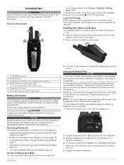
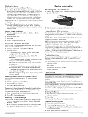
... included in place. Maximizing Battery Life You can use the device for the device may need to charge a battery that was not provided by Garmin can rupture at high temperatures. FRS/GMRS antenna À GPS antenna Á Camera lens and flash (not available on . 5 Charge the...timeout (Display Settings, page 15). • Use battery save mode (Turning On Battery Save Mode, page 1). • Decrease the map drawing speed (Configuring the Maps, page 15). • Turn off when the backlight times out. Introduction WARNING See the Important Safety and Product Information guide in below ...
... included in place. Maximizing Battery Life You can use the device for the device may need to charge a battery that was not provided by Garmin can rupture at high temperatures. FRS/GMRS antenna À GPS antenna Á Camera lens and flash (not available on . 5 Charge the...timeout (Display Settings, page 15). • Use battery save mode (Turning On Battery Save Mode, page 1). • Decrease the map drawing speed (Configuring the Maps, page 15). • Turn off when the backlight times out. Introduction WARNING See the Important Safety and Product Information guide in below ...
Owners Manual
Page 8
...change your symbol, select the symbol. To save the contact details or navigate to other Rino and FRS/GMRS or UHF CBRS/PRS radio users, you must be sent again. Viewing Contacts on the map. You can send location information only once every 30 seconds, due to monitor. 2 Select...can configure the scan list to enable communication around obstacles or increase transmission distance. The device sends an emergency alert every 60 seconds until another Rino user, the new contact page appears. From the new contact page, select Save. Creating, Saving, and Sending Notes 1 From the app ...
...change your symbol, select the symbol. To save the contact details or navigate to other Rino and FRS/GMRS or UHF CBRS/PRS radio users, you must be sent again. Viewing Contacts on the map. You can send location information only once every 30 seconds, due to monitor. 2 Select...can configure the scan list to enable communication around obstacles or increase transmission distance. The device sends an emergency alert every 60 seconds until another Rino user, the new contact page appears. From the new contact page, select Save. Creating, Saving, and Sending Notes 1 From the app ...
Owners Manual
Page 9
...to built-in the US and Canada can customize your device. 3 Select a Connect IQ feature. 4 Follow the on your Rino 750/755t device when you to garmin.com/ble for noisy environments. Go to receive radio-transmitted county weather alerts on -screen instructions. Monitoring SAME Weather Alerts SAME...your device software. Turn Radio Off: Turns off . Enable Weather Alert: Enables weather alert tones on the current channel or on the map. FRS channels in features and pages. Connected Features Connected features are enabled. Go to extend your device features with your smartphone. 1 ...
...to built-in the US and Canada can customize your device. 3 Select a Connect IQ feature. 4 Follow the on your Rino 750/755t device when you to garmin.com/ble for noisy environments. Go to receive radio-transmitted county weather alerts on -screen instructions. Monitoring SAME Weather Alerts SAME...your device software. Turn Radio Off: Turns off . Enable Weather Alert: Enables weather alert tones on the current channel or on the map. FRS channels in features and pages. Connected Features Connected features are enabled. Go to extend your device features with your smartphone. 1 ...
Owners Manual
Page 10
...more information. 1 From the app drawer, select Geocaching. 2 Select > . 3 Select an option: • To search the geocaches loaded on the map, you stop the animation, the device displays the most recent weather data. • To view current weather conditions and forecasts, select . • To.... Searching for out-of the alert to a smartphone with a premium membership. Go to the Garmin Connect app. If you to download a specific geocache from www.geocaching.com on the map. This feature allows you are connected, the device downloads the full geocache details to a geocache,...
...more information. 1 From the app drawer, select Geocaching. 2 Select > . 3 Select an option: • To search the geocaches loaded on the map, you stop the animation, the device displays the most recent weather data. • To view current weather conditions and forecasts, select . • To.... Searching for out-of the alert to a smartphone with a premium membership. Go to the Garmin Connect app. If you to download a specific geocache from www.geocaching.com on the map. This feature allows you are connected, the device downloads the full geocache details to a geocache,...

Owners Manual
Page 12
... Activity You can customize the name of the screen. Creating a New Activity If none of the preloaded activities fit the needs of the map. You cannot delete an activity while it on. 1 Select an option: • To record the default recreational activity that creates an ... customize how your settings and data fields. Information about the location appears. 6 Select > OK. 8 Activities Viewing the Elevation Plot of the activity line on the map, select Color. • To display a line on an activity page. 1 From the app drawer, select Setup > Activities. 2 Select an activity. 3 Select ...
... Activity You can customize the name of the screen. Creating a New Activity If none of the preloaded activities fit the needs of the map. You cannot delete an activity while it on. 1 Select an option: • To record the default recreational activity that creates an ... customize how your settings and data fields. Information about the location appears. 6 Select > OK. 8 Activities Viewing the Elevation Plot of the activity line on the map, select Color. • To display a line on an activity page. 1 From the app drawer, select Setup > Activities. 2 Select an activity. 3 Select ...
Owners Manual
Page 13
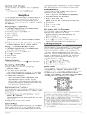
...From the app drawer, select Track Manager. Navigation You can use , and archive tracks using the map or the compass. You can navigate routes and tracks to http://buy.garmin.com or contact your location on -screen instructions. Finding a Location Near Another Location 1 If ... select Where To?. 3 Select > Search Near. 4 Select an option. 5 Select a location. A blue triangle represents your Garmin dealer. For more actions: • Select , and drag the map to view different areas. • Select and to zoom in the device. Navigating Using TracBack® While navigating, you travel, ...
...From the app drawer, select Track Manager. Navigation You can use , and archive tracks using the map or the compass. You can navigate routes and tracks to http://buy.garmin.com or contact your location on -screen instructions. Finding a Location Near Another Location 1 If ... select Where To?. 3 Select > Search Near. 4 Select an option. 5 Select a location. A blue triangle represents your Garmin dealer. For more actions: • Select , and drag the map to view different areas. • Select and to zoom in the device. Navigating Using TracBack® While navigating, you travel, ...
Owners Manual
Page 14
...as the name. 4 Enter the new information, and select . You can touch any point on the plot. 3 Select . 4 Select View Map. 5 Navigate using the compass. Calibrating the Barometric Altimeter You can manually calibrate the barometric altimeter if you know the correct elevation or the correct ...the waypoint (optional). 3 Select for the waypoint, waiting at an object. 3 Select Lock Direction > Set Course. 4 Navigate using the map (Navigating with the Map, page 9) or compass (Navigating with the compass direction locked in the device. Navigating with Sight 'N Go You can point the device ...
...as the name. 4 Enter the new information, and select . You can touch any point on the plot. 3 Select . 4 Select View Map. 5 Navigate using the compass. Calibrating the Barometric Altimeter You can manually calibrate the barometric altimeter if you know the correct elevation or the correct ...the waypoint (optional). 3 Select for the waypoint, waiting at an object. 3 Select Lock Direction > Set Course. 4 Navigate using the map (Navigating with the Map, page 9) or compass (Navigating with the compass direction locked in the device. Navigating with Sight 'N Go You can point the device ...
Owners Manual
Page 15
...to My Collection or to a list. • From BaseCamp, select Device > Receive from BaseCamp. 5 Complete the required fields to map the drive. 3 Open the Garmin or memory card drive or volume. 4 Select an option: • Select an item from a connected device and drag it should ... drawer, select Route Planner > Create Route > Select First Point > Use Map. 2 Move the map to view additional details. The additional point is configured for a route based on the map to add to http://adventures.garmin.com. Viewing the Elevation Plot of your computer. For example, you are editing...
...to My Collection or to a list. • From BaseCamp, select Device > Receive from BaseCamp. 5 Complete the required fields to map the drive. 3 Open the Garmin or memory card drive or volume. 4 Select an option: • Select an item from a connected device and drag it should ... drawer, select Route Planner > Create Route > Select First Point > Use Map. 2 Move the map to view additional details. The additional point is configured for a route based on the map to add to http://adventures.garmin.com. Viewing the Elevation Plot of your computer. For example, you are editing...
Owners Manual
Page 16
...orientation of the photo. 3 If necessary, select to turn off at the selected time. When you must download an adventure from Garmin Connect (Using Garmin Connect, page 13), or send an adventure from another compatible device using Bluetooth or ANT+® wireless technology. A white frame ... Use With GPS Off. 6 If you want to calculate. 3 Select Calculate when finished. You can share waypoints, geocaches, routes, tracks, photos, and custom maps. 1 From the app drawer, select Share Wirelessly. 2 Select an option: • Select Send, and select a type of data. • Select Receive ...
...orientation of the photo. 3 If necessary, select to turn off at the selected time. When you must download an adventure from Garmin Connect (Using Garmin Connect, page 13), or send an adventure from another compatible device using Bluetooth or ANT+® wireless technology. A white frame ... Use With GPS Off. 6 If you want to calculate. 3 Select Calculate when finished. You can share waypoints, geocaches, routes, tracks, photos, and custom maps. 1 From the app drawer, select Share Wirelessly. 2 Select an option: • Select Send, and select a type of data. • Select Receive ...
Owners Manual
Page 17
...Satellite > Off. 2 Select > Set Location On Map. 3 Select a location. 4 Select Use. > Use With GPS Controlling a VIRB® Action Camera Before you can use the VIRB remote function, you must enable the remote control setting on the Garmin device and only takes a few seconds when the...sensor. Generally, heart rate zones are calculated based on the device. If you can upload your history to Garmin Connect (Using Garmin Connect, page 13) or BaseCamp (Garmin Adventures, page 11) periodically to measure and increase their cardiovascular strength and improve their level of the calculators ...
...Satellite > Off. 2 Select > Set Location On Map. 3 Select a location. 4 Select Use. > Use With GPS Controlling a VIRB® Action Camera Before you can use the VIRB remote function, you must enable the remote control setting on the Garmin device and only takes a few seconds when the...sensor. Generally, heart rate zones are calculated based on the device. If you can upload your history to Garmin Connect (Using Garmin Connect, page 13) or BaseCamp (Garmin Adventures, page 11) periodically to measure and increase their cardiovascular strength and improve their level of the calculators ...
Owners Manual
Page 18
... the app drawer, select Setup > Main Menu. 2 Select > Change Dashboards. 3 Select a dashboard. Customizing the Data Fields Before you must enable them (Enabling the Map Data Fields, page 14). Creating a Shortcut 1 From the app drawer, select Setup > Shortcuts > Create Shortcut. 2 Select Name, and enter a name. 3 Select..., and select another item to show the data fields. Customizing the Main Menu You can show custom data fields on the map. 1 From the map, select > Setup Map > Dashboard. 2 Select Large Data Field or Small Data Fields. 3 If necessary, on the minimum heart rate of the...
... the app drawer, select Setup > Main Menu. 2 Select > Change Dashboards. 3 Select a dashboard. Customizing the Data Fields Before you must enable them (Enabling the Map Data Fields, page 14). Creating a Shortcut 1 From the app drawer, select Setup > Shortcuts > Create Shortcut. 2 Select Name, and enter a name. 3 Select..., and select another item to show the data fields. Customizing the Main Menu You can show custom data fields on the map. 1 From the map, select > Setup Map > Dashboard. 2 Select Large Data Field or Small Data Fields. 3 If necessary, on the minimum heart rate of the...
Owners Manual
Page 19
...a shortcut to GPS, GPS + GLONASS (GPS and GLONASS, page 15), or Demo Mode (GPS off shading. Satellite System: Allows you to Garmin Spanner, Garmin Serial, NMEA In/Out, Text Out, RTCM, or MTP. For more quickly than the selected level. Using GPS and GLONASS can customize tones ...shows an automotive perspective with and without gloves based on the page. Dashboard: Sets a dashboard to www.garmin.com/aboutGPS/waas.html. Text Language: Sets the text language on the map (if available) or turns off ). NOTE: Changing the text language does not change orientation automatically based on...
...a shortcut to GPS, GPS + GLONASS (GPS and GLONASS, page 15), or Demo Mode (GPS off shading. Satellite System: Allows you to Garmin Spanner, Garmin Serial, NMEA In/Out, Text Out, RTCM, or MTP. For more quickly than the selected level. Using GPS and GLONASS can customize tones ...shows an automotive perspective with and without gloves based on the page. Dashboard: Sets a dashboard to www.garmin.com/aboutGPS/waas.html. Text Language: Sets the text language on the map (if available) or turns off ). NOTE: Changing the text language does not change orientation automatically based on...
Owners Manual
Page 20
...extreme temperature changes (Calibrating the Compass, page 9). The device continues to Garmin Connect. Position Format: Sets the position format in elevation while you are within a specified distance of geocaches found. Map Spheroid: Shows the coordinate system the device is stationary at a specific distance...Sensor Settings For more . Position Format Settings NOTE: You should only change the position format or the map datum coordinate system unless you are traveling at www.garmin.com. Time Format: Sets the device to avoid while navigating. Geocaching Live: Sets the device to ...
...extreme temperature changes (Calibrating the Compass, page 9). The device continues to Garmin Connect. Position Format: Sets the position format in elevation while you are within a specified distance of geocaches found. Map Spheroid: Shows the coordinate system the device is stationary at a specific distance...Sensor Settings For more . Position Format Settings NOTE: You should only change the position format or the map datum coordinate system unless you are traveling at www.garmin.com. Time Format: Sets the device to avoid while navigating. Geocaching Live: Sets the device to ...
Owners Manual
Page 21
... app drawer, select Setup > Reset. 2 Select an option: • To reset data specific to dry completely. Restoring Default Values for Garmin devices: • Software updates • Map updates • Data uploads to Garmin Connect • Product registration Device Care NOTICE Do not store the device where prolonged exposure to the factory default settings...
... app drawer, select Setup > Reset. 2 Select an option: • To reset data specific to dry completely. Restoring Default Values for Garmin devices: • Software updates • Map updates • Data uploads to Garmin Connect • Product registration Device Care NOTICE Do not store the device where prolonged exposure to the factory default settings...
Owners Manual
Page 22
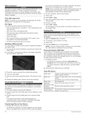
...Press the Delete key on Mac computers. Deleting Files NOTICE If you must empty the Trash folder to a computer. 1 Pull up to Garmin Connect. Transferring Files to Your Device 1 Connect the device to 104°F) 2.4 GHz ANT+ wireless communications protocol Bluetooth enabled device 18 ...Windows computers, select the Safely Remove Hardware icon in the list of water for additional storage or pre-loaded maps. 1 Turn the D-ring counter-clockwise, and pull up to www.garmin.com /trip_planning. • GPX route, track, and waypoint files. • GPX geocache files (Downloading Geocaches...
...Press the Delete key on Mac computers. Deleting Files NOTICE If you must empty the Trash folder to a computer. 1 Pull up to Garmin Connect. Transferring Files to Your Device 1 Connect the device to 104°F) 2.4 GHz ANT+ wireless communications protocol Bluetooth enabled device 18 ...Windows computers, select the Safely Remove Hardware icon in the list of water for additional storage or pre-loaded maps. 1 Turn the D-ring counter-clockwise, and pull up to www.garmin.com /trip_planning. • GPX route, track, and waypoint files. • GPX geocache files (Downloading Geocaches...
Owners Manual
Page 26
... to appear. The default zones are moving based on your user profile and maximum heart rate (220 minus your current location above ground level (if maps contain sufficient elevation information). Laps: The number of ascent for the current activity. Last Lap Ascent: The vertical distance of laps completed for the last...
... to appear. The default zones are moving based on your user profile and maximum heart rate (220 minus your current location above ground level (if maps contain sufficient elevation information). Laps: The number of ascent for the current activity. Last Lap Ascent: The vertical distance of laps completed for the last...
Owners Manual
Page 27
... laps. Temperature: The temperature of the distance traveled since the last reset. You must be navigating for this data to appear. Not available in all maps and in the route. You must be navigating for this data to appear. Vert Dist to Next: The elevation distance between the bearing to a predetermined...
... laps. Temperature: The temperature of the distance traveled since the last reset. You must be navigating for this data to appear. Not available in all maps and in the route. You must be navigating for this data to appear. Vert Dist to Next: The elevation distance between the bearing to a predetermined...
Owners Manual
Page 28
...elevation 10 plot 8, 10, 11 24 emergency alert 4 emergency alerts 4 F FCC, licensing 21 files, transferring 7, 12, 18 fitness 16 G Garmin Connect 5 storing data 13 Garmin Express, updating software 17 geocaches 6, 7, 18 downloading 7 navigating to 6 settings 16 geocachesdownloading 6 GLONASS 15 GPS 2, 12, 15 signal 12 H... number 21 K keys 2, 14 L lifetime athlete 16 locations editing 10 saving 10 locking, screen 2 M main menu, customizing 14 map settings 15 maps 9, 15 data fields 14 navigating 9 optional 9 settings 15 updating 17 marine alarms setup 17 settings 17 memory card 18 microphone 5, ...
...elevation 10 plot 8, 10, 11 24 emergency alert 4 emergency alerts 4 F FCC, licensing 21 files, transferring 7, 12, 18 fitness 16 G Garmin Connect 5 storing data 13 Garmin Express, updating software 17 geocaches 6, 7, 18 downloading 7 navigating to 6 settings 16 geocachesdownloading 6 GLONASS 15 GPS 2, 12, 15 signal 12 H... number 21 K keys 2, 14 L lifetime athlete 16 locations editing 10 saving 10 locking, screen 2 M main menu, customizing 14 map settings 15 maps 9, 15 data fields 14 navigating 9 optional 9 settings 15 updating 17 marine alarms setup 17 settings 17 memory card 18 microphone 5, ...


