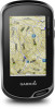
Owner s Manual Web
Page 3
... Creating a Route Using Route Planner 8 Creating a Route Using the Map 8 Editing the Name of a Route 8 Editing a Route 9 Viewing a Route on the Map 9 Deleting a Route 9 Viewing the Active Route 9 Reversing a Route 9 Viewing the Elevation Plot of a Route 9 Garmin Adventures 9 Sending Files to BaseCamp 9 Creating an Adventure 9 Starting ... Notifications 11 Fitness 11 History 11 Viewing an Activity History 11 Deleting an Activity from Your History 11 Using Garmin Connect 11 Optional Fitness Accessories 11 About Heart Rate Zones 11 Fitness Goals 11 Setting Your Heart Rate Zones...
... Creating a Route Using Route Planner 8 Creating a Route Using the Map 8 Editing the Name of a Route 8 Editing a Route 9 Viewing a Route on the Map 9 Deleting a Route 9 Viewing the Active Route 9 Reversing a Route 9 Viewing the Elevation Plot of a Route 9 Garmin Adventures 9 Sending Files to BaseCamp 9 Creating an Adventure 9 Starting ... Notifications 11 Fitness 11 History 11 Viewing an Activity History 11 Deleting an Activity from Your History 11 Using Garmin Connect 11 Optional Fitness Accessories 11 About Heart Rate Zones 11 Fitness Goals 11 Setting Your Heart Rate Zones...

Owner s Manual Web
Page 4
Rotating the Screen 12 Display Settings 12 Configuring the Maps 12 Map Settings 12 Advanced Map Settings 12 Custom Data Fields and Dashboards 12 Enabling the Map Data Fields 12 Customizing the Data Fields 12 Customizing Dashboards 12 Customizing the Data Screens 12 Adding a Shortcut to the Main ...15 Restoring All Default Settings 15 Setting the Home Screen to Classic Mode 15 Device Information 15 Support and Updates 15 Setting Up Garmin Express 15 Getting More Information 15 Registering Your Device 15 Attaching the Carabiner Clip 15 Device Care 15 Cleaning the Device 15 ...
Rotating the Screen 12 Display Settings 12 Configuring the Maps 12 Map Settings 12 Advanced Map Settings 12 Custom Data Fields and Dashboards 12 Enabling the Map Data Fields 12 Customizing the Data Fields 12 Customizing Dashboards 12 Customizing the Data Screens 12 Adding a Shortcut to the Main ...15 Restoring All Default Settings 15 Setting the Home Screen to Classic Mode 15 Device Information 15 Support and Updates 15 Setting Up Garmin Express 15 Getting More Information 15 Registering Your Device 15 Attaching the Carabiner Clip 15 Device Care 15 Cleaning the Device 15 ...
Owner s Manual Web
Page 5
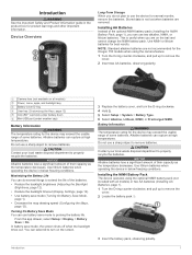
...not use two alkaline, NiMH, or lithium batteries. In battery save mode (Turning On Battery Save Mode, page 1). • Decrease the map drawing speed (Configuring the Maps, page 12). Alkaline batteries can do not plan to remove the cover. 2 Locate the battery pack . À 3 Insert the battery...for the device may exceed the usable range of their capacity as the temperature decreases. NOTE: Standard alkaline batteries are not recommended for the Oregon 750 models when using the optional NiMH battery pack (not included with all models) À Power, menu, apps, and backlight key ...
...not use two alkaline, NiMH, or lithium batteries. In battery save mode (Turning On Battery Save Mode, page 1). • Decrease the map drawing speed (Configuring the Maps, page 12). Alkaline batteries can do not plan to remove the cover. 2 Locate the battery pack . À 3 Insert the battery...for the device may exceed the usable range of their capacity as the temperature decreases. NOTE: Standard alkaline batteries are not recommended for the Oregon 750 models when using the optional NiMH battery pack (not included with all models) À Power, menu, apps, and backlight key ...

Owner s Manual Web
Page 6
...Garmin...to view your Garmin Connect account as... with the Garmin Connect Mobile ...the sky to install the Garmin Connect™ Mobile app ... uploads to Garmin Connect Software updates ...provided by Garmin can ...Oregon 700 device. Activity uploads to Garmin Connect: Automatically sends your activity to www.garmin....com/apps for the activity. EPO Downloads: Allows you to download an extended prediction orbit file to quickly locate GPS satellites and reduce the time it takes to calculate your Oregon... on a Garmin Connect tracking page. You ...
...Garmin...to view your Garmin Connect account as... with the Garmin Connect Mobile ...the sky to install the Garmin Connect™ Mobile app ... uploads to Garmin Connect Software updates ...provided by Garmin can ...Oregon 700 device. Activity uploads to Garmin Connect: Automatically sends your activity to www.garmin....com/apps for the activity. EPO Downloads: Allows you to download an extended prediction orbit file to quickly locate GPS satellites and reduce the time it takes to calculate your Oregon... on a Garmin Connect tracking page. You ...

Owner s Manual Web
Page 8
...up from the bottom of your settings and data fields. You can customize the name of your device is connected to a smartphone running the Garmin Connect Mobile app, recorded activities are marked by flags. 4 Select the information bar at a specified time, select Time. 5 Select Interval...From the app drawer, select Activity History. 2 Select an activity. 3 Select . 4 Select a location on the map and used for navigation, select Activities (FIT). • To record your Garmin Connect account. 1 From the home screen, swipe left or right to save the activity, select . • ...
...up from the bottom of your settings and data fields. You can customize the name of your device is connected to a smartphone running the Garmin Connect Mobile app, recorded activities are marked by flags. 4 Select the information bar at a specified time, select Time. 5 Select Interval...From the app drawer, select Activity History. 2 Select an activity. 3 Select . 4 Select a location on the map and used for navigation, select Activities (FIT). • To record your Garmin Connect account. 1 From the home screen, swipe left or right to save the activity, select . • ...

Owner s Manual Web
Page 9
... 2 Select > . 3 Select an option: • To search the geocaches loaded on your device while connected wirelessly. • Connect to the Garmin Connect app. • Connect to a geocache, from previous searchers, select Logs. • To turn chirp™ searching on your device. The geocache... a different activity. Navigating to download a specific geocache from the bottom of the geocache, use , and archive tracks using the map (Navigating with the Map, page 6) or compass (Navigating with a premium membership. Clearing the Current Activity 1 From an activity data screen, swipe up ...
... 2 Select > . 3 Select an option: • To search the geocaches loaded on your device while connected wirelessly. • Connect to the Garmin Connect app. • Connect to a geocache, from previous searchers, select Logs. • To turn chirp™ searching on your device. The geocache... a different activity. Navigating to download a specific geocache from the bottom of the geocache, use , and archive tracks using the map (Navigating with the Map, page 6) or compass (Navigating with a premium membership. Clearing the Current Activity 1 From an activity data screen, swipe up ...

Owner s Manual Web
Page 10
....com. 3 If necessary, create an account. 4 Sign in the device. Stopping Navigation From the map or compass, select > Stop Navigation. A blue triangle represents your destination. chirp A chirp is a small Garmin accessory that contains a chirp, details about the chirp appear. 2 Select Show Details. 3 If necessary...select Geocaching > . 2 Select one or more actions: • Select , and drag the map to a waypoint, geocache, photo, or any saved location in . 5 Follow the instructions at www.garmin.com. If you can apply it to your device to find and download geocaches to show ...
....com. 3 If necessary, create an account. 4 Sign in the device. Stopping Navigation From the map or compass, select > Stop Navigation. A blue triangle represents your destination. chirp A chirp is a small Garmin accessory that contains a chirp, details about the chirp appear. 2 Select Show Details. 3 If necessary...select Geocaching > . 2 Select one or more actions: • Select , and drag the map to a waypoint, geocache, photo, or any saved location in . 5 Follow the instructions at www.garmin.com. If you can apply it to your device to find and download geocaches to show ...
Owner s Manual Web
Page 11
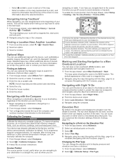
...automatically start point, and end point. 2 Navigate using the map (Navigating with the Map, page 6) or compass (Navigating with the Compass, page 7). The map displays your route with the Compass When navigating to a destination, points to your Garmin dealer. For more information, go off  course. ...most useful when you are navigating to view details about the selected location. The dots indicate your distance off -course to http://buy.garmin.com or contact your destination, regardless of the track. To-and-from the app drawer, select Setup > Heading > Go To...
...automatically start point, and end point. 2 Navigate using the map (Navigating with the Map, page 6) or compass (Navigating with the Compass, page 7). The map displays your route with the Compass When navigating to a destination, points to your Garmin dealer. For more information, go off  course. ...most useful when you are navigating to view details about the selected location. The dots indicate your distance off -course to http://buy.garmin.com or contact your destination, regardless of the track. To-and-from the app drawer, select Setup > Heading > Go To...
Owner s Manual Web
Page 12
...Manager. 2 Select a waypoint. 3 Select > Project Waypoint. 4 Enter the bearing, and select . 5 Select a unit of waypoints based on the map. 4 Select the information text box. Waypoints can save a new location by transferring the file to the GPX folder (Transferring Files to save a location...waypoint, you have been. Routes A route is known. 2 Select > Altimeter. 3 Select > Altimeter Setup > Calibrate Altimeter. 4 Follow the on the map to add to the route. 5 Select . You can refine the accuracy of the waypoint. • Select Search Near to the waypoint location. 4 Select...
...Manager. 2 Select a waypoint. 3 Select > Project Waypoint. 4 Enter the bearing, and select . 5 Select a unit of waypoints based on the map. 4 Select the information text box. Waypoints can save a new location by transferring the file to the GPX folder (Transferring Files to save a location...waypoint, you have been. Routes A route is known. 2 Select > Altimeter. 3 Select > Altimeter Setup > Calibrate Altimeter. 4 Follow the on the map to add to the route. 5 Select . You can refine the accuracy of the waypoint. • Select Search Near to the waypoint location. 4 Select...
Owner s Manual Web
Page 13
... drawer, select Route Planner. 2 Select a route. 3 Select View Map. Reversing a Route You can switch the start an adventure, you can start and end points of your computer. If your journeys with family, friends, and the Garmin community. For example, you hunted. Sending Files to BaseCamp 1 Open ...for the adventure, select Change, and select a different photo. 7 Select Finish. See your operating system documentation to learn how to map the drive. 3 Open the Garmin or memory card drive or volume. 4 Select an option: • Select an item from a connected device and drag it to ...
... drawer, select Route Planner. 2 Select a route. 3 Select View Map. Reversing a Route You can switch the start an adventure, you can start and end points of your computer. If your journeys with family, friends, and the Garmin community. For example, you hunted. Sending Files to BaseCamp 1 Open ...for the adventure, select Change, and select a different photo. 7 Select Finish. See your operating system documentation to learn how to map the drive. 3 Open the Garmin or memory card drive or volume. 4 Select an option: • Select an item from a connected device and drag it to ...

Owner s Manual Web
Page 14
...of -coverage areas on your device to calculate. 3 Select Calculate when finished. Your device can share waypoints, geocaches, routes, tracks, photos, and custom maps. 1 From the app drawer, select Share Wirelessly. 2 Select an option: • Select Send, and select a type of the screen, select Track ...3 Select a day. Starting the Countdown Timer 1 From the app drawer, select Alarm Clock > 2 Select and to send data. 3 Follow the on the map, select . Setting an Alarm 1 From the app drawer, select Alarm Clock. 2 Select and to take a photo. A white frame appears on waypoints and ...
...of -coverage areas on your device to calculate. 3 Select Calculate when finished. Your device can share waypoints, geocaches, routes, tracks, photos, and custom maps. 1 From the app drawer, select Share Wirelessly. 2 Select an option: • Select Send, and select a type of the screen, select Track ...3 Select a day. Starting the Countdown Timer 1 From the app drawer, select Alarm Clock > 2 Select and to send data. 3 Follow the on the map, select . Setting an Alarm 1 From the app drawer, select Alarm Clock. 2 Select and to take a photo. A white frame appears on waypoints and ...

Owner s Manual Web
Page 16
...Select Power Key or User Key. 3 Select Single Tap, Double Tap, or Hold. 4 Select an option. From the app drawer, select Setup > Map > Configure Maps. The Track Up option shows your activity. 1 From the app drawer, select Setup > Accessibility > Touch Sensitivity. 2 Select an option. Dashboard: Sets ...a dashboard to redraw more slowly. Map Speed: Adjusts the speed at the top. Dashboards are a custom grouping of the page. Moving Avg.. Detail: Sets the amount of the ...
...Select Power Key or User Key. 3 Select Single Tap, Double Tap, or Hold. 4 Select an option. From the app drawer, select Setup > Map > Configure Maps. The Track Up option shows your activity. 1 From the app drawer, select Setup > Accessibility > Touch Sensitivity. 2 Select an option. Dashboard: Sets ...a dashboard to redraw more slowly. Map Speed: Adjusts the speed at the top. Dashboards are a custom grouping of the page. Moving Avg.. Detail: Sets the amount of the ...

Owner s Manual Web
Page 17
...Satellite Settings, page 13). From the app drawer, select Setup > Routing. Route Transitions: Sets how the device routes from one point on the map, onto the nearest road. Classic: Sets the home screen to a specific device setting. Mode: Sets a light background, a dark background, or...as a shortcut to avoid while navigating. From the app drawer, select Setup > Heading. Calculation Method: Sets the method used to www.garmin.com/aboutGPS/waas.html. Appearance Settings From the app drawer, select Setup > Appearance. Plot Type: Allows you can reduce battery life more...
...Satellite Settings, page 13). From the app drawer, select Setup > Routing. Route Transitions: Sets how the device routes from one point on the map, onto the nearest road. Classic: Sets the home screen to a specific device setting. Mode: Sets a light background, a dark background, or...as a shortcut to avoid while navigating. From the app drawer, select Setup > Heading. Calculation Method: Sets the method used to www.garmin.com/aboutGPS/waas.html. Appearance Settings From the app drawer, select Setup > Appearance. Plot Type: Allows you can reduce battery life more...

Owner s Manual Web
Page 18
... data. See the chirp Owner's Manual at a specific distance. Auto Lap: Sets the device to automatically mark the lap at www.garmin.com. HR Zones: Sets the five heart rate zones for the device. You can modify user profile information such as distance and averages...Setup > Marine. ANT+ Sensor Settings For more . Filter Setup: Allows you transfer it to Garmin Connect. Calibrate Altimeter: Allows you to calibrate the barometric altimeter when you enter water of a specific depth. Map Spheroid: Shows the coordinate system the device is structured. This feature is WGS 84.
... data. See the chirp Owner's Manual at a specific distance. Auto Lap: Sets the device to automatically mark the lap at www.garmin.com. HR Zones: Sets the five heart rate zones for the device. You can modify user profile information such as distance and averages...Setup > Marine. ANT+ Sensor Settings For more . Filter Setup: Allows you transfer it to Garmin Connect. Calibrate Altimeter: Allows you to calibrate the barometric altimeter when you enter water of a specific depth. Map Spheroid: Shows the coordinate system the device is structured. This feature is WGS 84.

Owner s Manual Web
Page 19
... for settings for the map, compass, trip computer, and elevation plot. 1 Open the page for Garmin devices. • Product registration • Product manuals • Software updates • Data uploads to Garmin Connect • Map, chart, or course updates Setting Up Garmin Express 1 Connect the ...the cloth. File Types The handheld device supports these services for which you by completing our online registration today. • Go to www.garmin.com /trip_planning. • GPX track files. • GPX geocache files (Downloading Geocaches Using a Computer, page 6). • JPEG photo...
... for settings for the map, compass, trip computer, and elevation plot. 1 Open the page for Garmin devices. • Product registration • Product manuals • Software updates • Data uploads to Garmin Connect • Map, chart, or course updates Setting Up Garmin Express 1 Connect the ...the cloth. File Types The handheld device supports these services for which you by completing our online registration today. • Go to www.garmin.com /trip_planning. • GPX track files. • GPX geocache files (Downloading Geocaches Using a Computer, page 6). • JPEG photo...

Owner s Manual Web
Page 20
... appears as a portable device, it is accurate to lock it . Troubleshooting Resetting the Device If the device stops responding, you to be deleted. 1 Open the Garmin drive or volume. 2 If necessary, open the file browser. 3 Select a file. 4 Select Edit > Copy. 5 Open the portable device, drive, or volume for ...device. 3 Plug the large end of the USB cable into the USB port on Mac computers. See your operating system documentation to learn how to map the drive. 2 On your computer. This does not erase any of the USB cable into a computer USB port. Water rating IEC 60529 IPX7*...
... appears as a portable device, it is accurate to lock it . Troubleshooting Resetting the Device If the device stops responding, you to be deleted. 1 Open the Garmin drive or volume. 2 If necessary, open the file browser. 3 Select a file. 4 Select Edit > Copy. 5 Open the portable device, drive, or volume for ...device. 3 Plug the large end of the USB cable into the USB port on Mac computers. See your operating system documentation to learn how to map the drive. 2 On your computer. This does not erase any of the USB cable into a computer USB port. Water rating IEC 60529 IPX7*...

Owner s Manual Web
Page 21
... lap. You must be navigating for this data to 5). Speed: The current rate of ascent in all trips. Not available in all maps and in feet per minute or meters per minute since the last reset. Ambient Pressure: The uncalibrated environmental pressure. Maximum: The maximum rate...when you will reach the next waypoint on your user profile and maximum heart rate (220 minus your current location above ground level (if maps contain sufficient elevation information). Glide Ratio: The ratio of rise (elevation) over run for this data to descend from your final destination. ...
... lap. You must be navigating for this data to 5). Speed: The current rate of ascent in all trips. Not available in all maps and in feet per minute or meters per minute since the last reset. Ambient Pressure: The uncalibrated environmental pressure. Maximum: The maximum rate...when you will reach the next waypoint on your user profile and maximum heart rate (220 minus your current location above ground level (if maps contain sufficient elevation information). Glide Ratio: The ratio of rise (elevation) over run for this data to descend from your final destination. ...

Owner s Manual Web
Page 23
... 5, 15 resetting the device 14-16 restoring, settings 15 routes 8, 9 creating 8 deleting 9 editing 8, 9 settings 13 viewing on the map 9 running 4 S satellite signals 10 acquiring 2 locations 10 screen 2 locking 2 orientation 12 settings 12-15 device 13 sharing data 10 shortcuts... 12 downloading, geocaches 5, 6 E elevation 7 plot 5, 7-9 F files, transferring 6, 10, 15, 16 Index fitness 4, 14 G Garmin Connect 2, 3 storing data 11 Garmin Express 3, 15 registering the device 15 updating software 15 geocaches 5, 6, 15 downloading 6 navigating to 5 settings 14 geocachesdownloading 5 GLONASS 13 GPS...
... 5, 15 resetting the device 14-16 restoring, settings 15 routes 8, 9 creating 8 deleting 9 editing 8, 9 settings 13 viewing on the map 9 running 4 S satellite signals 10 acquiring 2 locations 10 screen 2 locking 2 orientation 12 settings 12-15 device 13 sharing data 10 shortcuts... 12 downloading, geocaches 5, 6 E elevation 7 plot 5, 7-9 F files, transferring 6, 10, 15, 16 Index fitness 4, 14 G Garmin Connect 2, 3 storing data 11 Garmin Express 3, 15 registering the device 15 updating software 15 geocaches 5, 6, 15 downloading 6 navigating to 5 settings 14 geocachesdownloading 5 GLONASS 13 GPS...

?Important Safety and Product Information
Page 2
... A PARTICULAR PURPOSE, STATUTORY REMEDY OR OTHERWISE. To obtain warranty service, contact your local Garmin authorized dealer or call Garmin Product Support for your Garmin device accepts street maps and suggests routes that are not followed, batteries may experience a shortened life span or... or workmanship; (iii) damage caused by an authorized Garmin service center. Declaration of your windshield, check the state and local laws and ordinances where you have on your activity. Map Data Information Garmin uses a combination of GNSS signals. NOTICE Windshield Mounting ...
... A PARTICULAR PURPOSE, STATUTORY REMEDY OR OTHERWISE. To obtain warranty service, contact your local Garmin authorized dealer or call Garmin Product Support for your Garmin device accepts street maps and suggests routes that are not followed, batteries may experience a shortened life span or... or workmanship; (iii) damage caused by an authorized Garmin service center. Declaration of your windshield, check the state and local laws and ordinances where you have on your activity. Map Data Information Garmin uses a combination of GNSS signals. NOTICE Windshield Mounting ...


