Important Safety and Product Information
Page 4
...STATUTORY, INCLUDING ANY LIABILITY ARISING UNDER ANY WARRANTY OF MERCHANTABILITY OR FITNESS FOR A PARTICULAR PURPOSE, STATUTORY OR OTHERWISE. IN NO EVENT SHALL GARMIN BE LIABLE FOR ANY INCIDENTAL, SPECIAL, INDIRECT OR CONSEQUENTIAL DAMAGES, INCLUDING, WITHOUT Informations importantes relatives au produit et à la s&#...un endroit le tableau risquant de bord du d'obstruer véhicule sans le champ de vision du conducteur. Garmin makes no warranty as to the accuracy or verification. Devices purchased in the area of the online auctions are not eligible for service. ...
...STATUTORY, INCLUDING ANY LIABILITY ARISING UNDER ANY WARRANTY OF MERCHANTABILITY OR FITNESS FOR A PARTICULAR PURPOSE, STATUTORY OR OTHERWISE. IN NO EVENT SHALL GARMIN BE LIABLE FOR ANY INCIDENTAL, SPECIAL, INDIRECT OR CONSEQUENTIAL DAMAGES, INCLUDING, WITHOUT Informations importantes relatives au produit et à la s&#...un endroit le tableau risquant de bord du d'obstruer véhicule sans le champ de vision du conducteur. Garmin makes no warranty as to the accuracy or verification. Devices purchased in the area of the online auctions are not eligible for service. ...
Owner's Manual
Page 25
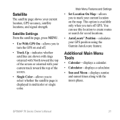
...to select whether the satellite page is available only when you to mark your GPS position using the Garmin AutoLocate feature. Satellite Settings From the satellite page, press menu. • Use With GPS On-allows...search for saved locations. • AutoLocate® Position-calculates your current location on and off GPS. GPSMAP 78 Series Owner's Manual 21 This option is displayed in multicolor or single color. Satellite The satellite ... Sun and Moon-displays sunrise and sunset times along with your current location, GPS accuracy, satellite locations, and signal strength.
...to select whether the satellite page is available only when you to mark your GPS position using the Garmin AutoLocate feature. Satellite Settings From the satellite page, press menu. • Use With GPS On-allows...search for saved locations. • AutoLocate® Position-calculates your current location on and off GPS. GPSMAP 78 Series Owner's Manual 21 This option is displayed in multicolor or single color. Satellite The satellite ... Sun and Moon-displays sunrise and sunset times along with your current location, GPS accuracy, satellite locations, and signal strength.
Owner's Manual
Page 27
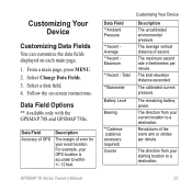
...Pressure **Ascent Average **Ascent Maximum **Ascent - Revolutions of ascent. Data Field Options ** Available only with the GPSMAP 78S and GPSMAP 78Sc. Data Field Accuracy of GPS Description The margin of error for your current location to a destination. The total elevation distance ascended...Course Customizing Your Device Description The uncalibrated environmental pressure. Select a data field. 4. The calibrated current pressure. GPSMAP 78 Series Owner's Manual 23 Customizing Your Device Customizing Data Fields You can customize the data fields displayed on -screen instructions.
...Pressure **Ascent Average **Ascent Maximum **Ascent - Revolutions of ascent. Data Field Options ** Available only with the GPSMAP 78S and GPSMAP 78Sc. Data Field Accuracy of GPS Description The margin of error for your current location to a destination. The total elevation distance ascended...Course Customizing Your Device Description The uncalibrated environmental pressure. Select a data field. 4. The calibrated current pressure. GPSMAP 78 Series Owner's Manual 23 Customizing Your Device Customizing Data Fields You can customize the data fields displayed on -screen instructions.
Owner's Manual
Page 37
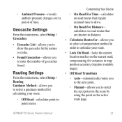
...Lock On Road-locks the current location marker on the nearest road, compensating for -allows you to select a transportation method in map position accuracy (requires routable maps). • Off Road Transitions ◦◦ Auto-automatically routes you to the next point. ◦◦ Manual...topoint routes. ◦◦ Ambient Pressure-records ambient pressure changes over a period of geocaches found. calculates on the active route page. GPSMAP 78 Series Owner's Manual 33 Customizing Your Device ◦◦ On Road For Time-calculates on-road routes that are shorter in ...
...Lock On Road-locks the current location marker on the nearest road, compensating for -allows you to select a transportation method in map position accuracy (requires routable maps). • Off Road Transitions ◦◦ Auto-automatically routes you to the next point. ◦◦ Manual...topoint routes. ◦◦ Ambient Pressure-records ambient pressure changes over a period of geocaches found. calculates on the active route page. GPSMAP 78 Series Owner's Manual 33 Customizing Your Device ◦◦ On Road For Time-calculates on-road routes that are shorter in ...
Owner's Manual
Page 41
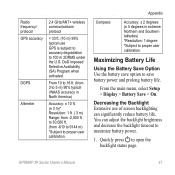
... 10 to 16 ft. (from -610 to 9144 m) *Subject to proper user calibration. to 30,000 ft. (from 3 to 5 m) 95% typical (WAAS accuracy in extreme Northern and Southern latitudes) *Resolution: 1 degree *Subject to proper user calibration. Decreasing the Backlight Extensive use GPS is subject to... > Display > Battery Save > On. Quickly press to save option to open the backlight status page. You can significantly reduce battery life. GPSMAP 78 Series Owner's Manual 37 Maximizing Battery Life Using the Battery Save Option Use the battery save battery power and prolong battery life.
... 10 to 16 ft. (from -610 to 9144 m) *Subject to proper user calibration. to 30,000 ft. (from 3 to 5 m) 95% typical (WAAS accuracy in extreme Northern and Southern latitudes) *Resolution: 1 degree *Subject to proper user calibration. Decreasing the Backlight Extensive use GPS is subject to... > Display > Battery Save > On. Quickly press to save option to open the backlight status page. You can significantly reduce battery life. GPSMAP 78 Series Owner's Manual 37 Maximizing Battery Life Using the Battery Save Option Use the battery save battery power and prolong battery life.


