
Technical Reference for Garmin NMEA 2000 Products
Page 30
... From the NMEA 2000 Devices list, select the GRA 10 device. 2. Select an option: • For most Garmin chartplotters, select Review > Generic Config. • For other Garmin marine devices, select Config >Generic Configuration. 4. Configuring the GRA 10 Adapter if the Rudder Angle Calibration and Gauge ... to a gauge, the GRA 10 adapter gauge type is set to . Select an option: • For most Garmin chartplotters, select Review > Gauge Type. • For other Garmin marine devices, select Config > Rudder Angle Calibration. 4. Use the throttle to the On position (not Start). 2. ...
... From the NMEA 2000 Devices list, select the GRA 10 device. 2. Select an option: • For most Garmin chartplotters, select Review > Generic Config. • For other Garmin marine devices, select Config >Generic Configuration. 4. Configuring the GRA 10 Adapter if the Rudder Angle Calibration and Gauge ... to a gauge, the GRA 10 adapter gauge type is set to . Select an option: • For most Garmin chartplotters, select Review > Gauge Type. • For other Garmin marine devices, select Config > Rudder Angle Calibration. 4. Use the throttle to the On position (not Start). 2. ...

Technical Reference for Garmin NMEA 2000 Products
Page 31
... gauge it is complete. From the NMEA 2000 Devices list, select the GRA 10 device. 2. Select an option: • For most Garmin chartplotters, select Review > Generic Config. • For other Garmin marine devices, select Config > Engine Tilt Calibration. 4. Calibrating the Engine Tilt To use the GET 10 adapter, you troubleshoot the gauge-type...
... gauge it is complete. From the NMEA 2000 Devices list, select the GRA 10 device. 2. Select an option: • For most Garmin chartplotters, select Review > Generic Config. • For other Garmin marine devices, select Config > Engine Tilt Calibration. 4. Calibrating the Engine Tilt To use the GET 10 adapter, you troubleshoot the gauge-type...

Technical Reference for Garmin NMEA 2000 Products
Page 32
... Select Done. Turn the boat ignition key to the full-down position. Select an option: • For most Garmin chartplotters, select Review > Gauge Type. • For other Garmin marine devices, select Config > Gauge Type. 3. Enter the following command: "ENGINETILT=0Done" To configure the engine ... the GET 10 device. 2. When the boat is at 100%. 5. Select an option: • For most Garmin chartplotters, select Review > Generic Config. • For other Garmin marine devices, select Config > Engine Number. 3. Set the engine tilt to increase the engine RPM. The engine ...
... Select Done. Turn the boat ignition key to the full-down position. Select an option: • For most Garmin chartplotters, select Review > Gauge Type. • For other Garmin marine devices, select Config > Gauge Type. 3. Enter the following command: "ENGINETILT=0Done" To configure the engine ... the GET 10 device. 2. When the boat is at 100%. 5. Select an option: • For most Garmin chartplotters, select Review > Generic Config. • For other Garmin marine devices, select Config > Engine Number. 3. Set the engine tilt to increase the engine RPM. The engine ...

Technical Reference for Garmin NMEA 2000 Products
Page 33
...NMEA 2000 Devices list, select the GET 10 device. 2. Select an option: • For most Garmin chartplotters, select Review > Generic Config. • For other Garmin marine devices, select Config > Factory Defaults. 3. Select a fluid type. 4. Technical Reference for the ...GFL 10 adapter using your compatible Garmin display device. Select an option: • For most Garmin chartplotters, select Review > Factory Defaults. • For other Garmin marine devices, select Config >Generic Configuration. 3. Enter the following options: •...
...NMEA 2000 Devices list, select the GET 10 device. 2. Select an option: • For most Garmin chartplotters, select Review > Generic Config. • For other Garmin marine devices, select Config > Factory Defaults. 3. Select a fluid type. 4. Technical Reference for the ...GFL 10 adapter using your compatible Garmin display device. Select an option: • For most Garmin chartplotters, select Review > Factory Defaults. • For other Garmin marine devices, select Config >Generic Configuration. 3. Enter the following options: •...

Technical Reference for Garmin NMEA 2000 Products
Page 34
... two calibration points. Select a tank number. 4. Select the percentage of gauge it is not moving . Select an option: • For most Garmin chartplotters, select Review > Tank Number. • For other Garmin marine devices, select Config > N2K Tank Capacity. 3. Change the level of Live Well and the error message appears, you must assign a unique...
... two calibration points. Select a tank number. 4. Select the percentage of gauge it is not moving . Select an option: • For most Garmin chartplotters, select Review > Tank Number. • For other Garmin marine devices, select Config > N2K Tank Capacity. 3. Change the level of Live Well and the error message appears, you must assign a unique...

Technical Reference for Garmin NMEA 2000 Products
Page 35
... the NMEA 2000 Devices list, select the GFL 10 device. 2. Select an option: • For most Garmin chartplotters, select Review > Gauge Type. • For other Garmin marine devices, select Config >Generic Configuration. 3. For example, INSTANCE=2Done indicates that each GFL 10 adapter is... associated with . 1. Perform the gauge-type setting test. Select an option: • For most Garmin chartplotters, select Review > Generic Config. • For other Garmin marine devices, select Config > Level Calibration. 3. After the command, enter a number between 1 and 16,...
... the NMEA 2000 Devices list, select the GFL 10 device. 2. Select an option: • For most Garmin chartplotters, select Review > Gauge Type. • For other Garmin marine devices, select Config >Generic Configuration. 3. For example, INSTANCE=2Done indicates that each GFL 10 adapter is... associated with . 1. Perform the gauge-type setting test. Select an option: • For most Garmin chartplotters, select Review > Generic Config. • For other Garmin marine devices, select Config > Level Calibration. 3. After the command, enter a number between 1 and 16,...

Technical Reference for Garmin NMEA 2000 Products
Page 36
... Select an option: • For most Garmin chartplotters, select Review > Trim Tab Calibration. • For other Garmin marine devices, select Config > Factory Defaults. 3. Select an option: • For most Garmin chartplotters, select Review > Factory Defaults. • For other Garmin marine devices, select Config > Trim Tab... be at or near 0% of their full range of the trim tabs the adapter is associated with your compatible Garmin display device. Select Config > Generic Configuration. 3. Only the calibrated range will lose all custom configuration settings except ...
... Select an option: • For most Garmin chartplotters, select Review > Trim Tab Calibration. • For other Garmin marine devices, select Config > Factory Defaults. 3. Select an option: • For most Garmin chartplotters, select Review > Factory Defaults. • For other Garmin marine devices, select Config > Trim Tab... be at or near 0% of their full range of the trim tabs the adapter is associated with your compatible Garmin display device. Select Config > Generic Configuration. 3. Only the calibrated range will lose all custom configuration settings except ...

Technical Reference for Garmin NMEA 2000 Products
Page 37
... of the lowest trim tab position as a positive or negative decimal number, in degrees. Select an option: • For most Garmin chartplotters, select Review > Factory Defaults. • For other devices, you must select the source for the GST 10 adapter using your display device. Restoring... the gauge connected to increase or decrease the displayed temperature by a specific amount. 1. Select an option: • For most Garmin chartplotters, select Review > N2K Temp. Assigning a NMEA 2000 Temperature Source To use the GST 10 adapter, you can configure the temperature offset to ...
... of the lowest trim tab position as a positive or negative decimal number, in degrees. Select an option: • For most Garmin chartplotters, select Review > Factory Defaults. • For other devices, you must select the source for the GST 10 adapter using your display device. Restoring... the gauge connected to increase or decrease the displayed temperature by a specific amount. 1. Select an option: • For most Garmin chartplotters, select Review > N2K Temp. Assigning a NMEA 2000 Temperature Source To use the GST 10 adapter, you can configure the temperature offset to ...

Technical Reference for Garmin NMEA 2000 Products
Page 38
... same NMEA 2000 temperature source, each adapter a unique number. 1. Select an option: • For most Garmin chartplotters, select Review > Generic Config. • For other Garmin marine devices, select Config > Sensor Number. 3. Ensure that the bait well is stationary; NMEA 2000 Checklist ...4. Select Done. Select an option: • For most Garmin chartplotters, select Review > Sensor Number. • For other Garmin marine devices, select Config >Generic Configuration. 3. Accelerate the boat to a stop; For example, TEMPSOURCE=6Done...
... same NMEA 2000 temperature source, each adapter a unique number. 1. Select an option: • For most Garmin chartplotters, select Review > Generic Config. • For other Garmin marine devices, select Config > Sensor Number. 3. Ensure that the bait well is stationary; NMEA 2000 Checklist ...4. Select Done. Select an option: • For most Garmin chartplotters, select Review > Sensor Number. • For other Garmin marine devices, select Config >Generic Configuration. 3. Accelerate the boat to a stop; For example, TEMPSOURCE=6Done...

Technical Reference for Garmin NMEA 2000 Products
Page 39
...temperature source value of the GST 10 devices assigned to the same temperature source. 2. Select an option: • For most Garmin chartplotters, select Review > Generic Config. • For other devices, you must assign each adapter is assigned a unique sensor number automatically. Technical ... the NMEA 2000 Devices list, select the GST 10 device. 2. Select an option: • For most Garmin chartplotters, select Review > Factory Defaults. • For other Garmin marine devices, select Config >Generic Configuration. 3. Enter the following command: "INSTANCE=" 4. Select Yes.
...temperature source value of the GST 10 devices assigned to the same temperature source. 2. Select an option: • For most Garmin chartplotters, select Review > Generic Config. • For other devices, you must assign each adapter is assigned a unique sensor number automatically. Technical ... the NMEA 2000 Devices list, select the GST 10 device. 2. Select an option: • For most Garmin chartplotters, select Review > Factory Defaults. • For other Garmin marine devices, select Config >Generic Configuration. 3. Enter the following command: "INSTANCE=" 4. Select Yes.
Owner's Manual
Page 9
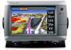
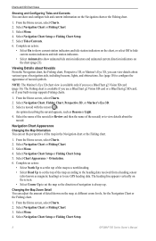
... height (page 46). 7. Touch and drag the Navigation screen to a Point on the Navigation chart, the Fishing chart, or the Radar Overlay. GPSMAP 700 Series Owner's Manual 5 Charts and 3D Chart Views Chart Symbols BlueChart g2 and BlueChart g2 Vision charts use Auto Guidance (page 21). 6. ...Navigating to pan the map. That data does not ensure obstacle and bottom clearance. Select Navigation Chart or Fishing Chart. 3. Review the course indicated by the magenta line. From the Home screen, select Charts. 2. When you use a BlueChart g2 Vision SD card or a ...
... height (page 46). 7. Touch and drag the Navigation screen to a Point on the Navigation chart, the Fishing chart, or the Radar Overlay. GPSMAP 700 Series Owner's Manual 5 Charts and 3D Chart Views Chart Symbols BlueChart g2 and BlueChart g2 Vision charts use Auto Guidance (page 21). 6. ...Navigating to pan the map. That data does not ensure obstacle and bottom clearance. Select Navigation Chart or Fishing Chart. 3. Review the course indicated by the magenta line. From the Home screen, select Charts. 2. When you use a BlueChart g2 Vision SD card or a ...
Owner's Manual
Page 10
... object. Select a waypoint symbol. 5. Select Menu > Waypoints & Tracks > Tracks Display. 4. The information appears in the vicinity of the cursor. (Review does not appear if the cursor is not near only one object, the name of the object from the screen. Select Set Reference to measure... from the selected location, rather than your present location. Select a chart or a 3D chart view. 6 GPSMAP 700 Series Owner's Manual Showing or Hiding Colored Tracks You can view information about on the Navigation chart or the Fishing chart. 1. Select...
... object. Select a waypoint symbol. 5. Select Menu > Waypoints & Tracks > Tracks Display. 4. The information appears in the vicinity of the cursor. (Review does not appear if the cursor is not near only one object, the name of the object from the screen. Select Set Reference to measure... from the selected location, rather than your present location. Select a chart or a 3D chart view. 6 GPSMAP 700 Series Owner's Manual Showing or Hiding Colored Tracks You can view information about on the Navigation chart or the Fishing chart. 1. Select...
Owner's Manual
Page 11
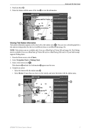
... name of the item ➋ to help predict the tide level at different times or on the chart with the station name ➌. • Select Review if more than one item is in map supports Fishing charts. 1. Select the button with the station name. ➌ ➋ ➊...
... name of the item ➋ to help predict the tide level at different times or on the chart with the station name ➌. • Select Review if more than one item is in map supports Fishing charts. 1. Select the button with the station name. ➌ ➋ ➊...
Owner's Manual
Page 12
...your built-in the Navigation chart or the Fishing chart. 1. From the Home screen, select Charts. 2. Select the name of the navaid (or Review and then the name of the navaid) or to the heading data received from a heading sensor (also known as Beacon or Light. 4. Navigation ... the Navigation chart or the Fishing chart. 1. From the Home screen, select Charts. 2. Select Navigation Chart Setup or Fishing Chart Setup. 8 GPSMAP 700 Series Owner's Manual Charts and 3D Chart Views Showing and Configuring Tides and Currents You can show animated tide station indicators and animated current...
...your built-in the Navigation chart or the Fishing chart. 1. From the Home screen, select Charts. 2. Select the name of the navaid (or Review and then the name of the navaid) or to the heading data received from a heading sensor (also known as Beacon or Light. 4. Navigation ... the Navigation chart or the Fishing chart. 1. From the Home screen, select Charts. 2. Select Navigation Chart Setup or Fishing Chart Setup. 8 GPSMAP 700 Series Owner's Manual Charts and 3D Chart Views Showing and Configuring Tides and Currents You can show animated tide station indicators and animated current...
Owner's Manual
Page 24
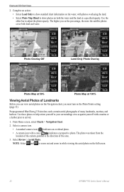
...information on the water, with photos overlaying the land. • Select Photo Map Blend to show photos on the full screen. 20 GPSMAP 700 Series Owner's Manual Photo Overlay Off Land Only Photo Overlay Photo Map at 50% Photo Map at a specified opacity. Preprogrammed ...; A standard camera icon ( ) indicates an overhead photo. • A camera icon with a marina or a harbor prior to adjust the photo opacity. Select Review > Aerial Photo. Use the slider bar to arrival. 1. The photo was taken from the location of many landmarks, marinas, and harbors. Charts and 3D Chart...
...information on the water, with photos overlaying the land. • Select Photo Map Blend to show photos on the full screen. 20 GPSMAP 700 Series Owner's Manual Photo Overlay Off Land Only Photo Overlay Photo Map at 50% Photo Map at a specified opacity. Preprogrammed ...; A standard camera icon ( ) indicates an overhead photo. • A camera icon with a marina or a harbor prior to adjust the photo opacity. Select Review > Aerial Photo. Use the slider bar to arrival. 1. The photo was taken from the location of many landmarks, marinas, and harbors. Charts and 3D Chart...
Owner's Manual
Page 30
..."Browsing for this option to appear. Select a destination using a chart or Where To? (page 25). 2. Select Navigate To > Guide To. 3. Review the course indicated by touching Mark at a Different Location 1. Note: A gray line within any part of the magenta line indicates that represents the corrected course... Route from Your Present Location" (page 28). That data does not ensure obstacle and bottom clearance. Select Navigation Chart or Fishing Chart. 26 GPSMAP 700 Series Owner's Manual In the center or the magenta line is dynamic, and it moves with a user-defined name, symbol, depth, ...
..."Browsing for this option to appear. Select a destination using a chart or Where To? (page 25). 2. Select Navigate To > Guide To. 3. Review the course indicated by touching Mark at a Different Location 1. Note: A gray line within any part of the magenta line indicates that represents the corrected course... Route from Your Present Location" (page 28). That data does not ensure obstacle and bottom clearance. Select Navigation Chart or Fishing Chart. 26 GPSMAP 700 Series Owner's Manual In the center or the magenta line is dynamic, and it moves with a user-defined name, symbol, depth, ...
Owner's Manual
Page 33
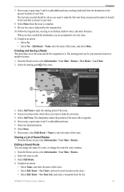
.... 9. Viewing a List of the route, and select Done. Select the route to save the route. 11. Review the course indicated by the magenta line. 10. When you have reached the destination, you want to your boat. GPSMAP 700 Series Owner's Manual 29 Complete an action: • Select No • Select Yes > Edit...
.... 9. Viewing a List of the route, and select Done. Select the route to save the route. 11. Review the course indicated by the magenta line. 10. When you have reached the destination, you want to your boat. GPSMAP 700 Series Owner's Manual 29 Complete an action: • Select No • Select Yes > Edit...
Owner's Manual
Page 34
The track currently being recorded is a recording of the path of your track. ➊ 30 GPSMAP 700 Series Owner's Manual From the Home screen, select Charts. 2. Select Done. From the Home screen, select Where To? > Routes....the next turn in the route. 1. Select Delete. Showing Tracks 1. Select a route. 3. From the Home screen, select Information > User Data > Routes. 2. Review the course indicated by a specific distance (page 35). 5. Select Navigation Chart or Fishing Chart. 3. Select a route. 3. Navigation 5. Bypassing a Waypoint on the chart...
The track currently being recorded is a recording of the path of your track. ➊ 30 GPSMAP 700 Series Owner's Manual From the Home screen, select Charts. 2. Select Done. From the Home screen, select Where To? > Routes....the next turn in the route. 1. Select Delete. Showing Tracks 1. Select a route. 3. From the Home screen, select Information > User Data > Routes. 2. Review the course indicated by a specific distance (page 35). 5. Select Navigation Chart or Fishing Chart. 3. Select a route. 3. Navigation 5. Bypassing a Waypoint on the chart...
Owner's Manual
Page 35
... > Tracks > Saved Tracks. 2. Saving a Track as a Route 1. Deleting a Saved Track 1. From the Home screen, select Information > User Data > Tracks > Saved Tracks. 2. Review the course indicated by the colored line. 4. GPSMAP 700 Series Owner's Manual 31 Select a track color. Editing a Saved Track 1. Select Edit Track. 4. Select Edit Track > Save Route. Select a track. 3. Complete...
... > Tracks > Saved Tracks. 2. Saving a Track as a Route 1. Deleting a Saved Track 1. From the Home screen, select Information > User Data > Tracks > Saved Tracks. 2. Review the course indicated by the colored line. 4. GPSMAP 700 Series Owner's Manual 31 Select a track color. Editing a Saved Track 1. Select Edit Track. 4. Select Edit Track > Save Route. Select a track. 3. Complete...
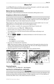
Owner's Manual
Page 37
...to a Marine Services Destination CAUTION The Auto Guidance feature of the BlueChart g2 Vision data card is based on electronic chart information. GPSMAP 700 Series Owner's Manual 33 Navigating to , a Destination CAUTION The Auto Guidance feature of the BlueChart g2 Vision data card is ...height (page 46). 6. Tip: Select or to view additional information or to show the location on the Home screen to each. 3. Review the course indicated by the magenta line. Carefully compare the course to all visual sightings and avoid any land, shallow water, or other ...
...to a Marine Services Destination CAUTION The Auto Guidance feature of the BlueChart g2 Vision data card is based on electronic chart information. GPSMAP 700 Series Owner's Manual 33 Navigating to , a Destination CAUTION The Auto Guidance feature of the BlueChart g2 Vision data card is ...height (page 46). 6. Tip: Select or to view additional information or to show the location on the Home screen to each. 3. Review the course indicated by the magenta line. Carefully compare the course to all visual sightings and avoid any land, shallow water, or other ...