Installation Instructions
Page 1
... 6) • Connecting the chartplotter to a GA 30 remote GPS antenna (page 6). • Connecting the chartplotter to a Garmin marine radar (page 6). • Connecting the chartplotter to other important information. Caution Always wear safety goggles, ear protection, and a dust mask when drilling, cutting, or sanding. February 2010 Part Number 190-01155-02 Rev. GPSMAP® 700 Series...
... 6) • Connecting the chartplotter to a GA 30 remote GPS antenna (page 6). • Connecting the chartplotter to a Garmin marine radar (page 6). • Connecting the chartplotter to other important information. Caution Always wear safety goggles, ear protection, and a dust mask when drilling, cutting, or sanding. February 2010 Part Number 190-01155-02 Rev. GPSMAP® 700 Series...
Installation Instructions
Page 2
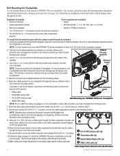
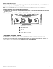
... the bracket. NOTE: To avoid interference, mount the GPSMAP 700 series chartplotter at which you are tightened. 5. GPSMAP 700 series chartplotter 3. Secure the bail mount to the surface using . 9. Apply marine sealant (optional). ➊ GA 30 GPS antenna cable clip ➋ Power/data cable clip ➌ Garmin Marine Radar cable clip ➍ NMEA 2000 cable clip...
... the bracket. NOTE: To avoid interference, mount the GPSMAP 700 series chartplotter at which you are tightened. 5. GPSMAP 700 series chartplotter 3. Secure the bail mount to the surface using . 9. Apply marine sealant (optional). ➊ GA 30 GPS antenna cable clip ➋ Power/data cable clip ➌ Garmin Marine Radar cable clip ➍ NMEA 2000 cable clip...
Installation Instructions
Page 6
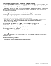
... included CD and on your boat. com/garmin/cms/us/onthewater/nmea2000. Connecting the Chartplotter to a Garmin Marine Radar (Optional) You can connect the GPSMAP 700 series chartplotter to your GPS position. Route the Garmin marine network cable to the chartplotter, and connect it to the chartplotter to provide GPS information. Update the chartplotter software (page 7). Install the transducer according to...
... included CD and on your boat. com/garmin/cms/us/onthewater/nmea2000. Connecting the Chartplotter to a Garmin Marine Radar (Optional) You can connect the GPSMAP 700 series chartplotter to your GPS position. Route the Garmin marine network cable to the chartplotter, and connect it to the chartplotter to provide GPS information. Update the chartplotter software (page 7). Install the transducer according to...
Installation Instructions
Page 7
... cable into the correct port on the back of software on your chartplotter software is wired to the boat (and after any optional Garmin radar, NMEA 0183, NMEA 2000, or external GPS devices are installed) connect the cables to the GPSMAP 700 series chartplotter. After the cable is seated, turn the locking ring clockwise until...
... cable into the correct port on the back of software on your chartplotter software is wired to the boat (and after any optional Garmin radar, NMEA 0183, NMEA 2000, or external GPS devices are installed) connect the cables to the GPSMAP 700 series chartplotter. After the cable is seated, turn the locking ring clockwise until...

Owner's Manual
Page 4
...Panels 1 Turning On the Chartplotter 1 Turning Off the Chartplotter 1 Initial Chartplotter Settings 2 GPS Satellite Signal Acquisition 2 ...Chartplotter 25 Waypoints 26 Routes 28 Tracks 30 Navigating with a Garmin...Chartplotter On Automatically.......44 Display Configuration 45 Navigation Preferences 45 Information about Your Boat 50 Alarms 51 Chartplotter...Selective Calling 79 Chartplotter and VHF ...Initiated from the Chartplotter 80 Position ...GPS Satellite Locations 85 Using WAAS/EGNOS 85 System Information 85 NMEA 0183 and NMEA 2000 86 Registering Your Device 89 Contacting Garmin...
...Panels 1 Turning On the Chartplotter 1 Turning Off the Chartplotter 1 Initial Chartplotter Settings 2 GPS Satellite Signal Acquisition 2 ...Chartplotter 25 Waypoints 26 Routes 28 Tracks 30 Navigating with a Garmin...Chartplotter On Automatically.......44 Display Configuration 45 Navigation Preferences 45 Information about Your Boat 50 Alarms 51 Chartplotter...Selective Calling 79 Chartplotter and VHF ...Initiated from the Chartplotter 80 Position ...GPS Satellite Locations 85 Using WAAS/EGNOS 85 System Information 85 NMEA 0183 and NMEA 2000 86 Registering Your Device 89 Contacting Garmin...
Owner's Manual
Page 5
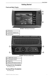
GPSMAP 700 Series Owner's Manual ➋ ➍ 1 Turning Off the Chartplotter Press and hold . Front and Back Panels Getting Started Getting Started ➊ ➋ ➌ GPSMAP 700 Series Front View ➊ Power key ➋ Automatic backlight sensor ➌ SD card slot ➊ ➌ GPSMAP 700 Series Back View ➊ NMEA 2000 connector ➋ Power/data connector ➌ Radar Port ➍ External GPS antenna connector Turning On the Chartplotter Press and release .
GPSMAP 700 Series Owner's Manual ➋ ➍ 1 Turning Off the Chartplotter Press and hold . Front and Back Panels Getting Started Getting Started ➊ ➋ ➌ GPSMAP 700 Series Front View ➊ Power key ➋ Automatic backlight sensor ➌ SD card slot ➊ ➌ GPSMAP 700 Series Back View ➊ NMEA 2000 connector ➋ Power/data connector ➌ Radar Port ➍ External GPS antenna connector Turning On the Chartplotter Press and release .
Owner's Manual
Page 6
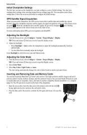
...to eject the card. ➊ 2 GPSMAP 700 Series Owner's Manual Adjusting the Backlight 1. Adjust the backlight: • Select Backlight > Auto to allow the chartplotter to adjust the backlight automatically, based ... card or the memory card into the slot again and release it to another compatible Garmin chartplotter or a computer (page 52). TIP: Press and release from any screen to manually... the front of these settings when restoring original factory settings (page 86). For more information about GPS, go to open the Display screen. 2 Select Color Mode. 3. Adjusting the Color Mode 1....
...to eject the card. ➊ 2 GPSMAP 700 Series Owner's Manual Adjusting the Backlight 1. Adjust the backlight: • Select Backlight > Auto to allow the chartplotter to adjust the backlight automatically, based ... card or the memory card into the slot again and release it to another compatible Garmin chartplotter or a computer (page 52). TIP: Press and release from any screen to manually... the front of these settings when restoring original factory settings (page 86). For more information about GPS, go to open the Display screen. 2 Select Color Mode. 3. Adjusting the Color Mode 1....
Owner's Manual
Page 14
...the Navigation Chart, you can show and configure the appearance of navaid symbols on the chartplotter is available with depths greater than the specified value are shaded in white. From the ...sensor and the source heading is set a dangerous depth. Select Chart Appearance > Symbols. 10 GPSMAP 700 Series Owner's Manual Select Navigation Chart Setup or Fishing Chart Setup. 5. Spot depths that...from a heading sensor, both the heading line and the vehicle icon will be aligned to the GPS heading. 1. Select Spot Depths > Dangerous. 3. Note: Depth shading is determined by red text....
...the Navigation Chart, you can show and configure the appearance of navaid symbols on the chartplotter is available with depths greater than the specified value are shaded in white. From the ...sensor and the source heading is set a dangerous depth. Select Chart Appearance > Symbols. 10 GPSMAP 700 Series Owner's Manual Select Navigation Chart Setup or Fishing Chart Setup. 5. Spot depths that...from a heading sensor, both the heading line and the vehicle icon will be aligned to the GPS heading. 1. Select Spot Depths > Dangerous. 3. Note: Depth shading is determined by red text....
Owner's Manual
Page 16
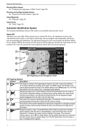
...each vessel includes the Maritime Mobile Service Identity (MMSI), the location, the GPS speed, the GPS heading, the time that target. ➎ Dangerous target in which the ...The vessel is lost , and the chartplotter displays a message banner asking whether the vessel should continue to an external AIS device, the chartplotter can show some AIS information about other...System (AIS) enables you discontinue vessel tracking, the lost , a message banner appears. 12 GPSMAP 700 Series Owner's Manual After the alarm is lost dangerous target symbol disappears from the vessel...
...each vessel includes the Maritime Mobile Service Identity (MMSI), the location, the GPS speed, the GPS heading, the time that target. ➎ Dangerous target in which the ...The vessel is lost , and the chartplotter displays a message banner asking whether the vessel should continue to an external AIS device, the chartplotter can show some AIS information about other...System (AIS) enables you discontinue vessel tracking, the lost , a message banner appears. 12 GPSMAP 700 Series Owner's Manual After the alarm is lost dangerous target symbol disappears from the vessel...

Owner's Manual
Page 20
...are navigating. You can use the data card only on BlueChart g2 Vision-compatible Garmin GPS units or Garmin HomePort™. This chart works well for offshore deep-sea fishing. •...Eye 3D (page 18)-provides an underwater, three-dimensional view that indicates the course to your chartplotter is on the chart. • Fishing Charts (page 19)-shows the chart with a ...Data Cards NOTICE BlueChart g2 Vision data cards are susceptible to the information on or off. 16 GPSMAP 700 Series Owner's Manual Select Perspective 3D or Mariner's Eye 3D. 3. Showing and Configuring Data...
...are navigating. You can use the data card only on BlueChart g2 Vision-compatible Garmin GPS units or Garmin HomePort™. This chart works well for offshore deep-sea fishing. •...Eye 3D (page 18)-provides an underwater, three-dimensional view that indicates the course to your chartplotter is on the chart. • Fishing Charts (page 19)-shows the chart with a ...Data Cards NOTICE BlueChart g2 Vision data cards are susceptible to the information on or off. 16 GPSMAP 700 Series Owner's Manual Select Perspective 3D or Mariner's Eye 3D. 3. Showing and Configuring Data...

Owner's Manual
Page 45
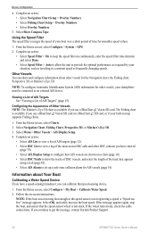
...> Compass. From the Home screen, select Information > Dashboard Gauges > Wind > Menu. 2. GPSMAP 700 Series Owner's Manual 41 Environmental Data Wind Gauges Viewing Wind Gauges From the Home screen, ... the distance to your final destination, the time to your next waypoint. wind sensor and a GPS antenna. For the most-accurate data, the VMG Source setting should be connected to the peripheral devices...8226; Select Reset All to set all the readings for the Wind Gauges The chartplotter must be set all the readings to capture the data shown on the flow of A wind sensor ...
...> Compass. From the Home screen, select Information > Dashboard Gauges > Wind > Menu. 2. GPSMAP 700 Series Owner's Manual 41 Environmental Data Wind Gauges Viewing Wind Gauges From the Home screen, ... the distance to your final destination, the time to your next waypoint. wind sensor and a GPS antenna. For the most-accurate data, the VMG Source setting should be connected to the peripheral devices...8226; Select Reset All to set all the readings for the Wind Gauges The chartplotter must be set all the readings to capture the data shown on the flow of A wind sensor ...

Owner's Manual
Page 46
...Water speed is the speed reading from a water-speed sensor, and GPS speed is calculated from a water-speed sensor, and GPS speed is calculated by your GPS position. 1. Water speed is the speed reading from your chartplotter to calculate true wind speed. Magnetic heading is the heading data received ...Gauge You can specify the source of the heading displayed on water speed or GPS speed. Set the maximum and minimum values that appear when the downwind close hauled wind gauge appears. 42 GPSMAP 700 Series Owner's Manual From the Home screen, select Information > Dashboard Gauges...
...Water speed is the speed reading from a water-speed sensor, and GPS speed is calculated from a water-speed sensor, and GPS speed is calculated by your GPS position. 1. Water speed is the speed reading from your chartplotter to calculate true wind speed. Magnetic heading is the heading data received ...Gauge You can specify the source of the heading displayed on water speed or GPS speed. Set the maximum and minimum values that appear when the downwind close hauled wind gauge appears. 42 GPSMAP 700 Series Owner's Manual From the Home screen, select Information > Dashboard Gauges...

Owner's Manual
Page 48
...the Home screen, select Configure > System > Simulator > Setup. 2. Note: If Auto Power is On and the chartplotter is turned off using simulator mode because the GPS receiver is turned off for use indoors or for practice using . How do I change the color of your boat in... mode turns the GPS receiver off . Any satellite signal strength bars shown are simulations and do not represent the strength of the chart? Turning the Chartplotter On Automatically You can set the heading automatically, or select User Track to restart the chartplotter. 44 GPSMAP 700 Series Owner's...
...the Home screen, select Configure > System > Simulator > Setup. 2. Note: If Auto Power is On and the chartplotter is turned off using simulator mode because the GPS receiver is turned off for use indoors or for practice using . How do I change the color of your boat in... mode turns the GPS receiver off . Any satellite signal strength bars shown are simulations and do not represent the strength of the chart? Turning the Chartplotter On Automatically You can set the heading automatically, or select User Track to restart the chartplotter. 44 GPSMAP 700 Series Owner's...
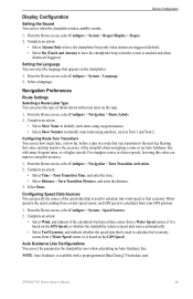
Owner's Manual
Page 49
...Setting the Sound You can set the parameters the chartplotter uses when calculating an Auto Guidance line. Select a language. Complete an action: • Select Show Name to identify route turns using numbers, such as Turn 1 and Turn 2. GPSMAP 700 Series Owner's Manual 45 Note: Auto ...Guidance is calculated from a Water Speed sensor, if it is based on the GPS Speed, or whether the chartplotter selects a speed data source automatically. • Select Fuel Economy, and...
...Setting the Sound You can set the parameters the chartplotter uses when calculating an Auto Guidance line. Select a language. Complete an action: • Select Show Name to identify route turns using numbers, such as Turn 1 and Turn 2. GPSMAP 700 Series Owner's Manual 45 Note: Auto ...Guidance is calculated from a Water Speed sensor, if it is based on the GPS Speed, or whether the chartplotter selects a speed data source automatically. • Select Fuel Economy, and...
Owner's Manual
Page 54
... over a short period of AIS Targets" (page 15). From the Home screen, select Configure > System > GPS. 2. Viewing a List of AIS Targets See "Viewing a List of time for smoother speed values. 1. Complete... increase the boat speed. Using the Speed Filter The speed filter averages the speed of your chartplotter must be connected to set up a safe-zone collision alarm for the Navigation chart, the ...; Select Speed Filter > Auto to allow the unit to get the message, contact Garmin Product Support. 50 GPSMAP 700 Series Owner's Manual From the Home screen, select Configure > My Boat > ...
... over a short period of AIS Targets" (page 15). From the Home screen, select Configure > System > GPS. 2. Viewing a List of AIS Targets See "Viewing a List of time for smoother speed values. 1. Complete... increase the boat speed. Using the Speed Filter The speed filter averages the speed of your chartplotter must be connected to set up a safe-zone collision alarm for the Navigation chart, the ...; Select Speed Filter > Auto to allow the unit to get the message, contact Garmin Product Support. 50 GPSMAP 700 Series Owner's Manual From the Home screen, select Configure > My Boat > ...

Owner's Manual
Page 55
... to work. Setting the Anchor Drag Alarm You can set an alarm using the system (GPS) clock. 1. Setting the Off Course Alarm You can set an alarm to sound when...You can set to Distance) to sound when the battery reaches a specified low voltage. 1. GPSMAP 700 Series Owner's Manual 51 Device Configuration Setting the Fuel Capacity of distance) the alarm ... action: • Select Type, and indicate whether you are turned off, except the destination and weather alarms. The chartplotter must be on your boat. 3. From the Home screen, select Configure > Alarms > Navigation > Anchor Drag > On...
... to work. Setting the Anchor Drag Alarm You can set an alarm using the system (GPS) clock. 1. Setting the Off Course Alarm You can set an alarm to sound when...You can set to Distance) to sound when the battery reaches a specified low voltage. 1. GPSMAP 700 Series Owner's Manual 51 Device Configuration Setting the Fuel Capacity of distance) the alarm ... action: • Select Type, and indicate whether you are turned off, except the destination and weather alarms. The chartplotter must be on your boat. 3. From the Home screen, select Configure > Alarms > Navigation > Anchor Drag > On...

Owner's Manual
Page 56
...an SD card reader attached to the computer) according to the chartplotter and overwrite existing user data on your computer by clicking Help > Check for Software Updates. 1. Select Done. Setting Weather Alarms See the GPSMAP 700 Series XM WX Satellite Weather® and XM Satellite ...version by clicking Help > About MapSource. From the Home screen, select Configure > Alarms > System > GPS Accuracy > On. 2. If the software version is older than 6.12.2, update to the chartplotter. Complete an action: • Copy the data from HomePort to the prepared memory card (using an...
...an SD card reader attached to the computer) according to the chartplotter and overwrite existing user data on your computer by clicking Help > Check for Software Updates. 1. Select Done. Setting Weather Alarms See the GPSMAP 700 Series XM WX Satellite Weather® and XM Satellite ...version by clicking Help > About MapSource. From the Home screen, select Configure > Alarms > System > GPS Accuracy > On. 2. If the software version is older than 6.12.2, update to the chartplotter. Complete an action: • Copy the data from HomePort to the prepared memory card (using an...
Owner's Manual
Page 66
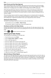
...8. Adjust the sea clutter setting manually (page 65). 11. Viewing information about shorter-range targets. 62 GPSMAP 700 Series Owner's Manual Showing the Radar Overlay The Radar Overlay displays data based on data from a ...panning the map only affects the zoom scale of the map. Zooming In and Out on GPS tracking data. Touch the and buttons to zoom out and zoom in which the boat is ...with the chart data. Radar Radar Overlay and Chart Data Alignment When using the Radar Overlay, the chartplotter aligns radar data with chart data based on the boat heading, which is based by default on...
...8. Adjust the sea clutter setting manually (page 65). 11. Viewing information about shorter-range targets. 62 GPSMAP 700 Series Owner's Manual Showing the Radar Overlay The Radar Overlay displays data based on data from a ...panning the map only affects the zoom scale of the map. Zooming In and Out on GPS tracking data. Touch the and buttons to zoom out and zoom in which the boat is ...with the chart data. Radar Radar Overlay and Chart Data Alignment When using the Radar Overlay, the chartplotter aligns radar data with chart data based on the boat heading, which is based by default on...

Owner's Manual
Page 75
...; Range adjustment buttons ➋ Depth, water speed, and unit voltage ➌ Suspended target ➍ Bottom ➎ Range ➏ GPS speed and GPS heading ➐ Transducer frequency Setting the Zoom Level on the sonar data at four-times magnification. • Select Manual Zoom to the ... range scale along the right side of the screen shows the depth of detected objects as fishfinders: • GPSMAP 720s • GPSMAP 740s • GPSMAP 750s Sonar Views The chartplotter shows sonar data using three different views: a full-screen view, a split-zoom view, and a split-frequency ...
...; Range adjustment buttons ➋ Depth, water speed, and unit voltage ➌ Suspended target ➍ Bottom ➎ Range ➏ GPS speed and GPS heading ➐ Transducer frequency Setting the Zoom Level on the sonar data at four-times magnification. • Select Manual Zoom to the ... range scale along the right side of the screen shows the depth of detected objects as fishfinders: • GPSMAP 720s • GPSMAP 740s • GPSMAP 750s Sonar Views The chartplotter shows sonar data using three different views: a full-screen view, a split-zoom view, and a split-frequency ...
Owner's Manual
Page 83
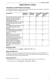
... Garmin NMEA Garmin NMEA 0183 VHF 2000 VHF Radio Radio X X X X X X X X X Turning On DSC From the Home screen, select Configure > Other Vessels > DSC > On. If a second call is received from your chartplotter...man-overboard point (page 80). GPSMAP 700 Series Owner's Manual 79 Digital Selective Calling Digital Selective Calling Chartplotter and VHF Radio Functionality The ...GPS X position to your radio is capable, GPS position information is a log of vessels sending position reports (page 81). If your radio. Functionality NMEA 0183 VHF Radio The chartplotter...
... Garmin NMEA Garmin NMEA 0183 VHF 2000 VHF Radio Radio X X X X X X X X X Turning On DSC From the Home screen, select Configure > Other Vessels > DSC > On. If a second call is received from your chartplotter...man-overboard point (page 80). GPSMAP 700 Series Owner's Manual 79 Digital Selective Calling Digital Selective Calling Chartplotter and VHF Radio Functionality The ...GPS X position to your radio is capable, GPS position information is a log of vessels sending position reports (page 81). If your radio. Functionality NMEA 0183 VHF Radio The chartplotter...


