
Owner's Manual
Page 5
...® is a registered trademark of Jeppesen, Inc. Copyright © 2008, 2012 Garmin Ltd. Garmin®,GPSMAP®, FliteCharts® and SafeTaxi® are registered trademarks of System Software version 6.20 or later. NavData® is strictly prohibited. This manual reflects the operation of Garmin Ltd. Printed in any storage medium, for any revision hereto is...
...® is a registered trademark of Jeppesen, Inc. Copyright © 2008, 2012 Garmin Ltd. Garmin®,GPSMAP®, FliteCharts® and SafeTaxi® are registered trademarks of System Software version 6.20 or later. NavData® is strictly prohibited. This manual reflects the operation of Garmin Ltd. Printed in any storage medium, for any revision hereto is...

Owner's Manual
Page 6
...for vertical navigation. Terrain data is geometric height above Mean Sea Level and could vary significantly from the altitude displayed by GPSMAP 695/696 GPS receiver is obtained from the instruments in order to use outdated database information. WARNING: The altitude calculated by pressure ...derived data and may differ from third party sources. GPS altitude should not be used in the GPSMAP 695/696 must NOT be updated regularly in the aircraft. WARNING: Do not use this unit for appropriate minimum clearance altitudes. Garmin GPSMAP 695/696 Owner's Manual 190-00919-00 Rev.
...for vertical navigation. Terrain data is geometric height above Mean Sea Level and could vary significantly from the altitude displayed by GPSMAP 695/696 GPS receiver is obtained from the instruments in order to use outdated database information. WARNING: The altitude calculated by pressure ...derived data and may differ from third party sources. GPS altitude should not be used in the GPSMAP 695/696 must NOT be updated regularly in the aircraft. WARNING: Do not use this unit for appropriate minimum clearance altitudes. Garmin GPSMAP 695/696 Owner's Manual 190-00919-00 Rev.

Owner's Manual
Page 7
... all GPS equipment. Due to accurately depict all NAVAIDs, information presented by the GPSMAP 695/696 can be misused or misinterpreted and, therefore, become unsafe. 190-00919-00 Rev. G Garmin GPSMAP 695/696 Owner's Manual Warnings, Cautions & Notes WARNING: Do not rely solely upon the display of ... information shown by the data link weather product may be significantly older than the indicated weather product age. Portions of the Garmin GPSMAP 695/696 utilize GPS as with in , near, or around areas of traffic information for collision avoidance maneuvering. WARNING: Do not ...
... all GPS equipment. Due to accurately depict all NAVAIDs, information presented by the GPSMAP 695/696 can be misused or misinterpreted and, therefore, become unsafe. 190-00919-00 Rev. G Garmin GPSMAP 695/696 Owner's Manual Warnings, Cautions & Notes WARNING: Do not rely solely upon the display of ... information shown by the data link weather product may be significantly older than the indicated weather product age. Portions of the Garmin GPSMAP 695/696 utilize GPS as with in , near, or around areas of traffic information for collision avoidance maneuvering. WARNING: Do not ...

Owner's Manual
Page 8
... navigation sources, including the information from the actual equipment. G For safety purposes, always resolve any userserviceable parts. Garmin GPSMAP 695/696 Owner's Manual 190-00919-00 Rev. Warnings, Cautions & Notes WARNING: To reduce the risk of unsafe operation, carefully review ...and understand all aspects of functional integrity. NOTE: The Garmin GPSMAP 695/696 has a very high degree of the GPSMAP 695/696 User's Manual documentation and the Pilot's Operating Handbook for anti-reflective coatings. Both the FAA Advisory Circular, ...
... navigation sources, including the information from the actual equipment. G For safety purposes, always resolve any userserviceable parts. Garmin GPSMAP 695/696 Owner's Manual 190-00919-00 Rev. Warnings, Cautions & Notes WARNING: To reduce the risk of unsafe operation, carefully review ...and understand all aspects of functional integrity. NOTE: The Garmin GPSMAP 695/696 has a very high degree of the GPSMAP 695/696 User's Manual documentation and the Pilot's Operating Handbook for anti-reflective coatings. Both the FAA Advisory Circular, ...

Owner's Manual
Page 9
...This product, its packaging, and its components contain chemicals known to the State of California to our web site at www.garmin.com/prop65. This notice is installed. 190-00919-00 Rev. Warnings, Cautions & Notes NOTE: This device complies with California...Flight Restriction TFR information. Always confirm TFR information through official sources such as Flight Service Stations of the FCC Rules. G Garmin GPSMAP 695/696 Owner's Manual Garmin accurately processes and cross-validates the data, but does not guarantee the accuracy and completeness of polarized eyewear may cause undesired...
...This product, its packaging, and its components contain chemicals known to the State of California to our web site at www.garmin.com/prop65. This notice is installed. 190-00919-00 Rev. Warnings, Cautions & Notes NOTE: This device complies with California...Flight Restriction TFR information. Always confirm TFR information through official sources such as Flight Service Stations of the FCC Rules. G Garmin GPSMAP 695/696 Owner's Manual Garmin accurately processes and cross-validates the data, but does not guarantee the accuracy and completeness of polarized eyewear may cause undesired...

Owner's Manual
Page 10
...-4.00 changes: • Added user-created checklists. • Added support to export user waypoints and track logs to the flight plan pages. RR-10 Garmin GPSMAP 695/696 Owner's Manual 190-00919-00 Rev. Change Summary Rev Date D November, 2008 E March, 2012 Production Release. Description System Software Version 2.00 - 2.20 changes: • Added separate...
...-4.00 changes: • Added user-created checklists. • Added support to export user waypoints and track logs to the flight plan pages. RR-10 Garmin GPSMAP 695/696 Owner's Manual 190-00919-00 Rev. Change Summary Rev Date D November, 2008 E March, 2012 Production Release. Description System Software Version 2.00 - 2.20 changes: • Added separate...

Owner's Manual
Page 11
... screenshot utility to be activated when Menu key is pressed and held. • Changed XTK data fields display to more closely resemble G3X presentation. G Garmin GPSMAP 695/696 Owner's Manual RR-11 System Software Version 4.70-4.80 changes: • Added display setup option to just Airport Directory where applicable. • Updated System Messages. •...
... screenshot utility to be activated when Menu key is pressed and held. • Changed XTK data fields display to more closely resemble G3X presentation. G Garmin GPSMAP 695/696 Owner's Manual RR-11 System Software Version 4.70-4.80 changes: • Added display setup option to just Airport Directory where applicable. • Updated System Messages. •...

Owner's Manual
Page 12
Rev Date F July, 2012 Description System Software Version 4.90-5.00 changes: • Correct Disclaimer page database expiration date information • Correct missing 'Mark' waypoint operation (695 units only) System Software Version 5.00-6.00 changes: • Added GDL 39 support G August, 2012 System Software Version 6.00-6.20 changes: • Added TargetTrend™ • Added GDL 39 Serial Pass-Through RR-12 Garmin GPSMAP 695/696 Owner's Manual 190-00919-00 Rev. G
Rev Date F July, 2012 Description System Software Version 4.90-5.00 changes: • Correct Disclaimer page database expiration date information • Correct missing 'Mark' waypoint operation (695 units only) System Software Version 5.00-6.00 changes: • Added GDL 39 support G August, 2012 System Software Version 6.00-6.20 changes: • Added TargetTrend™ • Added GDL 39 Serial Pass-Through RR-12 Garmin GPSMAP 695/696 Owner's Manual 190-00919-00 Rev. G

Owner's Manual
Page 13
G Garmin GPSMAP 695/696 Owner's Manual i Table of Contents SECTION 1 OVERVIEW...1 1.1 Unit Overview...1 Battery Care and Charging...2 Turning the Unit On/Off...4 GPS Receiver Status...6 1.2 GPSMAP 695/696 Controls 8 1.3 Accessing System Functionality 10 Menus...10 Data Entry...11 Pages...13 Main Page Softkeys...18 ... 2.1 Introduction...35 Data Bar Fields...36 Compass Arc...38 2.2 Panel...40 Changing the CDI Scale...41 Setting the Bug Indicator...42 Manually Setting a Course 42 2.3 Vertical Navigation (VNAV 43 Using the VNAV Feature...44 2.4 Using Map Displays...46 Map Orientation...47 Map...
G Garmin GPSMAP 695/696 Owner's Manual i Table of Contents SECTION 1 OVERVIEW...1 1.1 Unit Overview...1 Battery Care and Charging...2 Turning the Unit On/Off...4 GPS Receiver Status...6 1.2 GPSMAP 695/696 Controls 8 1.3 Accessing System Functionality 10 Menus...10 Data Entry...11 Pages...13 Main Page Softkeys...18 ... 2.1 Introduction...35 Data Bar Fields...36 Compass Arc...38 2.2 Panel...40 Changing the CDI Scale...41 Setting the Bug Indicator...42 Manually Setting a Course 42 2.3 Vertical Navigation (VNAV 43 Using the VNAV Feature...44 2.4 Using Map Displays...46 Map Orientation...47 Map...

Owner's Manual
Page 14
......96 Selecting an Approach...97 Activating Vectors-to-Final 100 3.6 Trip Planning...101 SECTION 4 HAZARD AVOIDANCE 103 4.1 Weather Information...103 SiriusXM Weather (696 only 104 Data Link weather (FIS-B 124 4.2 Terrain...141 Terrain Information...142 Obstacle Information...142 Terrain and Obstacle Color Code 143 ii Garmin GPSMAP 695/696 Owner's Manual 190-00919-00 Rev. G
......96 Selecting an Approach...97 Activating Vectors-to-Final 100 3.6 Trip Planning...101 SECTION 4 HAZARD AVOIDANCE 103 4.1 Weather Information...103 SiriusXM Weather (696 only 104 Data Link weather (FIS-B 124 4.2 Terrain...141 Terrain Information...142 Obstacle Information...142 Terrain and Obstacle Color Code 143 ii Garmin GPSMAP 695/696 Owner's Manual 190-00919-00 Rev. G
Owner's Manual
Page 15
G Garmin GPSMAP 695/696 Owner's Manual iii Table of Contents Terrain Settings...143 Terrain Alerts...146 4.3 Traffic Information ...148 Traffic Information Service (TIS-A 149 Data Link Traffic (GDL 39 ... 173 5.3 FliteCharts®...174 Chart Range...177 Aircraft Symbol...178 FliteCharts Cycle Number and Expiration Date 179 5.4 Airport Directory Data 180 5.5 SiriusXM Radio Entertainment (GPSMAP 696 182 Activating SiriusXM Satellite Radio Services 182 Using SiriusXM Radio...183 5.6 Electronic Checklists...188 5.7 Flight Data Logging...188 SECTION 6 APPENDICES...189 Messages, Alerts &...
G Garmin GPSMAP 695/696 Owner's Manual iii Table of Contents Terrain Settings...143 Terrain Alerts...146 4.3 Traffic Information ...148 Traffic Information Service (TIS-A 149 Data Link Traffic (GDL 39 ... 173 5.3 FliteCharts®...174 Chart Range...177 Aircraft Symbol...178 FliteCharts Cycle Number and Expiration Date 179 5.4 Airport Directory Data 180 5.5 SiriusXM Radio Entertainment (GPSMAP 696 182 Activating SiriusXM Satellite Radio Services 182 Using SiriusXM Radio...183 5.6 Electronic Checklists...188 5.7 Flight Data Logging...188 SECTION 6 APPENDICES...189 Messages, Alerts &...
Owner's Manual
Page 16
... to a Computer 209 Information about USB Drivers 210 Using xImage for Customized Waypoint Symbols 210 Connecting the GXM 40 Antenna (GPSMAP 696 210 Interfacing...211 Connecting to a GTX 330 Mode S Transponder 213 Connecting to a GDL 39...214 Using an external GPS...Contact Garmin...255 Software License Agreement 255 Limited Warranty...255 AOPA Airport Directory Notice 256 AC-U-KWIK LICENSE AGREEMENT 256 Weather Data Warranty...257 SiriusXM Satellite Radio Service Agreement 258 FCC Compliance...258 Industry Canada Compliance 258 Index...Index-1 iv Garmin GPSMAP 695/696 Owner's Manual ...
... to a Computer 209 Information about USB Drivers 210 Using xImage for Customized Waypoint Symbols 210 Connecting the GXM 40 Antenna (GPSMAP 696 210 Interfacing...211 Connecting to a GTX 330 Mode S Transponder 213 Connecting to a GDL 39...214 Using an external GPS...Contact Garmin...255 Software License Agreement 255 Limited Warranty...255 AOPA Airport Directory Notice 256 AC-U-KWIK LICENSE AGREEMENT 256 Weather Data Warranty...257 SiriusXM Satellite Radio Service Agreement 258 FCC Compliance...258 Industry Canada Compliance 258 Index...Index-1 iv Garmin GPSMAP 695/696 Owner's Manual ...
Owner's Manual
Page 17
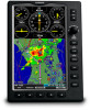
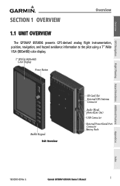
Overview GPS Navigation Flight Planning Hazard Avoidance Additional Features SECTION 1 OVERVIEW Overview 1.1 UNIT OVERVIEW The GPSMAP 695/696 presents GPS-derived analog flight instrumentation, position, navigation, and hazard avoidance information to the pilot using a 7" Wide VGA (800x480) color display. 7" WVGA (800x480) Color Display ... Card Slot External GPS Antenna Connector Audio (Headphones/Line Out) USB Connector External Power/Serial Port Connector Battery Pack Appendices Index 190-00919-00 Rev. G Garmin GPSMAP 695/696 Owner's Manual 1
Overview GPS Navigation Flight Planning Hazard Avoidance Additional Features SECTION 1 OVERVIEW Overview 1.1 UNIT OVERVIEW The GPSMAP 695/696 presents GPS-derived analog flight instrumentation, position, navigation, and hazard avoidance information to the pilot using a 7" Wide VGA (800x480) color display. 7" WVGA (800x480) Color Display ... Card Slot External GPS Antenna Connector Audio (Headphones/Line Out) USB Connector External Power/Serial Port Connector Battery Pack Appendices Index 190-00919-00 Rev. G Garmin GPSMAP 695/696 Owner's Manual 1
Owner's Manual
Page 18
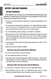
Using another battery presents a risk of the unit. • Only replace with a Garmin Nickel Metal Hydride battery pack. Additional User-replaceable Battery Warnings • Do not use a sharp object to remove the battery. • Do not recharge ... unit exposed to a heat source or in a high temperature location, such as a waste electronics treatment facility, to have the battery removed and recycled. 2 Garmin GPSMAP 695/696 Owner's Manual 190-00919-00 Rev. When storing the unit for a limited length of time (less than 30 days), store within the following temperature range: -68...
Using another battery presents a risk of the unit. • Only replace with a Garmin Nickel Metal Hydride battery pack. Additional User-replaceable Battery Warnings • Do not use a sharp object to remove the battery. • Do not recharge ... unit exposed to a heat source or in a high temperature location, such as a waste electronics treatment facility, to have the battery removed and recycled. 2 Garmin GPSMAP 695/696 Owner's Manual 190-00919-00 Rev. When storing the unit for a limited length of time (less than 30 days), store within the following temperature range: -68...
Owner's Manual
Page 19
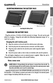
... unit is in use for full operation. When the unit in use . 190-00919-00 Rev. If the battery is applied. G Garmin GPSMAP 695/696 Owner's Manual 3 Appendices Index Charge the unit within the following temperature range: 32° to 104°F (0° to charge. The unit begins... charging as soon as external power is present and needs to the GPSMAP 695/696 automatically turns on the aircraft's battery. Using charge mode ...
... unit is in use for full operation. When the unit in use . 190-00919-00 Rev. If the battery is applied. G Garmin GPSMAP 695/696 Owner's Manual 3 Appendices Index Charge the unit within the following temperature range: 32° to 104°F (0° to charge. The unit begins... charging as soon as external power is present and needs to the GPSMAP 695/696 automatically turns on the aircraft's battery. Using charge mode ...

Owner's Manual
Page 20
TURNING THE UNIT ON/OFF Press and hold the POWER Button. The GPSMAP 695/696 retains the backlighting settings between power cycles. The power button can be used to quickly set to an external power supply. Overview GPS Navigation ...not suitable for the current ambient lighting. A momentary press of the power button changes the backlight level to "find itself" anywhere in the world. 4 Garmin GPSMAP 695/696 Owner's Manual 190-00919-00 Rev. For more information on , the receiver must collect satellite data and establish its present location. To ensure proper initialization, the...
TURNING THE UNIT ON/OFF Press and hold the POWER Button. The GPSMAP 695/696 retains the backlighting settings between power cycles. The power button can be used to quickly set to an external power supply. Overview GPS Navigation ...not suitable for the current ambient lighting. A momentary press of the power button changes the backlight level to "find itself" anywhere in the world. 4 Garmin GPSMAP 695/696 Owner's Manual 190-00919-00 Rev. For more information on , the receiver must collect satellite data and establish its present location. To ensure proper initialization, the...

Owner's Manual
Page 21
... this information. 190-00919-00 Rev. Data link Weather Advisory Press the ENT Key to ensure that no databases have expired), the pilot is displayed. G Garmin GPSMAP 695/696 Owner's Manual 5 Index Press the ENT Key to acknowledge a data link weather advisory.
... this information. 190-00919-00 Rev. Data link Weather Advisory Press the ENT Key to ensure that no databases have expired), the pilot is displayed. G Garmin GPSMAP 695/696 Owner's Manual 5 Index Press the ENT Key to acknowledge a data link weather advisory.

Owner's Manual
Page 22
... or 3D fix Constellation Diagram PRN Number 45° Above Horizon Horizon Receiver Status Signal Strength Bar PRN Number GPS Status (Info Page) Appendices Index 6 Garmin GPSMAP 695/696 Owner's Manual 190-00919-00 Rev.
... or 3D fix Constellation Diagram PRN Number 45° Above Horizon Horizon Receiver Status Signal Strength Bar PRN Number GPS Status (Info Page) Appendices Index 6 Garmin GPSMAP 695/696 Owner's Manual 190-00919-00 Rev.

Owner's Manual
Page 23
... satellite in view, with the appropriate satellite PRN number (01-32 or 33-64 for the GPS solution Appendices Index 190-00919-00 Rev. G Garmin GPSMAP 695/696 Owner's Manual 7 When the receiver is shown in the process of satellites have been acquired for the indicated satellite - Gray bar-Receiver has collected the necessary...
... satellite in view, with the appropriate satellite PRN number (01-32 or 33-64 for the GPS solution Appendices Index 190-00919-00 Rev. G Garmin GPSMAP 695/696 Owner's Manual 7 When the receiver is shown in the process of satellites have been acquired for the indicated satellite - Gray bar-Receiver has collected the necessary...

Owner's Manual
Page 24
G Index Overview GPS Navigation Overview 1.2 GPSMAP 695/696 CONTROLS The GPSMAP 695/696 controls have been designed to simplify operation of the system and minimize workload and the time required to access sophisticated functionality. 1 2 3 4 5 6 7 8 9 Additional Features Hazard Avoidance ... change the selected value within the highlighted field Move the FMS Joystick to highlight fields or move the map pointer when interacting with the page Garmin GPSMAP 695/696 Owner's Manual 190-00919-00 Rev.
G Index Overview GPS Navigation Overview 1.2 GPSMAP 695/696 CONTROLS The GPSMAP 695/696 controls have been designed to simplify operation of the system and minimize workload and the time required to access sophisticated functionality. 1 2 3 4 5 6 7 8 9 Additional Features Hazard Avoidance ... change the selected value within the highlighted field Move the FMS Joystick to highlight fields or move the map pointer when interacting with the page Garmin GPSMAP 695/696 Owner's Manual 190-00919-00 Rev.


