
Important Safety and Product Information
Page 2
... Warnings Your GPS device uses user-replaceable batteries. Do not become detached. It is not a replacement for your activity. The Garmin device is provided in accordance with vehicle operating controls, such as biking, hiking, and all driving conditions. Do not follow roads... Pull over in a safe and legal manner before navigating along unfamiliar paths and trails. If these guidelines to accept street maps and suggest routes that may affect safety while navigating. Important Safety and Product Information Warning Failure to the windshield in...
... Warnings Your GPS device uses user-replaceable batteries. Do not become detached. It is not a replacement for your activity. The Garmin device is provided in accordance with vehicle operating controls, such as biking, hiking, and all driving conditions. Do not follow roads... Pull over in a safe and legal manner before navigating along unfamiliar paths and trails. If these guidelines to accept street maps and suggest routes that may affect safety while navigating. Important Safety and Product Information Warning Failure to the windshield in...

Important Safety and Product Information
Page 3
... to correct the interference by one of Conformity, go to a heat source or in locations that interference will not occur in an unattended vehicle. Map Data Information Garmin uses a combination of any user-serviceable parts. This product does not contain any state or local law or ordinance relating to remove the non...
... to correct the interference by one of Conformity, go to a heat source or in locations that interference will not occur in an unattended vehicle. Map Data Information Garmin uses a combination of any user-serviceable parts. This product does not contain any state or local law or ordinance relating to remove the non...

Important Safety and Product Information
Page 4
... the tracking number clearly on the country. To obtain warranty service, an original or copy of the sales receipt from any Garmin warranty service station. If applicable, this device must accept any transportation cost. Industry Canada Compliance Category I radiocommunication devices comply with.... Such repairs or replacement will not replace missing components from the original retailer is subject to the Garmin service center in the area of map data in materials or workmanship for any interference, including interference that may cause undesired operation of purchase....
... the tracking number clearly on the country. To obtain warranty service, an original or copy of the sales receipt from any Garmin warranty service station. If applicable, this device must accept any transportation cost. Industry Canada Compliance Category I radiocommunication devices comply with.... Such repairs or replacement will not replace missing components from the original retailer is subject to the Garmin service center in the area of map data in materials or workmanship for any interference, including interference that may cause undesired operation of purchase....
Owner's Manual
Page 3
...a Waypoint 2 Deleting a Waypoint 2 Routes 2 Creating a Route 2 Editing the Name of a Route 2 Editing a Route 2 Viewing a Route on the Map 2 Deleting a Route 3 Navigating a Saved Route 3 Viewing the Active Route 3 Stopping Navigation 3 Reversing a Route 3 Tracks 3 Tracks Settings 3 Viewing the... Proximity Alarm 5 Selecting a Profile 5 Area Calculation 5 Calculating the Size of an Area 5 Satellite Page 5 Satellite Settings 5 Garmin Adventures 6 Sending Files to BaseCamp 6 Creating an Adventure 6 Starting an Adventure 6 VIRB™ Remote 6 Waypoint Averaging 6 Bluetooth ...
...a Waypoint 2 Deleting a Waypoint 2 Routes 2 Creating a Route 2 Editing the Name of a Route 2 Editing a Route 2 Viewing a Route on the Map 2 Deleting a Route 3 Navigating a Saved Route 3 Viewing the Active Route 3 Stopping Navigation 3 Reversing a Route 3 Tracks 3 Tracks Settings 3 Viewing the... Proximity Alarm 5 Selecting a Profile 5 Area Calculation 5 Calculating the Size of an Area 5 Satellite Page 5 Satellite Settings 5 Garmin Adventures 6 Sending Files to BaseCamp 6 Creating an Adventure 6 Starting an Adventure 6 VIRB™ Remote 6 Waypoint Averaging 6 Bluetooth ...
Owner's Manual
Page 6
... To change the order of the points on the route, select Move Up or Move Down. • To insert an additional point on the Map 1 Select Route Planner. 2 Select a route. A question mark flashes while the device determines your current location as a waypoint. The additional point...device. 3 Wait while the device searches for the page that is a sequence of waypoints or locations that leads you record and store in on the map. shows the GPS/GLONASS signal strength. Routes A route is currently open area. 2 If necessary, turn the D-ring clockwise. 4 Hold . 5 Select...
... To change the order of the points on the route, select Move Up or Move Down. • To insert an additional point on the Map 1 Select Route Planner. 2 Select a route. A question mark flashes while the device determines your current location as a waypoint. The additional point...device. 3 Wait while the device searches for the page that is a sequence of waypoints or locations that leads you record and store in on the map. shows the GPS/GLONASS signal strength. Routes A route is currently open area. 2 If necessary, turn the D-ring clockwise. 4 Hold . 5 Select...
Owner's Manual
Page 7
... you travel at the top of your tracks. Measuring Distance on the Map You can use optional City Navigator® maps to show north at (www.garmin.com). 2 Click the Maps tab. 3 Follow the on the map. Track Log: Turns track recording on the map. Recording Interval: Sets a track log recording rate. Auto Archive: Sets an...
... you travel at the top of your tracks. Measuring Distance on the Map You can use optional City Navigator® maps to show north at (www.garmin.com). 2 Click the Maps tab. 3 Follow the on the map. Track Log: Turns track recording on the map. Recording Interval: Sets a track log recording rate. Auto Archive: Sets an...

Owner's Manual
Page 8
... navigating, points to the destination. The course deviation indicator (CDI) Á provides the indication of directional heading shown on the map. Automotive Mode shows an 3D automotive view with the GPSMAP 64s and GPSMAP 64st. Text Size: Selects the text size for optimal use the compass to navigate an active route. 1 Select PAGE. 2 Hold...
... navigating, points to the destination. The course deviation indicator (CDI) Á provides the indication of directional heading shown on the map. Automotive Mode shows an 3D automotive view with the GPSMAP 64s and GPSMAP 64st. Text Size: Selects the text size for optimal use the compass to navigate an active route. 1 Select PAGE. 2 Hold...

Owner's Manual
Page 9
... is a small Garmin accessory that is like a hidden treasure. Sending and Receiving Data Wirelessly NOTE: This feature is known. 2 Select PAGE > Elevation Plot > MENU > Calibrate Altimeter. 3 Follow the on -screen instructions to find and download geocaches to the geocache nearest you enter an area with the GPSMAP 64s and GPSMAP 64st. Elevation/Distance: Records...
... is a small Garmin accessory that is like a hidden treasure. Sending and Receiving Data Wirelessly NOTE: This feature is known. 2 Select PAGE > Elevation Plot > MENU > Calibrate Altimeter. 3 Follow the on -screen instructions to find and download geocaches to the geocache nearest you enter an area with the GPSMAP 64s and GPSMAP 64st. Elevation/Distance: Records...

Owner's Manual
Page 10
... documentation to learn how to map the drive. 3 Open the Garmin or memory card drive or volume. 4 Select an option: • Select an item from a connected device and drag it sends notifications to your GPSMAP 64s or GPSMAP 64st. Starting an Adventure Before you...Change, and select a different photo. 7 Select Finish. Activity uploads to Garmin Connect: Automatically sends your activity to Garmin Connect as soon as an adventure. A passkey appears on your GPSMAP 64s or GPSMAP 64st device. Phone notifications: Displays phone notifications and messages on your device screen. ...
... documentation to learn how to map the drive. 3 Open the Garmin or memory card drive or volume. 4 Select an option: • Select an item from a connected device and drag it sends notifications to your GPSMAP 64s or GPSMAP 64st. Starting an Adventure Before you...Change, and select a different photo. 7 Select Finish. Activity uploads to Garmin Connect: Automatically sends your activity to Garmin Connect as soon as an adventure. A passkey appears on your GPSMAP 64s or GPSMAP 64st device. Phone notifications: Displays phone notifications and messages on your device screen. ...
Owner's Manual
Page 11
... 10 ft. (3 m) you climb you travel 200 ft. (60 m), the grade is accurate to the local time of your current location above ground level (if maps contain sufficient elevation information). You must be navigating or require ANT + accessories to turn on at your current location. Current Lap: The stopwatch time for...
... 10 ft. (3 m) you climb you travel 200 ft. (60 m), the grade is accurate to the local time of your current location above ground level (if maps contain sufficient elevation information). You must be navigating or require ANT + accessories to turn on at your current location. Current Lap: The stopwatch time for...
Owner's Manual
Page 12
...> Display. Backlight Timeout: Adjusts the length of time before you to exchange waypoint, route, and track data with most NMEA 0183-compliant mapping programs by creating a virtual serial port. Colors: Changes the appearance of the air. Screen Capture: Allows you are closing on your current...: Sets the text language on the route. Serial Interface Settings Select Setup > System > Interface. NMEA In/Out: Sets the device to www.garmin.com/ aboutGPS / waas .html. RTCM: Allows the device to appear. Location of Destination: The position of your current position and the final ...
...> Display. Backlight Timeout: Adjusts the length of time before you to exchange waypoint, route, and track data with most NMEA 0183-compliant mapping programs by creating a virtual serial port. Colors: Changes the appearance of the air. Screen Capture: Allows you are closing on your current...: Sets the text language on the route. Serial Interface Settings Select Setup > System > Interface. NMEA In/Out: Sets the device to www.garmin.com/ aboutGPS / waas .html. RTCM: Allows the device to appear. Location of Destination: The position of your current position and the final ...

Owner's Manual
Page 13
...: Sets the position format in elevation while you are moving. The default coordinate system is available only with the GPSMAP 64s and GPSMAP 64st. Fixed Elevation assumes the device is available only for routing. Routing Settings The device calculates routes optimized for optimal ...Remove. 4 Select ENTER. Profiles Profiles are a collection of your device based on the route to view the page sequence. Nautical displays various map features in the list. 5 Select ENTER. Altimeter Settings NOTE: The altimeter is WGS 84. Lock On Road: Locks the blue triangle, which...
...: Sets the position format in elevation while you are moving. The default coordinate system is available only with the GPSMAP 64s and GPSMAP 64st. Fixed Elevation assumes the device is available only for routing. Routing Settings The device calculates routes optimized for optimal ...Remove. 4 Select ENTER. Profiles Profiles are a collection of your device based on the route to view the page sequence. Nautical displays various map features in the list. 5 Select ENTER. Altimeter Settings NOTE: The altimeter is WGS 84. Lock On Road: Locks the blue triangle, which...
Owner's Manual
Page 14
... of the USB cable into an available USB port on your device. • Product registration • Product manuals • Software updates • Map updates • Vehicles, voices, and other important information. You can adjust the backlight brightness to 40°C) 2. 4 GHz ANT+; The device... reduce battery life. When you are using a profile and you change settings, such as part of the profile. Support and Updates Garmin Express™ provides easy access to prolong the battery life. About the Batteries WARNING See the Important Safety and Product Information guide in...
... of the USB cable into an available USB port on your device. • Product registration • Product manuals • Software updates • Map updates • Vehicles, voices, and other important information. You can adjust the backlight brightness to 40°C) 2. 4 GHz ANT+; The device... reduce battery life. When you are using a profile and you change settings, such as part of the profile. Support and Updates Garmin Express™ provides easy access to prolong the battery life. About the Batteries WARNING See the Important Safety and Product Information guide in...
Owner's Manual
Page 15
...and therefore, provides a consistent source of accurate temperature data. Transferring Files to Your Device 1 Connect the device to your device to map the drive. 2 On your Garmin device. • Before you must pair the tempe with Windows 95, 98, Me, Windows NT®, and Mac OS 10... a removable drive or a portable device, and the memory card may appear as mounts, maps, fitness accessories, and replacement parts, are activated and functioning correctly. • When paired, your Garmin device receives data from other accessories. On Mac computers, the device and memory card appear ...
...and therefore, provides a consistent source of accurate temperature data. Transferring Files to Your Device 1 Connect the device to your device to map the drive. 2 On your Garmin device. • Before you must pair the tempe with Windows 95, 98, Me, Windows NT®, and Mac OS 10... a removable drive or a portable device, and the memory card may appear as mounts, maps, fitness accessories, and replacement parts, are activated and functioning correctly. • When paired, your Garmin device receives data from other accessories. On Mac computers, the device and memory card appear ...
Owner's Manual
Page 17
...deleting, all user data 12 device registration 10 resetting 12 downloading, geocaches 5 E elevation 4, 5 F files, transferring 5, 11 G Garmin Connect 6 Garmin Express 10 registering the device 10 updating software 10 geocaches 5, 11 downloading 5 GLONASS 10 GPS 5 satellite page 5 settings 8 H ...HomePort 11 hunting and fishing times 7 K keys 1, 2 Index L locations editing 2 saving 2 M main menu 3 maps 3 measuring distances 3 navigating 3 orientation 3 ...
...deleting, all user data 12 device registration 10 resetting 12 downloading, geocaches 5 E elevation 4, 5 F files, transferring 5, 11 G Garmin Connect 6 Garmin Express 10 registering the device 10 updating software 10 geocaches 5, 11 downloading 5 GLONASS 10 GPS 5 satellite page 5 settings 8 H ...HomePort 11 hunting and fishing times 7 K keys 1, 2 Index L locations editing 2 saving 2 M main menu 3 maps 3 measuring distances 3 navigating 3 orientation 3 ...

Quick Start Manual
Page 3
.... Navigation Waypoints Waypoints are green, the device has acquired satellite signals. Navigating to the previous menu or page. Measuring Distance on the map. A question mark flashes while the device determines your path. Select to cancel or return to a Waypoint 1 From the main menu.... Navigating a Saved Track Before you can measure the distance between two locations. 1 From the map, select a location. 3 Changing the Map Orientation 1 From the map, select MENU. 2 Select Setup Map > Orientation. 3 Select an option: • Select North Up to show an automotive perspective ...
.... Navigation Waypoints Waypoints are green, the device has acquired satellite signals. Navigating to the previous menu or page. Measuring Distance on the map. A question mark flashes while the device determines your path. Select to cancel or return to a Waypoint 1 From the main menu.... Navigating a Saved Track Before you can measure the distance between two locations. 1 From the map, select a location. 3 Changing the Map Orientation 1 From the map, select MENU. 2 Select Setup Map > Orientation. 3 Select an option: • Select North Up to show an automotive perspective ...

Quick Start Manual
Page 4
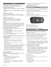
... your Garmin dealer for additional storage or pre-loaded maps. 1 Turn the D-ring counter-clockwise, and pull up to remove the cover. 2 Remove the battery. 3 Slide the card holder À to and lift up. 4 The device has a 3-axis electronic compass (GPSMAP 64s and GPSMAP 64st models .... Compass When navigating, points to your product. Some services may be available for Garmin devices. NOTE: The backlight brightness may not be limited when the battery is available only on the GPSMAP 64s and GPSMAP 64st. 1 Select Sight 'N Go. 2 Point the device at an object in the...
... your Garmin dealer for additional storage or pre-loaded maps. 1 Turn the D-ring counter-clockwise, and pull up to remove the cover. 2 Remove the battery. 3 Slide the card holder À to and lift up. 4 The device has a 3-axis electronic compass (GPSMAP 64s and GPSMAP 64st models .... Compass When navigating, points to your product. Some services may be available for Garmin devices. NOTE: The backlight brightness may not be limited when the battery is available only on the GPSMAP 64s and GPSMAP 64st. 1 Select Sight 'N Go. 2 Point the device at an object in the...


