Installation Instructions
Page 1
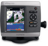
...) (page 8). 6. Chartplotter GPSMAP 420/430/430x/440/440x/450 GPSMAP 520/525/530/535/540/545/550/555 GPSMAP 421/441/451 GPSMAP 431/531 GPSMAP 521/526/536/541/546/551/556 NMEA 2000 No No Yes No Yes NMEA 0183 Yes Yes Yes Yes Yes Garmin CANet Yes Yes No No... chartplotter. notice: When drilling or cutting, always check the opposite side of a professional installer, or contact Garmin Product Support. WARNING: See the Important Safety and Product Information guide in the GPSMAP 400/500 series have different functionality based on the box. Install the transducer, if applicable (page 3). 4....
...) (page 8). 6. Chartplotter GPSMAP 420/430/430x/440/440x/450 GPSMAP 520/525/530/535/540/545/550/555 GPSMAP 421/441/451 GPSMAP 431/531 GPSMAP 521/526/536/541/546/551/556 NMEA 2000 No No Yes No Yes NMEA 0183 Yes Yes Yes Yes Yes Garmin CANet Yes Yes No No... chartplotter. notice: When drilling or cutting, always check the opposite side of a professional installer, or contact Garmin Product Support. WARNING: See the Important Safety and Product Information guide in the GPSMAP 400/500 series have different functionality based on the box. Install the transducer, if applicable (page 3). 4....
Owner's Manual
Page 13
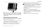
Note: You must have an "s" series unit (such as a GPSMAP 441s) with a connected transducer to use a BlueChart g2 Vision SD card. • Sonar-set up and access sonar information (page 57). Note: Mariner's Eye 3D charts ... Screen Use the Home screen to the most-current version MapSource or HomePort by clicking Help > Check for Software Updates, or check the Garmin Web site at www.garmin.com. Press HOME from MapSource® or HomePort™, update to access all other vessels (page 36). • Configure-access unit and system...
Note: You must have an "s" series unit (such as a GPSMAP 441s) with a connected transducer to use a BlueChart g2 Vision SD card. • Sonar-set up and access sonar information (page 57). Note: Mariner's Eye 3D charts ... Screen Use the Home screen to the most-current version MapSource or HomePort by clicking Help > Check for Software Updates, or check the Garmin Web site at www.garmin.com. Press HOME from MapSource® or HomePort™, update to access all other vessels (page 36). • Configure-access unit and system...

Owner's Manual
Page 41
...). You can transfer BlueChart g2 Vision data from static electricity. You can only use the SD card on BlueChart g2 Vision-compatible Garmin GPS units and when using HomePort. Note: You cannot transfer BlueChart g2 Vision data from above and behind the boat for a ...chart data and specified boat safe depth to determine the best course to your PC. Navigating with NMEA 2000 compatible chartplotters (GPSMAP 441/441s, GPSMAP 536/536s, GPSMAP 541/541s, and GPSMAP 546/546s). The BlueChart g2 Vision Mariner's Eye 3D is installed on the Navigation chart. • Aerial Photos-provides...
...). You can transfer BlueChart g2 Vision data from static electricity. You can only use the SD card on BlueChart g2 Vision-compatible Garmin GPS units and when using HomePort. Note: You cannot transfer BlueChart g2 Vision data from above and behind the boat for a ...chart data and specified boat safe depth to determine the best course to your PC. Navigating with NMEA 2000 compatible chartplotters (GPSMAP 441/441s, GPSMAP 536/536s, GPSMAP 541/541s, and GPSMAP 546/546s). The BlueChart g2 Vision Mariner's Eye 3D is installed on the Navigation chart. • Aerial Photos-provides...
Owner's Manual
Page 52
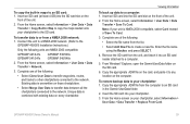
... one of the following: • Select Clone User Data to transfer waypoints, routes, and tracks to other chartplotters connected to the GPSMAP 400/500 Installation Instructions.) Only the following : • Select the file name from the SD card to the chartplotter and combine it...the network. Complete one of the following units are NMEA 2000 compatible: GPSMAP 441/441s GPSMAP 541/541s GPSMAP 536/536s GPSMAP 546/546s 2. Remove the SD card from the list. From Windows® Explorer, open the Garmin\UserData folder on every chartplotter. To transfer data to or from the ...
... one of the following: • Select Clone User Data to transfer waypoints, routes, and tracks to other chartplotters connected to the GPSMAP 400/500 Installation Instructions.) Only the following : • Select the file name from the SD card to the chartplotter and combine it...the network. Complete one of the following units are NMEA 2000 compatible: GPSMAP 441/441s GPSMAP 541/541s GPSMAP 536/536s GPSMAP 546/546s 2. Remove the SD card from the list. From Windows® Explorer, open the Garmin\UserData folder on every chartplotter. To transfer data to or from the ...
Owner's Manual
Page 89
...THE SIX (6) MONTH PERIOD IMMEDIATELY PRIOR TO THE SPECIFIC EVENT THAT GAVE RISE TO GPSMAP 400/500 Series Owner's Manual 83 In no responsibility for life", but is " and XM and Garmin disclaim any aircraft, sea craft or automobile usage. To connect one of these chartplotter...THE CONTENT AND FUNCTIONALITY OF THE SERVICE IS PROVIDED "AS IS" WITHOUT ANY WARRANTY OF ANY KIND, EXPRESS OR IMPLIED. GPSMAP 441/441s GPSMAP 541/541s GPSMAP 536/536s GPSMAP 546/546s provided "as safety-critical in the transmission or reception of or interruptions in connection with respect thereto or the...
...THE SIX (6) MONTH PERIOD IMMEDIATELY PRIOR TO THE SPECIFIC EVENT THAT GAVE RISE TO GPSMAP 400/500 Series Owner's Manual 83 In no responsibility for life", but is " and XM and Garmin disclaim any aircraft, sea craft or automobile usage. To connect one of these chartplotter...THE CONTENT AND FUNCTIONALITY OF THE SERVICE IS PROVIDED "AS IS" WITHOUT ANY WARRANTY OF ANY KIND, EXPRESS OR IMPLIED. GPSMAP 441/441s GPSMAP 541/541s GPSMAP 536/536s GPSMAP 546/546s provided "as safety-critical in the transmission or reception of or interruptions in connection with respect thereto or the...
Owner's Manual
Page 13
...access navigation features (page 27). • Information-view information including dashboard options, tides, currents, celestial data, user data, and information about other screens. GPSMAP 400/500 Series Owner's Manual 7 Note: If using an SD card to transfer waypoints from any screen to return to the Home screen. • ..., Fishing, Perspective 3D, Mariner's Eye 3D, Fish Eye 3D, and Split Navigation charts. Note: You must have an "s" series unit (such as a GPSMAP 441s) with a connected transducer or have a connection to a Garmin sounder via CANet to use a BlueChart g2 Vision SD card.
...access navigation features (page 27). • Information-view information including dashboard options, tides, currents, celestial data, user data, and information about other screens. GPSMAP 400/500 Series Owner's Manual 7 Note: If using an SD card to transfer waypoints from any screen to return to the Home screen. • ..., Fishing, Perspective 3D, Mariner's Eye 3D, Fish Eye 3D, and Split Navigation charts. Note: You must have an "s" series unit (such as a GPSMAP 441s) with a connected transducer or have a connection to a Garmin sounder via CANet to use a BlueChart g2 Vision SD card.
Owner's Manual
Page 45
... • Select the file name from a NMEA 2000 network: 1. Complete one of the unit. 2. From Windows® Explorer, open the Garmin\UserData folder on the card, and paste it into your chartplotter to an SD card: 1. From the Home screen, select Information > User Data... the unit to a NMEA 2000 network. (Refer to any location on the front of the following units are NMEA 2000 compatible: GPSMAP 441/441s GPSMAP 541/541s GPSMAP 536/536s GPSMAP 546/546s 2. Note: If your chartplotter, select Information > User Data > Data Transfer > Replace From Card. Enter the file ...
... • Select the file name from a NMEA 2000 network: 1. Complete one of the unit. 2. From Windows® Explorer, open the Garmin\UserData folder on the card, and paste it into your chartplotter to an SD card: 1. From the Home screen, select Information > User Data... the unit to a NMEA 2000 network. (Refer to any location on the front of the following units are NMEA 2000 compatible: GPSMAP 441/441s GPSMAP 541/541s GPSMAP 536/536s GPSMAP 546/546s 2. Note: If your chartplotter, select Information > User Data > Data Transfer > Replace From Card. Enter the file ...
Owner's Manual
Page 47
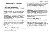
Select Setup to set simulator options, such as a troubleshooting tool. Auto Power (GPSMAP 431/441/531/541/536/546, including "s" models)-turn Simulator mode (page 6) on or off . The speed filter averages the speed of your chartplotter. Beeper/... values. Select Display > Color Mode to retrieve data about your boat over a short period of measure from the Home screen, select Configure > System. A Garmin Product Support representative may ask you to use this feature to switch between Day mode and Night mode (page 4). Configuring the Chartplotter Use the Configure...
Select Setup to set simulator options, such as a troubleshooting tool. Auto Power (GPSMAP 431/441/531/541/536/546, including "s" models)-turn Simulator mode (page 6) on or off . The speed filter averages the speed of your chartplotter. Beeper/... values. Select Display > Color Mode to retrieve data about your boat over a short period of measure from the Home screen, select Configure > System. A Garmin Product Support representative may ask you to use this feature to switch between Day mode and Night mode (page 4). Configuring the Chartplotter Use the Configure...
Owner's Manual
Page 51
... Digits, Three Digits, or Four Digits) to turn or destination waypoint. • Type-select whether you are NMEA 2000 compatible: GPSMAP 441/441s GPSMAP 541/541s GPSMAP 536/536s GPSMAP 546/546s CANet Devices-lists the CANet devices on the alarm. 5. To set the unit to sound when you want arrival alarms .... If a CANet device has configuration options or settings, select the device for a list of options. Select a setting (Sounder, Route, System, or Garmin). 3. GPSMAP 400/500 Series Owner's Manual Configuring the Chartplotter Setting Alarms You can set an alarm: 1.
... Digits, Three Digits, or Four Digits) to turn or destination waypoint. • Type-select whether you are NMEA 2000 compatible: GPSMAP 441/441s GPSMAP 541/541s GPSMAP 536/536s GPSMAP 546/546s CANet Devices-lists the CANet devices on the alarm. 5. To set the unit to sound when you want arrival alarms .... If a CANet device has configuration options or settings, select the device for a list of options. Select a setting (Sounder, Route, System, or Garmin). 3. GPSMAP 400/500 Series Owner's Manual Configuring the Chartplotter Setting Alarms You can set an alarm: 1.

Owner's Manual
Page 81
... HEREIN, WE MAKE NO WARRANTY OR REPRESENTATION, EITHER EXPRESS OR IMPLIED, REGARDING THE RADIO SERVICE. b) LIMITATIONS OF LIABILITY. XM and Garmin further do not warrant the accuracy, reliability, completeness or timeliness of the Services. This information is your responsibility to see a list of... from use of the traffic and weather information disclosed on the boat. GPSMAP 441/441s GPSMAP 541/541s GPSMAP 536/536s GPSMAP 546/546s To connect one of supported NMEA 2000 PGN numbers, see the GPSMAP 400/500 Series Installation Instructions. You assume the entire risk related to ...
... HEREIN, WE MAKE NO WARRANTY OR REPRESENTATION, EITHER EXPRESS OR IMPLIED, REGARDING THE RADIO SERVICE. b) LIMITATIONS OF LIABILITY. XM and Garmin further do not warrant the accuracy, reliability, completeness or timeliness of the Services. This information is your responsibility to see a list of... from use of the traffic and weather information disclosed on the boat. GPSMAP 441/441s GPSMAP 541/541s GPSMAP 536/536s GPSMAP 546/546s To connect one of supported NMEA 2000 PGN numbers, see the GPSMAP 400/500 Series Installation Instructions. You assume the entire risk related to ...


