Garmin GPSMAP 441 Support Question
Garmin GPSMAP 441 Support Question
Find answers below for this question about Garmin GPSMAP 441.Need a Garmin GPSMAP 441 manual? We have 9 online manuals for this item!
Question posted by Wolteringd on July 10th, 2020
Garmin Gpsmap 441s Depth Reading Disappeared
my Garmin GPSMAP 441s has stopped showing depth. All other aspects of navigation seem to working well Was showing depth and now it's not Actually, it may be showing me depths that are roughly 8 times larger than actual for example I'm seeing 89.2 ft when I know the depth is closer to 10 or 12 ft
Current Answers
Answer #1: Posted by INIMITABLE on July 10th, 2020 11:57 AM
INIMITABLE

Member since:
April 3rd, 2020 Points: 2,082,030

Member since:
April 3rd, 2020 Points: 2,082,030
Watch this tutorial video for troubleshooting
I hope this is helpful? PLEASE "ACCEPT" and mark it "HELPFUL" to complement my little effort. Hope to bring you more detailed answers
-INIMITABLE
Related Garmin GPSMAP 441 Manual Pages
Technical Reference for Garmin NMEA 2000 Products - Page 40
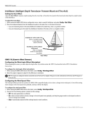
... Enter a (-) negative
number to show depth at the surface.
Select the angle in degrees to adjust for Garmin NMEA 2000 Products While viewing the ... lowest point of the boat (keel) rather than the actual location of the boat, and 270 degrees is not filtered...measuring down to show depth at the bottom of the boat. Tip: The angles are measuring up to display a depth reading from the water...
Owner's Manual - Page 13
... a GPSMAP 441s) with a connected transducer to use sonar features.
• Chart/Sonar-set up the screen to access all other vessels (page 36). • Configure-access unit and system settings (page 48).
Press HOME from MapSource® or HomePort™, update to the Home screen.
• Charts-selects Navigation, Fishing, Perspective 3D, Mariner's Eye...
Owner's Manual - Page 14

...GPSMAP 400/500 Series Owner's Manual
This chart works well for the USA and Bahamas shoreline.
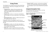
• Navigation Chart-displays all relevant navigation data available on the chart.
• Mariner...navigation aid. Your boat
Exposed wreck
Light
Exposed rock
Tide station
Beacon Marine services Zoom scale
Navigation Chart with enhanced bottom contours and without navigational... depth soundings...
Owner's Manual - Page 24
... off. Data Bars-shows or hides cruising, navigation, fishing, fuel, or sailing numbers (page 9). View-selects a fish eye view (Fore, Aft, Port, or Starboard).
18
Sonar Cone (only available if sonar is present)-displays suspended targets (such as a GPSMAP 441s) with a connected transducer to adjust the view. Safe Depth-adjusts the depth at which red indicates...
Owner's Manual - Page 41

... g2 Vision data from the SD card to your unit. Navigating with NMEA 2000 compatible chartplotters (GPSMAP 441/441s, GPSMAP 536/536s, GPSMAP 541/541s, and GPSMAP 546/546s). GPSMAP 400/500 Series Owner's Manual 35 The BlueChart g2 Vision Mariner's Eye 3D is installed on BlueChart g2 Vision-compatible Garmin GPS units and when using HomePort. You can only use...
Owner's Manual - Page 52
...chartplotter. Connect the unit to a NMEA 2000 network. (Refer to the
GPSMAP 400/500 Installation Instructions.)
Only the following :
• Select Merge ...computer.
46
GPSMAP 400/500 Series Owner's Manual From Windows® Explorer, open the Garmin\UserData folder on the front of the following units are NMEA 2000 compatible:
GPSMAP 441/441s GPSMAP 541/541s
GPSMAP 536/536s GPSMAP 546/546s...
Owner's Manual - Page 63
... > Flasher.
The scale indicates what is organized as fishfinders:
GPSMAP 431s GPSMAP 441s GPSMAP 531s GPSMAP 536s GPSMAP 541s GPSMAP 546s
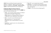
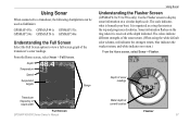
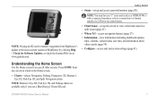
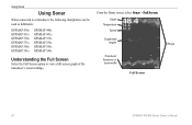
Understanding the Full Screen
Select the Full Screen option to display sonar information on the ring when it is received at the depth indicated. Sonar information flashes on a circular depth scale.
From the Home screen, select Sonar > Full...
Owner's Manual - Page 65
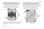
... along the bottom.
Press MENU to set the duration and the scale for the log.
Understanding the Depth Log Screen
The Depth Log screen keeps a graphic log of temperature readings over time. From the Home screen, select Sonar > Temp Log. Temp Log
GPSMAP 400/500 Series Owner's Manual
59 From the Home screen, select Sonar...
Owner's Manual - Page 83
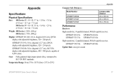
.... (560 g) 500 Series: 1.75 lb. (800 g)
Display: GPSMAP 431/441: 4.0 in . GPSMAP 531/541: 5.0 in . (75 cm)
Performance Receiver: High-sensitivity, 14 parallel channel, WAAS-capable receiver.
GPSMAP 536/536s GPSMAP 546/546s Update Rate: once per second
GPSMAP 400/500 Series Owner's Manual 77 GPSMAP 431/431s GPSMAP 441/441s GPSMAP 531/531s GPSMAP 541/541s High-sensitivity, 12 parallel channel...
Owner's Manual - Page 84
GPS Accuracy: Position: Appendix
Acquisition Times: (Average acquisition times for a stationary receiver with a clear view of the sky) GPSMAP 431/431s GPSMAP 441/441s GPSMAP 531/531s GPSMAP 541/541s
Warm:* Approximately 1 second Cold:** Approximately 38 seconds
GPSMAP 536/536s GPSMAP 546/546s
Warm:* Approximately 15 seconds Cold:** Approximately 38 seconds
*Warm: your unit is at or near the last...
Owner's Manual - Page 89
GPSMAP 441/441s GPSMAP 541/541s
GPSMAP 536/536s GPSMAP 546/546s
provided "as safety-critical in the transmission or reception of or ...DURING THE SIX (6) MONTH PERIOD IMMEDIATELY PRIOR TO THE SPECIFIC EVENT THAT GAVE RISE TO
GPSMAP 400/500 Series Owner's Manual 83 XM and Garmin further do not warrant the accuracy, reliability, completeness or timeliness of supported NMEA 2000 PGN ...
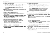
Owner's Manual - Page 3
... > Navigation Chart," you should highlight a series of the main screens to access advanced settings.
• Press and release the Power key to adjust the display settings. Introduction
This manual includes information for the following products:
GPSMAP® 430/430s GPSMAP 431/431s GPSMAP 530/530s GPSMAP 531/531s GPSMAP 540/540s GPSMAP 541/541s
GPSMAP 440/440s GPSMAP 441/441s GPSMAP 535...
Owner's Manual - Page 8
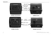
Getting Started
NMEA 2000® XM antenna with
audio adapter
External GPS antenna
Power/Data
GPSMAP 530/535/540/545
External GPS antenna GXM 31 antenna Power/Data
GPSMAP 430x/440x 2
GPSMAP 441/541
GPSMAP 430/431/440 GPSMAP 400/500 Series Owner's Manual
Owner's Manual - Page 13
.... Note: You must have an "s" series unit (such as a GPSMAP 441s) with a connected transducer or have a connection to a Garmin sounder via CANet to the Home screen.
• Charts-selects Navigation, Fishing, Perspective 3D, Mariner's Eye 3D, Fish Eye 3D, and Split Navigation charts. Press HOME from MapSource®, update to access all other vessels (page 34...
Owner's Manual - Page 14
...works well for the USA and Bahamas shoreline.
• Navigation Chart-displays all relevant navigation data available on the chart.
8
• Mariner's Eye 3D-provides a view from above and behind the boat as a navigational aid.
Using the Navigation Chart
Use the Navigation chart to plan your course, to view map information, and as a three-dimensional navigation... cables, depth soundings, ...
Owner's Manual - Page 45
... To restore backup data to the
GPSMAP 400/500 Installation Instructions.)
Only the following units are NMEA 2000 compatible:
GPSMAP 441/441s GPSMAP 541/541s
GPSMAP 536/536s GPSMAP 546/546s
2. Insert the SD ...> User Data > Data Transfer > Save To Card. From Windows® Explorer, open the Garmin\UserData folder on the front of the following :
• Select Clone User Data to transfer ...
Owner's Manual - Page 51
... or Garmin).
3.
Only the following units are NMEA 2000 compatible:
GPSMAP 441/441s GPSMAP 541/541s
GPSMAP 536/536s GPSMAP 546/...Posn.
GPSMAP 400/500 Series Owner's Manual
Configuring the Chartplotter
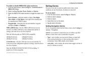
Setting Alarms
You can set a navigation alarm from a turn on your network. Setting Navigation Alarms... on time to arrival or distance to sound an audible alarm when certain ...
Owner's Manual - Page 56
... following chartplotters can be used as fishfinders:
GPSMAP 430s GPSMAP 431s GPSMAP 530s GPSMAP 531s GPSMAP 540s GPSMAP 541s
GPSMAP 440s GPSMAP 441s GPSMAP 535s GPSMAP 536s GPSMAP 545s GPSMAP 546s
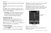
Understanding the Full Screen
Select the Full Screen option to view a full-screen graph of the
transducer's sonar readings.
Depth Temperature
Speed
Suspended targets
Transducer frequency or beam...
Owner's Manual - Page 75
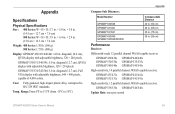
... adjustable brightness, 320 × 240 pixels. GPSMAP 431/431s GPSMAP 441/441s GPSMAP 531/531s GPSMAP 541/541s
High-sensitivity, 12 parallel channel, WAAS-capable receiver. Case: Fully gasketed, high-impact plastic alloy, waterproof to 55ºC)
Appendix
Compass-Safe Distances:
Model Number
GPSMAP 536/546 GPSMAP 431/441 GPSMAP 531/541 GPSMAP 430/440 GPSMAP 530/540/535/545
Compass-Safe...
Owner's Manual - Page 81

GPSMAP 441/441s GPSMAP 541/541s
GPSMAP 536/536s GPSMAP 546/546s
To connect one of the Services. USER SAFETY
If you use of these chartplotter to an existing NMEA 2000 network and to your use XM Services it is your own common sense. XM and Garmin assume no event will XM and Garmin, their data suppliers, service providers...
Similar Questions

Gpsmap 441s Power Doesn't Work
my gpa is about 20 years old. I tried plugging the cable in to the back of the unit and it doesn't p...
my gpa is about 20 years old. I tried plugging the cable in to the back of the unit and it doesn't p...
(Posted by Readsmith 2 years ago)

Depth Gauge Light Blinks, Depth Reading Is Not Accurate
depth gauge light blinks, depth reading is not accurate
depth gauge light blinks, depth reading is not accurate
(Posted by jshunter 5 years ago)

How Do I Go Into Simulation Mode On A Garmin Marine Gps Modle741xs
how do I use simulation mode on a garmin 741xs marine ver
how do I use simulation mode on a garmin 741xs marine ver
(Posted by Curthupp 6 years ago)

Our Garmin Will Not Power Up. Does It Have To Have Sim Card To Power Up?
(Posted by dudleybv 8 years ago)

541s Marine Gps. Depth Not Reading Out.
Depth has been working since installed. Now blank. Is there an on off control for this that may have...
Depth has been working since installed. Now blank. Is there an on off control for this that may have...
(Posted by therad50 11 years ago)