Garmin GPSMAP 441 Support Question
Garmin GPSMAP 441 Support Question
Find answers below for this question about Garmin GPSMAP 441.Need a Garmin GPSMAP 441 manual? We have 9 online manuals for this item!
Question posted by jshunter on June 11th, 2018
Depth Gauge Light Blinks, Depth Reading Is Not Accurate
depth gauge light blinks, depth reading is not accurate
Current Answers
Related Garmin GPSMAP 441 Manual Pages
Installation Instructions - Page 8
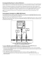
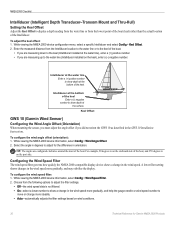
...GPSMAP...NMEA 2000compatible GPSMAP 400/500...GPSMAP 400/500 Series Chartplotter to an Existing NMEA 2000 Network
To connect a NMEA 2000-compatible GPSMAP...full sonar readings, including...GPSMAP 400/500 series chartplotters are available from a CANet-compatible Garmin Sounder or Fishfinder device. A standard NMEA 0183 connection only allows depth...GPSMAP 400/500 series chartplotter is Garmin ...
Installation Instructions - Page 9
... line. When you place your GPSMAP 400/500 series chartplotter.
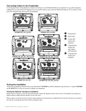
Every possible chartplotter
configuration is out of time without checking for leaks around any screw holes that were added below to configure your boat in the water, check for leaks. You cannot get a depth or distance reading when the transducer is not represented...
Technical Reference for Garmin NMEA 2000 Products - Page 28
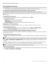
...be powered on the GFS 10 to the fuel gauge or fuel-level sensor of your NMEA 2000 ...more calibration points will provide a more -accurate reading.
Select Config > Level Calibration > Reset Calibration.
24
... of fuel added: 1. Select either GPS Speed or Water Speed to specify which...Fuel-Level Information With a Garmin Chartplotter or Marine Instrument To receive fuel-level information, connect ...
Technical Reference for Garmin NMEA 2000 Products - Page 40
... in the wind speed more gradually, and help the gauge needle or wind speed number to
move or change more gradually, and may stabilize the display. Intelliducer at the water line Enter a (+) positive number to show a change in degrees to display a depth reading from the water line or from the Intelliducer location to...
Owner's Manual - Page 14

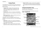
...visually represents the sea floor according to the information on your preloaded maps, including buoys, lights, cables, depth soundings, marinas, and tide stations, in an overhead view.
• Perspective 3D-...Mariner's Eye 3D charts and Fish Eye 3D charts are available only if you use a BlueChart g2 Vision SD card.
• Fishing Chart-provides a view of the chart with g2 Vision
GPSMAP...
Owner's Manual - Page 20
...triangle that is large, medium, or small as your boat icon on the chart.
14
GPSMAP 400/500 Series Owner's Manual World Map-displays a basic world map or satellite imagery (...and sets a dangerous depth. Using Charts
Heading Line-draws an extension line from the g2 Vision chart. Areas with depths shallower than the specified value are shaded in which a navigational light is selected). Symbols...
Owner's Manual - Page 42
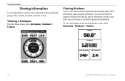
... view the Numbers screen from the Home screen, select Information > Dashboard > Numbers.
36
GPSMAP 400/500 Series Owner's Manual
Viewing a Compass
From the Home screen, select Information > Dashboard > Compass. You can view and customize numerical data including depth, GPS information, and navigation information. Viewing Numbers
You can view up to access information about...
Owner's Manual - Page 54
... NMEA sonar depth data or have a built-in Europe) on or off . GPSMAP 400/500 Series Owner's Manual GPS-view GPS satellites.
• Skyview-view the GPS satellite constellation ...ºC), Nautical (kt, ft, ºF), or Custom.
WAAS/EGNOS can provide more-accurate
48
GPS position information.
Select Display > Backlight to view additional information.
Select Custom to configure unit...
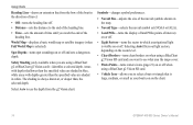
Owner's Manual - Page 60
...Alarms > Weather. 2. Turn the following alarms on or off: marine, tornado, severe
storm, flood, or flash flood. If you... Enter a positive number to offset for the depth of the keel, measure the distance from the ...
You can enter a negative number to measure depth from the bottom of the keel instead of ... My Boat. Keel Offset-compensates for the surface reading for a keel. Fish-set an alarm to ...
Owner's Manual - Page 61
...speed-sensing device.
GPSMAP 400/500 Series Owner's Manual
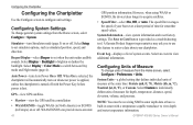
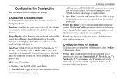
Configuring the Chartplotter
The temperature offset compensates for the temperature reading from the water ... as being warmer than it actually is connected to be accurate.
3. Enter this menu does not appear. Calibrate Water... Bottom of the Keel
A (-) negative number shows depth at the bottom of your transducer. Measure the water...
Owner's Manual - Page 63
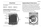
... readings
Transducer frequency or beam width
Full Screen GPSMAP 400/500 Series Owner's Manual
Water depth at the depth indicated. Depth
Temperature
Speed
Suspended targets
Range
Using Sonar
Understanding the Flasher Screen
(GPSMAP 431s/531s/536s only) Use the Flasher screen to display sonar information on the ring when it is organized as fishfinders:
GPSMAP 431s GPSMAP 441s GPSMAP...
Owner's Manual - Page 65
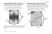
...for the log. Temp Log
GPSMAP 400/500 Series Owner's Manual
59 The present depth is received. Depth
Time elapsed
Depth range
Using Sonar
Understanding the ...depth
Time elapsed
Temperature range
Depth Log
The depth appears along the right side, and the time elapsed appears along the bottom. Understanding the Depth Log Screen
The Depth Log screen keeps a graphic log of temperature readings...
Owner's Manual - Page 91

...54 GPS accuracy...31 depth line 60 depth log 59 depth ...gauges
customizing limits 38 selecting the number of engines 39 status alarms 39 viewing 37 Enter Coordinates 30
F
factory settings, restoring 6 fish eye 3D 18
settings 18 fishing chart 19
AIS 27 MARPA 27 fishing information 73
GPSMAP...mariner's eye 3D 16 navigation 8 settings 12 cleaning the unit 82
Clear User Data 44 close hauled wind gauge...
Owner's Manual - Page 94
...80
offset 55 wave direction 75 wave period 75 Waypoint IDs 51 waypoints 16
creating 30 deleting 30, 31 depth 61 edit existing 16, 30 mark current location 30 moving 30 viewing 44 weather 68
88
Weather Radar 16..., 17 Where To 28 Whiteline 61 wind barbs 74 wind gauges
viewing 41 World Map 14 wind gauges
customizing 41
X
XM Audio 76 XM weather 68
Z
zoom 61 2x 61 4x 61 ...
Owner's Manual - Page 10

...light, select Auto Backlight (automatic backlight is detected, a message will ask if you want to calibrate it now.
Select Yes or No.
Select Color Mode. 3. Press left or right on the GPSMAP... receiving NMEA sonar depth data. Minimum Overhead Clearance-select the minimum overhead clearance for your boat. Getting Started
Minimum Safe Depth-select the minimum safe depth for your boat....
Owner's Manual - Page 14
...3D, and Mariner's Eye 3D views are available when using optional BlueChart g2 Vision preprogrammed SD cards.
• Fishing Chart-provides a view of the chart with g2 Vision GPSMAP 400/500... g2 Vision Mariner's Eye 3D is more detailed than the preloaded data. Using the Navigation Chart
Use the Navigation chart to plan your preloaded maps, including buoys, lights, cables, depth soundings, marinas...
Owner's Manual - Page 20

...off . • Light Sectors-turns the sector in white. Areas with depths shallower than the specified value are shaded in blue, while areas with depths greater than , the selected depth. Symbols-changes symbol ...Selecting Auto filters out light sectors, depending on the zoom level. • Chart Borders-turns chart borders on when using a BlueChart g2 Vision SD card. GPSMAP 400/500 Series Owner...
Owner's Manual - Page 47
...Power (GPSMAP 431/441/531/541/536/546, including "s" models)-turn on or off .
Configuring Units of measure for smoother speed values. GPS-view GPS satellites.
• Skyview-view the GPS satellite...-view system information and reset factory settings.
WAAS/EGNOS can provide more-accurate GPS position information. A Garmin Product Support representative may ask you to use this...
Owner's Manual - Page 53
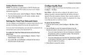
... alarms on the bottom of from the Home screen, select Configure > My Boat. GPSMAP 400/500 Series Owner's Manual
47 Setting the Total Fuel Onboard Alarm
You can configure... 1. Keel Offset-offset the surface reading for the depth of a keel, making it possible to compensate for your chartplotter to the water line (transducer installed on or off: marine, tornado, severe
storm, flood, ...
Owner's Manual - Page 83
...charts
detail 14 fish eye 3D 18 fishing 19 mariner's eye 3D 16 navigation 8 settings 12 cleaning ...34 compass rose 12 contact information, Garmin iv
GPSMAP 400/500 Series Owner's Manual
course up ... of Conformity iv delete a waypoint 30 depth line 52 depth waypoint 53 Detail, chart 14 Details, AIS...gauges 35 full screen, sonar 50 fuse 70
G
gain 54 Garmin Data Transfer 44 gauges, fuel 35 go to 27 GPS...
Similar Questions

Garmin Gpsmap 441s Depth Reading Disappeared
my Garmin GPSMAP 441s has stopped showing depth. All other aspects of navigation seem to working wel...
my Garmin GPSMAP 441s has stopped showing depth. All other aspects of navigation seem to working wel...
(Posted by Wolteringd 3 years ago)

How Do I Go Into Simulation Mode On A Garmin Marine Gps Modle741xs
how do I use simulation mode on a garmin 741xs marine ver
how do I use simulation mode on a garmin 741xs marine ver
(Posted by Curthupp 6 years ago)

Our Garmin Will Not Power Up. Does It Have To Have Sim Card To Power Up?
(Posted by dudleybv 8 years ago)

541s Marine Gps. Depth Not Reading Out.
Depth has been working since installed. Now blank. Is there an on off control for this that may have...
Depth has been working since installed. Now blank. Is there an on off control for this that may have...
(Posted by therad50 11 years ago)