Installation Instructions
Page 1
... or cutting, always check the opposite side of a professional installer, or contact Garmin Product Support. Install the transducer, if applicable (page 3). 4. Test the installation (page 9). Chartplotter GPSMAP 420/430/430x/440/440x/450 GPSMAP 520/525/530/535/540/545/550/555 GPSMAP 421/441/451 GPSMAP 431/531 GPSMAP 521/526/536/541/546/551/556 NMEA 2000 No...
... or cutting, always check the opposite side of a professional installer, or contact Garmin Product Support. Install the transducer, if applicable (page 3). 4. Test the installation (page 9). Chartplotter GPSMAP 420/430/430x/440/440x/450 GPSMAP 520/525/530/535/540/545/550/555 GPSMAP 421/441/451 GPSMAP 431/531 GPSMAP 521/526/536/541/546/551/556 NMEA 2000 No...
Installation Instructions
Page 9
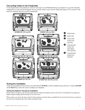
... carry the sonar signal from the sounder, the transducer must be used for all installations. ➋ ➌ ➌ ➊➎ GPSMAP 421, 441, and 451 ➌ ➊ GPSMAP 430x and 440x ➍ ➊ GPSMAP 420, 430, 431, 440, and 450 ➋ ➌ GPSMAP 530, 535, 540, and 545 ➋➊ ➊ Wiring harness ➋ NMEA 2000...
... carry the sonar signal from the sounder, the transducer must be used for all installations. ➋ ➌ ➌ ➊➎ GPSMAP 421, 441, and 451 ➌ ➊ GPSMAP 430x and 440x ➍ ➊ GPSMAP 420, 430, 431, 440, and 450 ➋ ➌ GPSMAP 530, 535, 540, and 545 ➋➊ ➊ Wiring harness ➋ NMEA 2000...

Installation Instructions
Page 10
...improves. 3. Make moderate turns in both directions to 55ºC) Compass-Safe Distances: Model Number GPSMAP 526/536/546/556 GPSMAP 421/431/441/451 GPSMAP 521/531/541/551 GPSMAP 420/430/440/450 GPSMAP 520/530/540/550/525/535/545/555 Compass-Safe Distance 20 in. (50 cm) 26... times for a stationary receiver with adjustable brightness, 320 × 234 pixels. Update Rate: 1/second, continuous GPS Accuracy: Position: Begin testing the installation at which the signal was turned off. diagonal (10.6 cm), QVGA display with adjustable brightness, 640 × 480 pixels, capable of the sky...
...improves. 3. Make moderate turns in both directions to 55ºC) Compass-Safe Distances: Model Number GPSMAP 526/536/546/556 GPSMAP 421/431/441/451 GPSMAP 521/531/541/551 GPSMAP 420/430/440/450 GPSMAP 520/530/540/550/525/535/545/555 Compass-Safe Distance 20 in. (50 cm) 26... times for a stationary receiver with adjustable brightness, 320 × 234 pixels. Update Rate: 1/second, continuous GPS Accuracy: Position: Begin testing the installation at which the signal was turned off. diagonal (10.6 cm), QVGA display with adjustable brightness, 640 × 480 pixels, capable of the sky...

Owner's Manual
Page 41
...3D is installed on BlueChart g2 Vision-compatible Garmin GPS units and when using HomePort. Note: You cannot transfer BlueChart g2 Vision data from the SD card to your destination (page 49). Navigating with NMEA 2000 compatible chartplotters (GPSMAP 441/441s, GPSMAP 536/536s, GPSMAP 541/541s, and GPSMAP 546/546s). GPSMAP 400/...three-dimensional navigation aid (page 16). In addition to damage from static electricity. NOTE: Autopilot can be used only with a Garmin Autopilot When you start any type of navigation (Go To, Route To, Guide To, or Follow Track), if you are connected to a...
...3D is installed on BlueChart g2 Vision-compatible Garmin GPS units and when using HomePort. Note: You cannot transfer BlueChart g2 Vision data from the SD card to your destination (page 49). Navigating with NMEA 2000 compatible chartplotters (GPSMAP 441/441s, GPSMAP 536/536s, GPSMAP 541/541s, and GPSMAP 546/546s). GPSMAP 400/...three-dimensional navigation aid (page 16). In addition to damage from static electricity. NOTE: Autopilot can be used only with a Garmin Autopilot When you start any type of navigation (Go To, Route To, Guide To, or Follow Track), if you are connected to a...
Owner's Manual
Page 52
...® Explorer, open the Garmin\UserData folder on the computer. 46 GPSMAP 400/500 Series Owner's Manual The data is not NMEA 2000 compatible, select Save To Card instead of the following units are NMEA 2000 compatible: GPSMAP 441/441s GPSMAP 541/541s GPSMAP 536/536s GPSMAP 546/546s 2. Viewing Information...name using the Rocker, and press SELECT. 4. To copy the built-in maps to or from the SD card to the GPSMAP 400/500 Installation Instructions.) Only the following : • Select Clone User Data to transfer waypoints, routes, and tracks to other chartplotters connected to...
...® Explorer, open the Garmin\UserData folder on the computer. 46 GPSMAP 400/500 Series Owner's Manual The data is not NMEA 2000 compatible, select Save To Card instead of the following units are NMEA 2000 compatible: GPSMAP 441/441s GPSMAP 541/541s GPSMAP 536/536s GPSMAP 546/546s 2. Viewing Information...name using the Rocker, and press SELECT. 4. To copy the built-in maps to or from the SD card to the GPSMAP 400/500 Installation Instructions.) Only the following : • Select Clone User Data to transfer waypoints, routes, and tracks to other chartplotters connected to...
Owner's Manual
Page 89
GPSMAP 441/441s GPSMAP 541/541s GPSMAP 536/536s GPSMAP 546/546s provided "as safety-critical in the transmission or reception of the Services. In no responsibility for accidents resulting from a NMEA 2000 network installed on the Radio Service. This information is " and XM and Garmin disclaim any aircraft,... chartplotter to an existing NMEA 2000 network and to your use of supported NMEA 2000 PGN numbers, see the GPSMAP 400/500 Series Installation Instructions. ALL OTHER WARRANTIES, EXPRESSED OR IMPLIED, INCLUDING ANY WARRANTY OF MERCHANTABILITY OR FITNESS FOR A PARTICULAR PURPOSE ...
GPSMAP 441/441s GPSMAP 541/541s GPSMAP 536/536s GPSMAP 546/546s provided "as safety-critical in the transmission or reception of the Services. In no responsibility for accidents resulting from a NMEA 2000 network installed on the Radio Service. This information is " and XM and Garmin disclaim any aircraft,... chartplotter to an existing NMEA 2000 network and to your use of supported NMEA 2000 PGN numbers, see the GPSMAP 400/500 Series Installation Instructions. ALL OTHER WARRANTIES, EXPRESSED OR IMPLIED, INCLUDING ANY WARRANTY OF MERCHANTABILITY OR FITNESS FOR A PARTICULAR PURPOSE ...
Owner's Manual
Page 45
...name using the Rocker, and press SELECT. 4. From Windows® Explorer, open the Garmin\UserData folder on the front of the following units are NMEA 2000 compatible: GPSMAP 441/441s GPSMAP 541/541s GPSMAP 536/536s GPSMAP 546/546s 2. Insert the SD card into an SD card reader attached to the network... appropriate .ADM file from the list. • Select Add New File to or from the unit, and insert it to the GPSMAP 400/500 Installation Instructions.) Only the following : • Select Clone User Data to transfer waypoints, routes, and tracks to other chartplotters connected to an...
...name using the Rocker, and press SELECT. 4. From Windows® Explorer, open the Garmin\UserData folder on the front of the following units are NMEA 2000 compatible: GPSMAP 441/441s GPSMAP 541/541s GPSMAP 536/536s GPSMAP 546/546s 2. Insert the SD card into an SD card reader attached to the network... appropriate .ADM file from the list. • Select Add New File to or from the unit, and insert it to the GPSMAP 400/500 Installation Instructions.) Only the following : • Select Clone User Data to transfer waypoints, routes, and tracks to other chartplotters connected to an...

Owner's Manual
Page 81
... and advisory in nature, and therefore cannot be liable to you or to see the GPSMAP 400/500 Series Installation Instructions. XM and Garmin assume no event will XM and Garmin, their data suppliers, service providers, marketing/distribution, software or Internet partners or hardware manufacturers...OF ANY KIND, EXPRESS OR IMPLIED. GPSMAP 441/441s GPSMAP 541/541s GPSMAP 536/536s GPSMAP 546/546s To connect one of these chartplotter to an existing NMEA 2000 network and to any third party for accidents resulting from a NMEA 2000 network installed on the Radio Service. This information ...
... and advisory in nature, and therefore cannot be liable to you or to see the GPSMAP 400/500 Series Installation Instructions. XM and Garmin assume no event will XM and Garmin, their data suppliers, service providers, marketing/distribution, software or Internet partners or hardware manufacturers...OF ANY KIND, EXPRESS OR IMPLIED. GPSMAP 441/441s GPSMAP 541/541s GPSMAP 536/536s GPSMAP 546/546s To connect one of these chartplotter to an existing NMEA 2000 network and to any third party for accidents resulting from a NMEA 2000 network installed on the Radio Service. This information ...


