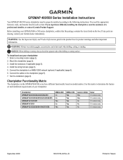
Installation Instructions
Page 1
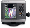
.../430/430x/440/440x/450 GPSMAP 520/525/530/535/540/545/550/555 GPSMAP 421/441/451 GPSMAP 431/531 GPSMAP 521/526/536/541/546/551/556 NMEA 2000 No No Yes No Yes NMEA 0183 Yes Yes Yes Yes Yes Garmin CANet Yes Yes No No No Sonar "s" version only "s" version only "s" version only... "s" version only "s" version only September 2009 190-01074-02 Rev. GPSMAP 400...
.../430/430x/440/440x/450 GPSMAP 520/525/530/535/540/545/550/555 GPSMAP 421/441/451 GPSMAP 431/531 GPSMAP 521/526/536/541/546/551/556 NMEA 2000 No No Yes No Yes NMEA 0183 Yes Yes Yes Yes Yes Garmin CANet Yes Yes No No No Sonar "s" version only "s" version only "s" version only... "s" version only "s" version only September 2009 190-01074-02 Rev. GPSMAP 400...
Installation Instructions
Page 9
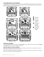
... Because water is listed for leaks. Every connector on . Do not leave your GPSMAP 400/500 series chartplotter. Using the ROCKER and the SELECT keys, follow the screens to carry the sonar signal from the sounder, the transducer must be used for all installations. ➋...; ➌ ➌ ➊➎ GPSMAP 421, 441, and 451 ➌ ➊ GPSMAP 430x and 440x ➍ ➊ GPSMAP 420, 430, 431, 440, and 450 ➋ ➌ GPSMAP 530, 535, 540,...
... Because water is listed for leaks. Every connector on . Do not leave your GPSMAP 400/500 series chartplotter. Using the ROCKER and the SELECT keys, follow the screens to carry the sonar signal from the sounder, the transducer must be used for all installations. ➋...; ➌ ➌ ➊➎ GPSMAP 421, 441, and 451 ➌ ➊ GPSMAP 430x and 440x ➍ ➊ GPSMAP 420, 430, 431, 440, and 450 ➋ ➌ GPSMAP 530, 535, 540,...

Installation Instructions
Page 10
..., 320 × 234 pixels. If the sonar appears to see if the signal improves. 3. Make moderate turns in . (95 cm) Performance Receiver: GPSMAP 420/430/440/450 (s) GPSMAP 520/530/540/550/525/535/545/555 (s): Differential-ready 12 parallel channel WAAS-capable receiver GPSMAP 421/431/441/451 (s) GPSMAP 521/531/541/551 (s): High-sensitivity...
..., 320 × 234 pixels. If the sonar appears to see if the signal improves. 3. Make moderate turns in . (95 cm) Performance Receiver: GPSMAP 420/430/440/450 (s) GPSMAP 520/530/540/550/525/535/545/555 (s): Differential-ready 12 parallel channel WAAS-capable receiver GPSMAP 421/431/441/451 (s) GPSMAP 521/531/541/551 (s): High-sensitivity...
Owner's Manual
Page 3
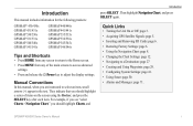
...Then highlight Navigation Chart, and press SELECT again. Introduction This manual includes information for the following products: GPSMAP® 431/431s GPSMAP 531/531s GPSMAP 541/541s GPSMAP 441/441s GPSMAP 536/536s GPSMAP 546/546s Tips and Shortcuts • Press HOME from any screen to return to the Home screen....key to a Destination: page 28. • Creating and Using Waypoints: page 30. • Configuring System Settings: page 48. • Using Sonar: page 57. • Alarms and Messages: page 79. For example, if you see "select Charts > Navigation Chart," you are instructed to ...
...Then highlight Navigation Chart, and press SELECT again. Introduction This manual includes information for the following products: GPSMAP® 431/431s GPSMAP 531/531s GPSMAP 541/541s GPSMAP 441/441s GPSMAP 536/536s GPSMAP 546/546s Tips and Shortcuts • Press HOME from any screen to return to the Home screen....key to a Destination: page 28. • Creating and Using Waypoints: page 30. • Configuring System Settings: page 48. • Using Sonar: page 57. • Alarms and Messages: page 79. For example, if you see "select Charts > Navigation Chart," you are instructed to ...
Owner's Manual
Page 13
Note: If you use sonar features. • Chart/Sonar-set up the screen to the most-current version MapSource or HomePort by clicking Help > Check for Software Updates, or check the Garmin Web site at www.garmin.com. Note: Mariner's Eye 3D charts and Fish Eye 3D charts are ...access unit and system settings (page 48). Note: You must have an "s" series unit (such as a GPSMAP 441s) with a connected transducer to use a BlueChart g2 Vision SD card. • Sonar-set up and access sonar information (page 57). Press HOME from MapSource® or HomePort™, update to view a chart and...
Note: If you use sonar features. • Chart/Sonar-set up the screen to the most-current version MapSource or HomePort by clicking Help > Check for Software Updates, or check the Garmin Web site at www.garmin.com. Note: Mariner's Eye 3D charts and Fish Eye 3D charts are ...access unit and system settings (page 48). Note: You must have an "s" series unit (such as a GPSMAP 441s) with a connected transducer to use a BlueChart g2 Vision SD card. • Sonar-set up and access sonar information (page 57). Press HOME from MapSource® or HomePort™, update to view a chart and...
Owner's Manual
Page 24
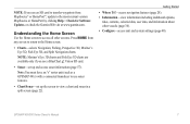
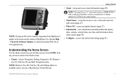
...the largest targets and green indicates the smallest targets. View-selects a fish eye view (Fore, Aft, Port, or Starboard). 18 Sonar Cone (only available if sonar is present)-turns a cone that shows the area covered by red, green, and yellow spheres. Fish Eye 3D Settings To access ... of NEXRAD weather on or off . (The Weather feature is only available if the chartplotter is present)-displays suspended targets (such as a GPSMAP 441s) with a connected transducer to adjust the view. Using Fish Eye 3D Using the depth contour lines of the BlueChart g2 Vision cartography, Fish...
...the largest targets and green indicates the smallest targets. View-selects a fish eye view (Fore, Aft, Port, or Starboard). 18 Sonar Cone (only available if sonar is present)-turns a cone that shows the area covered by red, green, and yellow spheres. Fish Eye 3D Settings To access ... of NEXRAD weather on or off . (The Weather feature is only available if the chartplotter is present)-displays suspended targets (such as a GPSMAP 441s) with a connected transducer to adjust the view. Using Fish Eye 3D Using the depth contour lines of the BlueChart g2 Vision cartography, Fish...
Owner's Manual
Page 63
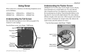
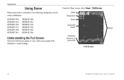
...: GPSMAP 431s GPSMAP 441s GPSMAP 531s GPSMAP 536s GPSMAP 541s GPSMAP 546s Understanding the Full Screen Select the Full Screen option to display sonar information on the ring when it is beneath your boat. The scale indicates what is received at the top and progresses clockwise. Using Sonar When...screen graph of the transducer's sonar readings. The colors indicate different strengths of sonar readings Transducer frequency or beam width Full Screen GPSMAP 400/500 Series Owner's Manual Water depth at current location Flasher 57 Depth of the sonar return. (When using the white...
...: GPSMAP 431s GPSMAP 441s GPSMAP 531s GPSMAP 536s GPSMAP 541s GPSMAP 546s Understanding the Full Screen Select the Full Screen option to display sonar information on the ring when it is beneath your boat. The scale indicates what is received at the top and progresses clockwise. Using Sonar When...screen graph of the transducer's sonar readings. The colors indicate different strengths of sonar readings Transducer frequency or beam width Full Screen GPSMAP 400/500 Series Owner's Manual Water depth at current location Flasher 57 Depth of the sonar return. (When using the white...
Owner's Manual
Page 84
GPS Accuracy: Position: Appendix Acquisition Times: (Average acquisition times for a stationary receiver with a clear view of the sky) GPSMAP 431/431s GPSMAP 441/441s GPSMAP 531/531s GPSMAP 541/541s Warm:* Approximately 1 second Cold:** Approximately 38 seconds GPSMAP 536/536s GPSMAP 546/546s Warm:* Approximately 15 seconds Cold:** Approximately 38 seconds *Warm: your unit is at or near the last location where you recently acquired satellites. **Cold: your unit has moved by more than about 500 mi. (800 km) since it was turned off, or it has been turned off for more than 2 weeks.
GPS Accuracy: Position: Appendix Acquisition Times: (Average acquisition times for a stationary receiver with a clear view of the sky) GPSMAP 431/431s GPSMAP 441/441s GPSMAP 531/531s GPSMAP 541/541s Warm:* Approximately 1 second Cold:** Approximately 38 seconds GPSMAP 536/536s GPSMAP 546/546s Warm:* Approximately 15 seconds Cold:** Approximately 38 seconds *Warm: your unit is at or near the last location where you recently acquired satellites. **Cold: your unit has moved by more than about 500 mi. (800 km) since it was turned off, or it has been turned off for more than 2 weeks.
Owner's Manual
Page 3
.... Introduction This manual includes information for the following products: GPSMAP® 430/430s GPSMAP 431/431s GPSMAP 530/530s GPSMAP 531/531s GPSMAP 540/540s GPSMAP 541/541s GPSMAP 440/440s GPSMAP 441/441s GPSMAP 535/535s GPSMAP 536/536s GPSMAP 545/545s GPSMAP 546/546s Tips and Shortcuts • Press HOME from ...to a Destination: page 27 • Creating and Using Waypoints: page 29. • Configuring System Settings: page 41. • Using Sonar: page 50. • Alarms and Messages: page 71. Then highlight Navigation Chart, and press SELECT again. They indicate that you are ...
.... Introduction This manual includes information for the following products: GPSMAP® 430/430s GPSMAP 431/431s GPSMAP 530/530s GPSMAP 531/531s GPSMAP 540/540s GPSMAP 541/541s GPSMAP 440/440s GPSMAP 441/441s GPSMAP 535/535s GPSMAP 536/536s GPSMAP 545/545s GPSMAP 546/546s Tips and Shortcuts • Press HOME from ...to a Destination: page 27 • Creating and Using Waypoints: page 29. • Configuring System Settings: page 41. • Using Sonar: page 50. • Alarms and Messages: page 71. Then highlight Navigation Chart, and press SELECT again. They indicate that you are ...
Owner's Manual
Page 13
...page 50). Note: Mariner's Eye 3D, Fish Eye 3D, and Fishing charts are available only if you use sonar features. • Chart/Sonar-set up the screen to view a chart and sonar in a split screen (page 21). • Where To?-access navigation features (page 27). • Information-...(page 34). • Configure-access unit and system settings (page 41). GPSMAP 400/500 Series Owner's Manual 7 Note: You must have an "s" series unit (such as a GPSMAP 441s) with a connected transducer or have a connection to a Garmin sounder via CANet to use a BlueChart g2 Vision SD card. Note: If...
...page 50). Note: Mariner's Eye 3D, Fish Eye 3D, and Fishing charts are available only if you use sonar features. • Chart/Sonar-set up the screen to view a chart and sonar in a split screen (page 21). • Where To?-access navigation features (page 27). • Information-...(page 34). • Configure-access unit and system settings (page 41). GPSMAP 400/500 Series Owner's Manual 7 Note: You must have an "s" series unit (such as a GPSMAP 441s) with a connected transducer or have a connection to a Garmin sounder via CANet to use a BlueChart g2 Vision SD card. Note: If...
Owner's Manual
Page 56
Depth Temperature Speed Suspended targets Transducer frequency or beam width Full Screen Range 50 GPSMAP 400/500 Series Owner's Manual Using Sonar Using Sonar When connected to a transducer, the following chartplotters can be used as fishfinders: GPSMAP 430s GPSMAP 431s GPSMAP 530s GPSMAP 531s GPSMAP 540s GPSMAP 541s GPSMAP 440s GPSMAP 441s GPSMAP 535s GPSMAP 536s GPSMAP 545s GPSMAP 546s Understanding the Full Screen Select the Full Screen option to view a full-screen graph of the transducer's sonar readings. From the Home screen, select Sonar > Full Screen.
Depth Temperature Speed Suspended targets Transducer frequency or beam width Full Screen Range 50 GPSMAP 400/500 Series Owner's Manual Using Sonar Using Sonar When connected to a transducer, the following chartplotters can be used as fishfinders: GPSMAP 430s GPSMAP 431s GPSMAP 530s GPSMAP 531s GPSMAP 540s GPSMAP 541s GPSMAP 440s GPSMAP 441s GPSMAP 535s GPSMAP 536s GPSMAP 545s GPSMAP 546s Understanding the Full Screen Select the Full Screen option to view a full-screen graph of the transducer's sonar readings. From the Home screen, select Sonar > Full Screen.
Owner's Manual
Page 76
... receiver with a clear view of the sky.) GPSMAP 430/430s GPSMAP 440/440s GPSMAP 530/530s GPSMAP 535/535s GPSMAP 530/540s GPSMAP 535/545s Warm:* Approximately 15 seconds Cold:** Approximately 45 seconds GPSMAP 431/431s GPSMAP 441/441s GPSMAP 531/531s GPSMAP 541/541s Warm:* Approximately 1 second Cold:** Approximately 38 seconds GPSMAP 536/536s GPSMAP 546/546s Warm:* Approximately 15 seconds Cold:** Approximately...
... receiver with a clear view of the sky.) GPSMAP 430/430s GPSMAP 440/440s GPSMAP 530/530s GPSMAP 535/535s GPSMAP 530/540s GPSMAP 535/545s Warm:* Approximately 15 seconds Cold:** Approximately 45 seconds GPSMAP 431/431s GPSMAP 441/441s GPSMAP 531/531s GPSMAP 541/541s Warm:* Approximately 1 second Cold:** Approximately 38 seconds GPSMAP 536/536s GPSMAP 546/546s Warm:* Approximately 15 seconds Cold:** Approximately...


