
Owner's Manual
Page 3
...manual for reference. The Main Pages section provides detailed explanations about installing your chartplotter, contact Garmin Product Support or a professional installer. If any question about each page in the GPSMAP 292/298 and step-by -step directions for more information. This manual is CANet compatible.... to create an unsurpassed portable GPS receiver. About This Manual To get the most out of this manual and learn the operating procedures for choosing the Garmin® GPSMAP® 292/298. An Index is provided at the end of Garmin GPS and full-featured mapping to ...
...manual for reference. The Main Pages section provides detailed explanations about installing your chartplotter, contact Garmin Product Support or a professional installer. If any question about each page in the GPSMAP 292/298 and step-by -step directions for more information. This manual is CANet compatible.... to create an unsurpassed portable GPS receiver. About This Manual To get the most out of this manual and learn the operating procedures for choosing the Garmin® GPSMAP® 292/298. An Index is provided at the end of Garmin GPS and full-featured mapping to ...
Owner's Manual
Page 4
... TABLE OF CONTENTS Table of Contents Introduction i About This Manual i Warning iv Important Information iv Basic Operation 1 Turning on the GPSMAP 292/298 1 Using Simulator Mode 3 Adjusting the Backlight 4 Using the GPSMAP 292/298 Keypad 5 Entering Data and Selecting Options 6 Using the Map Pointer 7 Creating and Using Waypoints 8 Man OverBoard (MOB 10...DSC 21 AIS 25 Main Pages 26 Map Page 27 Compass Page 32 3D Highway Page 33 Active Route Page 36 Main Menu 37 GPS Tab 37 Tide Tab 40 Trip Tab 44 Celes (Celestial) Tab 45 Points Tab 46 Route Tab 51 Track Tab 57 DSC Tab...
... TABLE OF CONTENTS Table of Contents Introduction i About This Manual i Warning iv Important Information iv Basic Operation 1 Turning on the GPSMAP 292/298 1 Using Simulator Mode 3 Adjusting the Backlight 4 Using the GPSMAP 292/298 Keypad 5 Entering Data and Selecting Options 6 Using the Map Pointer 7 Creating and Using Waypoints 8 Man OverBoard (MOB 10...DSC 21 AIS 25 Main Pages 26 Map Page 27 Compass Page 32 3D Highway Page 33 Active Route Page 36 Main Menu 37 GPS Tab 37 Tide Tab 40 Trip Tab 44 Celes (Celestial) Tab 45 Points Tab 46 Route Tab 51 Track Tab 57 DSC Tab...
Owner's Manual
Page 5
... Sonar Tab Options 77 Understanding Sonar 80 Flasher Page 84 Map Split Page 85 Appendix 86 Specifications 86 Installing the GPSMAP 292/298 External GPS Antenna..... 87 Mounting the GPSMAP 292/298 88 Installing the Transducer 90 Connecting the Power/Data Cable 92 Interfacing 93 Caring for the Screen 93 Installing and Removing... 105 Software License Agreement 106 Product Registration 106 Limited Warranty 107 FCC Compliance 108 Industry Canada Compliance 108 Declaration of Conformity (DoC 108 Index 109 GPSMAP 292/298 Owner's Manual iii
... Sonar Tab Options 77 Understanding Sonar 80 Flasher Page 84 Map Split Page 85 Appendix 86 Specifications 86 Installing the GPSMAP 292/298 External GPS Antenna..... 87 Mounting the GPSMAP 292/298 88 Installing the Transducer 90 Connecting the Power/Data Cable 92 Interfacing 93 Caring for the Screen 93 Installing and Removing... 105 Software License Agreement 106 Product Registration 106 Limited Warranty 107 FCC Compliance 108 Industry Canada Compliance 108 Declaration of Conformity (DoC 108 Index 109 GPSMAP 292/298 Owner's Manual iii
Owner's Manual
Page 7
... are only asked this the first time you turn on the GPSMAP 292/298, the receiver must be given an opportunity to collect satellite data and establish its present location. The GPS Information Page appears as the receiver begins acquiring satellites. Press and hold the POWER key until the power tone... sounds, and then release the POWER key. The page goes away after you turn on the GPSMAP 292/298 unit, make sure the unit...
... are only asked this the first time you turn on the GPSMAP 292/298, the receiver must be given an opportunity to collect satellite data and establish its present location. The GPS Information Page appears as the receiver begins acquiring satellites. Press and hold the POWER key until the power tone... sounds, and then release the POWER key. The page goes away after you turn on the GPSMAP 292/298 unit, make sure the unit...
Owner's Manual
Page 8
... prompting you to initialize the unit. Use the ROCKER to move the map pointer to your approximate location on the ROCKER until the GPS tab is not necessary to select your approximate location with the appropriate satellite number under each satellite in any way, rather it is ...not calibrate the unit in view appears on the bottom of the screen shows "Ready for Navigation", and the GPSMAP 292/298 is ready for the satellites indicated. • Hollow signal strength bars-the receiver has found the indicated satellite(s) and is collecting data. • Solid signal strength bars-the...
... prompting you to initialize the unit. Use the ROCKER to move the map pointer to your approximate location on the ROCKER until the GPS tab is not necessary to select your approximate location with the appropriate satellite number under each satellite in any way, rather it is ...not calibrate the unit in view appears on the bottom of the screen shows "Ready for Navigation", and the GPSMAP 292/298 is ready for the satellites indicated. • Hollow signal strength bars-the receiver has found the indicated satellite(s) and is collecting data. • Solid signal strength bars-the...
Owner's Manual
Page 9
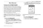
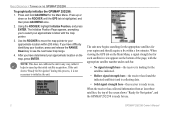
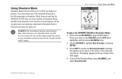
Using Simulator Mode Simulator Mode turns the GPS receiver off for actual navigation. Any satellite signal strength bars shown are only simulations and do not represent the strength of the functions discussed in the following pages in Simulator Mode. GPSMAP 292/298 Owner's Manual 3 WARNING: Do not ...3. BASIC OPERATION > USING SIMULATOR MODE To place the GPSMAP 292/298 in Simulator Mode is turned off the Simulator Mode, press ADJ/MENU, and select Stop Simulator. When the unit is set to Simulator Mode, the GPS receiver is retained in Simulator Mode, and this mode should never...
Using Simulator Mode Simulator Mode turns the GPS receiver off for actual navigation. Any satellite signal strength bars shown are only simulations and do not represent the strength of the functions discussed in the following pages in Simulator Mode. GPSMAP 292/298 Owner's Manual 3 WARNING: Do not ...3. BASIC OPERATION > USING SIMULATOR MODE To place the GPSMAP 292/298 in Simulator Mode is turned off the Simulator Mode, press ADJ/MENU, and select Stop Simulator. When the unit is set to Simulator Mode, the GPS receiver is retained in Simulator Mode, and this mode should never...
Owner's Manual
Page 27
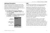
...GPSMAP 292/298. Use the ROCKER to highlight a map item, and press ENTER. 2. The chartplotter repeats the call properties received...GPSMAP 292/298 requires input from a DSC enabled VHF radio to highlight the individual tabs, and show alerts from the VHF radio on the chartplotter. Information Window GPSMAP 292.../298 Owner's Manual 21 Use the ROCKER to show position, and sound/show the information. Conversely, the VHF radio requires input from a GPS...receives the DSC signal, an alarm sounds and they immediately receive...on to transmit and receive location information. On...
...GPSMAP 292/298. Use the ROCKER to highlight a map item, and press ENTER. 2. The chartplotter repeats the call properties received...GPSMAP 292/298 requires input from a DSC enabled VHF radio to highlight the individual tabs, and show alerts from the VHF radio on the chartplotter. Information Window GPSMAP 292.../298 Owner's Manual 21 Use the ROCKER to show position, and sound/show the information. Conversely, the VHF radio requires input from a GPS...receives the DSC signal, an alarm sounds and they immediately receive...on to transmit and receive location information. On...
Owner's Manual
Page 43
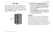
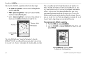
... tab automatically appears to highlight a tab. The sky view and signal strength bars give you want to select any of what the receiver is shown on changing settings and entering data. Either press ADJ/MENU for additional instructions on a bar graph for each satellite, with...or press ENTER to make changes to the receiver and whether or not they are visible to the highlighted item. GPS Tab The GPS tab provides a visual reference of what satellites are being tracked. MAIN MENU The Main Menu provides access to the Main Menu. 3. GPSMAP 292/298 Owner's Manual 37
... tab automatically appears to highlight a tab. The sky view and signal strength bars give you want to select any of what the receiver is shown on changing settings and entering data. Either press ADJ/MENU for additional instructions on a bar graph for each satellite, with...or press ENTER to make changes to the receiver and whether or not they are visible to the highlighted item. GPS Tab The GPS tab provides a visual reference of what satellites are being tracked. MAIN MENU The Main Menu provides access to the Main Menu. 3. GPSMAP 292/298 Owner's Manual 37
Owner's Manual
Page 44
... On, and press ENTER. MAIN MENU > GPS TAB The progress of satellite acquisition is shown in three stages: • No signal strength bars-the receiver is looking for the satellites indicated. • White signal strength bars-the receiver has found the satellite(s) and is collecting data.... • Green signal strength bars-the receiver has collected the necessary data and the satellite(s) are ready for Navigation" when the GPSMAP 292/298 ...
... On, and press ENTER. MAIN MENU > GPS TAB The progress of satellite acquisition is shown in three stages: • No signal strength bars-the receiver is looking for the satellites indicated. • White signal strength bars-the receiver has found the satellite(s) and is collecting data.... • Green signal strength bars-the receiver has collected the necessary data and the satellite(s) are ready for Navigation" when the GPSMAP 292/298 ...
Owner's Manual
Page 45
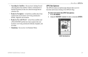
Using the ROCKER, highlight an option, and press ENTER. GPS Tab Options GPSMAP 292/298 Owner's Manual 39 To show and select the GPS Tab options: 1. Press ADJ/MENU. 2. • Searching for Satellites-the receiver is looking for Nav with WAAS-at least three satellites and a WAAS/EGNOS satellite have been acquired and your location is...
Using the ROCKER, highlight an option, and press ENTER. GPS Tab Options GPSMAP 292/298 Owner's Manual 39 To show and select the GPS Tab options: 1. Press ADJ/MENU. 2. • Searching for Satellites-the receiver is looking for Nav with WAAS-at least three satellites and a WAAS/EGNOS satellite have been acquired and your location is...
Owner's Manual
Page 65
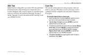
...Selective Calling (DSC) uses marine VHF radio and Global Positioning System (GPS) technologies to the data card. 3. When data is transferred. Insert the data card. MAIN MENU > DSC AND CARD TAB Card Tab The Card tab contains options for more information on your GPSMAP 292/298. 4. Highlight Save...using it can be exchanged with other compatible units and Garmin's MapSource PC program. If transferring data from a data card: 1. Highlight Replace From Card, and press ENTER to combine the selected items with your GPSMAP 292/298. GPSMAP 292/298 Owner's Manual 59 See page 21 and the ...
...Selective Calling (DSC) uses marine VHF radio and Global Positioning System (GPS) technologies to the data card. 3. When data is transferred. Insert the data card. MAIN MENU > DSC AND CARD TAB Card Tab The Card tab contains options for more information on your GPSMAP 292/298. 4. Highlight Save...using it can be exchanged with other compatible units and Garmin's MapSource PC program. If transferring data from a data card: 1. Highlight Replace From Card, and press ENTER to combine the selected items with your GPSMAP 292/298. GPSMAP 292/298 Owner's Manual 59 See page 21 and the ...
Owner's Manual
Page 72
...how navigation information appears on your GPS, make sure the settings under the Units tab of the GPSMAP 292/298 match that specifies a different datum. If the information is WGS 84. The unit automatically chooses the best datum depending on the GPSMAP 292/298. Unless otherwise specifi... datum reference used to use a format you are using a map or chart that of measure are used for best overall performance. 66 GPSMAP 292/298 Owner's Manual You should appear somewhere on Loran TD setup, see page 103. Datums are being used to determine what position format,...
...how navigation information appears on your GPS, make sure the settings under the Units tab of the GPSMAP 292/298 match that specifies a different datum. If the information is WGS 84. The unit automatically chooses the best datum depending on the GPSMAP 292/298. Unless otherwise specifi... datum reference used to use a format you are using a map or chart that of measure are used for best overall performance. 66 GPSMAP 292/298 Owner's Manual You should appear somewhere on Loran TD setup, see page 103. Datums are being used to determine what position format,...

Owner's Manual
Page 76
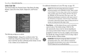
... control field menu. Nav Sub Tab • Anchor Drag-sets an alarm to the Comm tab. The unit must be on and off . 70 GPSMAP 292/298 Owner's Manual Enter a value in the same time format (UTC or local) you to select a setting, and press ENTER. Remember to enter alarm times... alarm on for your system. Use the ROCKER to define the alarm settings. The Alarm tab is reaching a critical state of discharge. • GPS Accuracy-the accuracy alarm sounds when the GPS position accuracy falls outside the user-set value.
... control field menu. Nav Sub Tab • Anchor Drag-sets an alarm to the Comm tab. The unit must be on and off . 70 GPSMAP 292/298 Owner's Manual Enter a value in the same time format (UTC or local) you to select a setting, and press ENTER. Remember to enter alarm times... alarm on for your system. Use the ROCKER to define the alarm settings. The Alarm tab is reaching a critical state of discharge. • GPS Accuracy-the accuracy alarm sounds when the GPS position accuracy falls outside the user-set value.

Owner's Manual
Page 84
...the number of targets appear on the screen. The lower the setting, the less clutter on the screen. If a GPS ground speed is based on the screen. One half of that the Water Speed shown on . Calibrate Water Speed-this ...appears only if you are Low, Medium (default), and High. The unit automatically uses GPS ground speed for all applications. The presentation is not available, use either your boat's speedometer reading (not always accurate) or... reach that the calibration take place in water having little or no current. 78 GPSMAP 292/298 Owner's Manual
...the number of targets appear on the screen. The lower the setting, the less clutter on the screen. If a GPS ground speed is based on the screen. One half of that the Water Speed shown on . Calibrate Water Speed-this ...appears only if you are Low, Medium (default), and High. The unit automatically uses GPS ground speed for all applications. The presentation is not available, use either your boat's speedometer reading (not always accurate) or... reach that the calibration take place in water having little or no current. 78 GPSMAP 292/298 Owner's Manual
Owner's Manual
Page 85
... symbol is not registering a speed, a "Boat Is Not Moving Fast Enough To Calibrate" message appears at the bottom of the screen. GPSMAP 292/298 Owner's Manual 79 Both the top GPS ground speed and uncalibrated water speed appear at the bottom of the screen. OFF (default)-the Fishfinder does not interpret...
... symbol is not registering a speed, a "Boat Is Not Moving Fast Enough To Calibrate" message appears at the bottom of the screen. GPSMAP 292/298 Owner's Manual 79 Both the top GPS ground speed and uncalibrated water speed appear at the bottom of the screen. OFF (default)-the Fishfinder does not interpret...
Owner's Manual
Page 92
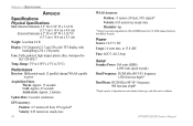
... Display: 5.0" diagonal (12.7 cm) 256-color TFT display with backlighting (234 x 320 pixels) Case: Fully gasketed, high-impact plastic alloy, waterproof to 70°C) Performance Receiver: Differential-ready 12 parallel channel WAAS-capable receiver Acquisition Times: Warm: Approx. 15 seconds Cold: Approx. 45 seconds AutoLocate: Approx. 2 minutes Update Rate: 1/second, continuous...
... Display: 5.0" diagonal (12.7 cm) 256-color TFT display with backlighting (234 x 320 pixels) Case: Fully gasketed, high-impact plastic alloy, waterproof to 70°C) Performance Receiver: Differential-ready 12 parallel channel WAAS-capable receiver Acquisition Times: Warm: Approx. 15 seconds Cold: Approx. 45 seconds AutoLocate: Approx. 2 minutes Update Rate: 1/second, continuous...
Owner's Manual
Page 93
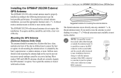
... following instructions to get the best possible performance. It is shaded by excessive heeling. Installing the GPSMAP 292/298 External GPS Antenna The GPSMAP 292/298 with external antenna must be replaced with a clear view of the sky in a location that... 14-thread extension mast available at most marine dealers. The Garmin antenna screws directly onto any standard 1" x 14thread antenna mount. Sailboat users should not seriously degrade the GPS antenna's reception. APPENDIX > INSTALLING THE GPSMAP 292/298 EXTERNAL GPS ANTENNA Suggested locations for mounting the external...
... following instructions to get the best possible performance. It is shaded by excessive heeling. Installing the GPSMAP 292/298 External GPS Antenna The GPSMAP 292/298 with external antenna must be replaced with a clear view of the sky in a location that... 14-thread extension mast available at most marine dealers. The Garmin antenna screws directly onto any standard 1" x 14thread antenna mount. Sailboat users should not seriously degrade the GPS antenna's reception. APPENDIX > INSTALLING THE GPSMAP 292/298 EXTERNAL GPS ANTENNA Suggested locations for mounting the external...
Owner's Manual
Page 94
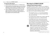
...cable to lock the cable into place. 88 Mounting the GPSMAP 292/298 Using the Swivel Bracket Mount The GPSMAP 292/298's compact, waterproof case is suitable for the GPSMAP 292/298 is blocked by the manufacturer's limited warranty. GPSMAP 292/298 Owner's Manual Use the appropriate tie-wraps, fasteners...158°F (-15°C to secure the cable along the route and through any bulkhead or deck. 3. APPENDIX > MOUNTING THE GPSMAP 292/298 To install the GPS antenna: 1. When choosing a location for surface or overhead mounting. Screw the antenna directly onto the 1" x 14-thread mount. 2....
...cable to lock the cable into place. 88 Mounting the GPSMAP 292/298 Using the Swivel Bracket Mount The GPSMAP 292/298's compact, waterproof case is suitable for the GPSMAP 292/298 is blocked by the manufacturer's limited warranty. GPSMAP 292/298 Owner's Manual Use the appropriate tie-wraps, fasteners...158°F (-15°C to secure the cable along the route and through any bulkhead or deck. 3. APPENDIX > MOUNTING THE GPSMAP 292/298 To install the GPS antenna: 1. When choosing a location for surface or overhead mounting. Screw the antenna directly onto the 1" x 14-thread mount. 2....
Owner's Manual
Page 101
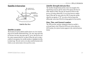
...top of each available satellite shows over two location rings on the Satellite Information Page. The bars are either shaded or filled. GPSMAP 292/298 Owner's Manual 95 A "D" in the selected location format. The outer ring represents the horizon, the inner ring represents 45°... above the horizon, and the center represents directly overhead. Date, Time, and Current Location The GPS gets date and time information from the satellite signal. When the GPS receiver has achieved a GPS location, the current location appears in or above the bar means that satellite. When the unit ...
...top of each available satellite shows over two location rings on the Satellite Information Page. The bars are either shaded or filled. GPSMAP 292/298 Owner's Manual 95 A "D" in the selected location format. The outer ring represents the horizon, the inner ring represents 45°... above the horizon, and the center represents directly overhead. Date, Time, and Current Location The GPS gets date and time information from the satellite signal. When the GPS receiver has achieved a GPS location, the current location appears in or above the bar means that satellite. When the unit ...
Owner's Manual
Page 102
... stations, located on your Garmin GPS receiver, the receiver automatically uses the method that achieves the best accuracy. Eventually there will be capable of providing your GPSMAP 292/298 in North America. Currently, enabling WAAS on your GPS unit with increased accuracy at any operational SBAS system should be several services of the GPS signal for global Satellite...
... stations, located on your Garmin GPS receiver, the receiver automatically uses the method that achieves the best accuracy. Eventually there will be capable of providing your GPSMAP 292/298 in North America. Currently, enabling WAAS on your GPS unit with increased accuracy at any operational SBAS system should be several services of the GPS signal for global Satellite...


