Owner's Manual
Page 9
...accuracy and performance of all data sources contain inaccurate or incomplete data to some degree. The system is a precision electronic NAVigation AID (NAVAID), any questions or would like additional information, please refer to our web site at a reasonable cost. Virtually all GPS equipment. Although the Garmin GPS 60... is subject to changes which we identify as required in accordance with the most complete and accurate cartography that is available to us at http://www.garmin. com/prop65. This is particularly...
...accuracy and performance of all data sources contain inaccurate or incomplete data to some degree. The system is a precision electronic NAVigation AID (NAVAID), any questions or would like additional information, please refer to our web site at a reasonable cost. Virtually all GPS equipment. Although the Garmin GPS 60... is subject to changes which we identify as required in accordance with the most complete and accurate cartography that is available to us at http://www.garmin. com/prop65. This is particularly...
Owner's Manual
Page 18
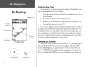
... routes (see p. 33). Accuracy Circle Panning Arrow 8 Zooming and Panning To zoom in far enough, you zoom in or out, press the IN and OUT keys. A zoom scale appears in the lower left corner of the Map Page. To pan the map (view other parts of the GPS 60. You can use the...
... routes (see p. 33). Accuracy Circle Panning Arrow 8 Zooming and Panning To zoom in far enough, you zoom in or out, press the IN and OUT keys. A zoom scale appears in the lower left corner of the Map Page. To pan the map (view other parts of the GPS 60. You can use the...

Owner's Manual
Page 28
... options menu. GPGSPSNNaavviiggaattiioonn Waypoints The Average Location Page As you watch, notice that the number in the 'Estimated Accuracy' field decreases as the GPS 60 calculates a more accurate location for the waypoint. Calculation begins automatically. 2. As you wait, the waypoint position ... 2. To average a waypoint location over time to save the waypoint. Averaging Waypoint Location The GPS 60 can change the waypoint name, map symbol, location coordi- Wait as the GPS 60 takes more accurate. Press FIND, select 'Waypoints,' and open an existing waypoint (see "Finding...
... options menu. GPGSPSNNaavviiggaattiioonn Waypoints The Average Location Page As you watch, notice that the number in the 'Estimated Accuracy' field decreases as the GPS 60 calculates a more accurate location for the waypoint. Calculation begins automatically. 2. As you wait, the waypoint position ... 2. To average a waypoint location over time to save the waypoint. Averaging Waypoint Location The GPS 60 can change the waypoint name, map symbol, location coordi- Wait as the GPS 60 takes more accurate. Press FIND, select 'Waypoints,' and open an existing waypoint (see "Finding...

Owner's Manual
Page 72
... Keypad: Nine multifunction backlit keys Operating Range: 5 to 158oF (-15 to 70oC)1 Performance Receiver: WAAS enabled, 12 parallel channel Acquisition Time: Warm: Approximately 15 seconds Cold: Approximately 45 seconds AutoLocate™: Approximately 2 minutes Update Rate: Once per second, continuous GPS Accuracy Position: < 15 meters (49 feet), 95% typical2 Velocity: 0.05 meter/sec steady...
... Keypad: Nine multifunction backlit keys Operating Range: 5 to 158oF (-15 to 70oC)1 Performance Receiver: WAAS enabled, 12 parallel channel Acquisition Time: Warm: Approximately 15 seconds Cold: Approximately 45 seconds AutoLocate™: Approximately 2 minutes Update Rate: Once per second, continuous GPS Accuracy Position: < 15 meters (49 feet), 95% typical2 Velocity: 0.05 meter/sec steady...
Owner's Manual
Page 73
... Internal; Subject to accuracy degradation to 100m 2DRMS under the U.S. DoD imposed Selective Availability (SA) Program. 3. Extensive use of their capacity as the temperature decreases. Some batteries can rupture at high temperatures. 2. With optional Garmin GBR 21 Beacon Receiver input. 4. Alkaline... batteries lose a significant amount of screen backlighting and/or audible tones significantly reduces battery life. 63 The temperature rating of the GPS 60 may exceed the usable range...
... Internal; Subject to accuracy degradation to 100m 2DRMS under the U.S. DoD imposed Selective Availability (SA) Program. 3. Extensive use of their capacity as the temperature decreases. Some batteries can rupture at high temperatures. 2. With optional Garmin GBR 21 Beacon Receiver input. 4. Alkaline... batteries lose a significant amount of screen backlighting and/or audible tones significantly reduces battery life. 63 The temperature rating of the GPS 60 may exceed the usable range...

Owner's Manual
Page 74
Distance To Destination-The entire distance, from sonar NMEA input. Distance To Next-The distance to your GPS 60. ETA At Next-The estimated time that you will arrive at your destination, if you maintain your current speed and course. ...of your current position to vertical distance. 64 ETA At Destination-The estimated time that you will arrive at the next point on a route. Accuracy GPS-The current accuracy of a route. Bearing-The compass direction from your destination point. Course-The desired path of each data field option. AAppppeennddiicceess Appendix ...
Distance To Destination-The entire distance, from sonar NMEA input. Distance To Next-The distance to your GPS 60. ETA At Next-The estimated time that you will arrive at your destination, if you maintain your current speed and course. ...of your current position to vertical distance. 64 ETA At Destination-The estimated time that you will arrive at the next point on a route. Accuracy GPS-The current accuracy of a route. Bearing-The compass direction from your destination point. Course-The desired path of each data field option. AAppppeennddiicceess Appendix ...

Owner's Manual
Page 82
...developmental stage with a goal of providing reliable signals with an accuracy of 7 meters (21-22 ft.) both horizontally and vertically 95% of GPS by ground reference stations (see DGPS below). funded project to http://gps.faa.gov/Programs/WAAS/waas.htm. They are operational in ... Selective Availability (SA) program. The U.S. and Canadian governments (among others) have shown the actual accuracy to compensating for errors in coastal areas and on the order of the GPS signal. For more information, go to improve the overall integrity of 2-3 meters. Appendices Appendix G: ...
...developmental stage with a goal of providing reliable signals with an accuracy of 7 meters (21-22 ft.) both horizontally and vertically 95% of GPS by ground reference stations (see DGPS below). funded project to http://gps.faa.gov/Programs/WAAS/waas.htm. They are operational in ... Selective Availability (SA) program. The U.S. and Canadian governments (among others) have shown the actual accuracy to compensating for errors in coastal areas and on the order of the GPS signal. For more information, go to improve the overall integrity of 2-3 meters. Appendices Appendix G: ...
