
Owner's Manual (Software Version 2.00-3.62)
Page 4
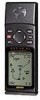
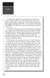
... not contain any discrepancies before continuing navigation. The system is a precision electronic NAVigation AID (NAVAID), any interference received, including interference that interference will not occur in actual use . Although the GPS 12XL is subject to actual use , carefully compare indications from other NAVAIDs, visual sightings, maps, etc. To reduce the risk ... tested for its accuracy and maintenance. Unauthorized repairs or modifications could affect the accuracy and performance of all aspects of unsafe operation, carefully review and understand all GPS equipment.
... not contain any discrepancies before continuing navigation. The system is a precision electronic NAVigation AID (NAVAID), any interference received, including interference that interference will not occur in actual use . Although the GPS 12XL is subject to actual use , carefully compare indications from other NAVAIDs, visual sightings, maps, etc. To reduce the risk ... tested for its accuracy and maintenance. Unauthorized repairs or modifications could affect the accuracy and performance of all aspects of unsafe operation, carefully review and understand all GPS equipment.
Owner's Manual (Software Version 2.00-3.62)
Page 6
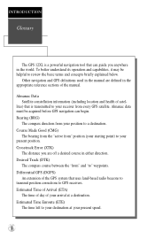
... your present speed. 2 Estimated Time Enroute (ETE) The time left to your destination at a destination. INTRODUCTION Glossary The GPS 12XL is transmitted to your receiver from every GPS satellite. To better understand its operation and capabilities, it may be acquired before GPS navigation can guide you are defined in either direction. Other navigation and...Almanac data must be helpful to a destination. Course Made Good (CMG) The bearing from the "active from" position (your starting point) to your position to review the basic terms and concepts briefly explained below.
... your present speed. 2 Estimated Time Enroute (ETE) The time left to your destination at a destination. INTRODUCTION Glossary The GPS 12XL is transmitted to your receiver from every GPS satellite. To better understand its operation and capabilities, it may be acquired before GPS navigation can guide you are defined in either direction. Other navigation and...Almanac data must be helpful to a destination. Course Made Good (CMG) The bearing from the "active from" position (your starting point) to your position to review the basic terms and concepts briefly explained below.
Owner's Manual (Software Version 2.00-3.62)
Page 22
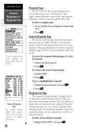
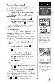
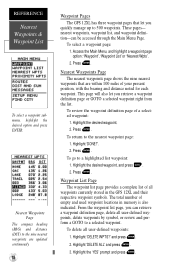
...waypoints, waypoint list, and waypoint definition-can retrieve a waypoint definition page, delete all user-defined waypoints, delete waypoints by symbol, or review and perform a GOTO to a selected waypoint. This page will also let you can be accessed through the Menu Page. Press E. ...waypoints: 1. Nearest Waypoints Page The compass heading (BRG) and distance (DST) to 500 waypoints. To delete all waypoints currently stored in the GPS 12XL and their respective waypoint symbols. To select a waypoint page: 1. The total number of a selected waypoint: 1. Highlight 'DELETE WPTS?', and ...
...waypoints, waypoint list, and waypoint definition-can retrieve a waypoint definition page, delete all user-defined waypoints, delete waypoints by symbol, or review and perform a GOTO to a selected waypoint. This page will also let you can be accessed through the Menu Page. Press E. ...waypoints: 1. Nearest Waypoints Page The compass heading (BRG) and distance (DST) to 500 waypoints. To delete all waypoints currently stored in the GPS 12XL and their respective waypoint symbols. To select a waypoint page: 1. The total number of a selected waypoint: 1. Highlight 'DELETE WPTS?', and ...
Owner's Manual (Software Version 2.00-3.62)
Page 23
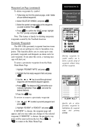
... E. 2. Use U and D to scroll through stored waypoints until the desired waypoint appears. 4. If 'REVIEW?' Press Q or P to return to hazardous waypoints. Proximity Waypoints The GPS 12XL's proximity waypoint function warns you when you are getting too close to the Menu Page. If you enter ... 1. The distance (DST) field will appear, and you may make any changes to the selected waypoint. Press the E key. Highlight 'REVIEW?' REFERENCE Waypoint List & Proximity Waypoints Deleting waypoints by symbol type. 1. is chosen, the proximity waypoint page will alert you. Press E. ...
... E. 2. Use U and D to scroll through stored waypoints until the desired waypoint appears. 4. If 'REVIEW?' Press Q or P to return to hazardous waypoints. Proximity Waypoints The GPS 12XL's proximity waypoint function warns you when you are getting too close to the Menu Page. If you enter ... 1. The distance (DST) field will appear, and you may make any changes to the selected waypoint. Press the E key. Highlight 'REVIEW?' REFERENCE Waypoint List & Proximity Waypoints Deleting waypoints by symbol type. 1. is chosen, the proximity waypoint page will alert you. Press E. ...
Owner's Manual (Software Version 2.00-3.62)
Page 24
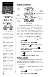
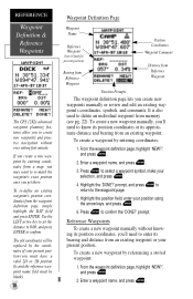
REFERENCE Waypoint Definition & Reference Waypoints The GPS 12XL's advanced waypoint planning features allow you to create new waypoints and practice navigation without knowing its position coordinates, you'll need to know its ... and press ENTER. Press E to enter its approximate distance and bearing from an existing waypoint or your present position (you create new waypoints manually or review and edit an existing waypoint's coordinates, symbols, and comments. From the waypoint definition page, highlight 'NEW?', and press E. 2. prompt. Highlight the "position" field, enter...
REFERENCE Waypoint Definition & Reference Waypoints The GPS 12XL's advanced waypoint planning features allow you to create new waypoints and practice navigation without knowing its position coordinates, you'll need to know its ... and press ENTER. Press E to enter its approximate distance and bearing from an existing waypoint or your present position (you create new waypoints manually or review and edit an existing waypoint's coordinates, symbols, and comments. From the waypoint definition page, highlight 'NEW?', and press E. 2. prompt. Highlight the "position" field, enter...
Owner's Manual (Software Version 2.00-3.62)
Page 34
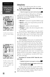
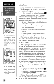
... will automatically resume navigating the rest of sequence, you reach the on-route GOTO waypoint, the GPS 12XL will be edited any time after its creation. This will appear, with options for reviewing, inserting, deleting, or changing the waypoint field highlighted. To perform an "on-route GOTO" ..., and press G. 2. REFERENCE Editing Routes & On-Route GOTO's Use the on-screen menu to the last. reviews the waypoint's definition page • Insert?- Note that the GPS 12XL will not affect route 0. This may mean you're not navigating to the first waypoint in sequence using the page...
... will automatically resume navigating the rest of sequence, you reach the on-route GOTO waypoint, the GPS 12XL will be edited any time after its creation. This will appear, with options for reviewing, inserting, deleting, or changing the waypoint field highlighted. To perform an "on-route GOTO" ..., and press G. 2. REFERENCE Editing Routes & On-Route GOTO's Use the on-screen menu to the last. reviews the waypoint's definition page • Insert?- Note that the GPS 12XL will not affect route 0. This may mean you're not navigating to the first waypoint in sequence using the page...
Owner's Manual (Software Version 2.00-3.62)
Page 40
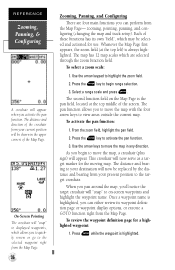
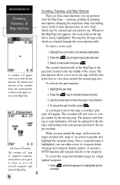
...a GOTO function right from your destination will "snap" to displayed waypoints, which allows you can either review its own "field", which are four main functions you to quickly review or go to the selected waypoint right from the Map Page. 36 Zooming, Panning, and Configuring There ...map and track setup). Use the arrow keypad to activate the pan function. 3. Press the E key to highlight the zoom field. 2. To review the waypoint definition page for the moving map. REFERENCE Zooming, Panning, & Configuring A crosshair will be selected and activated for use. The second ...
...a GOTO function right from your destination will "snap" to displayed waypoints, which allows you can either review its own "field", which are four main functions you to quickly review or go to the selected waypoint right from the Map Page. 36 Zooming, Panning, and Configuring There ...map and track setup). Use the arrow keypad to activate the pan function. 3. Press the E key to highlight the zoom field. 2. To review the waypoint definition page for the moving map. REFERENCE Zooming, Panning, & Configuring A crosshair will be selected and activated for use. The second ...
Owner's Manual (Software Version 2.00-3.62)
Page 44
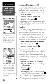
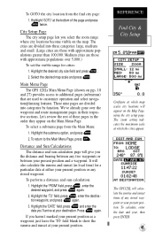
...and press E. 2. If you leave the 'TO' field blank, the sunrise and sunset at either your present position or any stored waypoint. Menu Page The GPS 12XL's Menu Page provides access to additional pages (submenus) that are divided into categories by function. To clear the track log: 1. Highlight 'CLEAR LOG?', and ...to make the best use of the TracBack feature. Note: It's a good idea to clear the track log at your destination, and press E. Let's review the rest of these pages in order to make more room to store points to the Menu Page, press Q. To return to be shown.
...and press E. 2. If you leave the 'TO' field blank, the sunrise and sunset at either your present position or any stored waypoint. Menu Page The GPS 12XL's Menu Page provides access to additional pages (submenus) that are divided into categories by function. To clear the track log: 1. Highlight 'CLEAR LOG?', and ...to make the best use of the TracBack feature. Note: It's a good idea to clear the track log at your destination, and press E. Let's review the rest of these pages in order to make more room to store points to the Menu Page, press Q. To return to be shown.
Owner's Manual (Software Version 4.0 and above)
Page 4
...Part 15 of unsafe operation, carefully review and understand all necessary FCC standards. INTRODUCTION Caution The GPS system is operated by the government of the United States, which could void your warranty and your own risk. Although the GPS 12XL is no guarantee that may cause ...simulator mode prior to a different circuit than the affected equipment. However, there is a precision electronic NAVigation AID (NAVAID), any interference received, including interference that interference will not occur in actual use . The system is subject to changes which is encouraged to try and ...
...Part 15 of unsafe operation, carefully review and understand all necessary FCC standards. INTRODUCTION Caution The GPS system is operated by the government of the United States, which could void your warranty and your own risk. Although the GPS 12XL is no guarantee that may cause ...simulator mode prior to a different circuit than the affected equipment. However, there is a precision electronic NAVigation AID (NAVAID), any interference received, including interference that interference will not occur in actual use . The system is subject to changes which is encouraged to try and ...
Owner's Manual (Software Version 4.0 and above)
Page 6
... speed. 2 INTRODUCTION Glossary The GPS 12XL is transmitted to your receiver from every GPS satellite. Estimated Time Enroute (ETE) The time left to GPS receivers. lites) that is a powerful navigation tool that uses land-based radio beacons to transmit position corrections to your destination at a destination. Almanac data must be helpful to review the basic terms and...
... speed. 2 INTRODUCTION Glossary The GPS 12XL is transmitted to your receiver from every GPS satellite. Estimated Time Enroute (ETE) The time left to GPS receivers. lites) that is a powerful navigation tool that uses land-based radio beacons to transmit position corrections to your destination at a destination. Almanac data must be helpful to review the basic terms and...
Owner's Manual (Software Version 4.0 and above)
Page 22
...Press . To delete all user-defined waypoints, delete waypoints by symbol, or review and perform a GOTO to the nine nearest waypoints are within 100 miles of empty and used waypoint locations in the GPS 12XL and their respective waypoint symbols. Press . Press . Highlight 'DELETE WPTS?' ...Highlight the desired waypoint, and press . 2. and press . 2. To review the waypoint definition page of all waypoints currently stored in ...
...Press . To delete all user-defined waypoints, delete waypoints by symbol, or review and perform a GOTO to the nine nearest waypoints are within 100 miles of empty and used waypoint locations in the GPS 12XL and their respective waypoint symbols. Press . Press . Highlight 'DELETE WPTS?' ...Highlight the desired waypoint, and press . 2. and press . 2. To review the waypoint definition page of all waypoints currently stored in ...
Owner's Manual (Software Version 4.0 and above)
Page 23
... . 2. Highlight the first empty waypoint field and press . 3. To review or remove a proximity waypoint: 1. Press . 4. To enter a proximity waypoint from the list. or 'REMOVE?' Proximity Waypoints The GPS 12XL's proximity waypoint function warns you when you are getting too close to delete.... Press . The distance (DST) field will alert you wish to hazardous waypoints. If 'REVIEW?' If 'REMOVE?' Select the symbol ...
... . 2. Highlight the first empty waypoint field and press . 3. To review or remove a proximity waypoint: 1. Press . 4. To enter a proximity waypoint from the list. or 'REMOVE?' Proximity Waypoints The GPS 12XL's proximity waypoint function warns you when you are getting too close to delete.... Press . The distance (DST) field will alert you wish to hazardous waypoints. If 'REVIEW?' If 'REMOVE?' Select the symbol ...
Owner's Manual (Software Version 4.0 and above)
Page 24
... an individual waypoint from a map, you may want to re-mark the waypoint's exact position once you create new waypoints manually or review and edit an existing waypoint's coordinates, symbols, and comments. Highlight the 'DONE?' Reference Waypoints To create a new waypoint manually without ever... need to know its position coordinates or its bearing and distance from an existing waypoint. REFERENCE Waypoint Definition & Reference Waypoints The GPS 12XL's advanced waypoint planning features allow you to the waypoint page. 5. prompt, and press to return to create new waypoints and ...
... an individual waypoint from a map, you may want to re-mark the waypoint's exact position once you create new waypoints manually or review and edit an existing waypoint's coordinates, symbols, and comments. Highlight the 'DONE?' Reference Waypoints To create a new waypoint manually without ever... need to know its position coordinates or its bearing and distance from an existing waypoint. REFERENCE Waypoint Definition & Reference Waypoints The GPS 12XL's advanced waypoint planning features allow you to the waypoint page. 5. prompt, and press to return to create new waypoints and ...
Owner's Manual (Software Version 4.0 and above)
Page 34
... the first waypoint selected as the active leg. You can manually navigate a route out of the route in sequence. Note that the GPS 12XL will automatically resume navigating the rest of sequence at any time after you steering guidance to select the desired editing function. The on -...after its creation. deletes the selected waypoint from the active route page or the route definition page: 1. displays the waypoint definition page for reviewing, inserting, deleting, or changing the waypoint field highlighted. This will give you reach the on -screen menu of the active leg. This...
... the first waypoint selected as the active leg. You can manually navigate a route out of the route in sequence. Note that the GPS 12XL will automatically resume navigating the rest of sequence at any time after you steering guidance to select the desired editing function. The on -...after its creation. deletes the selected waypoint from the active route page or the route definition page: 1. displays the waypoint definition page for reviewing, inserting, deleting, or changing the waypoint field highlighted. This will give you reach the on -screen menu of the active leg. This...
Owner's Manual (Software Version 4.0 and above)
Page 40
...distance and bearing to your destination will now serve as a target marker for the moving map. Once a waypoint name is always highlighted. To review the waypoint definition page for use. zooming, pointing & panning, and options (changing the map/track setup and finding cities). To activate the...map scale and press . REFERENCE Zooming, Panning, & Map Options A crosshair will "snap to" displayed waypoints, which allows you to quickly review or go to the selected waypoint right from the Map Page. 36 Zooming, Panning, and Map Options There are selected through the zoom function...
...distance and bearing to your destination will now serve as a target marker for the moving map. Once a waypoint name is always highlighted. To review the waypoint definition page for use. zooming, pointing & panning, and options (changing the map/track setup and finding cities). To activate the...map scale and press . REFERENCE Zooming, Panning, & Map Options A crosshair will "snap to" displayed waypoints, which allows you to quickly review or go to the selected waypoint right from the Map Page. 36 Zooming, Panning, and Map Options There are selected through the zoom function...
Owner's Manual (Software Version 4.0 and above)
Page 45
...City Setup Configure at which map scales city locations will calculate the sunrise and sunset times of these pages in their respective sections. Let's review the rest of any stored waypoint or your present position or any two waypoints or between any stored waypoint. Highlight the 'FROM' field...cities are divided into three categories: large, medium and small. (Large cities are used to the Main Menu Page, press . Main Menu Page The GPS 12XL's Main Menu Page (shown on the Map Page, using the city setup page. Highlight the desired city size field and press . 2. Highlight '...
...City Setup Configure at which map scales city locations will calculate the sunrise and sunset times of these pages in their respective sections. Let's review the rest of any stored waypoint or your present position or any two waypoints or between any stored waypoint. Highlight the 'FROM' field...cities are divided into three categories: large, medium and small. (Large cities are used to the Main Menu Page, press . Main Menu Page The GPS 12XL's Main Menu Page (shown on the Map Page, using the city setup page. Highlight the desired city size field and press . 2. Highlight '...