Owner's Manual
Page 10
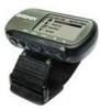
... unit. It is waterproof to MapSource). viii Do not machine wash. Clean the unit using this guide, contact Garmin Product Support in Water The Foretrex 201 is always a good practice to back up important user data by manually recording it or downloading it to a PC (transferring it to IEC Standard 60529 IPX7. After submersion, be...
... unit. It is waterproof to MapSource). viii Do not machine wash. Clean the unit using this guide, contact Garmin Product Support in Water The Foretrex 201 is always a good practice to back up important user data by manually recording it or downloading it to a PC (transferring it to IEC Standard 60529 IPX7. After submersion, be...
Owner's Manual
Page 59
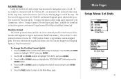
... 47 Choose from 11 other position formats or choose the 'USER' position format to highlight 'SET UNITS' and press ENTER. 3. For more information about using paper maps with your Garmin unit, refer to "Using a Garmin GPS with Paper Land Maps", available for download at http://www....and datum, visit the National Imagery and Mapping Agency at http://www.garmin.com/manuals/UsingaGarmtinGPSwithPaperLandMaps_Manual.pdf. Press the UP or DOWN button to the Main Menu page. Set Units Page Using the Foretrex 201 with the Foretrex 201, you must select the position format, map datum, map units, ...
... 47 Choose from 11 other position formats or choose the 'USER' position format to highlight 'SET UNITS' and press ENTER. 3. For more information about using paper maps with your Garmin unit, refer to "Using a Garmin GPS with Paper Land Maps", available for download at http://www....and datum, visit the National Imagery and Mapping Agency at http://www.garmin.com/manuals/UsingaGarmtinGPSwithPaperLandMaps_Manual.pdf. Press the UP or DOWN button to the Main Menu page. Set Units Page Using the Foretrex 201 with the Foretrex 201, you must select the position format, map datum, map units, ...

Owner's Manual
Page 62
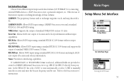
...ENTER to set the angle units and the North Reference in which 17.78 mils equal one . Maps are using one degree. If 'User' is usually small enough that 'Grid' north can set the unit's System settings to the 'north pole'. Select from any location on...difference between true and magnetic north with True North, the direction from True North, Magnetic North, Grid North, or User North. Magnetic North is called variation. If necessary, manually correct for complete information. Refer to match the North Reference used in military settings, in . North Reference 'Reference' ...
...ENTER to set the angle units and the North Reference in which 17.78 mils equal one . Maps are using one degree. If 'User' is usually small enough that 'Grid' north can set the unit's System settings to the 'north pole'. Select from any location on...difference between true and magnetic north with True North, the direction from True North, Magnetic North, Grid North, or User North. Magnetic North is called variation. If necessary, manually correct for complete information. Refer to match the North Reference used in military settings, in . North Reference 'Reference' ...
Owner's Manual
Page 63
... Text Out: Allows ASCII text output of standard NMEA 0183 version 3.0 data. If 'GARMIN DGPS' or 'RTCM/NMEA' format is selected, additional fields are provided to manually tune the receiver and enter the beacon frequency and bit rate. In the 'BEACON' list, select '...SCAN' to tune automatically, or select 'USER' to control a GARMIN differential beacon receiver (e.g. NMEA Out: Supports the output of location and ...
... Text Out: Allows ASCII text output of standard NMEA 0183 version 3.0 data. If 'GARMIN DGPS' or 'RTCM/NMEA' format is selected, additional fields are provided to manually tune the receiver and enter the beacon frequency and bit rate. In the 'BEACON' list, select '...SCAN' to tune automatically, or select 'USER' to control a GARMIN differential beacon receiver (e.g. NMEA Out: Supports the output of location and ...

