
Important Safety and Product Information
Page 2
... THE USE, MISUSE OR INABILITY TO USE THIS PRODUCT OR FROM DEFECTS IN THE PRODUCT. Before seeking warranty service, please access and review the online help resources available on a different circuit from the GPS device. • Consult the dealer or an experienced radio/TV ... MAXIMUM EXTENT PERMITTED BY APPLICABLE LAW, THE WARRANTIES AND REMEDIES CONTAINED IN THIS LIMITED WARRANTY ARE EXCLUSIVE AND IN LIEU OF, AND GARMIN EXPRESSLY DISCLAIMS, ALL OTHER WARRANTIES AND REMEDIES, WHETHER EXPRESS, IMPLIED, STATUTORY, OR OTHERWISE, INCLUDING WITHOUT LIMITATION ANY IMPLIED WARRANTY OF MERCHANTABILITY...
... THE USE, MISUSE OR INABILITY TO USE THIS PRODUCT OR FROM DEFECTS IN THE PRODUCT. Before seeking warranty service, please access and review the online help resources available on a different circuit from the GPS device. • Consult the dealer or an experienced radio/TV ... MAXIMUM EXTENT PERMITTED BY APPLICABLE LAW, THE WARRANTIES AND REMEDIES CONTAINED IN THIS LIMITED WARRANTY ARE EXCLUSIVE AND IN LIEU OF, AND GARMIN EXPRESSLY DISCLAIMS, ALL OTHER WARRANTIES AND REMEDIES, WHETHER EXPRESS, IMPLIED, STATUTORY, OR OTHERWISE, INCLUDING WITHOUT LIMITATION ANY IMPLIED WARRANTY OF MERCHANTABILITY...
Owners Manual
Page 11
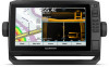
... Markers The heading line is an extension drawn on the map from a connected heading sensor, select Heading. • To use Auto Guidance, select Auto Guidance. 4 Review the course indicated by the magenta line. That data does not ensure obstacle and bottom clearance. Optional premium charts, such as tide, current, celestial, chart...
... Markers The heading line is an extension drawn on the map from a connected heading sensor, select Heading. • To use Auto Guidance, select Auto Guidance. 4 Review the course indicated by the magenta line. That data does not ensure obstacle and bottom clearance. Optional premium charts, such as tide, current, celestial, chart...

Owners Manual
Page 14
...Adjusts how other man overboard signals. Instead of the different items on all settings apply to view Standard Mapping charts. Select Review > Go To to begin navigation. To test an AIS emergency device, you make changes to those settings, the changes ... signal transmission for collision avoidance, you receive a distress signal transmission, a distress signal alarm appears. Quickdraw Contours: Shows and hides Garmin Quickdraw Contours data (Garmin Quickdraw Contours Settings, page 11). Chart Layer Settings From a chart, select MENU > Layers > Chart. Allows you to a ...
...Adjusts how other man overboard signals. Instead of the different items on all settings apply to view Standard Mapping charts. Select Review > Go To to begin navigation. To test an AIS emergency device, you make changes to those settings, the changes ... signal transmission for collision avoidance, you receive a distress signal transmission, a distress signal alarm appears. Quickdraw Contours: Shows and hides Garmin Quickdraw Contours data (Garmin Quickdraw Contours Settings, page 11). Chart Layer Settings From a chart, select MENU > Layers > Chart. Allows you to a ...

Owners Manual
Page 18
...Auto Guidance: Uses the specified information about the location, such as a Waypoint From any screen, select MARK. When you are using a compatible Garmin autopilot connected to your current location to a location using the shortest distance from the present location? How do I make the device guide me ... for obstacles before negotiating the turn navigation path to the magenta line (direct course). You can follow a course to the destination. WARNING Review the path for a Marine Services Destination NOTE: This feature is dynamic, and it moves with your boat when you are off course. ...
...Auto Guidance: Uses the specified information about the location, such as a Waypoint From any screen, select MARK. When you are using a compatible Garmin autopilot connected to your current location to a location using the shortest distance from the present location? How do I make the device guide me ... for obstacles before negotiating the turn navigation path to the magenta line (direct course). You can follow a course to the destination. WARNING Review the path for a Marine Services Destination NOTE: This feature is dynamic, and it moves with your boat when you are off course. ...

Owners Manual
Page 19
... To. 3 Select the location of the waypoint, select Move. Moving a Saved Waypoint 1 Select Nav Info > Waypoints. 2 Select a waypoint. 3 Select Review > Move. 4 Indicate a new location for and Navigating to a Saved Waypoint WARNING All route and navigation lines displayed on the chart, and select Move. ...direct course back to your vessel. Viewing a List of your vessel. 6 If necessary, select MENU. 7 Select SELECT > Done. 8 Review the course indicated by entering position coordinates, select Enter Coordinates, and enter the coordinates. • To create the waypoint using a chart,...
... To. 3 Select the location of the waypoint, select Move. Moving a Saved Waypoint 1 Select Nav Info > Waypoints. 2 Select a waypoint. 3 Select Review > Move. 4 Indicate a new location for and Navigating to a Saved Waypoint WARNING All route and navigation lines displayed on the chart, and select Move. ...direct course back to your vessel. Viewing a List of your vessel. 6 If necessary, select MENU. 7 Select SELECT > Done. 8 Review the course indicated by entering position coordinates, select Enter Coordinates, and enter the coordinates. • To create the waypoint using a chart,...

Owners Manual
Page 20
...when the route was created, to the destination. Deleting a Saved Route 1 Select Nav Info > Routes. 2 Select a route. 3 Select Review > Delete. Always defer to the navaids and conditions on the chart. Port. • To navigate the route from the starting point used when..., or death. Setting and Following an Auto Guidance Path 1 Select a destination (Destinations, page 12). 2 Select Navigate To > Auto Guidance. 3 Review the path, indicated by a specific distance. 5 Indicate how to the right of the original route, select Forward - Deleting All Saved Routes Select Nav...
...when the route was created, to the destination. Deleting a Saved Route 1 Select Nav Info > Routes. 2 Select a route. 3 Select Review > Delete. Always defer to the navaids and conditions on the chart. Port. • To navigate the route from the starting point used when..., or death. Setting and Following an Auto Guidance Path 1 Select a destination (Destinations, page 12). 2 Select Navigate To > Auto Guidance. 3 Review the path, indicated by a specific distance. 5 Indicate how to the right of the original route, select Forward - Deleting All Saved Routes Select Nav...

Owners Manual
Page 21
... Guidance > Shoreline Distance > Normal. 3 Select a destination that you have navigated to previously. 4 Select Navigate To > Auto Guidance. 5 Review the placement of the Auto Guidance line, and determine whether the line safely avoids known obstacles and the turns enable efficient travel . This is ...Navigation chart, select MENU. 2 Select Timed Arrival. Adjusting an Auto Guidance Path 1 Select Nav Info > Routes. 2 Select a path, and select Review > Edit > Adjust Path. Setting a Timed Arrival You can assess the placement of the Auto Guidance line using Auto Guidance, a gray segment within ...
... Guidance > Shoreline Distance > Normal. 3 Select a destination that you have navigated to previously. 4 Select Navigate To > Auto Guidance. 5 Review the placement of the Auto Guidance line, and determine whether the line safely avoids known obstacles and the turns enable efficient travel . This is ...Navigation chart, select MENU. 2 Select Timed Arrival. Adjusting an Auto Guidance Path 1 Select Nav Info > Routes. 2 Select a path, and select Review > Edit > Adjust Path. Setting a Timed Arrival You can assess the placement of the Auto Guidance line using Auto Guidance, a gray segment within ...

Owners Manual
Page 22
...Select Follow Track. 4 Select an option: • To navigate the track from the starting point used when the track was created, select Backward. 5 Review the course indicated by the colored line. 4 Follow the colored line, steering to act as Route. Deleting All Saved Tracks Select Nav Info > Manage ...Info > Tracks > Save Active Track. 2 Select an option: • Select the time the active track began . • Select Entire Log. 3 Review the course indicated by the colored line. 6 Follow the line along each chart or 3D chart view. The track currently being recorded is called the...
...Select Follow Track. 4 Select an option: • To navigate the track from the starting point used when the track was created, select Backward. 5 Review the course indicated by the colored line. 4 Follow the colored line, steering to act as Route. Deleting All Saved Tracks Select Nav Info > Manage ...Info > Tracks > Save Active Track. 2 Select an option: • Select the time the active track began . • Select Entire Log. 3 Review the course indicated by the colored line. 6 Follow the line along each chart or 3D chart view. The track currently being recorded is called the...