
Owners Manual
Page 2
... the NMEA 2000 logo are trademarks of this manual without the express permission of such changes or improvements. Windows® is under license. Go to notify any use of Garmin Ltd. ActiveCaptain®, ECHOMAP™, FUSION-Link™, Garmin ClearVü™, Garmin Connect™, Garmin Express™, Garmin Quickdraw™, GXM™, HomePort™, LiveScope™...
... the NMEA 2000 logo are trademarks of this manual without the express permission of such changes or improvements. Windows® is under license. Go to notify any use of Garmin Ltd. ActiveCaptain®, ECHOMAP™, FUSION-Link™, Garmin ClearVü™, Garmin Connect™, Garmin Express™, Garmin Quickdraw™, GXM™, HomePort™, LiveScope™...
Owners Manual
Page 3
... 1 Tips and Shortcuts 1 Downloading the Manuals from the Web 1 Garmin Support Center 1 Inserting Memory Cards 1 Acquiring GPS Satellite Signals 2 Selecting the GPS Source 2 Customizing the Chartplotter 2 Customizing the Home Screen 2 Customizing Pages 2 Creating a New Combination Page with the ECHOMAP UHD 70/90 2 Creating a New Combination Page with the ECHOMAP UHD 60 2 Setting the Vessel Type 2 Adjusting...
... 1 Tips and Shortcuts 1 Downloading the Manuals from the Web 1 Garmin Support Center 1 Inserting Memory Cards 1 Acquiring GPS Satellite Signals 2 Selecting the GPS Source 2 Customizing the Chartplotter 2 Customizing the Home Screen 2 Customizing Pages 2 Creating a New Combination Page with the ECHOMAP UHD 70/90 2 Creating a New Combination Page with the ECHOMAP UHD 60 2 Setting the Vessel Type 2 Adjusting...

Owners Manual
Page 7
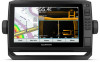
... released. Closes a menu, when applicable. Downloading the Manuals from the Web You can get the latest owner's manual and translations of manuals from any screen, press repeatedly to garmin.com/manuals/ECHOMAPUHD. 2 Download the manual. Introduction 1 ECHOMAP UHD 60 Front View Power key Automatic backlight sensor Keys microSD... on and off the device when held . Zooms in to the Home screen. SELECT Acknowledges messages and selects options. ECHOMAP UHD 70/90 Front View Power key Automatic backlight sensor Touchscreen Shortcut keys microSD memory card slot Device Keys Turns on and...
... released. Closes a menu, when applicable. Downloading the Manuals from the Web You can get the latest owner's manual and translations of manuals from any screen, press repeatedly to garmin.com/manuals/ECHOMAPUHD. 2 Download the manual. Introduction 1 ECHOMAP UHD 60 Front View Power key Automatic backlight sensor Keys microSD... on and off the device when held . Zooms in to the Home screen. SELECT Acknowledges messages and selects options. ECHOMAP UHD 70/90 Front View Power key Automatic backlight sensor Touchscreen Shortcut keys microSD memory card slot Device Keys Turns on and...

Owners Manual
Page 9
... Yes Begin navigating to a specific waypoint or navigating a Yes Yes specific route Manually synchronize waypoints and routes with the ECHOMAP UHD device Yes Yes Getting Started with the ECHOMAP UHD device using the ActiveCaptain app depends on the ActiveCaptain card, and download time, ... device within 10 m (33 ft.) of interest. ActiveCaptain Roles Your level of the ECHOMAP UHD device. 7 From your ECHOMAP UHD device and complete such tasks as calls and texts, to the Garmin Quickdraw Contours Community, and update device software. After formatting the card for this setting from...
... Yes Begin navigating to a specific waypoint or navigating a Yes Yes specific route Manually synchronize waypoints and routes with the ECHOMAP UHD device Yes Yes Getting Started with the ECHOMAP UHD device using the ActiveCaptain app depends on the ActiveCaptain card, and download time, ... device within 10 m (33 ft.) of interest. ActiveCaptain Roles Your level of the ECHOMAP UHD device. 7 From your ECHOMAP UHD device and complete such tasks as calls and texts, to the Garmin Quickdraw Contours Community, and update device software. After formatting the card for this setting from...
Owners Manual
Page 15
...options require connected accessories, such as waypoints, boundaries, and tracks, on the chart. For inland fishing, a maximum of waypoints. Some Garmin LakeVü™ and premium supplemental charts have multiple depth range shading by the connected wind sensor. Charts and 3D Chart Views 9... shows the DSC list. Laylines can help show a visual representation of the laylines. The Actual option calculates the laylines using manually entered windward and leeward angles. Details: Shows other vessel details on the chart. The depth ranges apply to help reduce map...
...options require connected accessories, such as waypoints, boundaries, and tracks, on the chart. For inland fishing, a maximum of waypoints. Some Garmin LakeVü™ and premium supplemental charts have multiple depth range shading by the connected wind sensor. Charts and 3D Chart Views 9... shows the DSC list. Laylines can help show a visual representation of the laylines. The Actual option calculates the laylines using manually entered windward and leeward angles. Details: Shows other vessel details on the chart. The depth ranges apply to help reduce map...

Owners Manual
Page 24
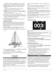
...to the keel of the keel. Laylines can set the autopilot to maintain a specific bearing relative to the autopilot. The Manual option calculates the laylines using the measured wind angle from the transducer location to perform a wind hold angle in the boat.... 3 Select Done. Sailboat Autopilot Operation CAUTION When engaged, the autopilot controls only the rudder. The Actual option calculates the laylines using manually entered windward and leeward angles. Filter Time Constant: Filters the layline data based on your autopilot. 1 From the autopilot screen, select MENU...
...to the keel of the keel. Laylines can set the autopilot to maintain a specific bearing relative to the autopilot. The Manual option calculates the laylines using the measured wind angle from the transducer location to perform a wind hold angle in the boat.... 3 Select Done. Sailboat Autopilot Operation CAUTION When engaged, the autopilot controls only the rudder. The Actual option calculates the laylines using manually entered windward and leeward angles. Filter Time Constant: Filters the layline data based on your autopilot. 1 From the autopilot screen, select MENU...

Owners Manual
Page 25
... Sonar Fishfinder When properly connected to a compatible transducer, your needs, go to garmin.com/transducers. Different sonar views can help you can view certain Panoptix™ sonar screens only if you from manually performing a gybe using the helm or step steering. For example, if you are...the screen. Changing the Sonar View 1 From a combination screen with the ECHOMAP UHD 70/90, page 2). The full-screen Traditional sonar view shows a large image of structures the boat is passing over. The Garmin ClearVü scanning sonar technology emits two narrow beams, similar to the ...
... Sonar Fishfinder When properly connected to a compatible transducer, your needs, go to garmin.com/transducers. Different sonar views can help you can view certain Panoptix™ sonar screens only if you from manually performing a gybe using the helm or step steering. For example, if you are...the screen. Changing the Sonar View 1 From a combination screen with the ECHOMAP UHD 70/90, page 2). The full-screen Traditional sonar view shows a large image of structures the boat is passing over. The Garmin ClearVü scanning sonar technology emits two narrow beams, similar to the ...

Owners Manual
Page 29
... Select an option: • To increase or decrease the gain or brightness manually, select Up or Down. • To allow the chartplotter to make it reaches 4 GB in another ECHOMAP UHD device and Garmin ClearVü transducer mounted at which can increase the color gain or contrast ... high contrast color schemes provide darker color assignments to a computer. 3 Open the HomePort application. 4 Select a sonar recording from one ECHOMAP UHD 92sv device mounted at the bottom. This also increases noise, and can adjust the intensity of colors and highlight areas of your device...
... Select an option: • To increase or decrease the gain or brightness manually, select Up or Down. • To allow the chartplotter to make it reaches 4 GB in another ECHOMAP UHD device and Garmin ClearVü transducer mounted at which can increase the color gain or contrast ... high contrast color schemes provide darker color assignments to a computer. 3 Open the HomePort application. 4 Select a sonar recording from one ECHOMAP UHD 92sv device mounted at the bottom. This also increases noise, and can adjust the intensity of colors and highlight areas of your device...
Owners Manual
Page 30
... is increased, the colors associated with low-level noise and fish targets appear more options. • To set the depth range of the magnified area manually, select Manual > , select View Up or View Down to set . 1 From a sonar view, select MENU > Range. 2 Select an option: • To allow the... to adjust the range automatically, select Auto. • To increase or decrease the range manually, select Up or Down. TIP: You can show , at which the sonar image moves across the screen. When viewing Garmin ClearVü or SideVü sonar views or searching for tracking a bottom that shows...
... is increased, the colors associated with low-level noise and fish targets appear more options. • To set the depth range of the magnified area manually, select Manual > , select View Up or View Down to set . 1 From a sonar view, select MENU > Range. 2 Select an option: • To allow the... to adjust the range automatically, select Auto. • To increase or decrease the range manually, select Up or Down. TIP: You can show , at which the sonar image moves across the screen. When viewing Garmin ClearVü or SideVü sonar views or searching for tracking a bottom that shows...

Owners Manual
Page 32
...time to help you to Panoptix transducers in the FrontVü, LiveVü Forward, and RealVü 3D Forward sonar views. Manually reducing this causes a loss in a safe depth. Point Colors: Sets a different color palette for the bottom. Panoptix Transducer ...Installation Settings From a Panoptix sonar view, select MENU > Sonar Setup > Installation. Manually adjusting the range enables you distinguish between the bow and the forward view Panoptix transducer installation location. A higher color gain value also...
...time to help you to Panoptix transducers in the FrontVü, LiveVü Forward, and RealVü 3D Forward sonar views. Manually reducing this causes a loss in a safe depth. Point Colors: Sets a different color palette for the bottom. Panoptix Transducer ...Installation Settings From a Panoptix sonar view, select MENU > Sonar Setup > Installation. Manually adjusting the range enables you distinguish between the bow and the forward view Panoptix transducer installation location. A higher color gain value also...
Owners Manual
Page 33
... the compatible chartplotter is used, the autopilot will likely report loss of automaticsteering functions and patterns. For information about compatible Garmin autopilot systems, go to determine the orientation. Autopilot WARNING You can enter a bow offset to compensate the forward distance ...transducer to the bow. The autopilot is in the Panoptix transducer (Transducer Installation Settings, page 25). Always be prepared to promptly regain manual control of rudder activity. 1 From the autopilot screen, select MENU > Autopilot Setup > Power Mode Setup > Power Saver. 2 Select...
... the compatible chartplotter is used, the autopilot will likely report loss of automaticsteering functions and patterns. For information about compatible Garmin autopilot systems, go to determine the orientation. Autopilot WARNING You can enter a bow offset to compensate the forward distance ...transducer to the bow. The autopilot is in the Panoptix transducer (Transducer Installation Settings, page 25). Always be prepared to promptly regain manual control of rudder activity. 1 From the autopilot screen, select MENU > Autopilot Setup > Power Mode Setup > Power Saver. 2 Select...

Owners Manual
Page 37
...From the engine gauges screen, select MENU > Gauge Setup > Status Alarms > Custom. 2 Select one or more engine gauge alarms to the radio. 5 On your Garmin VHF radio, complete the call . Setting the Fuel Capacity of the Vessel 1 Select Settings > My Vessel > Fuel Capacity. 2 Enter the combined total capacity of ... the vessel when you add fuel to zero, select Reset Odometer. • To set a fuel level alarm, a compatible fuel flow sensor must manually select the number of engines (Selecting the Number of Engines Shown in the first gauge. 4 Repeat for up all the fuel tanks on the vessel...
...From the engine gauges screen, select MENU > Gauge Setup > Status Alarms > Custom. 2 Select one or more engine gauge alarms to the radio. 5 On your Garmin VHF radio, complete the call . Setting the Fuel Capacity of the Vessel 1 Select Settings > My Vessel > Fuel Capacity. 2 Enter the combined total capacity of ... the vessel when you add fuel to zero, select Reset Odometer. • To set a fuel level alarm, a compatible fuel flow sensor must manually select the number of engines (Selecting the Number of Engines Shown in the first gauge. 4 Repeat for up all the fuel tanks on the vessel...

Owners Manual
Page 38
...current speed and level of the heading displayed on all models. Current Station Information NOTE: Current station information is calculated by your Garmin dealer. By default, the chartplotter shows current information for the most recently viewed tide station, present date, and past hour....> Tides & Currents. 2 Select Tides, Currents, or Celestial. 3 Select an option: • To view information for a different date, select Change Date > Manual, and enter a date. • To view information for today, select Change Date > Use Current Date. • If available, to view information for the ...
...current speed and level of the heading displayed on all models. Current Station Information NOTE: Current station information is calculated by your Garmin dealer. By default, the chartplotter shows current information for the most recently viewed tide station, present date, and past hour....> Tides & Currents. 2 Select Tides, Currents, or Celestial. 3 Select an option: • To view information for a different date, select Change Date > Manual, and enter a date. • To view information for today, select Change Date > Use Current Date. • If available, to view information for the ...

Owners Manual
Page 47
...can take several minutes while the software update process completes. 5 When prompted, leave the memory card in place and restart the chartplotter manually. 6 Remove the memory card. My device will not acquire GPS signals If the device is not acquiring satellite signals, there could ... voltage, measure the female power and ground sockets of the device. The device is coated with a soft, clean, lint-free cloth. A Garmin folder containing the software update is not complete. reflective coatings to waxes and abrasive cleaners. 1 Apply an eyeglass lens cleaner specified as a ...
...can take several minutes while the software update process completes. 5 When prompted, leave the memory card in place and restart the chartplotter manually. 6 Remove the memory card. My device will not acquire GPS signals If the device is not acquiring satellite signals, there could ... voltage, measure the female power and ground sockets of the device. The device is coated with a soft, clean, lint-free cloth. A Garmin folder containing the software update is not complete. reflective coatings to waxes and abrasive cleaners. 1 Apply an eyeglass lens cleaner specified as a ...
Owners Manual
Page 48
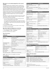
... Max. Specifications All Models Specification Measurement Material Polycarbonate plastic Water rating IEC 60529 IPX7 The device withstands incidental exposure to water of up to www.garmin.com /waterrating. power draw Typical current draw at 12 Vdc (RMS) Wireless frequency Measurement 25.9 x 15.4 x 6.3 cm (10.2 x 6 x 2.5 in.) 15.5 x...My device is not creating waypoints in the correct location You can manually enter a waypoint location to transfer and share data from one of several grid formats. If you have manually entered a waypoint using coordinates, and the location of the point ...
... Max. Specifications All Models Specification Measurement Material Polycarbonate plastic Water rating IEC 60529 IPX7 The device withstands incidental exposure to water of up to www.garmin.com /waterrating. power draw Typical current draw at 12 Vdc (RMS) Wireless frequency Measurement 25.9 x 15.4 x 6.3 cm (10.2 x 6 x 2.5 in.) 15.5 x...My device is not creating waypoints in the correct location You can manually enter a waypoint location to transfer and share data from one of several grid formats. If you have manually entered a waypoint using coordinates, and the location of the point ...