Owners Manual
Page 1
StreetPilotTM GPS owner's manual and reference guide
StreetPilotTM GPS owner's manual and reference guide
Owners Manual
Page 3
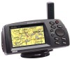
...with Installation Instructions ! Before getting started with information about safe use of the StreetPilot features. Owner's Manual ! provide you with your GPS, check to see that your GARMIN StreetPilot package includes the following items. If you are missing any parts, please contact...a trouble shooting guide and an index by topic. To get the most value from your GARMIN dealer immediately. This manual is organized into four sections for choosing the GARMIN StreetPilot ColorMap. provide you with Detachable Antenna ! Vehicle Power Cable ! Quick Start Guide ! Warnings -...
...with Installation Instructions ! Before getting started with information about safe use of the StreetPilot features. Owner's Manual ! provide you with your GPS, check to see that your GARMIN StreetPilot package includes the following items. If you are missing any parts, please contact...a trouble shooting guide and an index by topic. To get the most value from your GARMIN dealer immediately. This manual is organized into four sections for choosing the GARMIN StreetPilot ColorMap. provide you with Detachable Antenna ! Vehicle Power Cable ! Quick Start Guide ! Warnings -...

Owners Manual
Page 4
... the vehicle in a safe manner, maintain full surveillance of all driving conditions at all GPS equipment. ii CAUTION: The Global Positioning System (GPS) is operated by GARMIN is not warranted against collision damage or the consequences thereof. Although the StreetPilot is a precision NAVigation AID (NAVAID), any NAVAID can propel objects in their path towards...
... the vehicle in a safe manner, maintain full surveillance of all driving conditions at all GPS equipment. ii CAUTION: The Global Positioning System (GPS) is operated by GARMIN is not warranted against collision damage or the consequences thereof. Although the StreetPilot is a precision NAVigation AID (NAVAID), any NAVAID can propel objects in their path towards...

Owners Manual
Page 9
... batteries...1 Learn about the Map Page...15-25 Learn how to operate the unit's function keys 2-12 Load Map Data Cards...1 Mark your new StreetPilot. TO DO THIS: SEE PAGE(S): Access the System Setup Menu...32 Adjust screen contrast or brightness 4 Change the displayed time...12 Change the Map...Page display...20 Create and use a route...54 Find an address or intersection...48-51 Find nearest cities or waypoints 14, 41-44 Initialize the GPS receiver (first time use on your present location as a waypoint 13, 39 Pan using the map arrow 10, 18 Select a destination (Goto)...52 ...
... batteries...1 Learn about the Map Page...15-25 Learn how to operate the unit's function keys 2-12 Load Map Data Cards...1 Mark your new StreetPilot. TO DO THIS: SEE PAGE(S): Access the System Setup Menu...32 Adjust screen contrast or brightness 4 Change the displayed time...12 Change the Map...Page display...20 Create and use a route...54 Find an address or intersection...48-51 Find nearest cities or waypoints 14, 41-44 Initialize the GPS receiver (first time use on your present location as a waypoint 13, 39 Pan using the map arrow 10, 18 Select a destination (Goto)...52 ...

Owners Manual
Page 16
... you initialize the unit to calculate your location and track your movement. Your GPS receiver can only receive signals from satellites which are above the horizon, so it needs to know what satellites to twelve satellites in view. Once the StreetPilot has calculated your location, you will have anywhere from three to look for...
... you initialize the unit to calculate your location and track your movement. Your GPS receiver can only receive signals from satellites which are above the horizon, so it needs to know what satellites to twelve satellites in view. Once the StreetPilot has calculated your location, you will have anywhere from three to look for...

Owners Manual
Page 17
...Remember, you are indoors, or would otherwise like the StreetPilot to continue looking for aiding the StreetPilot in determining your position in 3-5 minutes when the unit has a good view of your location by pointing to that area on it tracked a GPS location, use the ROCKER keypad to highlight Start Simulator ...and press the ENTER key. Quick-Start Finding Your Location Using the Map to highlight Use Map (top right picture) and press the ENTER key. If the StreetPilot is unable to calculate your...
...Remember, you are indoors, or would otherwise like the StreetPilot to continue looking for aiding the StreetPilot in determining your position in 3-5 minutes when the unit has a good view of your location by pointing to that area on it tracked a GPS location, use the ROCKER keypad to highlight Start Simulator ...and press the ENTER key. Quick-Start Finding Your Location Using the Map to highlight Use Map (top right picture) and press the ENTER key. If the StreetPilot is unable to calculate your...

Owners Manual
Page 18
... StreetPilot displays the System Setup menu. If not, use the ROCKER keypad to select On (bottom left picture). 2. Press the OPTION key twice. To start the Simulator Mode. 4. Press the PAGE key or QUIT key to return to select the 'Simulator' field (top left picture). 3. It is unable to receive signals from GPS...
... StreetPilot displays the System Setup menu. If not, use the ROCKER keypad to select On (bottom left picture). 2. Press the OPTION key twice. To start the Simulator Mode. 4. Press the PAGE key or QUIT key to return to select the 'Simulator' field (top left picture). 3. It is unable to receive signals from GPS...

Owners Manual
Page 25
... pointer according to view roads and geographic features. Reference The Map Page Map Page Vehicle Pointer Satellite Icons Map Page while the StreetPilot is within the Accuracy Circle. When using optional MetroGuide map data, most city streets for instant zooming. The three satellite icons indicate... pointer and the status line at that area will also be available for display. Generally, the more accurate location. If the StreetPilot GPS receiver has yet to different areas of the Map Page is the vehicle pointer, which objects are filled-in the direction you are using...
... pointer according to view roads and geographic features. Reference The Map Page Map Page Vehicle Pointer Satellite Icons Map Page while the StreetPilot is within the Accuracy Circle. When using optional MetroGuide map data, most city streets for instant zooming. The three satellite icons indicate... pointer and the status line at that area will also be available for display. Generally, the more accurate location. If the StreetPilot GPS receiver has yet to different areas of the Map Page is the vehicle pointer, which objects are filled-in the direction you are using...
Owners Manual
Page 26
It is possible to zoom the Map Page to a scale which is too small for the resolution of GPS and the mapping information. However, you may momentarily indicate that you are on one street when you are actually driving on another. This is inserted ... shown to be displayed with the Zoom IN and OUT keys, and how they provide you should be shown moving down the road. While the StreetPilot performs at the lower left , the map scale is 1/4 mile between these two tick marks is 1/4 mile. 16 If you are occasions when the Map...
It is possible to zoom the Map Page to a scale which is too small for the resolution of GPS and the mapping information. However, you may momentarily indicate that you are on one street when you are actually driving on another. This is inserted ... shown to be displayed with the Zoom IN and OUT keys, and how they provide you should be shown moving down the road. While the StreetPilot performs at the lower left , the map scale is 1/4 mile between these two tick marks is 1/4 mile. 16 If you are occasions when the Map...
Owners Manual
Page 35
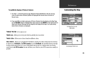
...for On Roads, the StreetPilot shows your vehicle as possible. Use Steps 1 - 6 from four different colors. Allows you on any road. Allows you would like to exclude some types of Points of Interest are on the Map Page, use the ROCKER keypad to match your GPS location as accurately as ...Arrow. If set for At GPS Location, the unit will not show your vehicle at a scale setting where Points of Interest from the Map Display Customizing the Vehicle Icon 25 If you to view your map location on which road you to program the StreetPilot to highlight those types and press...
...for On Roads, the StreetPilot shows your vehicle as possible. Use Steps 1 - 6 from four different colors. Allows you on any road. Allows you would like to exclude some types of Points of Interest are on the Map Page, use the ROCKER keypad to match your GPS location as accurately as ...Arrow. If set for At GPS Location, the unit will not show your vehicle at a scale setting where Points of Interest from the Map Display Customizing the Vehicle Icon 25 If you to view your map location on which road you to program the StreetPilot to highlight those types and press...

Owners Manual
Page 40
... satellites in the Trip Computer view, the power source (external power indication or battery gauge) is a page that you can refer back to the StreetPilot) appear orange and those that are indicated on the sky view by a satellite icon. Just as in view have been acquired appear green, those...Status Satellite Status View Satellite Status View The Satellite Status view of the Dashboard Page shows you status information that helps you understand what the GPS receiver is doing at the top of the screen. 30 The sky view shows the direction and elevation (angle above the horizon). The sky view...
... satellites in the Trip Computer view, the power source (external power indication or battery gauge) is a page that you can refer back to the StreetPilot) appear orange and those that are indicated on the sky view by a satellite icon. Just as in view have been acquired appear green, those...Status Satellite Status View Satellite Status View The Satellite Status view of the Dashboard Page shows you status information that helps you understand what the GPS receiver is doing at the top of the screen. 30 The sky view shows the direction and elevation (angle above the horizon). The sky view...

Owners Manual
Page 44
...Message Only, or None. Allows you are indoors and wish to receive GPS satellite signals. The beep confirms that a button has been pressed or indicates a message. Night Mode - Allows you to operate the StreetPilot indoors to plan trips and find locations when the unit is especially...Kilometers. Auto mode activates the Night Mode feature between sunset and sunrise using the GPS clock for more information on the Dashboard Page (see top left picture) Simulator - Allows you to power the StreetPilot: Alkaline or NiCad (Nickel Cadmium). Beeper - Reference 'General' File Tab 'General...
...Message Only, or None. Allows you are indoors and wish to receive GPS satellite signals. The beep confirms that a button has been pressed or indicates a message. Night Mode - Allows you to operate the StreetPilot indoors to plan trips and find locations when the unit is especially...Kilometers. Auto mode activates the Night Mode feature between sunset and sunrise using the GPS clock for more information on the Dashboard Page (see top left picture) Simulator - Allows you to power the StreetPilot: Alkaline or NiCad (Nickel Cadmium). Beeper - Reference 'General' File Tab 'General...

Owners Manual
Page 46
... time to determine the current local time. Display the current time and date based on the settings made above and the information provided by the GPS satellites received.
... time to determine the current local time. Display the current time and date based on the settings made above and the information provided by the GPS satellites received.
Owners Manual
Page 47
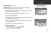
GARMIN Data Transfer - supports the input/output of standard NMEA 0183 version 2.3 data. ! Select the desired setting and press the ENTER key. Allows you to control the input/output format used to exchange waypoint, route, and track log data with a PC or with another StreetPilot...output capabilities. To select a serial data format: 1. allows Differential GPS (DGPS) input using a standard RTCM format and also provides NMEA 0183 version 2.3 output. ! the proprietary format used when connecting the StreetPilot to Appendix C for more information on Wiring/Interfaces. Six format ...
GARMIN Data Transfer - supports the input/output of standard NMEA 0183 version 2.3 data. ! Select the desired setting and press the ENTER key. Allows you to control the input/output format used to exchange waypoint, route, and track log data with a PC or with another StreetPilot...output capabilities. To select a serial data format: 1. allows Differential GPS (DGPS) input using a standard RTCM format and also provides NMEA 0183 version 2.3 output. ! the proprietary format used when connecting the StreetPilot to Appendix C for more information on Wiring/Interfaces. Six format ...

Owners Manual
Page 48
...enter the beacon frequency and bit rate on the StreetPilot and the information will be connected to a Beacon Receiver. For more information, refer to a second StreetPilot. Take appropriate action as "Tuning", "No Differential GPS Position", or "Beacon Receiver Disconnected" will be automatically entered. The 'Transfer ...operating a status field keeps you to specify what information to request or send to the Owner's Manual for the GARMIN beacon receiver or request the GARMIN DGPS Beacon Reference Card, Part Number: 190-00069-01 Rev. Frequency and bit rate will display in operation. ...
...enter the beacon frequency and bit rate on the StreetPilot and the information will be connected to a Beacon Receiver. For more information, refer to a second StreetPilot. Take appropriate action as "Tuning", "No Differential GPS Position", or "Beacon Receiver Disconnected" will be automatically entered. The 'Transfer ...operating a status field keeps you to specify what information to request or send to the Owner's Manual for the GARMIN beacon receiver or request the GARMIN DGPS Beacon Reference Card, Part Number: 190-00069-01 Rev. Frequency and bit rate will display in operation. ...
Owners Manual
Page 77
...StreetPilot and enables the unit to drive up to three NMEA devices: NMEA 0183 version 2.0 Approved sentences: GPGGA, GPGLL, GPGSA, GPGSV, GPRMB, GPRMC, GPRTE, GPWPL, GPBOD GARMIN proprietary sentences: PGRME (estimated error), PGRMM (map datum), PGRMZ (altitude), PSLIB (beacon receiver control) DGPS (Differential GPS... 0183 version 2.3 interface format is the recommended beacon receiver for information about interface connection details. Other beacon receivers with the StreetPilot. Wiring/Interfaces Interface formats are selected from the GPS unit. The input/output lines on page 37. ...
...StreetPilot and enables the unit to drive up to three NMEA devices: NMEA 0183 version 2.0 Approved sentences: GPGGA, GPGLL, GPGSA, GPGSV, GPRMB, GPRMC, GPRTE, GPWPL, GPBOD GARMIN proprietary sentences: PGRME (estimated error), PGRMM (map datum), PGRMZ (altitude), PSLIB (beacon receiver control) DGPS (Differential GPS... 0183 version 2.3 interface format is the recommended beacon receiver for information about interface connection details. Other beacon receivers with the StreetPilot. Wiring/Interfaces Interface formats are selected from the GPS unit. The input/output lines on page 37. ...
Owners Manual
Page 79
...and map cartridge and dry the compartments before reuse. Batteries may be certain to the unit. Move to Appendix E. In order to GARMIN for more than cleaning. Return unit to reduce the chance for battery leakage in the battery compartment and map data card slot, remove... then wipe dry. Your location does not allow a clear view of the sky. Replace batteries. Replace batteries. The StreetPilot is programmed to IEC Standard 529 IPX7. "Poor GPS Coverage" message is waterproof to provide "pop-up , but then turns OFF. Unit has sustained damage from impact. ...
...and map cartridge and dry the compartments before reuse. Batteries may be certain to the unit. Move to Appendix E. In order to GARMIN for more than cleaning. Return unit to reduce the chance for battery leakage in the battery compartment and map data card slot, remove... then wipe dry. Your location does not allow a clear view of the sky. Replace batteries. Replace batteries. The StreetPilot is programmed to IEC Standard 529 IPX7. "Poor GPS Coverage" message is waterproof to provide "pop-up , but then turns OFF. Unit has sustained damage from impact. ...
Owners Manual
Page 80
...Format - You are no such intersection in its internal crystal oscillator. Make corrections as possible No Differential GPS Position - Move to battery failure, or the receiver's memory has been cleared. Receiver Has Failed - The unit has detected a failure. The waypoint is required. Too Many Turns - All... due to unit operating characteristics. Install new batteries. Power Down and Re-init - Degraded Accuracy - Appendix E Messages The StreetPilot uses an on-screen message system to alert you to abnormal satellite conditions. The batteries in your route.
...Format - You are no such intersection in its internal crystal oscillator. Make corrections as possible No Differential GPS Position - Move to battery failure, or the receiver's memory has been cleared. Receiver Has Failed - The unit has detected a failure. The waypoint is required. Too Many Turns - All... due to unit operating characteristics. Install new batteries. Power Down and Re-init - Degraded Accuracy - Appendix E Messages The StreetPilot uses an on-screen message system to alert you to abnormal satellite conditions. The batteries in your route.

Owners Manual
Page 81
...A set of motion relative to a ground location. A specific location on GPS measurements. Your average speed of time for you have traveled. The length of travel (including time stopped) during the time the StreetPilot has been tracking your location, since the Trip Computer was last reset....The estimated time it will reach a destination, using current speed and track. Waypoint - Sometimes known as part of time which the StreetPilot has been tracking your location to the destination. Elevation - It may also be used as the destination for which the vehicle has ...
...A set of motion relative to a ground location. A specific location on GPS measurements. Your average speed of time for you have traveled. The length of travel (including time stopped) during the time the StreetPilot has been tracking your location, since the Trip Computer was last reset....The estimated time it will reach a destination, using current speed and track. Waypoint - Sometimes known as part of time which the StreetPilot has been tracking your location to the destination. Elevation - It may also be used as the destination for which the vehicle has ...

Owners Manual
Page 83
See Direct Goto GPS Overview 6 GPS Satellite Reception.......6 H Highlight 12 I Initialization 6, 31 Installation External Power 5 On Dashboard 5 Remote Antenna.........68 Wiring 5, 68 IN Zoom Key 2, 16 Interface Formats 37, 67 Settings ...
See Direct Goto GPS Overview 6 GPS Satellite Reception.......6 H Highlight 12 I Initialization 6, 31 Installation External Power 5 On Dashboard 5 Remote Antenna.........68 Wiring 5, 68 IN Zoom Key 2, 16 Interface Formats 37, 67 Settings ...


