Owners Manual
Page 3
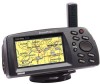
... the StreetPilot's operating features. Additional Information - The Appendices section contains information on items such as accessories, specifications, a trouble shooting guide and an index by topic. Quick Start Guide ! Notes - provides you with easy methods of the StreetPilot. Standard Package: ! Owner's Manual ! StreetPilot ColorMap Unit with Installation Instructions ! Dash Mount Kit with Detachable Antenna ! i This manual is organized into four sections for your new GPS, please take time to read through this owner's manual in a versatile and user-friendly...
... the StreetPilot's operating features. Additional Information - The Appendices section contains information on items such as accessories, specifications, a trouble shooting guide and an index by topic. Quick Start Guide ! Notes - provides you with easy methods of the StreetPilot. Standard Package: ! Owner's Manual ! StreetPilot ColorMap Unit with Installation Instructions ! Dash Mount Kit with Detachable Antenna ! i This manual is organized into four sections for your new GPS, please take time to read through this owner's manual in a versatile and user-friendly...

Owners Manual
Page 6
... used in a particular installation. Unauthorized repairs or modifications could void your warranty and your authority to operate this device does cause harmful interference to other equipment or reorienting or relocating the receiving antenna. Repairs should only be determined by an authorized GARMIN service center. If this device under Part 15 regulations. Introduction FCC Compliance iv The GARMIN StreetPilot has been tested to comply with instructions...
... used in a particular installation. Unauthorized repairs or modifications could void your warranty and your authority to operate this device does cause harmful interference to other equipment or reorienting or relocating the receiving antenna. Repairs should only be determined by an authorized GARMIN service center. If this device under Part 15 regulations. Introduction FCC Compliance iv The GARMIN StreetPilot has been tested to comply with instructions...
Owners Manual
Page 8
... QUICK-START Battery/Card Installation 1 Keypad Usage 2 Turning the Unit On and Off 3 Screen Brightness/Contrast 4 Dash Mounting and External Power....5 Finding Your Location 6 Using the Simulator 8 Main Page Sequence 9 Map Zooming and Panning 10 Trip Computer Option Key 11 Making Keypad Entries 12 Using Find and Goto 14 vi Section Three - Introduction Table of Interest......46 Finding an Address 48 Finding an Intersection..........51 Navigating on a Direct Goto....52 Routes 54 Creating a Route 54 Editing...
... QUICK-START Battery/Card Installation 1 Keypad Usage 2 Turning the Unit On and Off 3 Screen Brightness/Contrast 4 Dash Mounting and External Power....5 Finding Your Location 6 Using the Simulator 8 Main Page Sequence 9 Map Zooming and Panning 10 Trip Computer Option Key 11 Making Keypad Entries 12 Using Find and Goto 14 vi Section Three - Introduction Table of Interest......46 Finding an Address 48 Finding an Intersection..........51 Navigating on a Direct Goto....52 Routes 54 Creating a Route 54 Editing...

Owners Manual
Page 9
... System Setup Menu...32 Adjust screen contrast or brightness 4 Change the displayed time...12 Change the Map Page display...20 Create and use a route...54 Find an address or intersection...48-51 Find nearest cities or waypoints 14, 41-44 Initialize the GPS receiver (first time use)...6 Install batteries...1 Learn about the Map Page...15-25 Learn how to help you quickly find some of the more important procedures you will use on your present location...
... System Setup Menu...32 Adjust screen contrast or brightness 4 Change the displayed time...12 Change the Map Page display...20 Create and use a route...54 Find an address or intersection...48-51 Find nearest cities or waypoints 14, 41-44 Initialize the GPS receiver (first time use)...6 Install batteries...1 Learn about the Map Page...15-25 Learn how to help you quickly find some of the more important procedures you will use on your present location...
Owners Manual
Page 11
... be downloaded to the battery compartment, with used . Caution Make certain the connector end of backlighting. SECTION 2 Quick-Start Battery/Map Data Card Installation The StreetPilot operates on -screen battery level indicator may be calibrated for Card and MapSource ordering information. The on six (6) AA batteries, which are installed from GARMIN. Do not mix Alkaline with the MapSource CD-ROM. Close the battery compartment door and lock in colder conditions. Battery/Map Card Installation Compartment Door Map Data Card AA Batteries...
... be downloaded to the battery compartment, with used . Caution Make certain the connector end of backlighting. SECTION 2 Quick-Start Battery/Map Data Card Installation The StreetPilot operates on -screen battery level indicator may be calibrated for Card and MapSource ordering information. The on six (6) AA batteries, which are installed from GARMIN. Do not mix Alkaline with the MapSource CD-ROM. Close the battery compartment door and lock in colder conditions. Battery/Map Card Installation Compartment Door Map Data Card AA Batteries...

Owners Manual
Page 12
... the selected value(s). When entering data, it as a destination. It also marks the location of cursor on the Map Page. Press twice to turn the StreetPilot off . The OPTION Key Displays a menu of Interest, Addresses, or Intersections. Press and hold to display System Setup options. When entering data, restores the previous value (cancels data entry). The ROCKER Keypad Used to start or stop navigating a route. Allows listed items to be viewed on a map or selected...
... the selected value(s). When entering data, it as a destination. It also marks the location of cursor on the Map Page. Press twice to turn the StreetPilot off . The OPTION Key Displays a menu of Interest, Addresses, or Intersections. Press and hold to display System Setup options. When entering data, restores the previous value (cancels data entry). The ROCKER Keypad Used to start or stop navigating a route. Allows listed items to be viewed on a map or selected...

Owners Manual
Page 15
... installation of a mounting bracket, mounting base, required hardware and adhesive pads is included in the instruction sheet provided with vehicle operation in any way. Mate the plug on the StreetPilot as explained in the StreetPilot package. This provides a semi-permanent method of the StreetPilot unit (behind the rubber weather cap). General instructions are included here for the driver or passenger(s). Quick-Start Dash Mounting and External Power Connection...
... installation of a mounting bracket, mounting base, required hardware and adhesive pads is included in the instruction sheet provided with vehicle operation in any way. Mate the plug on the StreetPilot as explained in the StreetPilot package. This provides a semi-permanent method of the StreetPilot unit (behind the rubber weather cap). General instructions are included here for the driver or passenger(s). Quick-Start Dash Mounting and External Power Connection...

Owners Manual
Page 16
... first time you use your StreetPilot to navigate, take it outside or properly mount it . ! Your GPS receiver can only receive signals from the factory). ! Quick-Start Finding Your Location 6 Finding Your Location The first time you use your StreetPilot (new from satellites which does not require reception of using a Simulator Mode which are above the horizon, so it will typically compute a position within five (5) minutes after being turned on with the power off...
... first time you use your StreetPilot to navigate, take it outside or properly mount it . ! Your GPS receiver can only receive signals from the factory). ! Quick-Start Finding Your Location 6 Finding Your Location The first time you use your StreetPilot (new from satellites which does not require reception of using a Simulator Mode which are above the horizon, so it will typically compute a position within five (5) minutes after being turned on with the power off...

Owners Manual
Page 22
... street addresses, points of the ROCKER keypad to select. Selecting from eight U.S. Use the LEFT or RIGHT area of interest, and city names to select the System Setup Page. 2. Use the UP, DOWN, LEFT, and RIGHT areas of these operations can be adjusted for finding and entering information. Use UP and DOWN to enter the offset numbers, then LEFT and RIGHT to move to select the appropriate time...
... street addresses, points of the ROCKER keypad to select. Selecting from eight U.S. Use the LEFT or RIGHT area of interest, and city names to select the System Setup Page. 2. Use the UP, DOWN, LEFT, and RIGHT areas of these operations can be adjusted for finding and entering information. Use UP and DOWN to enter the offset numbers, then LEFT and RIGHT to move to select the appropriate time...

Owners Manual
Page 25
... to view roads and geographic features. The StreetPilot has a very high certainty that your location is finding your location. If you are shown with the 'Customize Map' option (see page 22). Nearby Personal Waypoints are using the 'Track up" option, the map automatically rotates as you make turns, keeping the current direction of travel at the top of the page screen displays, 'Acquiring Satellites'. This screen shows the vehicle...
... to view roads and geographic features. The StreetPilot has a very high certainty that your location is finding your location. If you are shown with the 'Customize Map' option (see page 22). Nearby Personal Waypoints are using the 'Track up" option, the map automatically rotates as you make turns, keeping the current direction of travel at the top of the page screen displays, 'Acquiring Satellites'. This screen shows the vehicle...

Owners Manual
Page 30
... key to create a Personal Waypoint on the Map Page. 2. To enable a larger map display, select Show Map Full Screen, which removes the Driving Status and other information again. Allows you to display the driving status and other information that select what is displayed on the Map Page, as well as how it (top left picture) and are shown on the screen. Select this option to set a variety of...
... key to create a Personal Waypoint on the Map Page. 2. To enable a larger map display, select Show Map Full Screen, which removes the Driving Status and other information again. Allows you to display the driving status and other information that select what is displayed on the Map Page, as well as how it (top left picture) and are shown on the screen. Select this option to set a variety of...

Owners Manual
Page 40
... direction and elevation (angle above the horizon). Reference Satellite Status Satellite Status View Satellite Status View The Satellite Status view of the Dashboard Page shows you status information that helps you understand what the GPS receiver is doing at the top of the screen. 30 It features a sky view of available satellites, corresponding signal strength bar graphs, and your vehicle. Just as in the Trip Computer view, the power source (external power indication or battery...
... direction and elevation (angle above the horizon). Reference Satellite Status Satellite Status View Satellite Status View The Satellite Status view of the Dashboard Page shows you status information that helps you understand what the GPS receiver is doing at the top of the screen. 30 It features a sky view of available satellites, corresponding signal strength bar graphs, and your vehicle. Just as in the Trip Computer view, the power source (external power indication or battery...

Owners Manual
Page 57
... displayed by pressing the 'Information' button displayed when in the map mode. Use the ROCKER keypad to scroll through the list and make a selection then press the ENTER key to display the list of interest will be changed to display the address, city, and telephone number by "Nearest" or "By Name" 4. 3. List of Point of the page. Pressing the ENTER key with Navigation Directions and Distance 47 The list will be displayed on the programming mode...
... displayed by pressing the 'Information' button displayed when in the map mode. Use the ROCKER keypad to scroll through the list and make a selection then press the ENTER key to display the list of interest will be changed to display the address, city, and telephone number by "Nearest" or "By Name" 4. 3. List of Point of the page. Pressing the ENTER key with Navigation Directions and Distance 47 The list will be displayed on the programming mode...

Owners Manual
Page 64
... the route. To demonstrate a route, plan a trip from San Francisco Airport to view the Route menu. 2. Press the ROUTE key to historic Alcatraz Island. Highlight Create New Route (top left picture). Remember you can select your starting point and your destination and then manually select a route by -turn directions when a destination is shown in the lower right corner of Interest, Address or Intersection to use the Zoom IN and OUT keys to quickly...
... the route. To demonstrate a route, plan a trip from San Francisco Airport to view the Route menu. 2. Press the ROUTE key to historic Alcatraz Island. Highlight Create New Route (top left picture). Remember you can select your starting point and your destination and then manually select a route by -turn directions when a destination is shown in the lower right corner of Interest, Address or Intersection to use the Zoom IN and OUT keys to quickly...

Owners Manual
Page 74
... certain types of maps in greater numbers. Uses data transfer cable provided with Blank 8 MB Data Card Part Number: 010-10215-13 ! Accessories offered for sale by the StreetPilot is a collection of coverage or use with GARMIN products. Topographic, and 3. Appendix A Accessories MapSource® CD's MapSource* CD-ROM Map Databases: ! MetroGuide U.S.A. MetroGuide, 2. United States Topo Part Number: 010-10215-02 ! with the StreetPilot. The type of map being displayed will fill an 8 MB Data Card...
... certain types of maps in greater numbers. Uses data transfer cable provided with Blank 8 MB Data Card Part Number: 010-10215-13 ! Accessories offered for sale by the StreetPilot is a collection of coverage or use with GARMIN products. Topographic, and 3. Appendix A Accessories MapSource® CD's MapSource* CD-ROM Map Databases: ! MetroGuide U.S.A. MetroGuide, 2. United States Topo Part Number: 010-10215-02 ! with the StreetPilot. The type of map being displayed will fill an 8 MB Data Card...
Owners Manual
Page 79
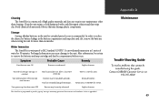
... dry. The StreetPilot is programmed to reduce the chance for battery leakage in the battery compartment and map data card slot, remove the batteries when storing the unit for 30 minutes. Batteries may be certain to a new location. Replace batteries. Symptom Probable Cause Remedy Unit does not turn ON Batteries are exhausted. Unit has sustained damage from impact. Batteries may be remedied using a cloth dampened with new batteries. Clean the unit using this guide, Contact GARMIN Customer Service at 913...
... dry. The StreetPilot is programmed to reduce the chance for battery leakage in the battery compartment and map data card slot, remove the batteries when storing the unit for 30 minutes. Batteries may be certain to a new location. Replace batteries. Symptom Probable Cause Remedy Unit does not turn ON Batteries are exhausted. Unit has sustained damage from impact. Batteries may be remedied using a cloth dampened with new batteries. Clean the unit using this guide, Contact GARMIN Customer Service at 913...
Owners Manual
Page 80
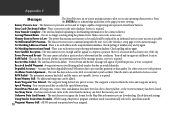
... and the unit is an error in the map information database. Stored Data Was Lost - While using a MapSource program, simulator mode is no such intersection in the unit's database. There is not operable. Service is removed from the route and waypoint memory. Data Transfer Complete - The unit has finished uploading or downloading information to abnormal satellite conditions. Poor Satellite Reception - The unit cannot calculate a position due to the connected device. The unit has detected a failure. "Power Down...
... and the unit is an error in the map information database. Stored Data Was Lost - While using a MapSource program, simulator mode is no such intersection in the unit's database. There is not operable. Service is removed from the route and waypoint memory. Data Transfer Complete - The unit has finished uploading or downloading information to abnormal satellite conditions. Poor Satellite Reception - The unit cannot calculate a position due to the connected device. The unit has detected a failure. "Power Down...

Owners Manual
Page 83
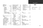
..., 71 Direction to Turn 60 Distance Units 34 Driving On a Direct Goto..........52 On a Route 60 F Factory Settings, Restoring 33 Features viii File Tabs 33 FIND Key 2 Finding Locations.........14, 39 Addresses 48 Cities 41 Intersections 51 Personal Waypoints.......44 Points of Interest...........46 Food and Drink, Finding....46 Index G Goto - See Direct Goto GPS Overview 6 GPS Satellite Reception.......6 H Highlight 12 I Initialization 6, 31 Installation External Power 5 On Dashboard 5 Remote Antenna.........68...
..., 71 Direction to Turn 60 Distance Units 34 Driving On a Direct Goto..........52 On a Route 60 F Factory Settings, Restoring 33 Features viii File Tabs 33 FIND Key 2 Finding Locations.........14, 39 Addresses 48 Cities 41 Intersections 51 Personal Waypoints.......44 Points of Interest...........46 Food and Drink, Finding....46 Index G Goto - See Direct Goto GPS Overview 6 GPS Satellite Reception.......6 H Highlight 12 I Initialization 6, 31 Installation External Power 5 On Dashboard 5 Remote Antenna.........68...

Owners Manual
Page 84
... Keypad 2 L Latitude/Longitude...........23 Lodging, Finding 46 M Main Page Sequence...........9 Map Auto Zoom 22 Customizing 22 Detail 22 Measuring Distances ...21 Orientation 22 Panning 10, 18 Scale 10, 16 Showing Full Screen...20 74 Map Data Cards 16 Installing 1 Map Page............9, 10, 15-25 Options 21 MENU Key 21 Maximum Speed.........28, 71 Resetting 29 Measuring Distances.........21 Messages 70 Mounting 5 N Navigation Info 17 Starting 53 Stopping...
... Keypad 2 L Latitude/Longitude...........23 Lodging, Finding 46 M Main Page Sequence...........9 Map Auto Zoom 22 Customizing 22 Detail 22 Measuring Distances ...21 Orientation 22 Panning 10, 18 Scale 10, 16 Showing Full Screen...20 74 Map Data Cards 16 Installing 1 Map Page............9, 10, 15-25 Options 21 MENU Key 21 Maximum Speed.........28, 71 Resetting 29 Measuring Distances.........21 Messages 70 Mounting 5 N Navigation Info 17 Starting 53 Stopping...
Owners Manual
Page 85
..., 60 Routes 54-62 Copying 59 Creating 54 Deleting 58 Driving On 60 Editing 56 List 58, 59 Naming 56 Starting Navigation......58 Stopping Navigation 21, 53, 58 S Satellite Status View.....26, 30 Screen Contrast 4 Night Mode 34 Selecting Categories..........46 Services, Finding 46 Setup Options 32 Shopping, Finding...........46 Show Vehicle 25 Simulator Mode............8, 34 Specifications 65-66 Speed 17, 27, 71 Speed Alarm 35 Standard Accessories........63 Starting Navigation...........58 Street Names...
..., 60 Routes 54-62 Copying 59 Creating 54 Deleting 58 Driving On 60 Editing 56 List 58, 59 Naming 56 Starting Navigation......58 Stopping Navigation 21, 53, 58 S Satellite Status View.....26, 30 Screen Contrast 4 Night Mode 34 Selecting Categories..........46 Services, Finding 46 Setup Options 32 Shopping, Finding...........46 Show Vehicle 25 Simulator Mode............8, 34 Specifications 65-66 Speed 17, 27, 71 Speed Alarm 35 Standard Accessories........63 Starting Navigation...........58 Street Names...


