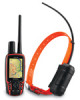
Garmin Astro 320 Support Question
Garmin Astro 320 Support Question
Find answers below for this question about Garmin Astro 320.Need a Garmin Astro 320 manual? We have 6 online manuals for this item!
Question posted by johnlindastrick on May 14th, 2013
Map Clutter
My Astro 320's map has these triangle shaped symbols on it with an arrow pointing up or down by each one. There ar really thick lines going from one to another.
How do I get rid of them?
Current Answers
Related Garmin Astro 320 Manual Pages
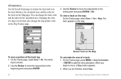
Quick Start Manual - Page 1
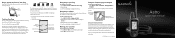
....
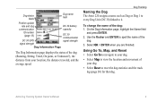
Dog Status Icons
Sitting Running On point Treed Unknown
The Unknown status symbol [?], indicates that the DC 30 has not acquired a satellite signal and that direction until the pointer is shortened. Use the compass page to navigate to the point.
To find the location on the Astro and then use the compass to navigate...
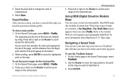
Quick Start Manual - Page 2
..., when you to adjust your turning speed. Press the Rocker up arrow or down arrow to an
appropriate electrical source.
2.
Go outdoors to link the additional DC 30 with the Astro 220. Acquiring GPS satellite signals can find your Astro 220 system was packaged with the Astro 220 at a steady pulse. Hold the unit level and turn...
Astro and DC 30 Owner's Manual - Page 4
...the Batteries in the Astro 220 2 Using the Astro 220 Keypad Functions 3 Turning the Astro 220 On 4 Charging the DC 30 4 Acquiring GPS Satellite Signals 5 Calibrating the Astro 220 Compass 6 Operating the Astro 220 6 Manual ...Item Information Page Options 22 Using Optional Detailed Maps 22 POI Loader and Custom Points of Interest 23
GPS Applications 24 Using the Trip Computer 24 Using...
Astro and DC 30 Owner's Manual - Page 15
...Astro 220 assigns a name such as Dog or Dog 1 to every Dog Unit (DC 30) linked to spell the name of the
dog. 3.
Use the Rocker and ENTER to it. On the Dog Information page, highlight the Name field
and press ENTER. 2. Using Go To, Map...GPS
signal strength
signal strength
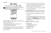
Dog Information Page
The Dog Information page displays the status of the dog (Running, Sitting, Treed, On point,...
Astro and DC 30 Owner's Manual - Page 20
...8226; Find (page 20) • GPS Applications (page 24) • Accessories (page 41) • Settings (page 44)
Astro Dog Tracking System Owner's Manual Go To Marked Location-provides directions to open ...rise and set times for a different location, select the Location field > Use Map and select a point using the Rocker.
View Hunting Almanac-provides predicted best times for hunting and ...
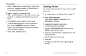
Astro and DC 30 Owner's Manual - Page 28
...> Find >
Addresses (or Intersections). If your unit has a GPS fix, the field is populated with your current location.
To use... Hunting tables for navigation. Select the All Points of the item to locate a nearby restaurant, ...Maps
If you have detailed mapping data, you are within a specified radius of an item (page 37).
• Add To Route-adds the item on the keypad).
22
Astro...
Astro and DC 30 Owner's Manual - Page 35
... want to view on an elevation plot or a pressure plot to the point you are plotting elevation. Astro Dog Tracking System Owner's Manual 29 selects either an elevation plot or ...ascent (or descent) when moving. GPS Applications
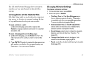
Changing Altimeter Settings
To change altimeter settings: 1.
Viewing Points on the Altimeter Plot Select individual points on the map.
2. On the Altimeter page, use...
Astro and DC 30 Owner's Manual - Page 38
...dog's saved track also changes the dog pointer color on the Map page. To save a portion of a track: 1. GPS Applications
Use the Saved Track page to rename the track and...Map
To calculate the area of the track log: 1. You can change the track color and the units for the track on the Dog Tracker page.
3. Use the Rocker to move the map pointer to the ending point and press ENTER > OK. Astro...
Astro and DC 30 Owner's Manual - Page 39
... will take you scroll, the elevation for each point appears at the bottom. 2. On the Saved Track page, press MENU > Profile. 2.
Topo maps.
On the Saved Track page, press MENU > Profile. Astro Dog Tracking System Owner's Manual
GPS Applications 3. Use the Rocker to move the map pointer to scroll across the track profile. To view...
Astro and DC 30 Owner's Manual - Page 40
... one of travel.
GPS Applications
4. With a saved track shown on the map, move the map
pointer to mark.
2. After entering and confirming your original path of the Find menu categories for the first
point on page 49.
Press MARK to 250 points each. Select OK to the route, repeat steps 2
through 5.
34
Astro Dog Tracking System...
Astro and DC 30 Owner's Manual - Page 41
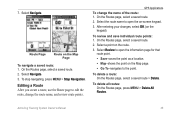
... for that route point.
• Save-saves the point as a location. • Map-shows the point on the Map page. • Go To-navigates to open the on the Map Page
To navigate a saved route: 1.
On the Routes page, select a saved route.
2. On the Routes page, select a saved route.
2.
To review and save individual route points: 1.
Astro Dog Tracking...
Astro and DC 30 Owner's Manual - Page 42
...Astro Dog Tracking System Owner's Manual GPS Applications
To select the off-road transition for
the two data fields at the bottom of the route when MapSource DEM U.S.
When you are within
that specified distance to your next point, you are routed to the following point. • Manual-When routing to your next point...route settings to the following point. Topo map data is used.
&#...
Astro and DC 30 Owner's Manual - Page 43
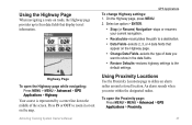
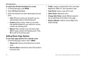
...map. Using Proximity Locations
Use the Proximity Locations page to a destination. • Data Fields-selects 2, 3, or 4 data fields that display travel information. Your course is represented by a center line.... • Change Data Fields-selects the type of the screen. Astro Dog Tracking System Owner's Manual
GPS Applications To change Highway settings: 1. On the Highway page, press MENU...
Astro and DC 30 Owner's Manual - Page 44
On the Proximity page, select an empty line > ENTER
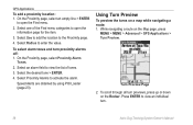
to enter the value. Select Radius to open the information page for the....
3. While navigating a route on a map while navigating a route: 1. Select Use to add the location to view an individual turn.
38
Astro Dog Tracking System Owner's Manual Press ENTER to the Proximity page.
4. GPS Applications
To add a proximity location: 1. ...
Astro and DC 30 Owner's Manual - Page 45
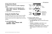
...)-turns the GPS receiver off or on the Map page, press
MENU > MENU > Advanced > GPS Applications > Active Route.
2.
Using the Satellite Page
The Satellite page shows the receiver status, the satellite locations, the satellite signal strength, and your current heading at least three satellites.
Select a turn to view an individual turn. Astro Dog Tracking...
Astro and DC 30 Owner's Manual - Page 61
no memory battery required
Map Storage:
microSD card capacity (a small portion of sight
Astro Dog Tracking System Owner's Manual 55
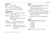
Use lithium batteries when ...lose capacity as temperature decreases. Accuracy GPS: < 33 ft. (10 m) 95%
DGPS: 10-16 ft. (3-5 m) 95% typical (WAAS accuracy in below-freezing conditions. Radio MURS (Multi-use ). line of the card capacity is used for...
Astro and DC 30 Owner's Manual - Page 70
... altimeter 30 map page 18 trip computer page 25 change dog unit type 10 change comm. symbol 11
A
accessories 41, 56 accuracy, GPS 55 active route 39 adding dogs to the dog list 12 addresses 22 alarms
marine 51 proximity 37, 44 alarm tones 38 alert GPS lost 45 lost communication 45 on-point 45...
Astro and DC 30 Owner's Manual - Page 71
...
finding 21 setup 51
go to 9, 20 go to marked location 14 GPS
applications 24 lost alert 45...map 9, 20
datum 52 orientation 47 map page 17 map data fields 18 measuring distance 19 options menu 17
Index
map setup general page 47 information page 48 marine page 49 points...map page 15 marking hunting-specific locations 15 MARK key 3, 15 mass storage mode 44 measuring distance 19 MENU key 3
Astro...
Astro and DC 30 Owner's Manual - Page 73

storage 61 sunrise 14 sunset 14 symbol set 49
T
time setup 51 tones setup 46 TracBack 33 tracking a dog 10 track log 31 track profile, zooming 33 tracks 30
...24 turn preview page 38
U
units of measure 52 units setup 52
updating software Astro 220 58 DC 30 59
upgrade dog unit 10 USB drivers 56 use map data 33 use track data 33 use with GPS on or off 39 UTC offset 51
V
version 44 view card info 44,...
Astro and DC 40 Quick Start Manual - Page 2

...an ID number is currently open.
Press to view the map. Press to view the Dog Tracker page. by phone at 0808 2380000.
• In Europe, go to www.garmin .com/support, or contact Garmin USA...the USA, go to open the main menu.
MENU
ENT (ENTER) Rocker IN OUT
Press to www.garmin .com/support and click Contact
Support for in Taiwan
Astro®
quick start manual
GPS-enabled dog ...
Similar Questions

I Have Downloaded Birdseye Map To My Garmin Astro 320 And I Keep Getting An
invalid JNX file come up when I turn on the GPS. The gps allows me to continue on loading more area ...
invalid JNX file come up when I turn on the GPS. The gps allows me to continue on loading more area ...
(Posted by SCOR88PION 9 years ago)

Garmin Edge 500 Wont Go Into Mass Storage Mode
(Posted by Peser 10 years ago)

How To Fix A Garmin Gps Astro 220 Tracking System
(Posted by mjlegnatash 10 years ago)

How Can I Save My Tracks To The Map On The Astro 320 There Are Road I Want To Sa
(Posted by gdigger11 11 years ago)