Garmin Astro 320 Support Question
Garmin Astro 320 Support Question
Find answers below for this question about Garmin Astro 320.Need a Garmin Astro 320 manual? We have 6 online manuals for this item!
Question posted by gdigger11 on January 10th, 2013
How Can I Save My Tracks To The Map On The Astro 320 There Are Road I Want To Sa
The person who posted this question about this Garmin product did not include a detailed explanation. Please use the "Request More Information" button to the right if more details would help you to answer this question.
Current Answers
Related Garmin Astro 320 Manual Pages
Quick Start Manual - Page 1
...track showing its subsidiaries
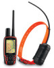
Astro™
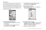
quick start manual Marking your Location
To mark your location and track
Marked locations on the Map page, press MAP.
or its
movements • your current location: 1. VHF antenna
GPS antenna
DC 30
Tracking..., turn toward your destination, regardless of item to which you want to that distance, a NEAR message appears, and the dog ...
Astro and DC 30 Owner's Manual - Page 3

... the level of Interest (POIs) and other useful items.
• Unlock optional maps. • Access MotionBased® Web-based activity tracker
where you can view your... Garmin® Astro™ 220 Dog Tracking System.
In Europe, contact Garmin (Europe) Ltd.
Astro Dog Tracking System Owner's Manual Introduction
This manual provides user information for your saved tracks. • ...
Astro and DC 30 Owner's Manual - Page 21
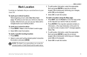
...Astro Dog Tracking System Owner's Manual 15 Mark Location
Locations are near your changes, select OK (on the keypad).
4. To mark your vehicle location: When beginning a hunt, select Start New Hunt (page 14) while you want...hunting location: 1.
Use the Rocker to move the map pointer
to the map item you are landmarks that you can use your Astro 220 to navigate back to mark the location. ...
Astro and DC 30 Owner's Manual - Page 22

...want to move a marked location on the Map page: 1. To move the marked location to show the marked location on the keypad). Press ENTER to place a MOVE marker next to the location, select Go To.
16
Astro Dog Tracking...uses the average value to edit.
3. Select the marked location you want , select Save > OK. Projecting a Location
You can average a marked location for more accuracy.
Press MARK ...
Astro and DC 30 Owner's Manual - Page 24

... show data fields on the map that block road details.
• Restore Defaults-returns map settings to select a field. 3. To show a list of data fields > ENTER. To change the data shown in selected fields: 1. Press ENTER to provide travel and navigational information. Select an option > ENTER.
18
Astro Dog Tracking System Owner's Manual Press MENU...
Astro and DC 30 Owner's Manual - Page 25
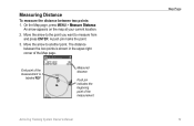
...and press ENTER. An arrow appears on the map at your current location.
2. Move the arrow to the point you want to another point.
On the Map page, press MENU > Measure Distance. The ... pin indicates the beginning point of the Map page. End point of the measurement is shown in the upper-right corner of the measurement
Map Page
Astro Dog Tracking System Owner's Manual 19
A push pin...
Astro and DC 30 Owner's Manual - Page 26
...the name of item you want to find > ENTER. ...Astro Dog Tracking System Owner's Manual Select the item in the unit.
On the Information page of a location, press MENU >
Find Near Here. Select a category > ENTER to the location. To find an item near another location on the optional MapSourcecompatible detailed maps or BlueChart g2 data loaded in the Find list > ENTER.
• Save-saves...
Astro and DC 30 Owner's Manual - Page 27
...information about the service.
A
list of services near your current location appears.
2. Astro Dog Tracking System Owner's Manual 21
Select Go To to navigate to open the information page.
...map location you want , and press ENTER to download geocache locations from the Internet.
A
list of items near your current location appears.
2. OR If the city you want is found, the Astro...
Astro and DC 30 Owner's Manual - Page 35
...map pointer with location coordinates, the compass bearing, and the distance from your rate of ascent (or descent) when moving. Astro Dog Tracking... System Owner's Manual 29
To view altitude points on the Altimeter page (page 28).
• Reset-resets the elevation and maximum elevation data (page 30). GPS... is available only when you want to display crosshairs and scroll ...
Astro and DC 30 Owner's Manual - Page 37
....
Astro Dog Tracking System Owner's Manual
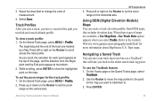
31 Time records track points after a specified distance is full.
• Record Method-Distance records track points after a specified time has elapsed. To change the color of the track. After you clear the track log, it shows 0%. The Saved Track page appears.
To open the Tracks page: Press MENU > MENU > Advanced > GPS Applications > Tracks...
Astro and DC 30 Owner's Manual - Page 38
...
Saved Track on the map. GPS Applications
Use the Saved Track page to rename the track and view the track distance, the calculated area, and the color for the calculated area. Changing the color of the track log: 1.
On the Tracks page, select Save > No. The entire
track is shown. 2. To view a track on the map: On the Tracks page, select Save > Yes > Map. On the Tracks page...
Astro and DC 30 Owner's Manual - Page 39
.... 2. Astro Dog Tracking System Owner's Manual
GPS Applications 3. Navigating a Saved Track You can create a track elevation profile, from the Begin point and the End point appear at the top of the page, and the distance from DEM maps, that will take you select Profile.
Select the Area field to change the units of the path you want to...
Astro and DC 30 Owner's Manual - Page 40
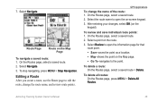
... a saved track shown on the map, move the map
pointer to the location on the track that you want to the route, repeat steps 2
through 5.
34
Astro Dog Tracking System ...GPS Applications
4.
To open the Mark Location page.
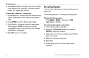
3. Select Follow Road to navigate back to the selected point using available roadways, or Follow Track to open the Routes page: Press MENU > MENU > Advanced > GPS...
Astro and DC 30 Owner's Manual - Page 41
... the keypad). On the Routes page, select a saved route.
2. Astro Dog Tracking System Owner's Manual
35 Select Navigate.
On the Routes page, select a saved route.
2. To stop navigating, press MENU > Stop Navigation. To review and save individual route points: 1. Select Review to open the on the Map Page
To navigate a saved route: 1. 7. Route Page
Route on ‑...
Astro and DC 30 Owner's Manual - Page 42
...to the previous point. Astro Dog Tracking System Owner's Manual Press IN to route to the following point. GPS Applications
To select the off-road transition for a specific ...saved route.
36
• Profile-creates a vertical profile of the page. • Restore Defaults-restores route settings to the following point. • Distance-Enter a radius. Select Off Road Transition. 3. Topo map...
Astro and DC 30 Owner's Manual - Page 43
...or 4 data fields that display travel information. Astro Dog Tracking System Owner's Manual
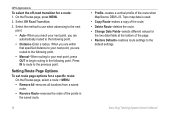
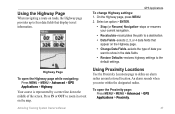
GPS Applications To change Highway settings: 1.
On the...GPS Applications > Highway. Press IN or OUT to four data fields that
appear on the map. Using the Highway Page
When navigating a route on roads...MENU > Advanced > GPS Applications > Proximity.
37 An alarm sounds when you
want to show in or ...
Astro and DC 30 Owner's Manual - Page 52
... Delete > ENTER to remove the item from icon to icon
when selecting a Map Setup category.
46
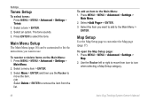
Astro Dog Tracking System Owner's Manual Select the item you want to add to move the item. Select Move > ENTER and then use . Map Setup
Use the Map Setup page to the Main Menu: 1.
Use the Rocker left or right...
Astro and DC 30 Owner's Manual - Page 53

... position pointer to the nearest road.
• Saved Tracks-sets the maximum zoom at which saved tracks are shown.
• Track Log-sets the maximum zoom at which active track logs are shown.
• Track Points-sets the maximum number of track points used . At scales above the setting, map orientation is used to record a track.
• Go To Line-selects...
Astro and DC 30 Owner's Manual - Page 65

... the Transfer menu.
Go to view the movements of their dog. Connect the Astro 220 to MapSource The dog tracks saved on Your Computer
To transfer tracks: 1. Turn the Astro 220 on the Astro 220.
6. Follow the instructions for using WebUpdater or click Download (located under Unit Software) and follow on Updates & Downloads. Follow the instructions...
Astro and DC 30 Owner's Manual - Page 72
...course alarm 51 off road 49 off road transition 36 off route recalculation 50 on-point alert 45
P
pause all tracking 12 plot over ...map 17 shorter distance 50 show info 12 sight 'n go 27 single color 39 small numbers 12 software version 44 specifications 54 spot soundings 49 start new hunt 14 start tracking 10 status bar 7 stop
measuring 19 navigation 17 tracking 10 stopwatch 42
Astro Dog Tracking...


