
Owners Manual
Page 2
... 18-25 Installation sequence for the suction-cup mount . . . . .18-19 Detaching the suction-cup mount 20 Installing the external GPS antenna (Optional 20-21 Installing Microsoft ActiveSync 22 Connecting the USB cable 22-23 Downloading files: ActiveSync 23 Data exchange via card reader 24... Downloading files: Removable disk 24 Disconnecting the USB device 25 Before operation 26-27 Starting up 26 Navigation features 27 Getting started with navigation 28-35 Navigation Menu 28 Address Screen 28 Recent Places Screen 28 My Places Screen 28 POI Screen 29 Route Manager Screen...
... 18-25 Installation sequence for the suction-cup mount . . . . .18-19 Detaching the suction-cup mount 20 Installing the external GPS antenna (Optional 20-21 Installing Microsoft ActiveSync 22 Connecting the USB cable 22-23 Downloading files: ActiveSync 23 Data exchange via card reader 24... Downloading files: Removable disk 24 Disconnecting the USB device 25 Before operation 26-27 Starting up 26 Navigation features 27 Getting started with navigation 28-35 Navigation Menu 28 Address Screen 28 Recent Places Screen 28 My Places Screen 28 POI Screen 29 Route Manager Screen...
Owners Manual
Page 4
Table of contents GPS Status 57 GPS Not Found 58 Map Setup 58-59 Tutorial 59 Help 59 Start Demo 59 Select Map 60 Initialize 60 Installation 61-63 Installing the Navigator "PC Portal 61-62 Recommended PC System Requirements 62 Starting the "PC Portal" Wizard 63 Using software 64-71 Using the "PC...
Table of contents GPS Status 57 GPS Not Found 58 Map Setup 58-59 Tutorial 59 Help 59 Start Demo 59 Select Map 60 Initialize 60 Installation 61-63 Installing the Navigator "PC Portal 61-62 Recommended PC System Requirements 62 Starting the "PC Portal" Wizard 63 Using software 64-71 Using the "PC...
Owners Manual
Page 17
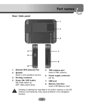
Docking connector 4. Power supply connector DC 5V 7. Speaker Gives a voice guidance service. 3. Memory Card Slot Insert a SD Memory Card. OFF: Slide switch down. 5. TMC antenna port Insert a TMC antenna. 6. Deleting or altering the map data in the built-in memory or the SD memory card randomly, may cause problems in the navigation function. 17 Power ON / OFF button ON: Slide switch up. USB port 8. Rear / Side panel Part names 1 2 3 4 7 5 8 6 1. External GPS Antenna Port 2.
Docking connector 4. Power supply connector DC 5V 7. Speaker Gives a voice guidance service. 3. Memory Card Slot Insert a SD Memory Card. OFF: Slide switch down. 5. TMC antenna port Insert a TMC antenna. 6. Deleting or altering the map data in the built-in memory or the SD memory card randomly, may cause problems in the navigation function. 17 Power ON / OFF button ON: Slide switch up. USB port 8. Rear / Side panel Part names 1 2 3 4 7 5 8 6 1. External GPS Antenna Port 2.
Owners Manual
Page 26
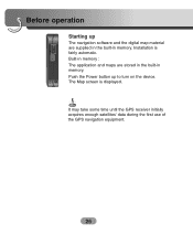
Installation is displayed. Push the Power button up The navigation software and the digital map material are stored in the built-in memory. The Map screen is fairly automatic. Built-in memory : The application and maps are supplied in the built-in memory. Before operation Starting up to turn on the device. It may take some time until the GPS receiver initially acquires enough satellites' data during the first use of the GPS navigation equipment. 26
Installation is displayed. Push the Power button up The navigation software and the digital map material are stored in the built-in memory. The Map screen is fairly automatic. Built-in memory : The application and maps are supplied in the built-in memory. Before operation Starting up to turn on the device. It may take some time until the GPS receiver initially acquires enough satellites' data during the first use of the GPS navigation equipment. 26

Owners Manual
Page 31
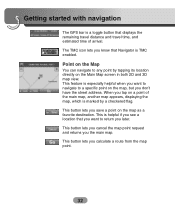
... view with the forward direction at the top. 2D map view with the next turn on the Navigation menu screens, the Main Map screen appears. When you have calculated a route, the Directions bar ... direction arrow and the distance to increase or decrease the detail of the route. Getting started with navigation Main Map When you tap the "Map" button on with North at the top. Current location in... Vehicle (Pedestrian) Mode. Last known location when GPS signal is the street that you will turn maneuver. 31 You can use the icons displayed on...
... view with the forward direction at the top. 2D map view with the next turn on the Navigation menu screens, the Main Map screen appears. When you have calculated a route, the Directions bar ... direction arrow and the distance to increase or decrease the detail of the route. Getting started with navigation Main Map When you tap the "Map" button on with North at the top. Current location in... Vehicle (Pedestrian) Mode. Last known location when GPS signal is the street that you will turn maneuver. 31 You can use the icons displayed on...
Owners Manual
Page 32
...route from the map point. 32 This button lets you the main map. Getting started with navigation The GPS bar is a toggle button that Navigator is TMC enabled. This feature is especially helpful when you tap on a point of arrival...displaying the map, which is helpful if you see a location that you want to navigate to return you don't have the street address. This is marked by tapping its location directly on the ...Map You can navigate to any point by a checkered flag. Point on the Main Map screen in both 2D and...
...route from the map point. 32 This button lets you the main map. Getting started with navigation The GPS bar is a toggle button that Navigator is TMC enabled. This feature is especially helpful when you tap on a point of arrival...displaying the map, which is helpful if you see a location that you want to navigate to return you don't have the street address. This is marked by tapping its location directly on the ...Map You can navigate to any point by a checkered flag. Point on the Main Map screen in both 2D and...
Owners Manual
Page 48
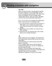
...country that you are currently traveling in the following order: 1. If you do not receive any message after completing traffic service free trial or subscription, the expiration date will turn green when GPS signal is acquired) If you may not display the accurate expiration date. If you ...turner scanning but not locking on the screen. 48 Finding a location with navigation Test TMC : When you tap this button, please check in . However, if the unit acquires GPS signal after tapping this button, The Navigation expands the search radius for to the "Whole Map" for one minute ...
...country that you are currently traveling in the following order: 1. If you do not receive any message after completing traffic service free trial or subscription, the expiration date will turn green when GPS signal is acquired) If you may not display the accurate expiration date. If you ...turner scanning but not locking on the screen. 48 Finding a location with navigation Test TMC : When you tap this button, please check in . However, if the unit acquires GPS signal after tapping this button, The Navigation expands the search radius for to the "Whole Map" for one minute ...
Owners Manual
Page 57
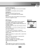
... automatically acquired and your location. Number of Satellites: You can not be acquired for navigation. GPS Status The Navigator uses the GPS receiver to find its initial location. The following GPS information is too low and unreliable for long, please restart whole navigation system by kilometers or miles per hour. Altitude: The height above sea level. Traveling...
... automatically acquired and your location. Number of Satellites: You can not be acquired for navigation. GPS Status The Navigator uses the GPS receiver to find its initial location. The following GPS information is too low and unreliable for long, please restart whole navigation system by kilometers or miles per hour. Altitude: The height above sea level. Traveling...
Owners Manual
Page 58
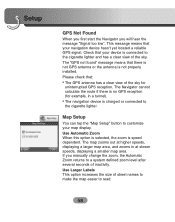
...map easier to a system defined zoom level after several seconds of the sky. Please check that your navigation device hasn't yet located a reliable GPS signal. Check that there is not GPS antenna or the antenna is not properly installed. The map zooms out at slower speeds, displaying a ...smaller map area. The "GPS not found" message means that your map display. Setup GPS Not Found When you first start the Navigator you manually change the zoom, the Automatic Zoom returns to read. 58 The Navigator cannot calculate the route if there is speed dependent...
...map easier to a system defined zoom level after several seconds of the sky. Please check that your navigation device hasn't yet located a reliable GPS signal. Check that there is not GPS antenna or the antenna is not properly installed. The map zooms out at slower speeds, displaying a ...smaller map area. The "GPS not found" message means that your map display. Setup GPS Not Found When you first start the Navigator you manually change the zoom, the Automatic Zoom returns to read. 58 The Navigator cannot calculate the route if there is speed dependent...
Owners Manual
Page 64
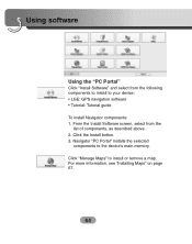
Using software Using the "PC Portal" Click "Install Software" and select from the list of components, as described above. 2. From the Install Software screen, select from the following components to install to your device: • LGE: GPS navigation software • Tutorial: Tutorial guide To install Navigator components: 1. For more information, see "Installing Maps" on page 67. 64 Click the Install button. 3. Navigator "PC Portal" installs the selected components to install or remove a map. Click "Manage Maps" to the device's main memory.
Using software Using the "PC Portal" Click "Install Software" and select from the list of components, as described above. 2. From the Install Software screen, select from the following components to install to your device: • LGE: GPS navigation software • Tutorial: Tutorial guide To install Navigator components: 1. For more information, see "Installing Maps" on page 67. 64 Click the Install button. 3. Navigator "PC Portal" installs the selected components to install or remove a map. Click "Manage Maps" to the device's main memory.
Owners Manual
Page 76
...condition, and surrounding obstacles. Troubleshooting Navigation program and map data protection • If you are under a tree, move to a location where there aren't any obstacles. • Check the GPS receiving condition from the GPS menu. 76 When initially connecting the GPS, it will be out of ... in LGE folder) in Built-in memory which are provided by using ActiveSync. (It contains important data for navigation. Cannot identify the current location. (GPS not receiving) GPS cannot be used indoors and must be seen well. It means it usually takes about 10 minutes to the product...
...condition, and surrounding obstacles. Troubleshooting Navigation program and map data protection • If you are under a tree, move to a location where there aren't any obstacles. • Check the GPS receiving condition from the GPS menu. 76 When initially connecting the GPS, it will be out of ... in LGE folder) in Built-in memory which are provided by using ActiveSync. (It contains important data for navigation. Cannot identify the current location. (GPS not receiving) GPS cannot be used indoors and must be seen well. It means it usually takes about 10 minutes to the product...
Owners Manual
Page 77
Even though GPS is provided. Cannot see the map even when you have executed the navigation menu. If the problem persists after the installation, contact the Customer Service Center. Refer to the homepage for newly constructed roads, the problem could be .... • When driving through the mountain or where the road is an adjacent road when turning. • When driving on the map in "Setup". When GPS receiver is installed, there can be different from the actual path. (Path guide error) • When the road is closely parallel. • When the splitting road...
Even though GPS is provided. Cannot see the map even when you have executed the navigation menu. If the problem persists after the installation, contact the Customer Service Center. Refer to the homepage for newly constructed roads, the problem could be .... • When driving through the mountain or where the road is an adjacent road when turning. • When driving on the map in "Setup". When GPS receiver is installed, there can be different from the actual path. (Path guide error) • When the road is closely parallel. • When the splitting road...
Owners Manual
Page 78
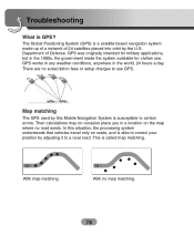
... able to correct your position by adjusting it to a near road. With map matching. GPS was originally intended for civilian use GPS. GPS GPS GPS GPS Map matching The GPS used by the U.S. This is GPS? In this Mobile Navigation System is a satellite-based navigation system made the system available for military applications, but in the 1980s, the government made...
... able to correct your position by adjusting it to a near road. With map matching. GPS was originally intended for civilian use GPS. GPS GPS GPS GPS Map matching The GPS used by the U.S. This is GPS? In this Mobile Navigation System is a satellite-based navigation system made the system available for military applications, but in the 1980s, the government made...


