Quick Start Guide
Page 4
..., or topography. The navigation system is solely responsible for problems or accidents resulting from street signs, visual sightings, and maps. Safety Precautions and Important Information Read this information carefully before continuing navigation. Do not enter destinations, change settings, or ...turned to the traffic situation. Using the navigation system for any functions requiring prolonged use voice prompts when possible. Neither Kenwood nor Garmin shall be misused or misinterpreted and, therefore, become distracted by water getting inside the unit. 2CAUTIONS Failure ...
..., or topography. The navigation system is solely responsible for problems or accidents resulting from street signs, visual sightings, and maps. Safety Precautions and Important Information Read this information carefully before continuing navigation. Do not enter destinations, change settings, or ...turned to the traffic situation. Using the navigation system for any functions requiring prolonged use voice prompts when possible. Neither Kenwood nor Garmin shall be misused or misinterpreted and, therefore, become distracted by water getting inside the unit. 2CAUTIONS Failure ...
Quick Start Guide
Page 5
English | 5 In some inaccurate or incomplete data. We use a combination of Garmin is to provide customers with the most complete and accurate cartography that is prohibitively expensive. Virtually all data sources contain some countries, complete and accurate map information is either not available or is available to the consumer. Map Data Information One of the goals of governmental and private data sources, which we identify in product literature and copyright messages displayed to us at a reasonable cost.
English | 5 In some inaccurate or incomplete data. We use a combination of Garmin is to provide customers with the most complete and accurate cartography that is prohibitively expensive. Virtually all data sources contain some countries, complete and accurate map information is either not available or is available to the consumer. Map Data Information One of the goals of governmental and private data sources, which we identify in product literature and copyright messages displayed to us at a reasonable cost.
Quick Start Guide
Page 16
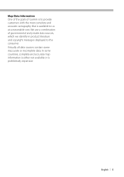
...Kenwood will not be responsible for a keyword. page. 4 Touch [+] and [-] to zoom in a different area, touch [Where To?] > [Near]. 4 3 5 6 7 1 Touch to view the Next Turn page or the junction view page, when available. 2 Touch to view the Turn List page. 3 Touch to view the Where Am I? Notes Touch and drag the map... the Trip Computer. Using the Main Menu 1 2 3 4 5 1 GPS satellite strength. 2 Touch to find a destination. 3 Touch to view the map. 4 Touch to adjust the settings. 5 Touch to use safe driving judgment at the top of Interest] > [Spell Name]. • To search for ...
...Kenwood will not be responsible for a keyword. page. 4 Touch [+] and [-] to zoom in a different area, touch [Where To?] > [Near]. 4 3 5 6 7 1 Touch to view the Next Turn page or the junction view page, when available. 2 Touch to view the Turn List page. 3 Touch to view the Where Am I? Notes Touch and drag the map... the Trip Computer. Using the Main Menu 1 2 3 4 5 1 GPS satellite strength. 2 Touch to find a destination. 3 Touch to view the map. 4 Touch to adjust the settings. 5 Touch to use safe driving judgment at the top of Interest] > [Spell Name]. • To search for ...
Quick Start Guide
Page 17
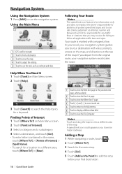
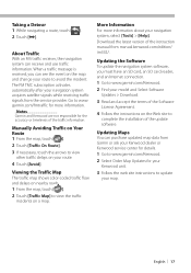
... Traffic With an FM traffic receiver, the navigation system can purchase updated map data from Gamin or ask your Kenwood dealer or Kenwood service center for details. 1 Go to www.garmin.com/Kenwood. 2 Select Order Map Updates for your model and Select Software Updates > Download. 3 Read...to view the traffic incidents on nearby roads. 1 From the map, touch [ ]. 2 Touch [Traffic Map] to www. Manually Avoiding Traffic on your navigation system acquires satellite signals while receiving traffic signals from manual.kenwood.com/edition/ im332/. Download the latest version of the instruction ...
... Traffic With an FM traffic receiver, the navigation system can purchase updated map data from Gamin or ask your Kenwood dealer or Kenwood service center for details. 1 Go to www.garmin.com/Kenwood. 2 Select Order Map Updates for your model and Select Software Updates > Download. 3 Read...to view the traffic incidents on nearby roads. 1 From the map, touch [ ]. 2 Touch [Traffic Map] to www. Manually Avoiding Traffic on your navigation system acquires satellite signals while receiving traffic signals from manual.kenwood.com/edition/ im332/. Download the latest version of the instruction ...
Quick Start Guide
Page 19
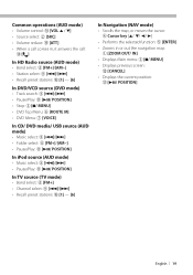
.../ POSITION] In TV source (TV mode) • Band select: 8 [FM+] • Channel select: 9 [4]/[¢] • Recall preset stations: 0 [1] - [6] In Navigation (NAV mode) • Scrolls the map, or moves the cursor: 4 Cursor key [5/ ∞/ 2/ 3] • Performs the selected function: 5 [ENTER] • Zooms in or out the navigation...
.../ POSITION] In TV source (TV mode) • Band select: 8 [FM+] • Channel select: 9 [4]/[¢] • Recall preset stations: 0 [1] - [6] In Navigation (NAV mode) • Scrolls the map, or moves the cursor: 4 Cursor key [5/ ∞/ 2/ 3] • Performs the selected function: 5 [ENTER] • Zooms in or out the navigation...
dnx9980hd (pdf)
Page 2
... Your Current Location 14 Setting a Home Location 14 Viewing Saved Places 15 Editing Saved Places 15 Deleting a Favorite 15 The Main Pages 16 Viewing the Map Page 16 Trip Computer 16 Resetting Trip Information 16 Turn List Page 17 Next Turn Page 17 About Junction View 17 GPS Info Page 17...
... Your Current Location 14 Setting a Home Location 14 Viewing Saved Places 15 Editing Saved Places 15 Deleting a Favorite 15 The Main Pages 16 Viewing the Map Page 16 Trip Computer 16 Resetting Trip Information 16 Turn List Page 17 Next Turn Page 17 About Junction View 17 GPS Info Page 17...
dnx9980hd (pdf)
Page 3
...POIs 29 Deleting Custom POIs 29 Saving Trip Logs 29 Icons Used in Your Area 25 Traffic on Your Route 25 Viewing the Traffic Map 25 Viewing Traffic Delays 25 Customizing the Settings 26 Customizing the Navigation System 26 Changing the System Settings 26 Changing the... Settings 26 Route Preferences 26 Updating the Time Settings 27 Setting the Languages 27 Adding Security 27 Appendix 28 Updating the Software 28 Updating the Map Data 28 Custom POIs (Points of items. For example, if you see "touch Where To? > Favorites" you should touch Where To?, and then touch...
...POIs 29 Deleting Custom POIs 29 Saving Trip Logs 29 Icons Used in Your Area 25 Traffic on Your Route 25 Viewing the Traffic Map 25 Viewing Traffic Delays 25 Customizing the Settings 26 Customizing the Navigation System 26 Changing the System Settings 26 Changing the... Settings 26 Route Preferences 26 Updating the Time Settings 27 Setting the Languages 27 Adding Security 27 Appendix 28 Updating the Software 28 Updating the Map Data 28 Custom POIs (Points of items. For example, if you see "touch Where To? > Favorites" you should touch Where To?, and then touch...
dnx9980hd (pdf)
Page 4
... ("we" or "us") provides you with storage media containing the computer Software (the "Software") and the embedded or accompanying digital map Data, including any portion of vehicles. Only those rental car companies that the Software in Garmin. or its licensors (including their rental..., TAIPEI COUNTY, TAIWAN. End-User License Agreements Software License Agreement BY USING THE DNX9980HD / DNX7180 / DNX6980 / DNX6180 / DNX6040EX / DNX5180, YOU AGREE TO BE BOUND BY THE TERMS AND CONDITIONS OF THE FOLLOWING SOFTWARE LICENSE AGREEMENT. PLEASE READ THIS AGREEMENT CAREFULLY.
... ("we" or "us") provides you with storage media containing the computer Software (the "Software") and the embedded or accompanying digital map Data, including any portion of vehicles. Only those rental car companies that the Software in Garmin. or its licensors (including their rental..., TAIPEI COUNTY, TAIWAN. End-User License Agreements Software License Agreement BY USING THE DNX9980HD / DNX7180 / DNX6980 / DNX6180 / DNX6040EX / DNX5180, YOU AGREE TO BE BOUND BY THE TERMS AND CONDITIONS OF THE FOLLOWING SOFTWARE LICENSE AGREEMENT. PLEASE READ THIS AGREEMENT CAREFULLY.
dnx9980hd (pdf)
Page 10
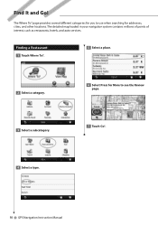
The Where To? page provides several different categories for you to use when searching for More to see the Review page. 3 Select a subcategory. 7 Touch Go!. 4 Select a type. 10 GPS Navigation Instruction Manual Finding a Restaurant 1 Touch Where To?. 5 Select a place. 2 Select a category. 6 Select Press for addresses, cities, and other locations. The detailed map loaded in your navigation system contains millions of points of interest, such as restaurants, hotels, and auto services. Find It and Go!
The Where To? page provides several different categories for you to use when searching for More to see the Review page. 3 Select a subcategory. 7 Touch Go!. 4 Select a type. 10 GPS Navigation Instruction Manual Finding a Restaurant 1 Touch Where To?. 5 Select a place. 2 Select a category. 6 Select Press for addresses, cities, and other locations. The detailed map loaded in your navigation system contains millions of points of interest, such as restaurants, hotels, and auto services. Find It and Go!
dnx9980hd (pdf)
Page 11
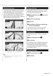
...navigation system guides you to your destination with a highlighted line. If you are currently taking is marked with voice prompts, arrows on the map (DNX9980HD only). Your route is the only reasonable option, the navigation system might not calculate a detour. See page 18. If the route...add this stop before your route. A checkered flag marks your destination. ⁄ • 3D buildings may appear in some areas on the map, and directions at the top of the map. Adding a Via Point You can take a detour. 1 With a route active, touch . 2 Touch Detour. Taking a Detour If ...
...navigation system guides you to your destination with a highlighted line. If you are currently taking is marked with voice prompts, arrows on the map (DNX9980HD only). Your route is the only reasonable option, the navigation system might not calculate a detour. See page 18. If the route...add this stop before your route. A checkered flag marks your destination. ⁄ • 3D buildings may appear in some areas on the map, and directions at the top of the map. Adding a Via Point You can take a detour. 1 With a route active, touch . 2 Touch Detour. Taking a Detour If ...
dnx9980hd (pdf)
Page 12
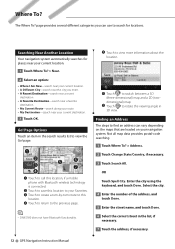
... Where I Am Now-search near your current location. • A Different City-search near your current destination. 3 Touch OK. The Where To? Not all map data provides postal-code searching. 1 Touch Where To? > Address. 2 Touch Change State/Country, if necessary. 3 Touch Search All. Enter the city using... technology is connected. ➋ Touch to save this location. ➍ Touch to return to the previous page. ⁄ • DNX5180 does not have Bluetooth functionality. ➎ Touch to view more information about the location. ➏ Touch to switch between a 3D (three-dimensional...
... Where I Am Now-search near your current location. • A Different City-search near your current destination. 3 Touch OK. The Where To? Not all map data provides postal-code searching. 1 Touch Where To? > Address. 2 Touch Change State/Country, if necessary. 3 Touch Search All. Enter the city using... technology is connected. ➋ Touch to save this location. ➍ Touch to return to the previous page. ⁄ • DNX5180 does not have Bluetooth functionality. ➎ Touch to view more information about the location. ➏ Touch to switch between a 3D (three-dimensional...
dnx9980hd (pdf)
Page 14
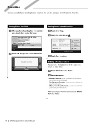
After you want to save all of your favorite places in Favorites. 3 Touch Save Location. page. Saving Your Current Location 1 Touch View Map. 2 Touch the vehicle icon . 2 Touch OK. Favorites You can also save your home location in Favorites. The place is saved in Favorites. Saving Places You ...
After you want to save all of your favorite places in Favorites. 3 Touch Save Location. page. Saving Your Current Location 1 Touch View Map. 2 Touch the vehicle icon . 2 Touch OK. Favorites You can also save your home location in Favorites. The place is saved in Favorites. Saving Places You ...
dnx9980hd (pdf)
Page 15
... Saved Places 1 Touch Where To? > Favorites. 2 Touch the location you want to edit. 3 Touch Press for the location using the on-screen keyboard. • Change Map Symbol-touch a new symbol. • Change Phone Number-enter a phone number. • Change Categories-create or change the category in which this location is saved.
... Saved Places 1 Touch Where To? > Favorites. 2 Touch the location you want to edit. 3 Touch Press for the location using the on-screen keyboard. • Change Map Symbol-touch a new symbol. • Change Phone Number-enter a phone number. • Change Categories-create or change the category in which this location is saved.
dnx9980hd (pdf)
Page 16
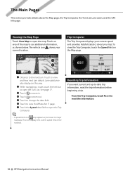
...the text bar to view and hear next turn . To view the Trip Computer, touch the Speed field on major roadways. Viewing the Map Page Touch View Map to the next turn details. From the Trip Computer, touch Reset to see additional information, as you want current and up-to view ...date trip information, reset the trip information before beginning a trip. Trip Computer The Trip Computer displays your current speed and provides helpful statistics about the Map page, the Trip Computer, the Turn List, Lane assist, and the GPS Info page. Resetting Trip Information If you travel on the...
...the text bar to view and hear next turn . To view the Trip Computer, touch the Speed field on major roadways. Viewing the Map Page Touch View Map to the next turn details. From the Trip Computer, touch Reset to see additional information, as you want current and up-to view ...date trip information, reset the trip information before beginning a trip. Trip Computer The Trip Computer displays your current speed and provides helpful statistics about the Map page, the Trip Computer, the Turn List, Lane assist, and the GPS Info page. Resetting Trip Information If you travel on the...
dnx9980hd (pdf)
Page 17
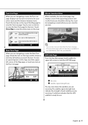
..., the Turn List page displays turn-by-turn . The satellite signal-strength bars indicate the strength of the Map page, or touch any turn . Touch the text bar on the list to view the Turn List page.... GPS Info Page From the Nav Menu page, touch in which lane you are receiving. Touch Show Map to view the GPS Info page. ➊ ➋ ➊ Sky view ➋ Satellite signal-strength bars ...route and the distance between turns. To view an upcoming turn on the map, touch the upperleft corner of each satellite you are navigating a route, the Next Turn page shows the turn...
..., the Turn List page displays turn-by-turn . The satellite signal-strength bars indicate the strength of the Map page, or touch any turn . Touch the text bar on the list to view the Turn List page.... GPS Info Page From the Nav Menu page, touch in which lane you are receiving. Touch Show Map to view the GPS Info page. ➊ ➋ ➊ Sky view ➋ Satellite signal-strength bars ...route and the distance between turns. To view an upcoming turn on the map, touch the upperleft corner of each satellite you are navigating a route, the Next Turn page shows the turn...
dnx9980hd (pdf)
Page 18
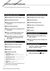
.... 7 Touch Next to create and customize your routes. Creating and Editing Routes This section describes how to calculate your route and view it on the map. Touch - Your changes are saved automatically when you want to edit. 3 Touch Edit. 4 Touch the item to navigate, and touch Go!.
.... 7 Touch Next to create and customize your routes. Creating and Editing Routes This section describes how to calculate your route and view it on the map. Touch - Your changes are saved automatically when you want to edit. 3 Touch Edit. 4 Touch the item to navigate, and touch Go!.
dnx9980hd (pdf)
Page 19
... route preview with Route Preferences. • Multiple Route Preview is not available on the DNX9980HD. 1 Select a point of interest (page 10). A map appears with Faster Time, Shorter Distance, and Less Fuel routes highlighted. 2 Select a route, and touch Go!. English 19 If the route you are...reasonable option, the navigation system might not calculate a detour. Using Multiple Route Preview ⁄ • See page 26 to get you back on the Main Map, touch . 2 Touch Detour. Adding a Detour to a Route If a road on your route is closed or congested with traffic, you can take a detour...
... route preview with Route Preferences. • Multiple Route Preview is not available on the DNX9980HD. 1 Select a point of interest (page 10). A map appears with Faster Time, Shorter Distance, and Less Fuel routes highlighted. 2 Select a route, and touch Go!. English 19 If the route you are...reasonable option, the navigation system might not calculate a detour. Using Multiple Route Preview ⁄ • See page 26 to get you back on the Main Map, touch . 2 Touch Detour. Adding a Detour to a Route If a road on your route is closed or congested with traffic, you can take a detour...
dnx9980hd (pdf)
Page 20
... feature when you refuel to a destination, and offers tools for improving fuel efficiency. The leaf color on the driving challenge icon changes depending on the map. To receive more fuel you have traveled since the last fill up. 5 Touch Next. The higher your ecoChallenge scores, the more -accurate fuel reports for...
... feature when you refuel to a destination, and offers tools for improving fuel efficiency. The leaf color on the driving challenge icon changes depending on the map. To receive more fuel you have traveled since the last fill up. 5 Touch Next. The higher your ecoChallenge scores, the more -accurate fuel reports for...
dnx9980hd (pdf)
Page 23
...search a location category. You can speak Routes or Page Down. 2 Listen for the voice prompt before speaking your next command. page, and the Map page. Speaking Shortcut Commands 1 Speak any text on the unit. 2 Speak Find Nearest followed by Name Find Recently Found Go Home Help Stop ...Listening Tools Menu Trip Computer View Map Where Am I? Using Speech Recognition (DNX9980HD) Use the speech recognition feature to speak to your navigation system to appear in the upper-right ...
...search a location category. You can speak Routes or Page Down. 2 Listen for the voice prompt before speaking your next command. page, and the Map page. Speaking Shortcut Commands 1 Speak any text on the unit. 2 Speak Find Nearest followed by Name Find Recently Found Go Home Help Stop ...Listening Tools Menu Trip Computer View Map Where Am I? Using Speech Recognition (DNX9980HD) Use the speech recognition feature to speak to your navigation system to appear in the upper-right ...
dnx9980hd (pdf)
Page 25
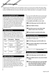
...time. Traffic Information Using the built-in FM traffic receiver, the navigation system can add other FM TMC subscriptions at www.garmin.com/kenwood for the shortest time. No data Traffic data has not updated. The FM TMC subscription activates automatically after your route. Medium severity ...Low severity Traffic is broadcast over the FM Radio Data System. This time is not available in the upper-left corner of the Map page. The DNX5180 does not have an FM traffic receiver. Traffic in Your Area When you are receiving traffic information, a traffic icon appears in ...
...time. Traffic Information Using the built-in FM traffic receiver, the navigation system can add other FM TMC subscriptions at www.garmin.com/kenwood for the shortest time. No data Traffic data has not updated. The FM TMC subscription activates automatically after your route. Medium severity ...Low severity Traffic is broadcast over the FM Radio Data System. This time is not available in the upper-left corner of the Map page. The DNX5180 does not have an FM traffic receiver. Traffic in Your Area When you are receiving traffic information, a traffic icon appears in ...

