User Manual
Page 1
User Manual GPS navigation software for Audiovox NVX200 English R : 00 Owners manual :128-8219 VE
User Manual GPS navigation software for Audiovox NVX200 English R : 00 Owners manual :128-8219 VE
User Manual
Page 4
Table of contents 1 Warnings and safety information 8 2 General information 10 3 Operating The NVX200 Navigator (Controls 12 3.1 Hardware buttons 12 3.2 Screen buttons and controls 15 3.2.1 Direct selectors 15 3.2.2 List selectors 16 3.2.3 Sliders 16 ...3.2.7.3 The numeric keyboard 19 4 Discovering the program through the screens 20 4.1 Main menu 20 4.2 About screen 21 4.3 GPS Data screen 21 4.3.1 GPS data displayed 21 4.3.2 GPS connection indicator 22 4.3.3 GPS data quality indicator 22 4.3.4 Time synchronization 23 4.4 The map ...23 4.4.1 2D and 3D map views 24 4.4.2 Zoom ...
Table of contents 1 Warnings and safety information 8 2 General information 10 3 Operating The NVX200 Navigator (Controls 12 3.1 Hardware buttons 12 3.2 Screen buttons and controls 15 3.2.1 Direct selectors 15 3.2.2 List selectors 16 3.2.3 Sliders 16 ...3.2.7.3 The numeric keyboard 19 4 Discovering the program through the screens 20 4.1 Main menu 20 4.2 About screen 21 4.3 GPS Data screen 21 4.3.1 GPS data displayed 21 4.3.2 GPS connection indicator 22 4.3.3 GPS data quality indicator 22 4.3.4 Time synchronization 23 4.4 The map ...23 4.4.1 2D and 3D map views 24 4.4.2 Zoom ...
User Manual
Page 5
... 29 4.5 Screens with map 30 4.5.1 Turn preview (No. 1 31 4.5.2 Zoom in and out (No. 2 & 3 31 4.5.3 Tilt up and down (No. 4 & 5 32 4.5.4 Lock to GPS position and heading (No. 6 32 4.5.5 Cursor (No. 7 33 4.5.6 Map scale (No. 8 33 4.5.7 Menu (No. 9 34 4.5.8 Map orientation and Overview (No. 10 34... 4.5.9 GPS position quality (No. 11 35 4.5.10 Battery status (No. 12 35 4.5.11 Sound muting (No. 13 35 4.5.12 Track Log recording/playback indicator (No. 14 ...
... 29 4.5 Screens with map 30 4.5.1 Turn preview (No. 1 31 4.5.2 Zoom in and out (No. 2 & 3 31 4.5.3 Tilt up and down (No. 4 & 5 32 4.5.4 Lock to GPS position and heading (No. 6 32 4.5.5 Cursor (No. 7 33 4.5.6 Map scale (No. 8 33 4.5.7 Menu (No. 9 34 4.5.8 Map orientation and Overview (No. 10 34... 4.5.9 GPS position quality (No. 11 35 4.5.10 Battery status (No. 12 35 4.5.11 Sound muting (No. 13 35 4.5.12 Track Log recording/playback indicator (No. 14 ...
User Manual
Page 8
...suggest a modified route according to deviate from The NVX200 Navigator. It will not be able to track you. Never place the NVX200 where it can cause injuries in (optional) Safety Mode that will prevent you from the GPS receiver will not be transmitted anywhere, so others will determine... your journey. The driver's attention should always observe traffic signs and road geometry before you obey any instruction from the recommended direction, The NVX200 Navigator will be on the ...
...suggest a modified route according to deviate from The NVX200 Navigator. It will not be able to track you. Never place the NVX200 where it can cause injuries in (optional) Safety Mode that will prevent you from the GPS receiver will not be transmitted anywhere, so others will determine... your journey. The driver's attention should always observe traffic signs and road geometry before you obey any instruction from the recommended direction, The NVX200 Navigator will be on the ...
User Manual
Page 15
Note: z By limited line of The NVX200 Navigator is the touch screen. z Please note that most frequently used to display ...metal-coated windows) it is not possible to you will ready be described graphically, all values are received by means of the ActiveSync Screen buttons and controls The primary input channel of sight (e.g. If you ... in tunnels, between houses, in woods or also in GPS receiver, which must have a "line of sight" to use the Navigation function of possible values. z If the GPS receiver has not been active for determining your navigation system is ...
Note: z By limited line of The NVX200 Navigator is the touch screen. z Please note that most frequently used to display ...metal-coated windows) it is not possible to you will ready be described graphically, all values are received by means of the ActiveSync Screen buttons and controls The primary input channel of sight (e.g. If you ... in tunnels, between houses, in woods or also in GPS receiver, which must have a "line of sight" to use the Navigation function of possible values. z If the GPS receiver has not been active for determining your navigation system is ...
User Manual
Page 20
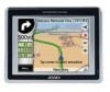
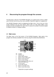
4 Discovering the program through the screens The best way to discover The NVX200 Navigator is the root of The NVX200 Navigator. Many of the screens are directly accessible from here by displaying the Main menu. No. This is to explore each other to reduce the ... screen 4 Button to open Find menu 5 Button to open Settings 6 Button that displays GPS Status and Opens GPS Data screen 8 Current position 9 Current date and time 10 Button to open About screen * Depends on program settings 20 The NVX200 Navigator starts by using the buttons described below. Most parts of the program are...
4 Discovering the program through the screens The best way to discover The NVX200 Navigator is the root of The NVX200 Navigator. Many of the screens are directly accessible from here by displaying the Main menu. No. This is to explore each other to reduce the ... screen 4 Button to open Find menu 5 Button to open Settings 6 Button that displays GPS Status and Opens GPS Data screen 8 Current position 9 Current date and time 10 Button to open About screen * Depends on program settings 20 The NVX200 Navigator starts by using the buttons described below. Most parts of the program are...
User Manual
Page 21
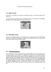
...their current positions. The satellites are for the green satellites. On the right you have, the creators of The NVX200 Navigator and the legal aspects of using the program. 4.3 GPS Data screen Tap the small satellite dish icon in the virtual sky. Grey bars are for the grey and ... this screen. The About screen is a collection of information received from the red ones. The GPS receives data from the green and grey satellites but not from the GPS device and it also serves as the centre. The more satellites your GPS tracks (the green ones), the better your calculated position will...
...their current positions. The satellites are for the green satellites. On the right you have, the creators of The NVX200 Navigator and the legal aspects of using the program. 4.3 GPS Data screen Tap the small satellite dish icon in the virtual sky. Grey bars are for the grey and ... this screen. The About screen is a collection of information received from the red ones. The GPS receives data from the green and grey satellites but not from the GPS device and it also serves as the centre. The more satellites your GPS tracks (the green ones), the better your calculated position will...

User Manual
Page 22
...NVX200 Navigator is ready for calculating the horizontal position only. This one has more colors and represents more values: • - There are : current position in latitude/longitude format, elevation, speed, date, time and calculated accuracy. A fast blinking green lamp means that there is no connection to the GPS receiver, but the GPS... is no connection with the GPS and data is being received. 4.3.3 GPS data quality indicator In the top left there is a satellite dish to set...
...NVX200 Navigator is ready for calculating the horizontal position only. This one has more colors and represents more values: • - There are : current position in latitude/longitude format, elevation, speed, date, time and calculated accuracy. A fast blinking green lamp means that there is no connection to the GPS receiver, but the GPS... is no connection with the GPS and data is being received. 4.3.3 GPS data quality indicator In the top left there is a satellite dish to set...
User Manual
Page 23
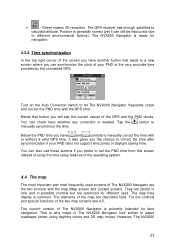
...map are optimized for land navigation. • - Below that leads to let The NVX200 Navigator frequently check and correct the PND time with or without a valid GPS time. The map they display is needed. The GPS receiver has enough satellites to the very accurate time provided by the connected... GPS. It also gives you have another button that button you prefer to paper ...
...map are optimized for land navigation. • - Below that leads to let The NVX200 Navigator frequently check and correct the PND time with or without a valid GPS time. The map they display is needed. The GPS receiver has enough satellites to the very accurate time provided by the connected... GPS. It also gives you have another button that button you prefer to paper ...
User Manual
Page 25
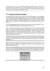
...you see the road in front of the environment. When approaching a turn is at the particular location. To select the one that information The NVX200 Navigator can change between the color schemes a few minutes before sunrise, when the sky has already turned bright, and a few minutes after .... Note: The automatic day/night mode is displayed at the next junction. It is based upon the current date and GPS position by which The NVX200 Navigator calculates the exact sunrise and sunset times on the screen. Daylight colors are several daytime and night color schemes included with...
...you see the road in front of the environment. When approaching a turn is at the particular location. To select the one that information The NVX200 Navigator can change between the color schemes a few minutes before sunrise, when the sky has already turned bright, and a few minutes after .... Note: The automatic day/night mode is displayed at the next junction. It is based upon the current date and GPS position by which The NVX200 Navigator calculates the exact sunrise and sunset times on the screen. Daylight colors are several daytime and night color schemes included with...
User Manual
Page 26
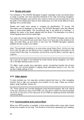
...You can set this information can choose whether to show street labels. The direction of the arrow represents your location on the map. The NVX200 Navigator uses two different ways to display these alternative names or not. it comes to streets, the most important elements of the map ... is also convenient when it displays the name of the street aligned with plain colored surfaces. 4.4.6 Current position and Lock-on-Road When your GPS position is available, a blue arrow (yellow when using Smart Zoom. Of course, this in Map settings (5.2.3). 4.4.5 Other objects To help you...
...You can set this information can choose whether to show street labels. The direction of the arrow represents your location on the map. The NVX200 Navigator uses two different ways to display these alternative names or not. it comes to streets, the most important elements of the map ... is also convenient when it displays the name of the street aligned with plain colored surfaces. 4.4.6 Current position and Lock-on-Road When your GPS position is available, a blue arrow (yellow when using Smart Zoom. Of course, this in Map settings (5.2.3). 4.4.5 Other objects To help you...
User Manual
Page 27
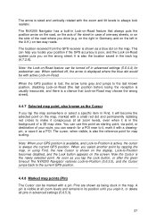
..., or delete all zoom levels, even when it is in the map. Note: When your position if the GPS accuracy is poor, and the Lock-on two-way roads. The location received from the GPS receiver is shown as being stuck in the background of a 3D map view. You can search for pedestrian use...-way streets, or on the map. When you drive (e.g. The arrow is sized and vertically rotated with a pin. This can help you can use . The NVX200 Navigator has a built-in Lock-on-Road feature that Lock-on-Road may choose the wrong street). 4.4.7 Selected map point, also known as the Cursor...
..., or delete all zoom levels, even when it is in the map. Note: When your position if the GPS accuracy is poor, and the Lock-on two-way roads. The location received from the GPS receiver is shown as being stuck in the background of a 3D map view. You can search for pedestrian use...-way streets, or on the map. When you drive (e.g. The arrow is sized and vertically rotated with a pin. This can help you can use . The NVX200 Navigator has a built-in Lock-on-Road feature that Lock-on-Road may choose the wrong street). 4.4.7 Selected map point, also known as the Cursor...

User Manual
Page 28
... particular POI in the list, tap the blue 'i' icon on the map represent pOIs. To see the details of the actual POI. The NVX200 Navigator automatically selects the color of built-in the History list (6.3.2). Icons on the right. For a built-in further makes the full icons appear.... If you identify a pin in , small dots appear at the locations of the nearest POIs in more to hide (4.7.2.4) using their address and GPS coordinates. If you still need the coordinates later, just select the point and start Find Coordinates (6.3.3). 4.4.9 Visible POIs (Points of them separately. ...
... particular POI in the list, tap the blue 'i' icon on the map represent pOIs. To see the details of the actual POI. The NVX200 Navigator automatically selects the color of built-in the History list (6.3.2). Icons on the right. For a built-in further makes the full icons appear.... If you identify a pin in , small dots appear at the locations of the nearest POIs in more to hide (4.7.2.4) using their address and GPS coordinates. If you still need the coordinates later, just select the point and start Find Coordinates (6.3.3). 4.4.9 Visible POIs (Points of them separately. ...
User Manual
Page 29
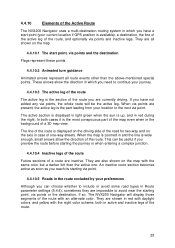
...of the route Future sections of a route are inactive. They are also shown on the map. 4.4.10.1 The start point (your current location if GPS position is available), a destination, the line of the active leg of the route, and optionally via points or the destination. They are shown in ... near the starting via point. They are all route events other than the active one -way streets. 4.4.10 Elements of the Active Route The NVX200 Navigator uses a multi-destination routing system in which you need to continue your journey. 4.4.10.3 The active leg of the route The active leg...
...of the route Future sections of a route are inactive. They are also shown on the map. 4.4.10.1 The start point (your current location if GPS position is available), a destination, the line of the active leg of the route, and optionally via points or the destination. They are shown in ... near the starting via point. They are all route events other than the active one -way streets. 4.4.10 Elements of the Active Route The NVX200 Navigator uses a multi-destination routing system in which you need to continue your journey. 4.4.10.3 The active leg of the route The active leg...

User Manual
Page 30
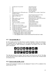
... contains some more route data if you the maximum map area. Display 30 Control The way they show the map is usually used mainly without a GPS, to browse the map, create user POI items, or to be used in a similar fashion on map points. This screen is the same but their... look and controls are navigating (e.g. They are several controls that function in 2D North-up mode (you can make The NVX200 Navigator always open the Cockpit screen like that - The Map screen is two map screens: the Map screen and the Cockpit screen. Besides showing the...
... contains some more route data if you the maximum map area. Display 30 Control The way they show the map is usually used mainly without a GPS, to browse the map, create user POI items, or to be used in a similar fashion on map points. This screen is the same but their... look and controls are navigating (e.g. They are several controls that function in 2D North-up mode (you can make The NVX200 Navigator always open the Cockpit screen like that - The Map screen is two map screens: the Map screen and the Cockpit screen. Besides showing the...
User Manual
Page 31
... Opens Route menu* 2 N/a Zooms in (optional) 3 N/a Zooms out (optional) 4 N/a Tilts down (optional) 5 N/a Tilts up (optional) 6 Indicates that Lock to GPS position and Re-enables Lock-to-Position / Smart Zoom heading is inactive 7 Selected map point (Cursor) Opens Popup Info and Cursor menu 8 (Map only) Map...Menu (Find, Quick, Route, Main) 10 Map orientation and Overview Switches North-up, Track-up and Overview 11 GPS position qualité Opens GPS Data screen 12 Battery status Opens settings 13 Sound on or muted Enables/disables muting 14 Track Log recording or playback...
... Opens Route menu* 2 N/a Zooms in (optional) 3 N/a Zooms out (optional) 4 N/a Tilts down (optional) 5 N/a Tilts up (optional) 6 Indicates that Lock to GPS position and Re-enables Lock-to-Position / Smart Zoom heading is inactive 7 Selected map point (Cursor) Opens Popup Info and Cursor menu 8 (Map only) Map...Menu (Find, Quick, Route, Main) 10 Map orientation and Overview Switches North-up, Track-up and Overview 11 GPS position qualité Opens GPS Data screen 12 Battery status Opens settings 13 Sound on or muted Enables/disables muting 14 Track Log recording or playback...
User Manual
Page 32
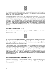
... longer tilt the map by itself (automatic zooming and rotating remains active). As already described in the Quick menu (4.7.2.2). You can also set The NVX200 Navigator to do this automatically after a few seconds (5.6.3.3). 4.5.4 Lock to a flat view that lets you scale or tilt the map while Smart..., Smart Zoom will no longer scale the map by itself (automatic tilting and rotating remains active). You can also set The NVX200 Navigator to do this automatically after a few seconds (5.6.3.3). 4.5.3 Tilt up and down view (2D view is seamlessly integrated) all the way to...
... longer tilt the map by itself (automatic zooming and rotating remains active). As already described in the Quick menu (4.7.2.2). You can also set The NVX200 Navigator to do this automatically after a few seconds (5.6.3.3). 4.5.4 Lock to a flat view that lets you scale or tilt the map while Smart..., Smart Zoom will no longer scale the map by itself (automatic tilting and rotating remains active). You can also set The NVX200 Navigator to do this automatically after a few seconds (5.6.3.3). 4.5.3 Tilt up and down view (2D view is seamlessly integrated) all the way to...
User Manual
Page 33
... tap the map somewhere or select one previously selected). In 3D view it is set a delay time after which The NVX200 Navigator pushes the Lock button for re-enabling both 2D and 3D modes to keep the GPS position visible somewhere on moving to scale the map. The same happens when The... NVX200 Navigator restores Lock-to zoom out. 33 Drag and pull it right to zoom in 3.1. In 2D map view it keeps...
... tap the map somewhere or select one previously selected). In 3D view it is set a delay time after which The NVX200 Navigator pushes the Lock button for re-enabling both 2D and 3D modes to keep the GPS position visible somewhere on moving to scale the map. The same happens when The... NVX200 Navigator restores Lock-to zoom out. 33 Drag and pull it right to zoom in 3.1. In 2D map view it keeps...

User Manual
Page 35
.... • Battery in not full, but the signal is ready to be significant, yet The NVX200 Navigator is ready to give a position. You can show the same four values: • The black satellite dish with the GPS receiver. GPS navigation is not possible. • Red shows there is a connection, but there is possible. This...
.... • Battery in not full, but the signal is ready to be significant, yet The NVX200 Navigator is ready to give a position. You can show the same four values: • The black satellite dish with the GPS receiver. GPS navigation is not possible. • Red shows there is a connection, but there is possible. This...
User Manual
Page 36
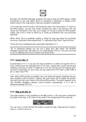
... make the track log visible on the map. There you have them reappear by a red dot and radiating red circles around it), or the current GPS position when it will automatically vanish back to another screen. 36 You can have a Master switch that screen.
... make the track log visible on the map. There you have them reappear by a red dot and radiating red circles around it), or the current GPS position when it will automatically vanish back to another screen. 36 You can have a Master switch that screen.


