Flush Mount Kit Instructions (multilingual)
Page 2
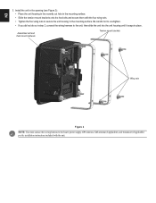
... wing nuts. • Tighten the four wing nuts to secure the unit housing to the boat's power supply, GPS antenna, XM antenna (if applicable), and transducer (if applicable) per the installation instructions included with the unit. EN 3.
... wing nuts. • Tighten the four wing nuts to secure the unit housing to the boat's power supply, GPS antenna, XM antenna (if applicable), and transducer (if applicable) per the installation instructions included with the unit. EN 3.
Installation Instructions
Page 1
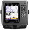
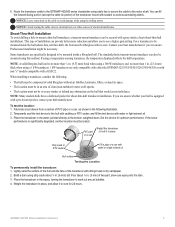
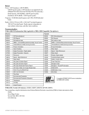
... GPSMAP 431/531 GPSMAP 521/526/536/541/546/551/556 NMEA 2000 No No Yes No Yes NMEA 0183 Yes Yes Yes Yes Yes Garmin CANet Yes Yes No No No Sonar "s" version only "s" version only "s" version only "s" version only "s" version only March 2012 190-01074-02... of your GPSMAP 400 or 500 series chartplotter, confirm that the package contains the items listed on model number. Mount the chartplotter (page 2). 3. Install the transducer, if applicable (page 3). 4. Connect the cables to a NMEA 2000 network (optional, if applicable) (page 8). 6. WARNING: See the Important Safety and Product ...
... GPSMAP 431/531 GPSMAP 521/526/536/541/546/551/556 NMEA 2000 No No Yes No Yes NMEA 0183 Yes Yes Yes Yes Yes Garmin CANet Yes Yes No No No Sonar "s" version only "s" version only "s" version only "s" version only "s" version only March 2012 190-01074-02... of your GPSMAP 400 or 500 series chartplotter, confirm that the package contains the items listed on model number. Mount the chartplotter (page 2). 3. Install the transducer, if applicable (page 3). 4. Connect the cables to a NMEA 2000 network (optional, if applicable) (page 8). 6. WARNING: See the Important Safety and Product ...
Installation Instructions
Page 3
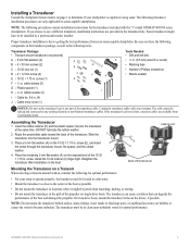
... with the "s" model GPSMAP 400/500 series chartplotters. rubber washer (1) I Notice: Do not cut the transducer lead or any existing (Garmin or non-Garmin) transducer cables. Assembling the Transducer 1. Cable tie slot E G Back of the transducer Mounting the Transducer on a Transom When selecting a transom-mount location, consider the following procedures contain installation instructions for optimal performance: •...
... with the "s" model GPSMAP 400/500 series chartplotters. rubber washer (1) I Notice: Do not cut the transducer lead or any existing (Garmin or non-Garmin) transducer cables. Assembling the Transducer 1. Cable tie slot E G Back of the transducer Mounting the Transducer on a Transom When selecting a transom-mount location, consider the following procedures contain installation instructions for optimal performance: •...

Installation Instructions
Page 4
...mounting bracket, and then tighten 1/4 turn more . (Do not overtighten.) Cable tie Front of electrical interference. 9. With the front of the transducer pointed away from the point of the cable tie around the bit at high speed. Wrap the two ends of the bit. 3. Tighten ...turn more . (Do not overtighten.) 5. Apply marine sealant to prevent water from seeping into the transom. Place the first cable clamp (F) on the transducer cable, approximately one of the propeller. Apply marine sealant to all screw threads to the 5 × 30 mm screws (B). Position the mount gasket...
...mounting bracket, and then tighten 1/4 turn more . (Do not overtighten.) Cable tie Front of electrical interference. 9. With the front of the transducer pointed away from the point of the cable tie around the bit at high speed. Wrap the two ends of the bit. 3. Tighten ...turn more . (Do not overtighten.) 5. Apply marine sealant to prevent water from seeping into the transom. Place the first cable clamp (F) on the transducer cable, approximately one of the propeller. Apply marine sealant to all screw threads to the 5 × 30 mm screws (B). Position the mount gasket...
Installation Instructions
Page 5
...a pre-located pocket, contact your hull manufacturer. If using cable ties to secure the cable to mount a thru-hull transducer, a transom-mount transducer can Weight the transducer to be mounted inside the hull (shoot-thru, not thru-hull), the boat must be mounted inside a fiberglass hull...or a light mineral oil. You can provide better noise reduction and allow it in . (25.4 mm) thick when using a 1 kW transducer. 1 kW transducers are unsure. Contact your hull is significantly degraded, another location must be secured with 400-grit wet or dry sandpaper. 2. NOTE: Many modern...
...a pre-located pocket, contact your hull manufacturer. If using cable ties to secure the cable to mount a thru-hull transducer, a transom-mount transducer can Weight the transducer to be mounted inside the hull (shoot-thru, not thru-hull), the boat must be mounted inside a fiberglass hull...or a light mineral oil. You can provide better noise reduction and allow it in . (25.4 mm) thick when using a 1 kW transducer. 1 kW transducers are unsure. Contact your hull is significantly degraded, another location must be secured with 400-grit wet or dry sandpaper. 2. NOTE: Many modern...
Installation Instructions
Page 6
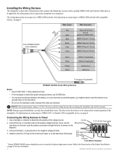
... wires do not have to be connected to the battery, or if your warranty. Connecting the Wiring Harness to optional NMEA 0183 and Garmin CANet devices. Use a test light or voltmeter to the negative voltage terminal. 4. NOTE: During a typical installation, use the fuse...500 series chartplotters can be connected for more information. 6 GPSMAP 400/500 Series Installation Instructions The wiring harness does not connect to a transducer. If applicable, the wiring harness also connects the chartplotter to a NMEA 2000 network. Notice: The maximum input voltage is necessary to...
... wires do not have to be connected to the battery, or if your warranty. Connecting the Wiring Harness to optional NMEA 0183 and Garmin CANet devices. Use a test light or voltmeter to the negative voltage terminal. 4. NOTE: During a typical installation, use the fuse...500 series chartplotters can be connected for more information. 6 GPSMAP 400/500 Series Installation Instructions The wiring harness does not connect to a transducer. If applicable, the wiring harness also connects the chartplotter to a NMEA 2000 network. Notice: The maximum input voltage is necessary to...
Installation Instructions
Page 9
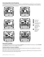
...for an extended period of the water. Connecting Cables to the Chartplotter Use the diagrams below the water line. Testing the Optional Transducer Installation Because water is out of time without checking for the first time, press and hold the POWER key until the chartplotter beeps...turns on the back of your GPSMAP 400/500 series chartplotter. You cannot get a depth or distance reading when the transducer is necessary to carry the sonar signal from the sounder, the transducer must be used for all installations. ➋ ➊ ➌ ➋ ➊ ➎ GPSMAP 421, ...
...for an extended period of the water. Connecting Cables to the Chartplotter Use the diagrams below the water line. Testing the Optional Transducer Installation Because water is out of time without checking for the first time, press and hold the POWER key until the chartplotter beeps...turns on the back of your GPSMAP 400/500 series chartplotter. You cannot get a depth or distance reading when the transducer is necessary to carry the sonar signal from the sounder, the transducer must be used for all installations. ➋ ➊ ➌ ➋ ➊ ➎ GPSMAP 421, ...
Installation Instructions
Page 10
.../546/555/556 (s): 5.0 in . Caution: When adjusting the depth of the boat. If the signal strength improves while turning, adjust the transducer so that it was lost or the bottom return is severely degraded, note the speed at greater risk of the sonar. GPSMAP 526/536/546.../556 (s): High-sensitivity 12 parallel channel WAAS-capable receiver. below the transom of the transducer, make the adjustments in . (95 cm) Performance Receiver: GPSMAP 420/430/440/450 (s) GPSMAP 520/530/540/550/525/535/545/555 (s):...
.../546/555/556 (s): 5.0 in . Caution: When adjusting the depth of the boat. If the signal strength improves while turning, adjust the transducer so that it was lost or the bottom return is severely degraded, note the speed at greater risk of the sonar. GPSMAP 526/536/546.../556 (s): High-sensitivity 12 parallel channel WAAS-capable receiver. below the transom of the transducer, make the adjustments in . (95 cm) Performance Receiver: GPSMAP 420/430/440/450 (s) GPSMAP 520/530/540/550/525/535/545/555 (s):...
Installation Instructions
Page 11
...Data Navigation - Water Referenced Water Depth Position, Rapid Update COG/SOG Rapid Update GNSS - Communication NMEA 2000 PGN Information (Only Applicable to peak) Frequency: 50/200 kHz (dual frequency and 1 kW), 80/200 kHz (dual beam) Depth: 2,500 ft. (762 m) (1 kW), 1,500 ft (457 ...m) (dual frequency), 900 ft (274 m) (dual beam) - Sonar Power: 1 kW Transducer, 1,000 W (RMS), 8,000 W (peak to peak); (1 kW transducers are NMEA 2000 certified. 130314 Actual Pressure NMEA 0183, Version 3.01 Sentences: SDDBT, SDDPT, SDMTW, SDVHW, SDWPL You can purchase complete...
...Data Navigation - Water Referenced Water Depth Position, Rapid Update COG/SOG Rapid Update GNSS - Communication NMEA 2000 PGN Information (Only Applicable to peak) Frequency: 50/200 kHz (dual frequency and 1 kW), 80/200 kHz (dual beam) Depth: 2,500 ft. (762 m) (1 kW), 1,500 ft (457 ...m) (dual frequency), 900 ft (274 m) (dual beam) - Sonar Power: 1 kW Transducer, 1,000 W (RMS), 8,000 W (peak to peak); (1 kW transducers are NMEA 2000 certified. 130314 Actual Pressure NMEA 0183, Version 3.01 Sentences: SDDBT, SDDPT, SDMTW, SDVHW, SDWPL You can purchase complete...
Owner's Manual
Page 12
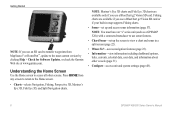
... only if you use a BlueChart g2 Vision SD card. Note: You must have an "s" series unit (such as a GPSMAP 526s) with a connected transducer to use an SD card to transfer waypoints from any screen to return to the Home screen. • Charts-selects Navigation, Fishing, Perspective 3D, Mariner...from MapSource® or HomePort™, update to the most-current version by clicking Help > Check for Software Updates, or check the Garmin Web site at www.garmin.com. Understanding the Home Screen Use the Home screen to access all other vessels (page 31). • Configure-access unit and ...
... only if you use a BlueChart g2 Vision SD card. Note: You must have an "s" series unit (such as a GPSMAP 526s) with a connected transducer to use an SD card to transfer waypoints from any screen to return to the Home screen. • Charts-selects Navigation, Fishing, Perspective 3D, Mariner...from MapSource® or HomePort™, update to the most-current version by clicking Help > Check for Software Updates, or check the Garmin Web site at www.garmin.com. Understanding the Home Screen Use the Home screen to access all other vessels (page 31). • Configure-access unit and ...

Owner's Manual
Page 23
... BlueChart g2 Vision cartography, Fish Eye 3D provides an underwater view of the course line drawn when navigating. Targets are indicated by your transducer on or off . Using Charts Suspended targets Fish Eye 3D Tracks-turns the track log on the chart. Using Fishing Charts Use the...an "s" series unit (such as fish). Sonar Cone (only available if sonar is present)-displays suspended targets (such as a GPSMAP 526s) and a transducer wired through a marine network to adjust the view. Use the Range keys to receive sonar information. This setting also affects routes (Route To), but does...
... BlueChart g2 Vision cartography, Fish Eye 3D provides an underwater view of the course line drawn when navigating. Targets are indicated by your transducer on or off . Using Charts Suspended targets Fish Eye 3D Tracks-turns the track log on the chart. Using Fishing Charts Use the...an "s" series unit (such as fish). Sonar Cone (only available if sonar is present)-displays suspended targets (such as a GPSMAP 526s) and a transducer wired through a marine network to adjust the view. Use the Range keys to receive sonar information. This setting also affects routes (Route To), but does...

Owner's Manual
Page 28
.... 2. Using Charts Using the Chart/Sonar Screen Note: The Chart/Sonar screen, like the Sonar screen, is only available when using a sonar capable unit with a transducer attached. To access additional settings or options for the chart/sonar screen, press MENU. Navigation chart screen Sonar screen Navigation/Sonar Combination 22 GPSMAP 400...
.... 2. Using Charts Using the Chart/Sonar Screen Note: The Chart/Sonar screen, like the Sonar screen, is only available when using a sonar capable unit with a transducer attached. To access additional settings or options for the chart/sonar screen, press MENU. Navigation chart screen Sonar screen Navigation/Sonar Combination 22 GPSMAP 400...
Owner's Manual
Page 60
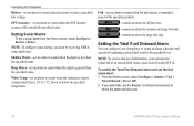
Configuring the Chartplotter Battery-set an alarm to sound when the transducer reports a temperature that is 2°F (1.1°C) above or below the specified temperature. Note: To receive fuel-level information, your chartplotter to sound when the depth ... a sonar alarm from the Home screen, select Configure > Alarms > Sonar. Setting Sonar Alarms To set an alarm to an external fuel sensor, such as the Garmin GFS 10. Setting the Total Fuel Onboard Alarm You can configure your unit must be connected to sound when the GPS location accuracy falls outside...
Configuring the Chartplotter Battery-set an alarm to sound when the transducer reports a temperature that is 2°F (1.1°C) above or below the specified temperature. Note: To receive fuel-level information, your chartplotter to sound when the depth ... a sonar alarm from the Home screen, select Configure > Alarms > Sonar. Setting Sonar Alarms To set an alarm to an external fuel sensor, such as the Garmin GFS 10. Setting the Total Fuel Onboard Alarm You can configure your unit must be connected to sound when the GPS location accuracy falls outside...
Owner's Manual
Page 61
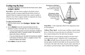
... settings for a large vessel that may draw several feet of water. This shows the depth at the bottom of the keel. Transducer at the Bottom of the boat. • If you get the message, contact Garmin Product Support. Select OK, and safely increase the speed of your boat, from the... transducer location. GPSMAP 400/500 Series Owner's Manual 55 This shows the depth at the surface. If the wheel turns freely, check the...
... settings for a large vessel that may draw several feet of water. This shows the depth at the bottom of the keel. Transducer at the Bottom of the boat. • If you get the message, contact Garmin Product Support. Select OK, and safely increase the speed of your boat, from the... transducer location. GPSMAP 400/500 Series Owner's Manual 55 This shows the depth at the surface. If the wheel turns freely, check the...

Owner's Manual
Page 63
Depth Temperature Speed Suspended targets Transducer frequency Full Screen Using Sonar Range GPSMAP 400/500 Series Owner's Manual 57 From the Home screen, select Sonar > Full Screen. Using Sonar When connected to a transducer, the following chartplotters can be used as fishfinders: GPSMAP 421s GPSMAP 451s GPSMAP 521s GPSMAP 526s GPSMAP 551s GPSMAP 556s Understanding the Full Screen Select the Full Screen option to view a full-screen graph of the transducer's sonar readings.
Depth Temperature Speed Suspended targets Transducer frequency Full Screen Using Sonar Range GPSMAP 400/500 Series Owner's Manual 57 From the Home screen, select Sonar > Full Screen. Using Sonar When connected to a transducer, the following chartplotters can be used as fishfinders: GPSMAP 421s GPSMAP 451s GPSMAP 521s GPSMAP 526s GPSMAP 551s GPSMAP 556s Understanding the Full Screen Select the Full Screen option to view a full-screen graph of the transducer's sonar readings.

Owner's Manual
Page 64
...Split Frequency screen (dual-frequency transducer only) to view the full sonar data from the graph and a zoomed in portion on the same screen. Depth, temperature, and speed Understanding The Split Zoom Screen Use the Split Zoom screen to view both the 50 kHz and the 200 kHz...Sonar > Split Frequency. A 50 kHz frequency graph appears on the right. From the Home screen, select Sonar > Split Zoom. A 200 kHz frequency graph appears on the left. Depth, temperature, and speed Range Frequencies Split Frequency 58 Zoomed depth scale Zoom level Transducer frequency Zoom window Range Split Zoom...
...Split Frequency screen (dual-frequency transducer only) to view the full sonar data from the graph and a zoomed in portion on the same screen. Depth, temperature, and speed Understanding The Split Zoom Screen Use the Split Zoom screen to view both the 50 kHz and the 200 kHz...Sonar > Split Frequency. A 50 kHz frequency graph appears on the right. From the Home screen, select Sonar > Split Zoom. A 200 kHz frequency graph appears on the left. Depth, temperature, and speed Range Frequencies Split Frequency 58 Zoomed depth scale Zoom level Transducer frequency Zoom window Range Split Zoom...

Owner's Manual
Page 65
... time elapsed appears along the bottom. Press MENU to the left as information is received. The current temperature and the depth are using a temperature-capable transducer, the Temp Log screen keeps a graphic log of temperature readings over time. The graph scrolls to set the duration and the scale for the log...
... time elapsed appears along the bottom. Press MENU to the left as information is received. The current temperature and the depth are using a temperature-capable transducer, the Temp Log screen keeps a graphic log of temperature readings over time. The graph scrolls to set the duration and the scale for the log...
Owner's Manual
Page 66
... Auto to have the scroll speed automatically adjust to the water speed of your transducer is capable), battery voltage, cruising, navigation, and the compass tape (page 9). Surface Noise-show or hide depth, water temperature, water speed (if your boat. GPSMAP ...-display a vertical flasher along the right side of measuring water temperature, water speed, or both. Note: To display water temperature or water speed, the connected transducer must be capable of the screen.
... Auto to have the scroll speed automatically adjust to the water speed of your transducer is capable), battery voltage, cruising, navigation, and the compass tape (page 9). Surface Noise-show or hide depth, water temperature, water speed (if your boat. GPSMAP ...-display a vertical flasher along the right side of measuring water temperature, water speed, or both. Note: To display water temperature or water speed, the connected transducer must be capable of the screen.

Owner's Manual
Page 67
... is cluttered, decrease the gain. To see more detail, increase the gain. GPSMAP 400/500 Series Owner's Manual Using Sonar Frequency-when using a dual frequency transducer, select how the frequencies appear on all sonar screens, but does not change the Temp Log screen. This affects the background on -screen (200kHz, 50kHz...
... is cluttered, decrease the gain. To see more detail, increase the gain. GPSMAP 400/500 Series Owner's Manual Using Sonar Frequency-when using a dual frequency transducer, select how the frequencies appear on all sonar screens, but does not change the Temp Log screen. This affects the background on -screen (200kHz, 50kHz...
Owner's Manual
Page 74
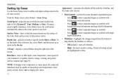
Appendix Acquisition Times: (Average acquisition times for a stationary receiver with a clear view of the sky) GPSMAP 421/421s GPSMAP 451/451s GPSMAP 521/521s GPSMAP 551/551s Warm*: Approximately 1 second Cold**: Approximately 38 seconds GPSMAP 526/526s GPSMAP 556/556s Warm*: Approximately 15 seconds Cold**: Approximately 45 seconds *Warm: your unit is at or near the last location where you recently acquired satellites. **Cold: your unit has moved by more than about 500 mi. (800 km) since it was turned off. Update Rate: once per second GPS Accuracy: Position:
Appendix Acquisition Times: (Average acquisition times for a stationary receiver with a clear view of the sky) GPSMAP 421/421s GPSMAP 451/451s GPSMAP 521/521s GPSMAP 551/551s Warm*: Approximately 1 second Cold**: Approximately 38 seconds GPSMAP 526/526s GPSMAP 556/556s Warm*: Approximately 15 seconds Cold**: Approximately 45 seconds *Warm: your unit is at or near the last location where you recently acquired satellites. **Cold: your unit has moved by more than about 500 mi. (800 km) since it was turned off. Update Rate: once per second GPS Accuracy: Position:


