Owner's Manual
Page 3
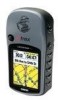
...without the symbol to alert you for using both the eTrex Legend Cx and the Venture Cx and is provided at the end for your new navigation system, take time to create an unsurpassed portable GPS receiver. If pieces are not included with the only ...Appendix contains information, such as specifications, optional accessories, and maintenance. eTrex Venture Cx and Legend Cx Owner's Manual INTRODUCTION > ABOUT THIS MANUAL The Getting Started section provides an overview of Garmin GPS and fullfeatured mapping to read this manual and learn the operating procedures for ...
...without the symbol to alert you for using both the eTrex Legend Cx and the Venture Cx and is provided at the end for your new navigation system, take time to create an unsurpassed portable GPS receiver. If pieces are not included with the only ...Appendix contains information, such as specifications, optional accessories, and maintenance. eTrex Venture Cx and Legend Cx Owner's Manual INTRODUCTION > ABOUT THIS MANUAL The Getting Started section provides an overview of Garmin GPS and fullfeatured mapping to read this manual and learn the operating procedures for ...
Owner's Manual
Page 4
... i About This Manual i Manual Conventions i Software License Agreement v Product Registration v Contact Garmin v Caring for you eTrex vi Cleaning the Case vi Cleaning the Screen vi Storage vi Water Immersion vi Warning vii ... Started 1 Unit Overview 1 Installing the Batteries 2 Key Functions 3 Turning on the eTrex 4 Adjusting the Backlight 4 Initializing the GPS Receiver 5 Using the eTrex 6 Understanding Terms 6 Selecting Options and Entering Data 7 ii The Status Bar and ... Finding an Address 23 Finding an Intersection 24 eTrex Venture Cx and Legend Cx Owner's Manual
... i About This Manual i Manual Conventions i Software License Agreement v Product Registration v Contact Garmin v Caring for you eTrex vi Cleaning the Case vi Cleaning the Screen vi Storage vi Water Immersion vi Warning vii ... Started 1 Unit Overview 1 Installing the Batteries 2 Key Functions 3 Turning on the eTrex 4 Adjusting the Backlight 4 Initializing the GPS Receiver 5 Using the eTrex 6 Understanding Terms 6 Selecting Options and Entering Data 7 ii The Status Bar and ... Finding an Address 23 Finding an Intersection 24 eTrex Venture Cx and Legend Cx Owner's Manual
Owner's Manual
Page 10
...responsible for any fines, penalties, or damages that is either not available or prohibitively expensive. viii eTrex Venture Cx and Legend Cx Owner's Manual INTRODUCTION > CAUTION Caution Failure to avoid the following potentially hazardous situations may be misused or ... This product should be used . The Global Positioning System (GPS) is operated by the United States government, which is a precision navigation device, any navigation device can be incurred as a navigational aid. Garmin does not take any responsibility for aircraft navigation. The government's...
...responsible for any fines, penalties, or damages that is either not available or prohibitively expensive. viii eTrex Venture Cx and Legend Cx Owner's Manual INTRODUCTION > CAUTION Caution Failure to avoid the following potentially hazardous situations may be misused or ... This product should be used . The Global Positioning System (GPS) is operated by the United States government, which is a precision navigation device, any navigation device can be incurred as a navigational aid. Garmin does not take any responsibility for aircraft navigation. The government's...
Owner's Manual
Page 11
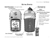
GETTING STARTED Unit Overview (eTrex Legend Cx shown) GPS antenna • Provides quick satellite acquisition Legend Cx GETTING STARTED > UNIT OVERVIEW USB connector port (under weather cap) Battery compartment cover Belt Clip/Auxiliary Mount Adapter attachment location • Accepts a Belt Clip accessory ... Mount Adapter accessory supplied with the unit. (Refer to page 72 for accessory listings.) Color LCD display Battery compartment locking D-Ring Carry Lanyard attachment slots eTrex Venture Cx and Legend Cx Owner's Manual 1
GETTING STARTED Unit Overview (eTrex Legend Cx shown) GPS antenna • Provides quick satellite acquisition Legend Cx GETTING STARTED > UNIT OVERVIEW USB connector port (under weather cap) Battery compartment cover Belt Clip/Auxiliary Mount Adapter attachment location • Accepts a Belt Clip accessory ... Mount Adapter accessory supplied with the unit. (Refer to page 72 for accessory listings.) Color LCD display Battery compartment locking D-Ring Carry Lanyard attachment slots eTrex Venture Cx and Legend Cx Owner's Manual 1
Owner's Manual
Page 15
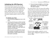
... a satellite fix, a list of each overhead satellite is a location 45 degrees from the horizon. eTrex Venture Cx and Legend Cx Owner's Manual GETTING STARTED > INITIALIZING THE GPS RECEIVER 3. Initializing the GPS Receiver The first time you turn on your eTrex, the GPS receiver must be outdoors and have a clear view of the sky. Press and hold the...
... a satellite fix, a list of each overhead satellite is a location 45 degrees from the horizon. eTrex Venture Cx and Legend Cx Owner's Manual GETTING STARTED > INITIALIZING THE GPS RECEIVER 3. Initializing the GPS Receiver The first time you turn on your eTrex, the GPS receiver must be outdoors and have a clear view of the sky. Press and hold the...
Owner's Manual
Page 20
... waypoints using the Find Menu, and how to create a new waypoint. To accept the waypoint with your eTrex, including creating and using waypoints, using three methods. eTrex Venture Cx and Legend Cx Owner's Manual Press and hold the MARK key until the Mark Waypoint Page appears. After entering and con&#... on the Mark Waypoint Page, highlight the appropriate field, and press Enter to mark your current location. 10 To mark your GPS. Creating and Using Waypoints Waypoints are assigned to the selected waypoint. You can add waypoints to routes and even create a Go To ...
... waypoints using the Find Menu, and how to create a new waypoint. To accept the waypoint with your eTrex, including creating and using waypoints, using three methods. eTrex Venture Cx and Legend Cx Owner's Manual Press and hold the MARK key until the Mark Waypoint Page appears. After entering and con&#... on the Mark Waypoint Page, highlight the appropriate field, and press Enter to mark your current location. 10 To mark your GPS. Creating and Using Waypoints Waypoints are assigned to the selected waypoint. You can add waypoints to routes and even create a Go To ...
Owner's Manual
Page 23
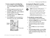
...Enter to open the Average Location Page. Select the waypoint for that specific location. Original location New location Moving a waypoint eTrex Venture Cx and Legend Cx Owner's Manual BASIC OPERATION > CREATING AND USING WAYPOINTS Averaging the Waypoint's Location You can average a waypoint's location. Press the ...it has been saved to a new location on the Map Page: 1. To calculate the average location: 1. NOTE: You must have a GPS satellite fix before you want to move the waypoint to the waypoints list and the Mark Waypoint page is closed as there is no ...
...Enter to open the Average Location Page. Select the waypoint for that specific location. Original location New location Moving a waypoint eTrex Venture Cx and Legend Cx Owner's Manual BASIC OPERATION > CREATING AND USING WAYPOINTS Averaging the Waypoint's Location You can average a waypoint's location. Press the ...it has been saved to a new location on the Map Page: 1. To calculate the average location: 1. NOTE: You must have a GPS satellite fix before you want to move the waypoint to the waypoints list and the Mark Waypoint page is closed as there is no ...
Owner's Manual
Page 33
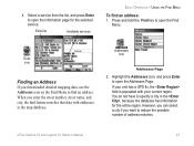
...When you downloaded detailed mapping data, use the Addresses icon on the Find Menu to open the information page for the entire region. eTrex Venture Cx and Legend Cx Owner's Manual 23 Exits icon Finding an Address If you enter the street number, street name, and city, the find ...feature matches that data with your unit has a GPS fix, the field is populated with addresses in the , because the database has information for...
...When you downloaded detailed mapping data, use the Addresses icon on the Find Menu to open the information page for the entire region. eTrex Venture Cx and Legend Cx Owner's Manual 23 Exits icon Finding an Address If you enter the street number, street name, and city, the find ...feature matches that data with your unit has a GPS fix, the field is populated with addresses in the , because the database has information for...
Owner's Manual
Page 34
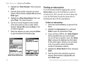
...BASIC OPERATION > USING THE FIND MENU 3. Select the address you downloaded detailed mapping data, use the Intersections icon on -screen keypad. eTrex Venture Cx and Legend Cx Owner's Manual When finished, highlight OK, and press Enter again. You do not have to reduce the possible number of intersection ...if you enter two street names and a city, the Find feature locates the intersection by matching that data with your unit has a GPS fix, the field is populated with the map database. Highlight the Intersections icon, and press Enter to search for the entire ...
...BASIC OPERATION > USING THE FIND MENU 3. Select the address you downloaded detailed mapping data, use the Intersections icon on -screen keypad. eTrex Venture Cx and Legend Cx Owner's Manual When finished, highlight OK, and press Enter again. You do not have to reduce the possible number of intersection ...if you enter two street names and a city, the Find feature locates the intersection by matching that data with your unit has a GPS fix, the field is populated with the map database. Highlight the Intersections icon, and press Enter to search for the entire ...
Owner's Manual
Page 37
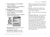
... of the active track on the data card are .gpx GPS position data files, and are not used by advanced GPS users with new data. • Record Method-Distance records track points after a specified time has elapsed. eTrex Venture Cx and Legend Cx Owner's Manual BASIC OPERATION > USING TRACKS Time creates track points...
... of the active track on the data card are .gpx GPS position data files, and are not used by advanced GPS users with new data. • Record Method-Distance records track points after a specified time has elapsed. eTrex Venture Cx and Legend Cx Owner's Manual BASIC OPERATION > USING TRACKS Time creates track points...
Owner's Manual
Page 48
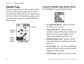
...signals from the Main Menu thereafter. Satellite location Location Satellite signal strength Satellite Page • Use With GPS Off/On-enables you to open the Options Menu. The Satellite Page appears when you are having trouble locking onto ... color. • New Location-use if you have moved the unit more than 600 miles and you turn the GPS receiver on and is accessed from at least three satellites. Using the Satellite Page Options Menu Press the Menu key... with North toward the top of the display or your current elevation. 38 eTrex Venture Cx and Legend Cx Owner's Manual
...signals from the Main Menu thereafter. Satellite location Location Satellite signal strength Satellite Page • Use With GPS Off/On-enables you to open the Options Menu. The Satellite Page appears when you are having trouble locking onto ... color. • New Location-use if you have moved the unit more than 600 miles and you turn the GPS receiver on and is accessed from at least three satellites. Using the Satellite Page Options Menu Press the Menu key... with North toward the top of the display or your current elevation. 38 eTrex Venture Cx and Legend Cx Owner's Manual
Owner's Manual
Page 67
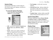
...the System Setup Page to control settings for day or night viewing. Display Setup Use the Display Setup Page to select a screen color scheme for GPS, WAAS, battery type, language, external power and proximity alarms. To access the System Setup Page: On the Setup Menu Page, highlight the System... mode, Battery Saver mode, GPS Off, or Demo Mode. • WAAS-allows you to enable or disable the Wide Area Augmentation System (page 77). • Battery Type-allows you to select the battery type you are on (Stay On) or turns off . eTrex Venture Cx and Legend Cx Owner's Manual MAIN MENU >...
...the System Setup Page to control settings for day or night viewing. Display Setup Use the Display Setup Page to select a screen color scheme for GPS, WAAS, battery type, language, external power and proximity alarms. To access the System Setup Page: On the Setup Menu Page, highlight the System... mode, Battery Saver mode, GPS Off, or Demo Mode. • WAAS-allows you to enable or disable the Wide Area Augmentation System (page 77). • Battery Type-allows you to select the battery type you are on (Stay On) or turns off . eTrex Venture Cx and Legend Cx Owner's Manual MAIN MENU >...
Owner's Manual
Page 78
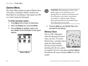
Press the Quit key, and highlight Yes, when prompted to view the symbol. 68 eTrex Venture Cx and Legend Cx Owner's Manual Travel to each game appears. Select the Games icon, and press Enter. 3. Press Menu twice to highlight a game, and press Enter. ... Nibbons, Gekoids, and Beast Hunt) for entertainment. To select and play . Memory Race This is a GPS virtual game where the playing piece moves where you are moving on a real playing field), use GPS as holes, obstructions, or proximity to vehicular traffic. A brief description of the two-symbol sets together...
Press the Quit key, and highlight Yes, when prompted to view the symbol. 68 eTrex Venture Cx and Legend Cx Owner's Manual Travel to each game appears. Select the Games icon, and press Enter. 3. Press Menu twice to highlight a game, and press Enter. ... Nibbons, Gekoids, and Beast Hunt) for entertainment. To select and play . Memory Race This is a GPS virtual game where the playing piece moves where you are moving on a real playing field), use GPS as holes, obstructions, or proximity to vehicular traffic. A brief description of the two-symbol sets together...

Owner's Manual
Page 79
Highlight Re-Center and press Enter to place yourself back in custom mode: 1. Virtua Maze This GPS game creates a virtual maze on the screen. The difficulty level determines how much of the maze you can see at a central position in ... must explore the maze collecting flags. GekoSmak GekoSmak is a GPS-based game that features you how many flags remain. Field size choices are : Easy, Normal, and Hard. The pace quickens and values vary as the player piece. eTrex Venture Cx and Legend Cx Owner's Manual 69 The lower right corner of the screen...
Highlight Re-Center and press Enter to place yourself back in custom mode: 1. Virtua Maze This GPS game creates a virtual maze on the screen. The difficulty level determines how much of the maze you can see at a central position in ... must explore the maze collecting flags. GekoSmak GekoSmak is a GPS-based game that features you how many flags remain. Field size choices are : Easy, Normal, and Hard. The pace quickens and values vary as the player piece. eTrex Venture Cx and Legend Cx Owner's Manual 69 The lower right corner of the screen...

Owner's Manual
Page 80
..., and blast away. 70 eTrex Venture Cx and Legend Cx Owner's Manual Your ship always points up . Press Enter to make your ship in the center of the map. As an added challenge, you must walk around your tail, or you lose a life. MAIN MENU > GAMES MENU Nibbons In this GPS game, you walk, your...
..., and blast away. 70 eTrex Venture Cx and Legend Cx Owner's Manual Your ship always points up . Press Enter to make your ship in the center of the map. As an added challenge, you must walk around your tail, or you lose a life. MAIN MENU > GAMES MENU Nibbons In this GPS game, you walk, your...

Owner's Manual
Page 81
...the Visibility Menu. Select a difficulty level (Trainee, Beginner, Expert, or Master), and press Enter to place an arrow in which you diagonally. eTrex Venture Cx and Legend Cx Owner's Manual MAIN MENU > GAMES MENU 3. To defeat the dragon, press Enter to open the Difficulty Level Menu. When you land on... slides, and warning platforms. A scoreboard keeps track of several difficulty levels and an extended or limited visibility option. Beast Hunt Although not a true GPS game, Beast Hunt requires some navigation skills, in a shaded platform. When you lose. 5.
...the Visibility Menu. Select a difficulty level (Trainee, Beginner, Expert, or Master), and press Enter to place an arrow in which you diagonally. eTrex Venture Cx and Legend Cx Owner's Manual MAIN MENU > GAMES MENU 3. To defeat the dragon, press Enter to open the Difficulty Level Menu. When you land on... slides, and warning platforms. A scoreboard keeps track of several difficulty levels and an extended or limited visibility option. Beast Hunt Although not a true GPS game, Beast Hunt requires some navigation skills, in a shaded platform. When you lose. 5.
Owner's Manual
Page 82
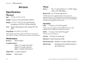
...: 5.6 ounces (159 g) with batteries installed. Display:1.3" W x 1.7" H, 256-color, high resolution, transreflective TFT(176 x 220 pixels) Backlit. Use Lithium batteries when operating the Legend Cx or Venture Cx in patch Power Source: Two 1.5 volt AA batteries, 12 -volt DC Adapter Cable, or PC/USB Adapter Battery Life: Up to 70oC)* *The temperature...
...: 5.6 ounces (159 g) with batteries installed. Display:1.3" W x 1.7" H, 256-color, high resolution, transreflective TFT(176 x 220 pixels) Backlit. Use Lithium batteries when operating the Legend Cx or Venture Cx in patch Power Source: Two 1.5 volt AA batteries, 12 -volt DC Adapter Cable, or PC/USB Adapter Battery Life: Up to 70oC)* *The temperature...
Owner's Manual
Page 84
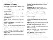
... the next point on a route. Maximum-the maximum speed you have attained since the trip computer was reset. 74 eTrex Venture Cx and Legend Cx Owner's Manual Bearing-the compass direction from your present position and elevation to travel as latitude and longitude coordinates. At ... DATA FIELD DEFINITIONS Data Field Definitions The following list provides a brief definition of your GPSdetermined location. Accuracy Of GPS-the current accuracy of each data field option. Distance - Location (selected)-your current vehicle speed measured in the selected units ...
... the next point on a route. Maximum-the maximum speed you have attained since the trip computer was reset. 74 eTrex Venture Cx and Legend Cx Owner's Manual Bearing-the compass direction from your present position and elevation to travel as latitude and longitude coordinates. At ... DATA FIELD DEFINITIONS Data Field Definitions The following list provides a brief definition of your GPSdetermined location. Accuracy Of GPS-the current accuracy of each data field option. Distance - Location (selected)-your current vehicle speed measured in the selected units ...

Owner's Manual
Page 87
... the best accuracy. WAAS and EGNOS are just two service providers that monitor GPS satellite data. WAAS is the European version of the GPS signal for global satellite based eTrex Venture Cx and Legend Cx Owner's Manual APPENDIX > WHAT IS WAAS/EGNOS? According to the MOPS (Minimum... accuracy, even when receiving signals from the reference stations and create a GPS data correction message. Master stations, located on your eTrex in the same manner. Currently, enabling WAAS on your Garmin GPS receiver, the receiver automatically uses the method that are to less than that...
... the best accuracy. WAAS and EGNOS are just two service providers that monitor GPS satellite data. WAAS is the European version of the GPS signal for global satellite based eTrex Venture Cx and Legend Cx Owner's Manual APPENDIX > WHAT IS WAAS/EGNOS? According to the MOPS (Minimum... accuracy, even when receiving signals from the reference stations and create a GPS data correction message. Master stations, located on your eTrex in the same manner. Currently, enabling WAAS on your Garmin GPS receiver, the receiver automatically uses the method that are to less than that...

Owner's Manual
Page 88
...Garmin units. You can be carried out in a consistent and accurate manner. Every chart has a map datum 78 reference and the eTrex can also select one of those commonly used by a framework of ground monuments whose positions have been accurately measured and calculated on a mathematical model of coordinates. eTrex Venture Cx and Legend Cx...UPS (Universal Transverse Mercator/Universal Polar Stereographic) projection formats are easy-to-use different location formats, Garmin GPS units allow you to choose the correct coordinate system for the advanced user). The most common format ...
...Garmin units. You can be carried out in a consistent and accurate manner. Every chart has a map datum 78 reference and the eTrex can also select one of those commonly used by a framework of ground monuments whose positions have been accurately measured and calculated on a mathematical model of coordinates. eTrex Venture Cx and Legend Cx...UPS (Universal Transverse Mercator/Universal Polar Stereographic) projection formats are easy-to-use different location formats, Garmin GPS units allow you to choose the correct coordinate system for the advanced user). The most common format ...


