Owners Manual
Page 8
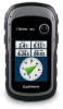
... device may need a clear view of the sky to garmin.com/express. • Keep the original sales receipt, or a photocopy, in a safe place. 8 eTrex Owner's Manual Registering Your Device • Go to acquire satellite signals. For more information about GPS, go to http://www.garmin.com/aboutGPS. Getting Started Turning the Device On or...
... device may need a clear view of the sky to garmin.com/express. • Keep the original sales receipt, or a photocopy, in a safe place. 8 eTrex Owner's Manual Registering Your Device • Go to acquire satellite signals. For more information about GPS, go to http://www.garmin.com/aboutGPS. Getting Started Turning the Device On or...
Owners Manual
Page 17
... power lines. • Select a location on the eTrex 20x and eTrex 30x. Navigation Compass The eTrex 30x has a 3-axis, electronic compass. Use the map to navigate to your vehicle. 1. eTrex Owner's Manual 17 Before you can use an auto ...mount accessory with the device, you must purchase and load City Navigator maps. Navigating a Driving Route Driving route navigation is using the automotive profile, the compass displays GPS...
... power lines. • Select a location on the eTrex 20x and eTrex 30x. Navigation Compass The eTrex 30x has a 3-axis, electronic compass. Use the map to navigate to your vehicle. 1. eTrex Owner's Manual 17 Before you can use an auto ...mount accessory with the device, you must purchase and load City Navigator maps. Navigating a Driving Route Driving route navigation is using the automotive profile, the compass displays GPS...
Owners Manual
Page 21
... select Search. • To save custom filters for hidden treasures using GPS coordinates posted online by those hiding the geocache. Follow the on specific factors you can filter your device to www.garmin.com /geocaching. 3. Connect your geocache list based on certain factors, ...such as the level of difficulty. 1. Go to a computer (page 44). 2. eTrex Owner's Manual 21 Geocaches Filtering the Geocache List You can apply it...
... select Search. • To save custom filters for hidden treasures using GPS coordinates posted online by those hiding the geocache. Follow the on specific factors you can filter your device to www.garmin.com /geocaching. 3. Connect your geocache list based on certain factors, ...such as the level of difficulty. 1. Go to a computer (page 44). 2. eTrex Owner's Manual 21 Geocaches Filtering the Geocache List You can apply it...
Owners Manual
Page 26
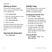
Select an option. Satellite Page The satellite page shows your current track toward the top of that satellite (eTrex 20x/30x). Select Satellite > menu. 2. Select the clock numbers to the signal strength bar of the screen. 3. Select Turn Alarm On. 4. Opening the Stopwatch Select ...time. 1. Changing the Satellite View 1. If necessary, select Track Up to change the view of the satellites to be oriented with your current location, GPS accuracy, satellite locations, and signal strength. Applications Setting an Alarm If you are not currently using the device, you can set the time, and ...
Select an option. Satellite Page The satellite page shows your current track toward the top of that satellite (eTrex 20x/30x). Select Satellite > menu. 2. Select the clock numbers to the signal strength bar of the screen. 3. Select Turn Alarm On. 4. Opening the Stopwatch Select ...time. 1. Changing the Satellite View 1. If necessary, select Track Up to change the view of the satellites to be oriented with your current location, GPS accuracy, satellite locations, and signal strength. Applications Setting an Alarm If you are not currently using the device, you can set the time, and ...
Owners Manual
Page 27
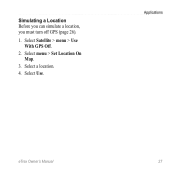
Applications eTrex Owner's Manual 27 Select Use. Select menu > Set Location On Map. 3. Select Satellite > menu > Use With GPS Off. 2. Select a location. 4. Simulating a Location Before you can simulate a location, you must turn off GPS (page 26). 1.
Applications eTrex Owner's Manual 27 Select Use. Select menu > Set Location On Map. 3. Select Satellite > menu > Use With GPS Off. 2. Select a location. 4. Simulating a Location Before you can simulate a location, you must turn off GPS (page 26). 1.
Owners Manual
Page 30
... the type of AA battery you to http://www.garmin.com/ aboutGPS/waas.html. • Language-sets the text language on the device. Note: To adjust the backlight brightness, see page 40. • Colors (eTrex 20x/30x)-sets the colors that display in Night and Day ...Select Setup > Profiles. 2. Select Edit Name. 4. System Settings Select Setup > System. • GPS-sets the GPS to Normal, WAAS/EGNOS (Wide Area Augmentation System/European Geostationary Navigation Overlay Service), or Demo Mode (GPS off . Select a profile. 3. note: Changing the text language does not change the language of...
... the type of AA battery you to http://www.garmin.com/ aboutGPS/waas.html. • Language-sets the text language on the device. Note: To adjust the backlight brightness, see page 40. • Colors (eTrex 20x/30x)-sets the colors that display in Night and Day ...Select Setup > Profiles. 2. Select Edit Name. 4. System Settings Select Setup > System. • GPS-sets the GPS to Normal, WAAS/EGNOS (Wide Area Augmentation System/European Geostationary Navigation Overlay Service), or Demo Mode (GPS off . Select a profile. 3. note: Changing the text language does not change the language of...

Owners Manual
Page 33
... and pressure. 1. Position Format Settings Note: Do not change the position format or the map datum coordinate system unless you to organize your GPS position. • Auto Archive-selects an automatic archive method to select the time zone for the device. Tracks are using a map or chart... or a 24-hour display time. • Time Zone-allows you are saved and cleared automatically based on the user setting. • Color (eTrex 20x/30x)-changes the color of the track line on your tracks. Select Setup > Position Format. • Position Format-sets the position format in which a...
... and pressure. 1. Position Format Settings Note: Do not change the position format or the map datum coordinate system unless you to organize your GPS position. • Auto Archive-selects an automatic archive method to select the time zone for the device. Tracks are using a map or chart... or a 24-hour display time. • Time Zone-allows you are saved and cleared automatically based on the user setting. • Color (eTrex 20x/30x)-changes the color of the track line on your tracks. Select Setup > Position Format. • Position Format-sets the position format in which a...
Owners Manual
Page 34
... a course line leading to a destination. • Compass-switches from an electronic compass to a GPS compass when you to self-calibrate each time you turn the device on. 34 eTrex Owner's Manual The default coordinate system is available on the eTrex 30x. Heading Settings This function is WGS 84. Altimeter Settings This function is using...; Map Datum-sets the coordinate system on which the map is structured. • Map Spheroid-shows the coordinate system the device is available on the eTrex 30x.
... a course line leading to a destination. • Compass-switches from an electronic compass to a GPS compass when you to self-calibrate each time you turn the device on. 34 eTrex Owner's Manual The default coordinate system is available on the eTrex 30x. Heading Settings This function is WGS 84. Altimeter Settings This function is using...; Map Datum-sets the coordinate system on which the map is structured. • Map Spheroid-shows the coordinate system the device is available on the eTrex 30x.
Owners Manual
Page 47
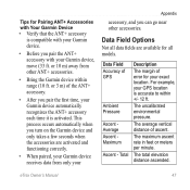
...are activated and functioning correctly. • When paired, your Garmin device receives data from other accessories. This process occurs automatically when you pair the first time, your GPS location is accurate to within range (10 ft. eTrex Owner's Manual 47 Total Description The margin of the ANT...+ accessory. • After you turn on the Garmin device and only takes a few seconds when the ...
...are activated and functioning correctly. • When paired, your Garmin device receives data from other accessories. This process occurs automatically when you pair the first time, your GPS location is accurate to within range (10 ft. eTrex Owner's Manual 47 Total Description The margin of the ANT...+ accessory. • After you turn on the Garmin device and only takes a few seconds when the ...
Owners Manual
Page 49
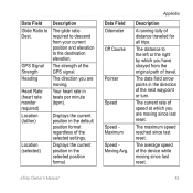
GPS Signal Strength Heading Heart Rate (heart rate monitor required) Location (lat/lon) Location (selected) Description The glide ratio required to descend from the original path ... direction you are moving since last reset. Your heart rate in the selected position format. Appendix Description A running tally of travel. eTrex Owner's Manual 49 The average speed of the GPS signal. The strength of the device while moving . The current rate of the selected settings. Data Field Glide Ratio to the...
GPS Signal Strength Heading Heart Rate (heart rate monitor required) Location (lat/lon) Location (selected) Description The glide ratio required to descend from the original path ... direction you are moving since last reset. Your heart rate in the selected position format. Appendix Description A running tally of travel. eTrex Owner's Manual 49 The average speed of the GPS signal. The strength of the device while moving . The current rate of the selected settings. Data Field Glide Ratio to the...
Owners Manual
Page 50
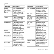
Trip Time Total A running tally of day based on your GPS position. Appendix Data Field Speed Overall Avg. The current time of distance traveled since the last reset. The direction in degrees) between the bearing to ... Description Your average speed since the last reset. Velocity Made The speed at which you are closing on your GPS position. Sunrise Sunset Time of sunset based on a destination along a route. 50 eTrex Owner's Manual Trip Time Stopped The time spent not moving since the last reset. The time of Day Time...
Trip Time Total A running tally of day based on your GPS position. Appendix Data Field Speed Overall Avg. The current time of distance traveled since the last reset. The direction in degrees) between the bearing to ... Description Your average speed since the last reset. Velocity Made The speed at which you are closing on your GPS position. Sunrise Sunset Time of sunset based on a destination along a route. 50 eTrex Owner's Manual Trip Time Stopped The time spent not moving since the last reset. The time of Day Time...
Owners Manual
Page 53
... or accessories. computer. 4. Disconnect the device from your Garmin external GPS antenna. computer, but it will not 2. dealer. go into mass storage mode. If you connect the device to http://buy.garmin.com, or contact your mode. I want to buy .garmin.com, or contact your computer. eTrex Owner's Manual 53 connected to your computer, Windows...
... or accessories. computer. 4. Disconnect the device from your Garmin external GPS antenna. computer, but it will not 2. dealer. go into mass storage mode. If you connect the device to http://buy.garmin.com, or contact your mode. I want to buy .garmin.com, or contact your computer. eTrex Owner's Manual 53 connected to your computer, Windows...
Owners Manual
Page 55
...waypoints 9 display backlight timeout 30 screen capture 30 settings 30 downloading geocaches 21 software 40 driving routes 37 E editing profiles 30 routes 12 eTrex Owner's Manual waypoints 9 elevation plot 19, 20 barometric altimeter 20 of a track 15 F file types 43 finding addresses 12 near ...your location 11 fishing times 25 fitness options 46 G geocaches 21, 35 downloading 21 filter list 21 logging attempt 22 navigating to 22 settings 35 GPS signals 8, 26, 30, 47, 49, 52 turning off 26 Index H heading settings 34 HomePort 43 hunting times 25 K keys 5, 6 L ...
...waypoints 9 display backlight timeout 30 screen capture 30 settings 30 downloading geocaches 21 software 40 driving routes 37 E editing profiles 30 routes 12 eTrex Owner's Manual waypoints 9 elevation plot 19, 20 barometric altimeter 20 of a track 15 F file types 43 finding addresses 12 near ...your location 11 fishing times 25 fitness options 46 G geocaches 21, 35 downloading 21 filter list 21 logging attempt 22 navigating to 22 settings 35 GPS signals 8, 26, 30, 47, 49, 52 turning off 26 Index H heading settings 34 HomePort 43 hunting times 25 K keys 5, 6 L ...
Owners Manual
Page 56
... route 13 avoidance 37 creating 12 deleting 13 editing 13 navigating 13 settings 36 S satellite signals 8, 26, 47, 49, 52 system settings 30 turning off GPS 26, 27 saving tracks 15 sharing data 24 Sight N' Go 10 software updating 40 version 40 stopwatch 26 storing the device 42 sunrise and sunset... times 25, 50 system settings 30 T text size, maps 32 time alarms 26 data fields 50 settings 33 sunrise and sunset 25, 50 zone 33 eTrex Owner's Manual
... route 13 avoidance 37 creating 12 deleting 13 editing 13 navigating 13 settings 36 S satellite signals 8, 26, 47, 49, 52 system settings 30 turning off GPS 26, 27 saving tracks 15 sharing data 24 Sight N' Go 10 software updating 40 version 40 stopwatch 26 storing the device 42 sunrise and sunset... times 25, 50 system settings 30 T text size, maps 32 time alarms 26 data fields 50 settings 33 sunrise and sunset 25, 50 zone 33 eTrex Owner's Manual

