

Owner's Manual
Page 3
...26 Customizing Your Device.....28 Customizing the Main Menu........28 Customizing Specific Pages........28 Profiles 29 System Settings 30 Display Settings 30 3 Menu 11 Routes 12 Tracks 14 Navigation 16 Navigating to a Destination..........16 Map 16 Compass 17 Elevation Plot...chirp 23 Applications 24 Sharing Data 24 Setting a Proximity Alarm 24 Calculating the Size of Contents Getting Started 5 Device Overview 5 Using the eTrex Keys 6 Battery Information 7 Turning the Device On or Off.........8 Satellite Signals 8 Registering Your Device 8 Waypoints, Routes, and Tracks 9 ...
...26 Customizing Your Device.....28 Customizing the Main Menu........28 Customizing Specific Pages........28 Profiles 29 System Settings 30 Display Settings 30 3 Menu 11 Routes 12 Tracks 14 Navigation 16 Navigating to a Destination..........16 Map 16 Compass 17 Elevation Plot...chirp 23 Applications 24 Sharing Data 24 Setting a Proximity Alarm 24 Calculating the Size of Contents Getting Started 5 Device Overview 5 Using the eTrex Keys 6 Battery Information 7 Turning the Device On or Off.........8 Satellite Signals 8 Registering Your Device 8 Waypoints, Routes, and Tracks 9 ...

Owner's Manual
Page 6
Press menu twice to access the main menu from any page. • Press ▲ and ▼ to display a list of the Thumb Stick to select the highlighted item. • Press back to move around the map. • Press the center of commonly-used ... Started ➏ ➐ ➑ ➒ ➏ Mini-USB port (under weather cap) ➐ Battery cover ➑ Battery cover locking ring ➒ Mounting spine Using the eTrex Keys • Move the Thumb Stick up, down, left, and right to highlight menu selections or to move back one step in the menu structure...
Press menu twice to access the main menu from any page. • Press ▲ and ▼ to display a list of the Thumb Stick to select the highlighted item. • Press back to move around the map. • Press the center of commonly-used ... Started ➏ ➐ ➑ ➒ ➏ Mini-USB port (under weather cap) ➐ Battery cover ➑ Battery cover locking ring ➒ Mounting spine Using the eTrex Keys • Move the Thumb Stick up, down, left, and right to highlight menu selections or to move back one step in the menu structure...

Owner's Manual
Page 17
...Automotive. 2. Navigation Compass The eTrex 30 has a 3-axis, electronic compass. TIP: When the device is only available on the map, and the bar at the top of the map. Navigating a Driving Route Driving route navigation is using the automotive profile, the compass displays GPS heading, not magnetic ...such as cars, buildings, or overhead power lines. Before you can use the map, you must purchase and load City Navigator maps. eTrex Owner's Manual 17 You can use a bearing pointer or a course pointer to navigate to the destination. 3. Calibrating the Compass Notice ...
...Automotive. 2. Navigation Compass The eTrex 30 has a 3-axis, electronic compass. TIP: When the device is only available on the map, and the bar at the top of the map. Navigating a Driving Route Driving route navigation is using the automotive profile, the compass displays GPS heading, not magnetic ...such as cars, buildings, or overhead power lines. Before you can use the map, you must purchase and load City Navigator maps. eTrex Owner's Manual 17 You can use a bearing pointer or a course pointer to navigate to the destination. 3. Calibrating the Compass Notice ...

Owner's Manual
Page 19
between dots on the eTrex 30. Use the course pointer to navigate to a destination (page 16). 2. To customize the elevation plot, see page 34. Select an option. Select Elevation Plot. eTrex Owner's Manual 19 Select Compass. 3. Select Elevation Plot > menu > Change Plot Type. 2. ...Viewing Details about the point appear at the top of the plot. By default, the elevation plot displays the elevation for an elapsed time. ...
between dots on the eTrex 30. Use the course pointer to navigate to a destination (page 16). 2. To customize the elevation plot, see page 34. Select an option. Select Elevation Plot. eTrex Owner's Manual 19 Select Compass. 3. Select Elevation Plot > menu > Change Plot Type. 2. ...Viewing Details about the point appear at the top of the plot. By default, the elevation plot displays the elevation for an elapsed time. ...

Owner's Manual
Page 20
.... 2. Follow the on-screen instructions. Select Elevation Plot > menu > Calibrate Altimeter. 3. Select Trip Computer > menu > Reset > Reset Trip Data > Yes. Trip Computer The trip computer displays your current speed, average speed, maximum speed, trip odometer, and other helpful statistics. Go to zero. To customize the trip computer, see page 28. 20...
.... 2. Follow the on-screen instructions. Select Elevation Plot > menu > Calibrate Altimeter. 3. Select Trip Computer > menu > Reset > Reset Trip Data > Yes. Trip Computer The trip computer displays your current speed, average speed, maximum speed, trip odometer, and other helpful statistics. Go to zero. To customize the trip computer, see page 28. 20...
Owner's Manual
Page 28
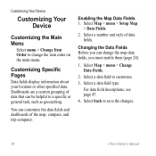
...Menu Select menu > Change Item Order to change the map data fields, you must enable them (page 28). 1. Customizing Specific Pages Data fields display information about your location or other specified data. For data field descriptions, see page 47. 4. Select back to customize. 3. Select a number and... a custom grouping of data fields. You can change the item order on the main menu. Select a data field to save the changes. 28 eTrex Owner's Manual Select Map > menu > Setup Map > Data Fields. 2. Changing the Data Fields Before you can customize the data fields and dashboards...
...Menu Select menu > Change Item Order to change the map data fields, you must enable them (page 28). 1. Customizing Specific Pages Data fields display information about your location or other specified data. For data field descriptions, see page 47. 4. Select back to customize. 3. Select a number and... a custom grouping of data fields. You can change the item order on the main menu. Select a data field to save the changes. 28 eTrex Owner's Manual Select Map > menu > Setup Map > Data Fields. 2. Changing the Data Fields Before you can customize the data fields and dashboards...

Owner's Manual
Page 30
... 1. Note: To adjust the backlight brightness, see page 40. • Colors (eTrex 20/30)-sets the colors that display in Night and Day mode. ◦◦ Mode-sets a light background (Day), a dark background 30 eTrex Owner's Manual Select a profile. 3. System Settings Select Setup > System. •... GPS-sets the GPS to http://www.garmin.com/ aboutGPS/waas.html. • Language...
... 1. Note: To adjust the backlight brightness, see page 40. • Colors (eTrex 20/30)-sets the colors that display in Night and Day mode. ◦◦ Mode-sets a light background (Day), a dark background 30 eTrex Owner's Manual Select a profile. 3. System Settings Select Setup > System. •... GPS-sets the GPS to http://www.garmin.com/ aboutGPS/waas.html. • Language...
Owner's Manual
Page 32
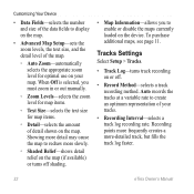
Showing more detail may cause the map to redraw more -detailed track, but fills the track log faster. 32 eTrex Owner's Manual Recording points more frequently creates a more slowly. ◦◦ Shaded Relief-shows detail relief on the map (if available) or turns off . • ...Record Method-selects a track recording method. Customizing Your Device • Data Fields-selects the number and size of the data fields to display on the map. • Advanced Map Setup-sets the zoom levels, the text size, and the detail level of the map. ◦◦ Auto Zoom...
Showing more detail may cause the map to redraw more -detailed track, but fills the track log faster. 32 eTrex Owner's Manual Recording points more frequently creates a more slowly. ◦◦ Shaded Relief-shows detail relief on the map (if available) or turns off . • ...Record Method-selects a track recording method. Customizing Your Device • Data Fields-selects the number and size of the data fields to display on the map. • Advanced Map Setup-sets the zoom levels, the text size, and the detail level of the map. ◦◦ Auto Zoom...

Owner's Manual
Page 33
Select Setup > Position Format. • Position Format-sets the position format in which a given location reading appears. eTrex Owner's Manual 33 Select Setup > Units. 2. Select a unit of the track line on your tracks. Tracks are using a map or chart that specifies a different... Setup > Time. • Time Format-allows you to select a 12-hour or a 24-hour display time. • Time Zone-allows you are saved and cleared automatically based on the user setting. • Color (eTrex 20/30)-changes the color of measure for the device. Position Format Settings Note: Do not change the...
Select Setup > Position Format. • Position Format-sets the position format in which a given location reading appears. eTrex Owner's Manual 33 Select Setup > Units. 2. Select a unit of the track line on your tracks. Tracks are using a map or chart that specifies a different... Setup > Time. • Time Format-allows you to select a 12-hour or a 24-hour display time. • Time Zone-allows you are saved and cleared automatically based on the user setting. • Color (eTrex 20/30)-changes the color of measure for the device. Position Format Settings Note: Do not change the...

Owner's Manual
Page 34
...turns the compass off. • Calibrate Compass-page 17. sets the direction to your destination. ◦◦ Course (CDI)-the course deviation indicator displays your relationship to a course line leading to a destination. • Compass-switches from an electronic compass to select how the course appears. ◦&#...higher rate of speed for a set period of the compass. • Go To Line (Pointer)-allows you turn the device on. 34 eTrex Owner's Manual Customizing Your Device • Map Datum-sets the coordinate system on which the map is structured. • Map Spheroid-shows ...
...turns the compass off. • Calibrate Compass-page 17. sets the direction to your destination. ◦◦ Course (CDI)-the course deviation indicator displays your relationship to a course line leading to a destination. • Compass-switches from an electronic compass to select how the course appears. ◦&#...higher rate of speed for a set period of the compass. • Go To Line (Pointer)-allows you turn the device on. 34 eTrex Owner's Manual Customizing Your Device • Map Datum-sets the coordinate system on which the map is structured. • Map Spheroid-shows ...

Owner's Manual
Page 35
... pressure should change only due to display the geocache list by names or codes. Geocaching Settings Select Setup > Geocaches. • Geocache List-allows you to weather. • Pressure Trending ◦◦ Save When Power On- records pressure data only when the device is turned on. eTrex Owner's Manual 35 Customizing Your Device...
... pressure should change only due to display the geocache list by names or codes. Geocaching Settings Select Setup > Geocaches. • Geocache List-allows you to weather. • Pressure Trending ◦◦ Save When Power On- records pressure data only when the device is turned on. eTrex Owner's Manual 35 Customizing Your Device...

Owner's Manual
Page 37
... The nautical chart reflects the drawing scheme of paper charts. ◦◦ Fishing-(requires marine maps) displays a detailed view of marine navigation aids on the eTrex 20 and eTrex 30. eTrex Owner's Manual 37 • Lock On Road-locks the position icon, which represents your position on ...Select Setup > Marine. • Marine Chart Mode-allows you to select a nautical chart or a fishing chart: ◦◦ Nautical-displays various map features in different colors so that the marine POIs are within a specified distance of your current point. • Avoidance Setup-(available...
... The nautical chart reflects the drawing scheme of paper charts. ◦◦ Fishing-(requires marine maps) displays a detailed view of marine navigation aids on the eTrex 20 and eTrex 30. eTrex Owner's Manual 37 • Lock On Road-locks the position icon, which represents your position on ...Select Setup > Marine. • Marine Chart Mode-allows you to select a nautical chart or a fishing chart: ◦◦ Nautical-displays various map features in different colors so that the marine POIs are within a specified distance of your current point. • Avoidance Setup-(available...
Owner's Manual
Page 40
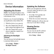
... unit ID, software version, and license agreement. Go to adjust the contrast level (eTrex 10 only). Viewing Device Information You can decrease the backlight timeout to adjust the brightness... level. 3. Move the Thumb Stick up and down to http://www.garmin.com /products/webupdater. 2. Extensive use of your computer (page 44). 1. note: Updating ... 1. Move the Thumb Stick left and right to maximize battery power. Select Setup > Display > Backlight Timeout. Device Information Device Information Adjusting the Screen Note: The backlight brightness may ...
... unit ID, software version, and license agreement. Go to adjust the contrast level (eTrex 10 only). Viewing Device Information You can decrease the backlight timeout to adjust the brightness... level. 3. Move the Thumb Stick up and down to http://www.garmin.com /products/webupdater. 2. Extensive use of your computer (page 44). 1. note: Updating ... 1. Move the Thumb Stick left and right to maximize battery power. Select Setup > Display > Backlight Timeout. Device Information Device Information Adjusting the Screen Note: The backlight brightness may ...
Owner's Manual
Page 49
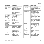
... format. Appendix Description A running tally of the GPS signal. The current rate of speed at which you are moving since last reset. Displays the current position in beats per minute (bpm). Data Field Odometer Off Course Pointer Speed Speed Maximum Speed Moving Avg.... eTrex Owner's Manual 49 The strength of distance traveled for all trips. Displays the current position in the direction of the device while moving since last reset. The distance to the destination...
... format. Appendix Description A running tally of the GPS signal. The current rate of speed at which you are moving since last reset. Displays the current position in beats per minute (bpm). Data Field Odometer Off Course Pointer Speed Speed Maximum Speed Moving Avg.... eTrex Owner's Manual 49 The strength of distance traveled for all trips. Displays the current position in the direction of the device while moving since last reset. The distance to the destination...

Owner's Manual
Page 55
... profiles 29 D data fields 28 options 47 deleting files 45 profiles 30 routes 13 tracks 15 waypoints 9 display backlight timeout 30 screen capture 30 settings 30 downloading geocaches 21 software 40 driving routes 37 E editing profiles 30 routes 12 waypoints 9 eTrex Owner's Manual elevation plot 19, 20 barometric altimeter 20 of a track 15 F file types 43 finding...
... profiles 29 D data fields 28 options 47 deleting files 45 profiles 30 routes 13 tracks 15 waypoints 9 display backlight timeout 30 screen capture 30 settings 30 downloading geocaches 21 software 40 driving routes 37 E editing profiles 30 routes 12 waypoints 9 eTrex Owner's Manual elevation plot 19, 20 barometric altimeter 20 of a track 15 F file types 43 finding...


