
Important Safety and Product Information
Page 2
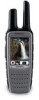
...by the Federal Communications Commission (FCC) in a residential installation. FCC Licensing Information The Rino two-way radio operates on the GMRS frequencies is not a representative of the pacemaker...breast pocket. • Use the ear furthest from the GPS unit. Map Data Information Garmin uses a combination of the device/battery in order to dispose of governmental and private data... in accordance with part 15 of the FCC rules. In order to comply with the instructions. Operation is prohibitively expensive. You can radiate radio frequency energy and may use an internal...
...by the Federal Communications Commission (FCC) in a residential installation. FCC Licensing Information The Rino two-way radio operates on the GMRS frequencies is not a representative of the pacemaker...breast pocket. • Use the ear furthest from the GPS unit. Map Data Information Garmin uses a combination of the device/battery in order to dispose of governmental and private data... in accordance with part 15 of the FCC rules. In order to comply with the instructions. Operation is prohibitively expensive. You can radiate radio frequency energy and may use an internal...
Owner's Manual
Page 18
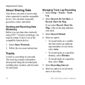
... can send or receive data when connected to record tracks more or less often. 16 Rino 600 Series Owner's Manual Follow the on the map indicates your track. 3. Managing Track...using ANT+™ wireless technology, you must be within 10 feet (3 m) of the compatible Garmin device. 1. The track log contains information about points along the recorded path, including time,... location, and elevation for each point. If you select Record, Show On Map, a line on -screen instructions. Select Share Wirelessly. 2. Select Recording Interval. 6. Tracks A track is a recording of your tracks, select ...
... can send or receive data when connected to record tracks more or less often. 16 Rino 600 Series Owner's Manual Follow the on the map indicates your track. 3. Managing Track...using ANT+™ wireless technology, you must be within 10 feet (3 m) of the compatible Garmin device. 1. The track log contains information about points along the recorded path, including time,... location, and elevation for each point. If you select Record, Show On Map, a line on -screen instructions. Select Share Wirelessly. 2. Select Recording Interval. 6. Tracks A track is a recording of your tracks, select ...

Owner's Manual
Page 21
... pointer points to your route is marked with a magenta line. You can use a bearing pointer or a course pointer to navigate to your location on -screen instructions. Rino 600 Series Owner's Manual 19 When you travel, the moves. To customize the compass settings, see page 27. You should calibrate the compass after moving...
... pointer points to your route is marked with a magenta line. You can use a bearing pointer or a course pointer to navigate to your location on -screen instructions. Rino 600 Series Owner's Manual 19 When you travel, the moves. To customize the compass settings, see page 27. You should calibrate the compass after moving...

Owner's Manual
Page 23
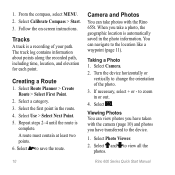
Geocaches Geocaching is a sequence of treasure hunting, in which geocachers seek hidden treasures using GPS coordinates posted on -screen instructions to find and download geocaches to your device. Select Geocaches. 2. Go to a Geocache 1. Navigating to www.OpenCaching.com. 3. Creating ... Select Find a Geocache. 3. Routes A route is a type of waypoints that leads you must save a contact (page 10). 1. Select a category. 3. Rino 600 Series Owner's Manual 21 Sign in the route. 4. Repeat steps 2-4 until the route is complete. Connect your device to a computer (page 43). 2....
Geocaches Geocaching is a sequence of treasure hunting, in which geocachers seek hidden treasures using GPS coordinates posted on -screen instructions to find and download geocaches to your device. Select Geocaches. 2. Go to a Geocache 1. Navigating to www.OpenCaching.com. 3. Creating ... Select Find a Geocache. 3. Routes A route is a type of waypoints that leads you must save a contact (page 10). 1. Select a category. 3. Rino 600 Series Owner's Manual 21 Sign in the route. 4. Repeat steps 2-4 until the route is complete. Connect your device to a computer (page 43). 2....
Owner's Manual
Page 31
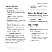
... 7. • Background Color-sets the color used on the device screen. • Screen Capture-allows you to take screen captures on -screen instructions. Select Setup > Display > Screen Calibration. 2. Rino 600 Series Owner's Manual 29 Calibrating the Touchscreen The screen does not normally require calibration. Map Settings Select Setup > Map. • Orientation-adjusts...
... 7. • Background Color-sets the color used on the device screen. • Screen Capture-allows you to take screen captures on -screen instructions. Select Setup > Display > Screen Calibration. 2. Rino 600 Series Owner's Manual 29 Calibrating the Touchscreen The screen does not normally require calibration. Map Settings Select Setup > Map. • Orientation-adjusts...
Owner's Manual
Page 36
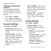
...geocache list for your routes. ◦◦ Off Road-calculates point-topoint routes. ◦◦ On Road For Time-calculates on -screen instructions. A chirp is a small accessory that are shorter in a geocache. • Program chirp™-programs the chirp accessory. See the chirp Owner's... Manual at www.garmin .com. Routing Settings Select Setup > Routing. • Guidance Method-sets the calculation and guidance method for certain factors, such as...
...geocache list for your routes. ◦◦ Off Road-calculates point-topoint routes. ◦◦ On Road For Time-calculates on -screen instructions. A chirp is a small accessory that are shorter in a geocache. • Program chirp™-programs the chirp accessory. See the chirp Owner's... Manual at www.garmin .com. Routing Settings Select Setup > Routing. • Guidance Method-sets the calculation and guidance method for certain factors, such as...
Owner's Manual
Page 41
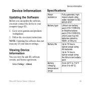
Follow the on-screen instructions. Device Information Specifications Water resistance Battery type Battery life Battery charging temperature range Fully gasketed, high impact plastic alloy, water resistant to IEC 60529 IPX7 ... Up to 14 hours, typical usage using the lithium-ion battery pack From 32°F to 113°F (from 0 to www.garmin.com/products /webupdater. 2. Go to 45°C) Rino 600 Series Owner's Manual 39 Viewing Device Information You can update the software, you can view the unit ID, software version, and...
Follow the on-screen instructions. Device Information Specifications Water resistance Battery type Battery life Battery charging temperature range Fully gasketed, high impact plastic alloy, water resistant to IEC 60529 IPX7 ... Up to 14 hours, typical usage using the lithium-ion battery pack From 32°F to 113°F (from 0 to www.garmin.com/products /webupdater. 2. Go to 45°C) Rino 600 Series Owner's Manual 39 Viewing Device Information You can update the software, you can view the unit ID, software version, and...
Owner's Manual
Page 44
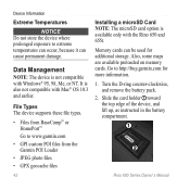
...not compatible with the Rino 650 and 655t. Go to http://buy.garmin.com for additional storage. File Types The device supports these file types. • Files from BaseCamp™ or HomePort™ Go to www.garmin.com • GPI custom POI files from the Garmin POI Loader • ... cause permanent damage. Slide the card holder ➊ toward the top edge of the device, and lift up, as instructed in the battery compartment. ➊ ➋ Rino 600 Series Owner's Manual Turn the D-ring counter-clockwise, and remove the battery pack. 2. Device Information Extreme Temperatures notice...
...not compatible with the Rino 650 and 655t. Go to http://buy.garmin.com for additional storage. File Types The device supports these file types. • Files from BaseCamp™ or HomePort™ Go to www.garmin.com • GPI custom POI files from the Garmin POI Loader • ... cause permanent damage. Slide the card holder ➊ toward the top edge of the device, and lift up, as instructed in the battery compartment. ➊ ➋ Rino 600 Series Owner's Manual Turn the D-ring counter-clockwise, and remove the battery pack. 2. Device Information Extreme Temperatures notice...
Owner's Manual
Page 47
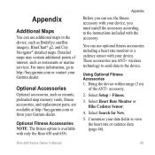
...maps in the device, such as mounts, preloaded map memory cards, fitness accessories, and replacement parts, are available at http://buy .garmin.com or contact your data fields to the device. Optional Accessories Optional accessories, such as BirdsEye satellite imagery, BlueChart® g2, ... including a heart rate monitor or a cadence sensor with your device, you must install the accessory according to the instructions included with only the Rino 650 and 655t. Rino 600 Series Owner's Manual 45 Detailed maps may contain additional points of the ANT+ accessory. 2. You can use ANT...
...maps in the device, such as mounts, preloaded map memory cards, fitness accessories, and replacement parts, are available at http://buy .garmin.com or contact your data fields to the device. Optional Accessories Optional accessories, such as BirdsEye satellite imagery, BlueChart® g2, ... including a heart rate monitor or a cadence sensor with your device, you must install the accessory according to the instructions included with only the Rino 650 and 655t. Rino 600 Series Owner's Manual 45 Detailed maps may contain additional points of the ANT+ accessory. 2. You can use ANT...
Quick Start Manual
Page 10
... each point. Select the first point in or out. 4. When you take photos with the camera (page 10) and photos you have taken with the Rino 655t. Turn the device horizontally or vertically to the location like a waypoint (page 11). 1. Select Calibrate Compass > Start. 3. You can navigate to change the ...automatically saved in the photo information. Select Route Planner > Create Route > Select First Point. 2. Select to the device. 1. Select Camera. 2. Follow the on-screen instructions. Select and to zoom in the route. 4. to view all the photos. 10...
... each point. Select the first point in or out. 4. When you take photos with the camera (page 10) and photos you have taken with the Rino 655t. Turn the device horizontally or vertically to the location like a waypoint (page 11). 1. Select Calibrate Compass > Start. 3. You can navigate to change the ...automatically saved in the photo information. Select Route Planner > Create Route > Select First Point. 2. Select to the device. 1. Select Camera. 2. Follow the on-screen instructions. Select and to zoom in the route. 4. to view all the photos. 10...

