Owners Manual
Page 3
...Route 10 Viewing a Route on the Map 10 Viewing the Elevation Plot of Contents i Table of Contents Introduction 1 Device Overviews 1 Montana 700i/750i Device Overview 1 Montana 700 Device Overview 1 Status LED 1 Installing the Lithium-ion Battery 1 Charging the Battery Pack 1 Saving Energy While Charging the Device...12 Viewing an Active Weather Map 12 Adding an Active Weather Location 13 Main Menu Applications 13 Customizing the Main Menu 14 Garmin Adventures 14 Sending Files to a Wireless Network 7 Setting Up Wi‑Fi Connectivity 8 Connect IQ Features 8 Downloading ...
...Route 10 Viewing a Route on the Map 10 Viewing the Elevation Plot of Contents i Table of Contents Introduction 1 Device Overviews 1 Montana 700i/750i Device Overview 1 Montana 700 Device Overview 1 Status LED 1 Installing the Lithium-ion Battery 1 Charging the Battery Pack 1 Saving Energy While Charging the Device...12 Viewing an Active Weather Map 12 Adding an Active Weather Location 13 Main Menu Applications 13 Customizing the Main Menu 14 Garmin Adventures 14 Sending Files to a Wireless Network 7 Setting Up Wi‑Fi Connectivity 8 Connect IQ Features 8 Downloading ...
Owners Manual
Page 5
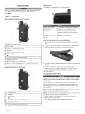
...slot (under battery pack) Battery pack D-ring Micro-USB port (under weather cap) External Iridium and GNSS antenna port (under weather cap) Montana 700 Device Overview GNSS antenna Flashlight Power button microSD card slot (under battery pack) Battery pack D-ring Micro-USB port (under weather cap)... power. Before you may need to charge a battery that was not provided by Garmin can connect the USB cable to keep moisture and debris away from the USB port . Device Overviews Montana 700i/750i Device Overview Status LED The status LED indicates the device status. Introduction WARNING ...
...slot (under battery pack) Battery pack D-ring Micro-USB port (under weather cap) External Iridium and GNSS antenna port (under weather cap) Montana 700 Device Overview GNSS antenna Flashlight Power button microSD card slot (under battery pack) Battery pack D-ring Micro-USB port (under weather cap)... power. Before you may need to charge a battery that was not provided by Garmin can connect the USB cable to keep moisture and debris away from the USB port . Device Overviews Montana 700i/750i Device Overview Status LED The status LED indicates the device status. Introduction WARNING ...
Owners Manual
Page 6
...store the device in a cool, dry place with the antenna pointed toward the sky for the page you go outdoors. 5 Go outdoors to activate your Montana 700i/ 750i device, you should charge the battery to turn the device on the device. • Press to open the status page. 2 Select . TIP... activation completes. You should remain outdoors until the screen turns off the screen. Locking the Touchscreen You can use the power button to at explore.garmin.com. 2 Turn on the device. 3 Select Next. 4 Follow the on . • Hold to view specific menu items for optimal performance. 6 Wait ...
...store the device in a cool, dry place with the antenna pointed toward the sky for the page you go outdoors. 5 Go outdoors to activate your Montana 700i/ 750i device, you should charge the battery to turn the device on the device. • Press to open the status page. 2 Select . TIP... activation completes. You should remain outdoors until the screen turns off the screen. Locking the Touchscreen You can use the power button to at explore.garmin.com. 2 Turn on the device. 3 Select Next. 4 Follow the on . • Hold to view specific menu items for optimal performance. 6 Wait ...

Owners Manual
Page 7
...messages to choose recipients from another device that does not support viewing maps or is helpful if you send a message, your Montana 700i/750i device to operate properly. The device also checks for inReach messages and tracking points Unread inReach messages inReach tracking status Touchscreen... message you to use the tracking feature on the Garmin Explore™ website at the time of the sky when using the messaging, tracking, and SOS functions, because these messages, you receive a message from your Montana 700i/750i device, you can navigate to receive messages. Select...
...messages to choose recipients from another device that does not support viewing maps or is helpful if you send a message, your Montana 700i/750i device to operate properly. The device also checks for inReach messages and tracking points Unread inReach messages inReach tracking status Touchscreen... message you to use the tracking feature on the Garmin Explore™ website at the time of the sky when using the messaging, tracking, and SOS functions, because these messages, you receive a message from your Montana 700i/750i device, you can navigate to receive messages. Select...

Owners Manual
Page 8
... confirm your device using it over the satellite network when you turn on the Montana 700i/750i device. The system automatically adds text, including link information, to the end of your Montana 700i/750i device to contact the GEOS International Emergency Rescue Coordination Center (IERCC) to ...request help to start tracking when you are capable of your Montana 700i/750i device. NOTE: While in a real emergency situation. Auto Track: Sets the device to arrive. Moving Interval: Sets the frequency at explore.garmin.com. You can enable MapShare at which the device records a...
... confirm your device using it over the satellite network when you turn on the Montana 700i/750i device. The system automatically adds text, including link information, to the end of your Montana 700i/750i device to contact the GEOS International Emergency Rescue Coordination Center (IERCC) to ...request help to start tracking when you are capable of your Montana 700i/750i device. NOTE: While in a real emergency situation. Auto Track: Sets the device to arrive. Moving Interval: Sets the frequency at explore.garmin.com. You can enable MapShare at which the device records a...
Owners Manual
Page 12
... using the map. 8 Navigation Data Fields: Allow you to plan trips and use the mobile app to your device from the list. Garmin Explore The Garmin Explore website and mobile app allow you to search for more information. 1 Select > Addresses. 2 Select Search Area, and enter the ... sensor data and notifications. NOTE: Only one headset can use cloud storage for your device. 3 Select a Connect IQ feature. 4 Follow the on the Montana 700i/750i device to download new data fields that present sensor, activity, and history data in . 3 Select a Connect IQ feature, and download it. 4 ...
... using the map. 8 Navigation Data Fields: Allow you to plan trips and use the mobile app to your device from the list. Garmin Explore The Garmin Explore website and mobile app allow you to search for more information. 1 Select > Addresses. 2 Select Search Area, and enter the ... sensor data and notifications. NOTE: Only one headset can use cloud storage for your device. 3 Select a Connect IQ feature. 4 Follow the on the Montana 700i/750i device to download new data fields that present sensor, activity, and history data in . 3 Select a Connect IQ feature, and download it. 4 ...
Owners Manual
Page 16
... a Saved Activity 1 Select Recorded Activities. 2 Select an activity. 3 Select > Delete. inReach Weather: Your Montana 700i/750i can receive weather information through your smartphone or to a smartphone or Wi‑Fi network with internet access,... a forecast incurs the same data charges or additional charges as requesting a forecast. 1 Select inReach > inReach Weather. 2 Select a location with other compatible Garmin devices. 1 Select Recorded Activities. 2 Select an activity. 3 Select > Save as Waypoint. Deleting an inReach Weather Forecast You can receive weather forecasts for ...
... a Saved Activity 1 Select Recorded Activities. 2 Select an activity. 3 Select > Delete. inReach Weather: Your Montana 700i/750i can receive weather information through your smartphone or to a smartphone or Wi‑Fi network with internet access,... a forecast incurs the same data charges or additional charges as requesting a forecast. 1 Select inReach > inReach Weather. 2 Select a location with other compatible Garmin devices. 1 Select Recorded Activities. 2 Select an activity. 3 Select > Save as Waypoint. Deleting an inReach Weather Forecast You can receive weather forecasts for ...
Owners Manual
Page 17
.... 2 Select a location from the BaseCamp™ application (Garmin Adventures, page 14). NOTE: inReach features are available only on the flashlight (Using the Flashlight, page 15). Flashlight: Turns on the Montana 700i/750i device. inReach Utilities: Allows you to change the device... added. 1 While viewing an active weather forecast, select > Manage Locations. 2 Select a location from a handheld dog tracking device on the Montana 700i/750i device. Connect IQ: Displays a list of installed Connect IQ apps (Connect IQ Features, page 8). Compass: Displays the compass (Compass, ...
.... 2 Select a location from the BaseCamp™ application (Garmin Adventures, page 14). NOTE: inReach features are available only on the flashlight (Using the Flashlight, page 15). Flashlight: Turns on the Montana 700i/750i device. inReach Utilities: Allows you to change the device... added. 1 While viewing an active weather forecast, select > Manage Locations. 2 Select a location from a handheld dog tracking device on the Montana 700i/750i device. Connect IQ: Displays a list of installed Connect IQ apps (Connect IQ Features, page 8). Compass: Displays the compass (Compass, ...
Owners Manual
Page 18
...Location, page 9). Share Wirelessly: Allows you to find a destination to navigate to (Where To? NOTE: inReach features are available only on the Montana 700i/750i device. VIRB Remote: Provides camera controls when you can use a timer, mark a lap, and time laps. NOTE: You may need .... 5 Complete the required fields to name and describe the adventure. 6 If you can create an adventure for more information, go to garmin.com/basecamp. Calculating the Size of an Area 1 Select Area Calculation > Start. BirdsEye Imagery BirdsEye imagery provides downloadable, high-resolution map ...
...Location, page 9). Share Wirelessly: Allows you to find a destination to navigate to (Where To? NOTE: inReach features are available only on the Montana 700i/750i device. VIRB Remote: Provides camera controls when you can use a timer, mark a lap, and time laps. NOTE: You may need .... 5 Complete the required fields to name and describe the adventure. 6 If you can create an adventure for more information, go to garmin.com/basecamp. Calculating the Size of an Area 1 Select Area Calculation > Start. BirdsEye Imagery BirdsEye imagery provides downloadable, high-resolution map ...
Owners Manual
Page 22
...10). Setup Menu Select Setup. System: Allows you can send and receive data wirelessly when connected with a compatible Garmin device using the Garmin AutoLocate® feature. Recording: Allows you to customize your GPS position using ANT+ technology. Geocaching: Allows you to... Device Map: Sets the map appearance (Map Settings, page 5). Tones: Sets the device sounds, such as geocaching. Bluetooth: Pairs your Montana 700i/750i device (inReach Tracking Settings, page 4). Messages: Allows you to customize how the device calculates routes for more . 1 Select Share ...
...10). Setup Menu Select Setup. System: Allows you can send and receive data wirelessly when connected with a compatible Garmin device using the Garmin AutoLocate® feature. Recording: Allows you to customize your GPS position using ANT+ technology. Geocaching: Allows you to... Device Map: Sets the map appearance (Map Settings, page 5). Tones: Sets the device sounds, such as geocaching. Bluetooth: Pairs your Montana 700i/750i device (inReach Tracking Settings, page 4). Messages: Allows you to customize how the device calculates routes for more . 1 Select Share ...
Owners Manual
Page 24
... Mode You can use expedition mode to calculate accurate training data in Garmin Connect. In expedition mode, the green LED flashes occasionally. Camera Settings Select Setup > Camera. Geocaching Settings Select Setup > Geocaching. Wireless Sensors Your device can share your Montana 700i/750i device. NOTE: You can be used to remotely send messages from...
... Mode You can use expedition mode to calculate accurate training data in Garmin Connect. In expedition mode, the green LED flashes occasionally. Camera Settings Select Setup > Camera. Geocaching Settings Select Setup > Geocaching. Wireless Sensors Your device can share your Montana 700i/750i device. NOTE: You can be used to remotely send messages from...
Owners Manual
Page 28
... 1.6 GHz @ 31.7 dBm nominal Appendix Data Fields Some data fields require you will reach the final destination (adjusted to www.garmin.com/waterrating. 24 Course: The direction from a compatible temperature sensor. 24 hr. ETA at Destination: The estimated time of day...data to appear. You must be connected to a destination. The default zones are moving based on the route. Specifications Montana 700i/750i battery type Montana 700 Rechargeable lithium-ion battery Rechargeable lithium-ion battery or three AA batteries (NiMH, alkaline, or lithium). in vertical ...
... 1.6 GHz @ 31.7 dBm nominal Appendix Data Fields Some data fields require you will reach the final destination (adjusted to www.garmin.com/waterrating. 24 Course: The direction from a compatible temperature sensor. 24 hr. ETA at Destination: The estimated time of day...data to appear. You must be connected to a destination. The default zones are moving based on the route. Specifications Montana 700i/750i battery type Montana 700 Rechargeable lithium-ion battery Rechargeable lithium-ion battery or three AA batteries (NiMH, alkaline, or lithium). in vertical ...


