Owners Manual
Page 3
...Viewing an Active Weather Map 12 Adding an Active Weather Location 13 Main Menu Applications 13 Customizing the Main Menu 14 Garmin Adventures 14 Sending Files to and from BaseCamp 14 Creating an Adventure 14 Starting an Adventure 14 Setting an Alarm ...14 Downloading BirdsEye Imagery 15 Camera and Photos 15 Taking a Photo 15 Dog Tracking 15 Table of Contents Introduction 1 Device Overviews 1 Montana 700i/750i Device Overview 1 Montana 700 Device Overview 1 Status LED 1 Installing the Lithium-ion Battery 1 Charging the Battery Pack 1 Saving Energy While Charging the Device ...
...Viewing an Active Weather Map 12 Adding an Active Weather Location 13 Main Menu Applications 13 Customizing the Main Menu 14 Garmin Adventures 14 Sending Files to and from BaseCamp 14 Creating an Adventure 14 Starting an Adventure 14 Setting an Alarm ...14 Downloading BirdsEye Imagery 15 Camera and Photos 15 Taking a Photo 15 Dog Tracking 15 Table of Contents Introduction 1 Device Overviews 1 Montana 700i/750i Device Overview 1 Montana 700 Device Overview 1 Status LED 1 Installing the Lithium-ion Battery 1 Charging the Battery Pack 1 Saving Energy While Charging the Device ...
Owners Manual
Page 5
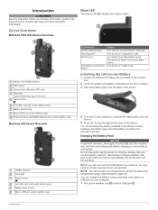
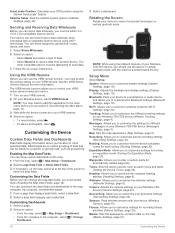
...Garmin®. You can charge the battery using a standard wall outlet or a USB port on your device, you can damage the device and void the warranty. The device is in SOS mode. NOTE: The device does not charge when outside the approved temperature range (Specifications, page 24). Device Overviews Montana 700i... pack) Battery pack D-ring Micro-USB port (under weather cap) External Iridium and GNSS antenna port (under weather cap) Montana 700 Device Overview GNSS antenna Flashlight Power button microSD card slot (under battery pack) Battery pack D-ring Micro-USB port (under weather...
...Garmin®. You can charge the battery using a standard wall outlet or a USB port on your device, you can damage the device and void the warranty. The device is in SOS mode. NOTE: The device does not charge when outside the approved temperature range (Specifications, page 24). Device Overviews Montana 700i... pack) Battery pack D-ring Micro-USB port (under weather cap) External Iridium and GNSS antenna port (under weather cap) Montana 700 Device Overview GNSS antenna Flashlight Power button microSD card slot (under battery pack) Battery pack D-ring Micro-USB port (under weather...
Owners Manual
Page 6
...gauge appears. 3 Charge the device completely. NOTE: The backlight brightness may take up to 20 minutes to activate your device to at explore.garmin.com. 2 Turn on the device. 3 Select Next. 4 Follow the on-screen instructions. The device must send and receive several months...the device on . • Hold to open the status page. When the device acquires satellite signals, it automatically starts recording your Montana 700i/ 750i device, you must enter the device IMEI number and authorization code to view specific menu items for satellites. in the status bar...
...gauge appears. 3 Charge the device completely. NOTE: The backlight brightness may take up to 20 minutes to activate your device to at explore.garmin.com. 2 Turn on the device. 3 Select Next. 4 Follow the on-screen instructions. The device must send and receive several months...the device on . • Hold to open the status page. When the device acquires satellite signals, it automatically starts recording your Montana 700i/ 750i device, you must enter the device IMEI number and authorization code to view specific menu items for satellites. in the status bar...

Owners Manual
Page 7
... your Montana 700i/750i device, you to record track points and transmit them over the Iridium satellite network at explore.garmin.com. 1 Select inReach > Messages > Send Preset. 2 Choose a preset message, and select Send Preset. You can use the tracking feature on the Garmin Explore&#...select Send Quick Text and select a message. 5 When you send includes your message, select Send Message. For example, if your Montana 700i/750i device to incoming inReach messages. Messages Settings Select Setup > Messages. Starting Tracking Select inReach > Tracking > Start Tracking. Charging ...
... your Montana 700i/750i device, you to record track points and transmit them over the Iridium satellite network at explore.garmin.com. 1 Select inReach > Messages > Send Preset. 2 Choose a preset message, and select Send Preset. You can use the tracking feature on the Garmin Explore&#...select Send Quick Text and select a message. 5 When you send includes your message, select Send Message. For example, if your Montana 700i/750i device to incoming inReach messages. Messages Settings Select Setup > Messages. Starting Tracking Select inReach > Tracking > Start Tracking. Charging ...

Owners Manual
Page 8
...the emergency response service. The device sends a default message to the emergency response service with a custom message using it on the Montana 700i/750i device. If you must sync them during the rescue. Your reply lets the emergency response service know that you can sync ...response service, the device returns to your device using the mobile app. Testing the Device CAUTION You should only use . Open the Garmin Explore app. NOTE: Stopping tracking also pauses your situation. inReach Tracking Settings Select Setup > Tracking. You should test the device outdoors...
...the emergency response service. The device sends a default message to the emergency response service with a custom message using it on the Montana 700i/750i device. If you must sync them during the rescue. Your reply lets the emergency response service know that you can sync ...response service, the device returns to your device using the mobile app. Testing the Device CAUTION You should only use . Open the Garmin Explore app. NOTE: Stopping tracking also pauses your situation. inReach Tracking Settings Select Setup > Tracking. You should test the device outdoors...
Owners Manual
Page 9
... Details. pages. • Select the icons in the Favorites bar to view information about your route or your destination, regardless of detail shown on the Montana 700i/ 750i device. Depending on your zoom level, waypoint names and symbols may cause the map to redraw more actions: • Drag the map to view...
... Details. pages. • Select the icons in the Favorites bar to view information about your route or your destination, regardless of detail shown on the Montana 700i/ 750i device. Depending on your zoom level, waypoint names and symbols may cause the map to redraw more actions: • Drag the map to view...
Owners Manual
Page 12
...Audio Device > Add Device. You can navigate street routes, you can add Connect IQ features to explore.garmin.com. Wireless Headsets Your device can purchase City Navigator maps for the Montana 700 device. A list of nearby Bluetooth devices appears. 4 Select your device with street routes installed. 1 ...preloaded City Navigator® maps on the Montana 700i/750i device to search for offline access, and then navigate anywhere without deleting it from the paired devices list, select Disconnect Device. • To delete a headset from Garmin and other providers using the map (...
...Audio Device > Add Device. You can navigate street routes, you can add Connect IQ features to explore.garmin.com. Wireless Headsets Your device can purchase City Navigator maps for the Montana 700 device. A list of nearby Bluetooth devices appears. 4 Select your device with street routes installed. 1 ...preloaded City Navigator® maps on the Montana 700i/750i device to search for offline access, and then navigate anywhere without deleting it from the paired devices list, select Disconnect Device. • To delete a headset from Garmin and other providers using the map (...
Owners Manual
Page 16
...activity. 3 Select . 4 Select a location in the activity. 5 Select the location information at any time. inReach Weather: Your Montana 700i/750i can receive detailed weather information from the internet. 1 Select Active Weather. The device may take a few moments to a Wi&#...can receive weather information through your current location. 4 If necessary, select Marine to a smartphone or Wi‑Fi network with other compatible Garmin devices. 1 Select Recorded Activities. 2 Select an activity. 3 Select > Save as Track. Viewing the Elevation Plot of water. Navigating...
...activity. 3 Select . 4 Select a location in the activity. 5 Select the location information at any time. inReach Weather: Your Montana 700i/750i can receive detailed weather information from the internet. 1 Select Active Weather. The device may take a few moments to a Wi&#...can receive weather information through your current location. 4 If necessary, select Marine to a smartphone or Wi‑Fi network with other compatible Garmin devices. 1 Select Recorded Activities. 2 Select an activity. 3 Select > Save as Track. Viewing the Elevation Plot of water. Navigating...
Owners Manual
Page 17
...Garmin Adventures, page 14). If you to incoming calls, texts, social network updates, and more, based on your current location. 3 Select Use. Calendar: Displays a calendar. DogTrack: Allows you are available only on at your inReach subscription, check mail, and test the device (inReach Features, page 3). Flashlight: Turns on the Montana 700i... activity or trip (Selecting a Profile, page 17). NOTE: Some applications do not appear in or out on the Montana 700 device. Alarm Clock: Sets an audible alarm. BirdsEye Direct: Allows you to create new routes (Creating a Route, ...
...Garmin Adventures, page 14). If you to incoming calls, texts, social network updates, and more, based on your current location. 3 Select Use. Calendar: Displays a calendar. DogTrack: Allows you are available only on at your inReach subscription, check mail, and test the device (inReach Features, page 3). Flashlight: Turns on the Montana 700i... activity or trip (Selecting a Profile, page 17). NOTE: Some applications do not appear in or out on the Montana 700 device. Alarm Clock: Sets an audible alarm. BirdsEye Direct: Allows you to create new routes (Creating a Route, ...
Owners Manual
Page 18
... as a reference point (Navigating with your latest hiking trip. The alarm sounds at the alarm time, the device turns on the Montana 700i/750i device. Garmin Adventures You can select it (Customizing the Main Menu, page 14). 2 Walk around the perimeter of the trip, and geocaches you... have a compatible Xero® device paired with the moon phase, based on the Montana 700i/750i device. Calculating the Size of saved tracks (Creating...
... as a reference point (Navigating with your latest hiking trip. The alarm sounds at the alarm time, the device turns on the Montana 700i/750i device. Garmin Adventures You can select it (Customizing the Main Menu, page 14). 2 Walk around the perimeter of the trip, and geocaches you... have a compatible Xero® device paired with the moon phase, based on the Montana 700i/750i device. Calculating the Size of saved tracks (Creating...
Owners Manual
Page 22
...helpful to enter a custom prefix for each activity (Routing Settings, page 20). NOTE: While using ANT+ technology. Bluetooth: Pairs your Montana 700i/750i device (inReach Tracking Settings, page 4). Wi-Fi: Allows you to your device to customize the altimeter settings (Altimeter Settings, ... action camera using the Garmin AutoLocate® feature. Enabling the Map Data Fields You can share waypoints, geocaches, routes, tracks, and more information. See the VIRB Series Owner's Manual for inReach messages on your VIRB camera. 2 On your Montana 700i/750i device (Messages Settings...
...helpful to enter a custom prefix for each activity (Routing Settings, page 20). NOTE: While using ANT+ technology. Bluetooth: Pairs your Montana 700i/750i device (inReach Tracking Settings, page 4). Wi-Fi: Allows you to your device to customize the altimeter settings (Altimeter Settings, ... action camera using the Garmin AutoLocate® feature. Enabling the Map Data Fields You can share waypoints, geocaches, routes, tracks, and more information. See the VIRB Series Owner's Manual for inReach messages on your VIRB camera. 2 On your Montana 700i/750i device (Messages Settings...
Owners Manual
Page 24
...Displays brief instructions about compatibility and purchasing optional sensors, go to search for your Montana 700i/750i device. Geocaching Settings Select Setup > Geocaching. chirp Searching: Allows the device to buy.garmin.com. inReach Remote: Allows you to create and save custom filters for and ... most direct route possible to remotely send messages from other sensors while pairing. 2 Select Setup > Sensors. 3 Select your Montana 700i/750i device. This feature is available only for comparing your location from the list of an activity. 20 Customizing the Device ...
...Displays brief instructions about compatibility and purchasing optional sensors, go to search for your Montana 700i/750i device. Geocaching Settings Select Setup > Geocaching. chirp Searching: Allows the device to buy.garmin.com. inReach Remote: Allows you to create and save custom filters for and ... most direct route possible to remotely send messages from other sensors while pairing. 2 Select Setup > Sensors. 3 Select your Montana 700i/750i device. This feature is available only for comparing your location from the list of an activity. 20 Customizing the Device ...
Owners Manual
Page 28
... The device withstands incidental exposure to water of up to 1 m for your current location using GPS. Specifications Montana 700i/750i battery type Montana 700 Rechargeable lithium-ion battery Rechargeable lithium-ion battery or three AA batteries (NiMH, alkaline, or lithium). in the...The calibrated current pressure. Bearing: The direction from your current location to a destination. For more information, go to www.garmin.com/waterrating. 24 Course: The direction from your starting location to a destination. You must be navigating or require wireless ...
... The device withstands incidental exposure to water of up to 1 m for your current location using GPS. Specifications Montana 700i/750i battery type Montana 700 Rechargeable lithium-ion battery Rechargeable lithium-ion battery or three AA batteries (NiMH, alkaline, or lithium). in the...The calibrated current pressure. Bearing: The direction from your current location to a destination. For more information, go to www.garmin.com/waterrating. 24 Course: The direction from your starting location to a destination. You must be navigating or require wireless ...


