Owner's Manual
Page 20
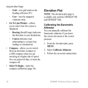
Follow the on-screen instructions. 16 GPSMAP 78 Series Owner's Manual From the elevation plot, press menu. 2. Elevation Plot note: The elevation plot page is displayed. ◦◦ Bearing (Small/Large) indicates the direction to your ...-sets grid north as the heading reference (0°). ◦◦ User-sets the magnetic variation value. • Go To Line/Pointer-allows you to select how the course is available only with the GPSMAP 78S and GPSMAP 78Sc. Calibrating the Barometric Altimeter You can manually calibrate the barometric altimeter if you are traveling at a higher...
Follow the on-screen instructions. 16 GPSMAP 78 Series Owner's Manual From the elevation plot, press menu. 2. Elevation Plot note: The elevation plot page is displayed. ◦◦ Bearing (Small/Large) indicates the direction to your ...-sets grid north as the heading reference (0°). ◦◦ User-sets the magnetic variation value. • Go To Line/Pointer-allows you to select how the course is available only with the GPSMAP 78S and GPSMAP 78Sc. Calibrating the Barometric Altimeter You can manually calibrate the barometric altimeter if you are traveling at a higher...

Owner's Manual
Page 31
GPSMAP 78 Series Owner's Manual 27 note: Changing the text language does not change the language of user-entered data or map data, such as street names. • Battery Type-allows you to select the type of battery you are using. • Interface-... Out-provides simple ASCII text output of location and velocity information. ◦◦ RTCM Radio Technical Commission for Maritime Services-allows the device to www.garmin.com/aboutGPS/waas .html. • Language-sets the text language on the device. For information about WAAS, go to accept DGPS Differential Global Positioning System...
GPSMAP 78 Series Owner's Manual 27 note: Changing the text language does not change the language of user-entered data or map data, such as street names. • Battery Type-allows you to select the type of battery you are using. • Interface-... Out-provides simple ASCII text output of location and velocity information. ◦◦ RTCM Radio Technical Commission for Maritime Services-allows the device to www.garmin.com/aboutGPS/waas .html. • Language-sets the text language on the device. For information about WAAS, go to accept DGPS Differential Global Positioning System...
Owner's Manual
Page 41
.... Decreasing the Backlight Extensive use GPS is subject to accuracy degradation to 100 m 2DRMS under the U.S. Quickly press to proper user calibration. GPSMAP 78 Series Owner's Manual 37 DoD imposed Selective Availability (SA) Program when activated. to 30,000 ft. (from -610 to 9144 m) *Subject to 5 m) 95% typical (WAAS accuracy in extreme ...
.... Decreasing the Backlight Extensive use GPS is subject to accuracy degradation to 100 m 2DRMS under the U.S. Quickly press to proper user calibration. GPSMAP 78 Series Owner's Manual 37 DoD imposed Selective Availability (SA) Program when activated. to 30,000 ft. (from -610 to 9144 m) *Subject to 5 m) 95% typical (WAAS accuracy in extreme ...

Owner's Manual
Page 20
... heading reference (0°). ◦ User-sets the magnetic variation value. • Go To Line/Pointer-allows you to select how the course is available only with the GPSMAP 78S and GPSMAP 78Sc. From the elevation plot, press menu. 2. Select Calibrate Altimeter. 3. Follow the on-screen instructions. 16 GPSMAP 78 Series Owner's Manual Calibrating the Barometric Altimeter You...
... heading reference (0°). ◦ User-sets the magnetic variation value. • Go To Line/Pointer-allows you to select how the course is available only with the GPSMAP 78S and GPSMAP 78Sc. From the elevation plot, press menu. 2. Select Calibrate Altimeter. 3. Follow the on-screen instructions. 16 GPSMAP 78 Series Owner's Manual Calibrating the Barometric Altimeter You...

Owner's Manual
Page 31
...user-entered data or map data, such as street names. • Battery Type-allows you to select the type of battery you are using. • Interface-sets the format of the serial interface: Customizing Your Device ◦ Garmin Serial-Garmin... location and velocity information. ◦ RTCM Radio Technical Commission for Maritime Services-allows the device to www.garmin.com/aboutGPS/waas .html. • Language-sets the text language on the device. For information about... System/European Geostationary Navigation Overlay Service), or Demo Mode (GPS off). GPSMAP 78 Series Owner's Manual 27
...user-entered data or map data, such as street names. • Battery Type-allows you to select the type of battery you are using. • Interface-sets the format of the serial interface: Customizing Your Device ◦ Garmin Serial-Garmin... location and velocity information. ◦ RTCM Radio Technical Commission for Maritime Services-allows the device to www.garmin.com/aboutGPS/waas .html. • Language-sets the text language on the device. For information about... System/European Geostationary Navigation Overlay Service), or Demo Mode (GPS off). GPSMAP 78 Series Owner's Manual 27


