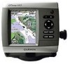
Garmin GPSMAP 440s Support Question
Garmin GPSMAP 440s Support Question
Find answers below for this question about Garmin GPSMAP 440s - Marine GPS Receiver.Need a Garmin GPSMAP 440s manual? We have 4 online manuals for this item!
Question posted by Sealaxin on July 7th, 2011
User Manual Download
Why am I unable to download the users manual?
Current Answers
Related Garmin GPSMAP 440s Manual Pages
Quick Reference Guide - Page 2

...move through menus, highlight fields, and enter data. Select MENU to manually adjust the backlight. From the Home screen, select Information > User Data > Routes. 2.
Press left or right on the track log:...to adjust the range of the map.
ROCKER-Press up, down on the unit, the GPS receiver must collect satellite data and establish the current location. MARK-Press to turn on lists,...
Declaration of Conformity - Page 1
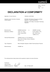
GARMIN (Europe) Ltd, The Quadrangle, Abbey Park Ind. Estate, Romsey, Hampshire, SO51 9DL, U.K. Marine Navigation Equipment (Global Positioning System Receiver)
GPSMAP 4x0
The undersigned does hereby declare that the equipment complies to which Conformity is Declared: Communications
1999/5/EC, 2004/108/EC
EN 60945: 2002 Maritime ...
Owner's Manual - Page 3
... Sonar: page 50. • Alarms and Messages: page 71.
Introduction
This manual includes information for the following products:
GPSMAP® 430/430s GPSMAP 431/431s GPSMAP 530/530s GPSMAP 531/531s GPSMAP 540/540s GPSMAP 541/541s
GPSMAP 440/440s GPSMAP 441/441s GPSMAP 535/535s GPSMAP 536/536s GPSMAP 545/545s GPSMAP 546/546s
Tips and Shortcuts
• Press HOME from any screen to...
Owner's Manual - Page 4
... 34 Viewing a Compass 34 Viewing Numbers 34 Viewing Trip Information 35 Viewing Fuel Gauges 35 Viewing Tide-station Information 36 Viewing Current Information 36 Viewing User Data 37 Viewing Other Vessels 40
GPSMAP 400/500 Series Owner's Manual
Owner's Manual - Page 11
...and the position icon displays a flashing question mark.
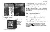
GPSMAP 400/500 Series Owner's Manual Press to page up or down on lists. Acquiring GPS Satellite Signals
When you turn the unit on or... MENU HOME
Getting Started
POWER/BACKLIGHT-Press and hold to turn on the unit, the GPS receiver must collect satellite data and establish the current location.
ROCKER-Press to adjust the range ...
Owner's Manual - Page 12
...SD cards to set speed, track control, and position. Using Simulator Mode
Simulator mode turns the GPS receiver off . To turn on the lower-right corner of the unit.
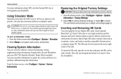
Restoring the Original Factory Settings
... The unit does not track satellites in until it from the chartplotter.
GPSMAP 400/500 Series Owner's Manual
The SD card slot is turned off for use indoors or for practice.
...
Owner's Manual - Page 13

...clicking Help > Check for Software Updates, or check the Garmin Web site at www.garmin.com.
Note: Mariner's Eye 3D, Fish Eye 3D, and Fishing charts are available only if you use sonar features.
•... 27). • Information-view information including dashboard options,
tides, currents, celestial data, user data, and information about other screens. GPSMAP 400/500 Series Owner's Manual
Owner's Manual - Page 31
... the AIS signal status, MMSI, GPS speed, GPS heading, and other information that appears using a trail, or turn the trail off.
Select AIS Vessel. Heading-allows you to select the AIS vessel. 4. Select Navigation Chart, Fishing Chart, Perspective 3D, or
Mariner's Eye 3D. 3. GPSMAP 400/500 Series Owner's Manual
25 Select Navigation Chart, Fishing Chart...
Owner's Manual - Page 39
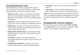
... unit. The BlueChart g2 Vision Mariner's Eye 3D is more detailed than the preloaded data.
• Fish Eye 3D-provides an underwater 3D view that visually represents the sea floor according to the information on BlueChart g2 Vision-compatible Garmin GPS units. GPSMAP 400/500 Series Owner's Manual
33 Using BlueChart g2 Vision
Optional...
Owner's Manual - Page 40

... and the type of numerical information. You can view and customize numerical data including depth, GPS information, and navigation information.
To customize the Numbers screen: 1. Press MENU and select Configure.
34
GPSMAP 400/500 Series Owner's Manual Viewing Information
Viewing Information
Use the Information screen to six fields of information shown in each...
Owner's Manual - Page 52

...you are off course by a specified distance.
Note: You must be receiving NMEA sonar depth data or using the system (GPS) clock.
Anchor Drag-set an alarm to sound when the unit detects...Configure > Alarms > Sonar.
The unit must be on for large fish only.
46
GPSMAP 400/500 Series Owner's Manual
Use the Rocker to sound when the transducer reports a temperature that is less than the...
Owner's Manual - Page 53
...measuring up to the water line (transducer installed on or off: marine, tornado, severe
storm, flood, or flash flood. Setting the... to XM WX Weather and a connected Garmin XM WX weather receiver to view weather information (page 60).
1. Keel Offset-offset the...of the keel), enter a (-) negative number. GPSMAP 400/500 Series Owner's Manual
47
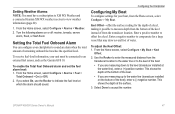
Configuring the Chartplotter
Configuring My Boat
To ...
Owner's Manual - Page 56
... GPSMAP 431s GPSMAP 530s GPSMAP 531s GPSMAP 540s GPSMAP 541s
GPSMAP 440s GPSMAP 441s GPSMAP 535s GPSMAP 536s GPSMAP 545s GPSMAP 546s
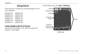
Understanding the Full Screen
Select the Full Screen option to view a full-screen graph of the
transducer's sonar readings. Depth Temperature
Speed
Suspended targets
Transducer frequency or beam width
Full Screen
Range
50
GPSMAP 400/500 Series Owner's Manual...
Owner's Manual - Page 61
...or a NMEA 2000 network.
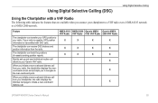
If your radio is capable, GPS position information is transmitted with a VHF Radio
The following ...positions of vessels sending position reports.
The chartplotter can receive DSC distress and position information from your Garmin VHF ...with DSC calls. Feature
The chartplotter can transfer your GPS position to your chartplotter, the radio displays the Distress...
Owner's Manual - Page 69
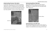
... by a red line). The light blue lines on the red line display the projected locations received from the National Hurricane Center. GPSMAP 400/500 Series Owner's Manual 63 To view information about the warning, select the county. Marine Warning
Hurricane
Understanding County Warnings When the National Weather Service issues a weather warning for the warning...
Owner's Manual - Page 75
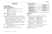
.../531/540/541: 5.0 in . GPSMAP 535/536/545/546: 5.0 in .
GPSMAP 431/431s GPSMAP 441/441s GPSMAP 531/531s GPSMAP 541/541s
High-sensitivity, 12 parallel channel, WAAS-capable receiver. diagonal (12.7 cm), Full VGA display with adjustable brightness, 320 × 234 pixels. GPSMAP 430/430s GPSMAP 530/530s GPSMAP 540/540s
GPSMAP 440/440s GPSMAP 535/535s GPSMAP 545/545s
High-sensitivity, 14...
Owner's Manual - Page 76
GPS Accuracy: Position: Appendix
Acquisition Times: (Average acquisition times for a stationary receiver with a clear view of the sky.) GPSMAP 430/430s GPSMAP 440/440s GPSMAP 530/530s GPSMAP 535/535s GPSMAP 530/540s GPSMAP 535/545s
Warm:* Approximately 15 seconds Cold:** Approximately 45 seconds
GPSMAP 431/431s GPSMAP 441/441s GPSMAP 531/531s GPSMAP 541/541s
Warm:* Approximately 1 second Cold:** ...
Owner's Manual - Page 77
...distance range. Antenna Input is Shorted-a part of the userset value.
GPSMAP 400/500 Series Owner's Manual 71 Can't Read User Card-error reading card;
Alarm Clock-the alarm clock has sounded.
... Write User Card, Card May Be Full-error reading card;
Alarms and Messages
The unit uses an on-screen message system to unit operating characteristics. Accuracy Alarm-the GPS accuracy has...
Owner's Manual - Page 79
...of safe depth settings. Track Log Full-the track log is full.
GPSMAP 400/500 Series Owner's Manual 73 Shallow Water Alarm-the Shallow Water Alarm depth has been reached. ...user data being present in memory. The oldest track log points were deleted to create memory space. Modify the track name or delete the existing track. Transfer Complete-the unit has finished uploading or downloading...
Owner's Manual - Page 83

...46 clock 46 collision 26, 49 deep water 46 fish 46 fuel 47 GPS accuracy 46 navigation 45 safe-zone 49 shallow water 46 sonar 46 water temp...
detail 14 fish eye 3D 18 fishing 19 mariner's eye 3D 16 navigation 8 settings 12 cleaning the unit 74 Clear User Data 37 collision alarm 26, 49 colors,... Data Transfer 44 gauges, fuel 35 go to 27 GPS 5, 41, 70 Grid (North) 42 guide to 27
H
Hazard Colors 17 heading ...
Similar Questions

How Do I Go Into Simulation Mode On A Garmin Marine Gps Modle741xs
how do I use simulation mode on a garmin 741xs marine ver
how do I use simulation mode on a garmin 741xs marine ver
(Posted by Curthupp 6 years ago)


How Can I Add New Waypoints To A Garmin 440s With Written Coordinates?
I sold my old Garmin GPS but wrote the locations of all my waypoints in paper. I bought a Garmin 440...
I sold my old Garmin GPS but wrote the locations of all my waypoints in paper. I bought a Garmin 440...
(Posted by enriqueluismedina 11 years ago)

Do You Have User Manual Of 6012 In Arabic Language
(Posted by workshop372 12 years ago)

440s Startup Option
Isn't there an option to set brightness and depth, fishfinder etc on startup? Could swear I had this...
Isn't there an option to set brightness and depth, fishfinder etc on startup? Could swear I had this...
(Posted by brushr 12 years ago)