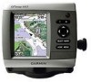
Garmin GPSMAP 440s Support Question
Garmin GPSMAP 440s Support Question
Find answers below for this question about Garmin GPSMAP 440s - Marine GPS Receiver.Need a Garmin GPSMAP 440s manual? We have 4 online manuals for this item!
Question posted by brushr on May 1st, 2011
440s Startup Option
Isn't there an option to set brightness and depth, fishfinder etc on startup? Could swear I had this but when I put my 440S back on after the winter it no longer does this and I can't find it in the manual.
Current Answers
Related Garmin GPSMAP 440s Manual Pages
Quick Reference Guide - Page 2

...Settings
To adjust the backlight: 1. Press left on the Rocker. Select Color Mode.
3.
Use the map pointer ( ) to select the location at the top of the first turn on the unit, the GPS receiver...or right on the Rocker to manually adjust the backlight.
the current track continues to access additional settings and configuration options;
When the unit loses satellite ...
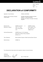
Declaration of Conformity - Page 1
...:
Authorised Representative:
Type of Council Directive:
Standard to the above Directives
Paul Morrow Quality Manager GARMIN (Europe) Ltd
Date: 30th March 2007 Marine Navigation Equipment (Global Positioning System Receiver)
GPSMAP 4x0
The undersigned does hereby declare that the equipment complies to which Conformity is Declared: Communications
1999/5/EC, 2004/108/EC
EN 60945...
Owner's Manual - Page 3
...: page 12. • Navigating to adjust the display settings. Introduction
This manual includes information for the following products:
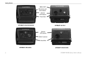
GPSMAP® 430/430s GPSMAP 431/431s GPSMAP 530/530s GPSMAP 531/531s GPSMAP 540/540s GPSMAP 541/541s
GPSMAP 440/440s GPSMAP 441/441s GPSMAP 535/535s GPSMAP 536/536s GPSMAP 545/545s GPSMAP 546/546s
Tips and Shortcuts
• Press HOME from any screen to...
Owner's Manual - Page 4
...
Table of Contents
Introduction i Tips and Shortcuts i Manual Conventions i Quick Links i Declaration of Conformity (DoC iv Product Registration iv Contact Garmin iv
Getting Started 1 Unit Overview 1 Turning the Unit On or Off 3 Initializing Unit Settings 3 Adjusting the Backlight 4 Using the Keypad 5 Acquiring GPS Satellite Signals 5 Using Simulator Mode 6 Viewing System...
Owner's Manual - Page 8
Getting Started
NMEA 2000® XM antenna with
audio adapter
External GPS antenna
Power/Data
GPSMAP 530/535/540/545
External GPS antenna GXM 31 antenna Power/Data
GPSMAP 441/541
GPSMAP 430x/440x
GPSMAP 430/431/440 GPSMAP 400/500 Series Owner's Manual
Owner's Manual - Page 11
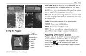
... bars disappear and the position icon displays a flashing question mark. GPSMAP 400/500 Series Owner's Manual Press and release to zoom in or out on a chart...settings and configuration options. Press to return to the Home screen. Using the Keypad
POWER/ BACKLIGHT
RANGE (-/+) ROCKER MARK SELECT MENU HOME
Getting Started
POWER/BACKLIGHT-Press and hold to turn on the unit, the GPS receiver...
Owner's Manual - Page 12
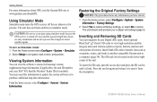
...optional BlueChart® g2 Vision® SD cards to set speed, track control, and position. Press the card in again and release it to adjust unit settings (page 3). Getting Started
For more information about GPS, visit the Garmin Web site at www.garmin.com/aboutGPS. Using Simulator Mode
Simulator mode turns the GPS receiver... chartplotter.
GPSMAP 400/500 Series Owner's Manual CAUTION: Do not...
Owner's Manual - Page 13

...features (page 27). • Information-view information including dashboard options,
tides, currents, celestial data, user data, and information about other screens.
Note: Mariner's Eye 3D, Fish Eye 3D, and Fishing charts are...-access unit and system settings (page 41). GPSMAP 400/500 Series Owner's Manual
Getting Started
• Sonar-set up and access sonar information (page 50).
Owner's Manual - Page 14

...zoom levels of the chart with g2 Vision GPSMAP 400/500 Series Owner's Manual Using Charts
Using Charts
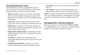
Your chartplotter has ...information on your preloaded maps, including buoys, lights, cables, depth soundings, marinas, and tide stations, in an overhead view.... Fishing charts, Fish Eye 3D, and Mariner's Eye 3D views are available when using optional BlueChart g2 Vision preprogrammed SD cards.
&#...
Owner's Manual - Page 15

... settings or options for the Navigation chart, press MENU. Waypoints & Tracks-view, add, and configure waypoints (page 29) and tracks (page 31). Data Bars-show or hide cruising, navigation, fishing, fuel, or sailing numbers. GPSMAP 400/500 Series Owner's Manual
Using... of the data on the screen.
• Navigation-turn the GPS Speed, GPS Heading, Depth, and GPS Position data bar on or off .
Owner's Manual - Page 23

... you have an XM subscription.) See page 60 for additional information. Mariner's Eye 3D Settings To access additional settings or options from the water. To customize the appearance of the screen. The scale... over
the navaid, the navaid is very shallow water. Mariner's Eye 3D (Water Hazard Colors) GPSMAP 400/500 Series Owner's Manual 17 Blue indicates deep water, yellow is shallow water, ...
Owner's Manual - Page 28
...Sonar. 2. Select the type of chart on the Navigation Chart
GPSMAP 400/500 Series Owner's Manual The information reported for the chart/sonar screen, press MENU. ...Sonar screen
Navigation/Sonar Combination
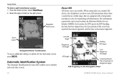
To access additional settings or options for each vessel includes the Maritime Mobile Service Identity (MMSI), the location, the GPS speed, the GPS heading, the time that are equipped with...
Owner's Manual - Page 31
...Mariner's Eye 3D. 3. Select AIS Vessel. GPSMAP 400/500 Series Owner's Manual
25 Select Navigation Chart, Fishing Chart, Perspective 3D, or
Mariner...allows you to set the projected heading time
for an AIS Vessel Note: The Fishing chart and Mariner's Eye 3D ...Mariner's Eye 3D. 3. Using Charts
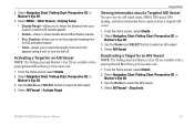
Viewing Information about a Targeted AIS Vessel You can view the AIS signal status, MMSI, GPS speed, GPS...
Owner's Manual - Page 39
...data and specified boat safe depth to determine the best course to your destination (page 43).
The BlueChart g2 Vision Mariner's Eye 3D is more ...GPS units. You can only use the SD card on the chart.
• Fishing Charts-provides a view of interest (POIs) along the shore. Navigating with enhanced bottom contours and without navigational data.
GPSMAP 400/500 Series Owner's Manual...
Owner's Manual - Page 47
... (page 4). Select Custom to set simulator options, such as a troubleshooting tool. When On is selected, the chartplotter will automatically turn Auto Power On or Off. GPS-view GPS satellites.
• Skyview-view the GPS satellite constellation. • WAAS/EGNOS-toggle WAAS (in North America) or EGNOS
GPSMAP 400/500 Series Owner's Manual
Configuring the Chartplotter
(in Europe...
Owner's Manual - Page 49

... to the shore you change this setting while navigating.
GPSMAP 400/500 Series Owner's Manual
43 Proceed to step 9.
• If the Auto Guidance line is satisfactory, select MENU > Navigation Options > Stop Navigation.
The available values for your boat or drop anchor.
2.
Auto Guidance-set the automatic guidance parameters:
• Safe Depth-set the distance from shore...
Owner's Manual - Page 50

...0183 output sentences for most AIS receivers.
Determine whether the line safely avoids...the Auto Guidance line is satisfactory, select MENU > Navigation Options > Stop Navigation. Proceed to known obstacles, from the ... system, and Garmin NMEA settings.
44
GPSMAP 400/500 Series Owner's Manual Serial Port 2 (if supported...Garmin Remote Sonar Transfer (GPSMAP 430/440/530/540/535/545)-...
Owner's Manual - Page 58

...select Sonar > Sonar Setup. Press MENU to the left as information is received. The graph scrolls to set the depth of the water. If using a temperature-capable transducer, the Temp Log ...settings universal to the water speed of the screen.
52
GPSMAP 400/500 Series Owner's Manual Using Sonar
Understanding the Temp Log Screen
If you are shown in the top-left corner. Temp and depth...
Owner's Manual - Page 76
GPS Accuracy: Position: Appendix
Acquisition Times: (Average acquisition times for a stationary receiver with a clear view of the sky.) GPSMAP 430/430s GPSMAP 440/440s GPSMAP 530/530s GPSMAP 535/535s GPSMAP 530/540s GPSMAP 535/545s
Warm:* Approximately 15 seconds Cold:** Approximately 45 seconds
GPSMAP 431/431s GPSMAP 441/441s GPSMAP 531/531s GPSMAP 541/541s
Warm:* Approximately 1 second Cold:** ...
Owner's Manual - Page 83

...charts
detail 14 fish eye 3D 18 fishing 19 mariner's eye 3D 16 navigation 8 settings 12 cleaning the unit 74 Clear User Data ... transfer 37 Declaration of Conformity iv delete a waypoint 30 depth line 52 depth waypoint 53 Detail, chart 14 Details, AIS 25 Display ...GPS 5, 41, 70 Grid (North) 42 guide to 27
H
Hazard Colors 17 heading 42 Heading Line 14 Head Up 13
GPSMAP 400/500 Series Owner's Manual 77
Similar Questions

How Do I Go Into Simulation Mode On A Garmin Marine Gps Modle741xs
how do I use simulation mode on a garmin 741xs marine ver
how do I use simulation mode on a garmin 741xs marine ver
(Posted by Curthupp 6 years ago)

No Depth Readings On Gpsmap546s
Have cleaned pins on data cable, transducer, both hot wire and ground connection on data cable. Boug...
Have cleaned pins on data cable, transducer, both hot wire and ground connection on data cable. Boug...
(Posted by sue1953bc 7 years ago)

Garmin Gpsmap 440s How To Guide
(Posted by josecsu 9 years ago)

How Can I Add New Waypoints To A Garmin 440s With Written Coordinates?
I sold my old Garmin GPS but wrote the locations of all my waypoints in paper. I bought a Garmin 440...
I sold my old Garmin GPS but wrote the locations of all my waypoints in paper. I bought a Garmin 440...
(Posted by enriqueluismedina 11 years ago)

How To Enter Waypoints
On A Garmin 440s
(Posted by mpnorthport 12 years ago)