Owner's Manual
Page 30
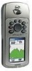
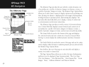
... or ambient pressure plots as plotting over time, plotting over distance, displaying the zoom ranges of measurement, viewing elevation or pressure points, and resetting data displays. Two user selectable data fields allow you with the current elevation, rate of ascent/descent, a profile of...and how it is located at the top of the page are user selectable and display a variety of recorded or current data. GPSmap 76CS GPS Navigation The Altimeter Page Range Grid Measurement Scale Selectable Data Fields Elevation Profile Plot over Distance Elevation Status Field Rate ...
... or ambient pressure plots as plotting over time, plotting over distance, displaying the zoom ranges of measurement, viewing elevation or pressure points, and resetting data displays. Two user selectable data fields allow you with the current elevation, rate of ascent/descent, a profile of...and how it is located at the top of the page are user selectable and display a variety of recorded or current data. GPSmap 76CS GPS Navigation The Altimeter Page Range Grid Measurement Scale Selectable Data Fields Elevation Profile Plot over Distance Elevation Status Field Rate ...

Owner's Manual
Page 31
Use the "Reset" option to clear recorded data from the Options Menu and then press in barometric pressure for your location, you navigate over a set period of time. Adjust time and distance measurement as you can plot a profile of time or changes over Time Plot 21 GPSmap 76CS GPS Navigation The Altimeter...
Use the "Reset" option to clear recorded data from the Options Menu and then press in barometric pressure for your location, you navigate over a set period of time. Adjust time and distance measurement as you can plot a profile of time or changes over Time Plot 21 GPSmap 76CS GPS Navigation The Altimeter...

Owner's Manual
Page 34
...Descent data, or only the Maximum Elevation 3. You can reset Elevation data such as Minimum Elevation, all categories shown on the page, highlight "Select All" and press ENTER. 24 GPSmap 76CS GPS Navigation The Altimeter Page Resets or Deletes all items on the page Elevation over Distance ...Plot Unselects all checked items on the page Resets or Deletes only those items that are checked Delete Prompt Reset You can reset the elevation data and the ...
...Descent data, or only the Maximum Elevation 3. You can reset Elevation data such as Minimum Elevation, all categories shown on the page, highlight "Select All" and press ENTER. 24 GPSmap 76CS GPS Navigation The Altimeter Page Resets or Deletes all items on the page Elevation over Distance ...Plot Unselects all checked items on the page Resets or Deletes only those items that are checked Delete Prompt Reset You can reset the elevation data and the ...

Owner's Manual
Page 36
...Menu Big Numbers Option 26 Using the Trip Computer Page The Trip Computer Page provides you select individual items, select all and unselect all. Reset Page You can use the "Big Numbers" option which shows fewer fields with larger displays. Selecting the "Restore Defaults" option ... computer data, clearing the Track Log and deleting Saved Tracks, Waypoints and Routes. If you want to change. The Reset Page offers options for navigation. GPSmap 76CS GPS Navigation The Trip Computer Page Select "Change Data Fields" or press the ROCKER key to highlight a field you ...
...Menu Big Numbers Option 26 Using the Trip Computer Page The Trip Computer Page provides you select individual items, select all and unselect all. Reset Page You can use the "Big Numbers" option which shows fewer fields with larger displays. Selecting the "Restore Defaults" option ... computer data, clearing the Track Log and deleting Saved Tracks, Waypoints and Routes. If you want to change. The Reset Page offers options for navigation. GPSmap 76CS GPS Navigation The Trip Computer Page Select "Change Data Fields" or press the ROCKER key to highlight a field you ...

Owner's Manual
Page 78
... "Save Always" option, be certain to return this reason be certain to switch back to manually calibrate when you may need to reset your location for your current location. For this setting back to function as a barometer or to the "Save When Power On" ...determe the accurate barometric pressure at the next start-up. To setup the Altimeter: 1. If not, you have accurate elevation or pressure data. GPSmap 76CS GPS Navigation Altimeter Setup Important - Select a method of three methods: Enter the correct elevation: this requires a reliable source to select from ...
... "Save Always" option, be certain to return this reason be certain to switch back to manually calibrate when you may need to reset your location for your current location. For this setting back to function as a barometer or to the "Save When Power On" ...determe the accurate barometric pressure at the next start-up. To setup the Altimeter: 1. If not, you have accurate elevation or pressure data. GPSmap 76CS GPS Navigation Altimeter Setup Important - Select a method of three methods: Enter the correct elevation: this requires a reliable source to select from ...

Owner's Manual
Page 83
... key to highlight the 'Start' field and then press ENTER. To reset the stopwatch: With the stopwatch stopped, use the ROCKER key to highlight the 'Lap' field and then press ENTER. GPSmap 76CS GPS Features Stopwatch Lap Options Menu Stopwatch Page Setting Lap By Distance 73 To set...' and press ENTER. Choose 'Set Lap Distance' and press ENTER. 2. Use the ROCKER key to highlight the field you to use the GPSmap 76CS as a stopwatch, which includes a lap timer. Stopwatch This feature allows you wish to change and then press ENTER. To stop the stopwatch: Use ...
... key to highlight the 'Start' field and then press ENTER. To reset the stopwatch: With the stopwatch stopped, use the ROCKER key to highlight the 'Lap' field and then press ENTER. GPSmap 76CS GPS Features Stopwatch Lap Options Menu Stopwatch Page Setting Lap By Distance 73 To set...' and press ENTER. Choose 'Set Lap Distance' and press ENTER. 2. Use the ROCKER key to highlight the field you to use the GPSmap 76CS as a stopwatch, which includes a lap timer. Stopwatch This feature allows you wish to change and then press ENTER. To stop the stopwatch: Use ...

Owner's Manual
Page 96
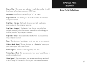
Off Course - The maximum speed you maintain your vehicle was reset. Speed - Sunrise - Speed - Sunset - Time To Next - The estimated time enroute to the next point on a route. The distance off your current speed and course. ... to travel to your route, if you have traveled for all trips. Time To Destination - The time of sunrise for the current date and location. GPSmap 76CS Appendix Data Field Definitions 86 Odometer - The total distance you maintain your direct course line, right or left. Speed - Speed -
Off Course - The maximum speed you maintain your vehicle was reset. Speed - Sunrise - Speed - Sunset - Time To Next - The estimated time enroute to the next point on a route. The distance off your current speed and course. ... to travel to your route, if you have traveled for all trips. Time To Destination - The time of sunrise for the current date and location. GPSmap 76CS Appendix Data Field Definitions 86 Odometer - The total distance you maintain your direct course line, right or left. Speed - Speed -
Owner's Manual
Page 97
Total - The total time the unit has been tracking since the Trip Computer was reset. Vertical Speed - GPSmap 76CS Appendix Data Field Definitions 87 The current time and date. Your direction of travel . Trip Odometer - Moving - Stopped - The direction of acsent... in 12 or 24 hour format in motion, since the Trip Computer was reset). The measurement of your rate of , and distance to a predetermined altitude. Water Speed - The data acquired from measurement devices interfaced to the GPSmap 76CS is used to get back on an active route. The rate of travel ...
Total - The total time the unit has been tracking since the Trip Computer was reset. Vertical Speed - GPSmap 76CS Appendix Data Field Definitions 87 The current time and date. Your direction of travel . Trip Odometer - Moving - Stopped - The direction of acsent... in 12 or 24 hour format in motion, since the Trip Computer was reset). The measurement of your rate of , and distance to a predetermined altitude. Water Speed - The data acquired from measurement devices interfaced to the GPSmap 76CS is used to get back on an active route. The rate of travel ...

Owner's Manual
Page 107
... Position Format 66, 92 Projecting a Point 30 Proximity Waypoint 70 R Reset Trip Page 26 Routes 51-55 Creating 51 Copying 55 Deleting 55 Editing 55 Profile 55 Navigating 55 Reversing 53 Vertical Profile 55 Routing Setup 64 GPSmap 76CS Appendix Index S Satellite Page 4 Saving the Tracklog 47 Selecting a Page...
... Position Format 66, 92 Projecting a Point 30 Proximity Waypoint 70 R Reset Trip Page 26 Routes 51-55 Creating 51 Copying 55 Deleting 55 Editing 55 Profile 55 Navigating 55 Reversing 53 Vertical Profile 55 Routing Setup 64 GPSmap 76CS Appendix Index S Satellite Page 4 Saving the Tracklog 47 Selecting a Page...

