Owner's Manual
Page 3
...-GPS enhanced game, etc. i This Owner's Manual and Reference Guide is located in the U.S.A. takes you through the process of the GPSmap 76CS functional features. Serial Number: Product Registration Connect to keep your PC and downloading detailed maps. takes you through installing batteries, using our on the Home Page and follow instructions for choosing the Garmin GPSmap 76CS handheld navigation system. GPSmap 76CS Introduction Preface Contact Garmin If you should encounter any questions, in the battery...
...-GPS enhanced game, etc. i This Owner's Manual and Reference Guide is located in the U.S.A. takes you through the process of the GPSmap 76CS functional features. Serial Number: Product Registration Connect to keep your PC and downloading detailed maps. takes you through installing batteries, using our on the Home Page and follow instructions for choosing the Garmin GPSmap 76CS handheld navigation system. GPSmap 76CS Introduction Preface Contact Garmin If you should encounter any questions, in the battery...

Owner's Manual
Page 8
... of all driving conditions at all times, and not become distracted by the unit to place and secure the device so that it is unsafe to impact it in a collision. Airbags expand with a GPSmap 76CS installed to pay full attention to airbag safety precautions contained in the vehicle owner's manual. WARNING: For use in vehicles, it will not...
... of all driving conditions at all times, and not become distracted by the unit to place and secure the device so that it is unsafe to impact it in a collision. Airbags expand with a GPSmap 76CS installed to pay full attention to airbag safety precautions contained in the vehicle owner's manual. WARNING: For use in vehicles, it will not...

Owner's Manual
Page 13
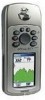
Refer to a PC for faster data transfer. GPSmap 76CS Getting Started Unit Features GPS Antenna (on front of unit) • Provides quick satellite acquisition. Battery Compartment Cover (weather cover) USB Connector Port (under weather cover) • Provides interface to page 89 for data transfer. • Provides auxiliary AC or DC power adapter connection. Auxiliary GPS Antenna Connector (under weather cover) • Provides serial port interface to a remote GPS antenna (MCX connector). External Power and Data Connector Port (under weather cover) • Provides connection...
Refer to a PC for faster data transfer. GPSmap 76CS Getting Started Unit Features GPS Antenna (on front of unit) • Provides quick satellite acquisition. Battery Compartment Cover (weather cover) USB Connector Port (under weather cover) • Provides interface to page 89 for data transfer. • Provides auxiliary AC or DC power adapter connection. Auxiliary GPS Antenna Connector (under weather cover) • Provides serial port interface to a remote GPS antenna (MCX connector). External Power and Data Connector Port (under weather cover) • Provides connection...
Owner's Manual
Page 15
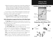
...;ecting the satellite signals. 5. Active Navigation is displayed. GPSmap 76CS Getting Started Initialization & The Satellite Page Position Arrow Map Scale Map Item Details Map Page with Current Position Arrow Navigating with a route line, and leaves a trail (track log) of travel data. A previous path of where you to avoid objects that has been stored (logged) in the GPSmap 76CS. The Status Bar at the top of navigating to indicate position accuracy and location coordinates. The Trip...
...;ecting the satellite signals. 5. Active Navigation is displayed. GPSmap 76CS Getting Started Initialization & The Satellite Page Position Arrow Map Scale Map Item Details Map Page with Current Position Arrow Navigating with a route line, and leaves a trail (track log) of travel data. A previous path of where you to avoid objects that has been stored (logged) in the GPSmap 76CS. The Status Bar at the top of navigating to indicate position accuracy and location coordinates. The Trip...

Owner's Manual
Page 17
... releasing. GPSmap 76CS Getting Started The Main Page Features Status Bar Battery Power Acquiring Satellites Backlight is On Alarm is Set Auxiliary Power 2-Dimension Navigation 3-Dimension Navigation Electronic Compass ON USB is in the operation of the unit occurs, an on-screen message will display to battery power level.) On-Screen Messages 7 This icon displays when the backlight is functioning. • Alarm Clock: this icon displays whenever the alarm is set. • USB cable connection displays when the unit is Connected Backlight Adjustment Slider (Brightnesses varies...
... releasing. GPSmap 76CS Getting Started The Main Page Features Status Bar Battery Power Acquiring Satellites Backlight is On Alarm is Set Auxiliary Power 2-Dimension Navigation 3-Dimension Navigation Electronic Compass ON USB is in the operation of the unit occurs, an on-screen message will display to battery power level.) On-Screen Messages 7 This icon displays when the backlight is functioning. • Alarm Clock: this icon displays whenever the alarm is set. • USB cable connection displays when the unit is Connected Backlight Adjustment Slider (Brightnesses varies...
Owner's Manual
Page 18
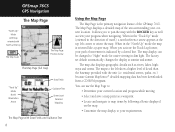
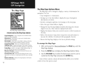
GPSmap 76CS GPS Navigation The Map Page "North Up" Mode with Map oriented with North at the top The Map Scale The Map Page Position Arrow The Map Page (full map) "Track Up" Mode North Orientation Arrow Data Fields Guidance Text Street Level Detailed Mapping The Map Page with Data Fields and Guidance Text 8 Using the Map Page The Map Page is the primary navigation feature of travel), a north reference arrow appears at sunrise and sunset...
GPSmap 76CS GPS Navigation The Map Page "North Up" Mode with Map oriented with North at the top The Map Scale The Map Page Position Arrow The Map Page (full map) "Track Up" Mode North Orientation Arrow Data Fields Guidance Text Street Level Detailed Mapping The Map Page with Data Fields and Guidance Text 8 Using the Map Page The Map Page is the primary navigation feature of travel), a north reference arrow appears at sunrise and sunset...
Owner's Manual
Page 20
...; Arrange up to four data fields to customize the Map Page and press the ENTER key. Some of roads and other geographic features. • Restore the Map Page display to change data field types. Recalculates a route and is disabled when there is used. Change Data Fields - Measures the distance from your preferences. GPSmap 76CS GPS Navigation The Map Page The Map Page Options Menu A Quick Look at the top of...
...; Arrange up to four data fields to customize the Map Page and press the ENTER key. Some of roads and other geographic features. • Restore the Map Page display to change data field types. Recalculates a route and is disabled when there is used. Change Data Fields - Measures the distance from your preferences. GPSmap 76CS GPS Navigation The Map Page The Map Page Options Menu A Quick Look at the top of...
Owner's Manual
Page 25
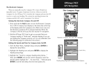
... unit uses the GPS receiver for Compass Auto On/Off: 1. GPSmap 76CS GPS Navigation The Compass Page Electronic Compass "On" and "Off" messages Speed Setting Time Delay Options Heading Setup Page with Compass Switch Options 15 A Compass Icon displays in use the numeric keypad to conserve batteries. When not in the Status Bar at the top of the display when the Compass is On. When the Compass is not calibrated. (See the following page for calibration instructions.) Setting the Speed...
... unit uses the GPS receiver for Compass Auto On/Off: 1. GPSmap 76CS GPS Navigation The Compass Page Electronic Compass "On" and "Off" messages Speed Setting Time Delay Options Heading Setup Page with Compass Switch Options 15 A Compass Icon displays in use the numeric keypad to conserve batteries. When not in the Status Bar at the top of the display when the Compass is On. When the Compass is not calibrated. (See the following page for calibration instructions.) Setting the Speed...

Owner's Manual
Page 38
... a Waypoint Information Page for a Map Point with Data 28 Waypoint Page for reference. Another method for additional guidance to the Find Menu Waypoints List. If there is the Man Overboard (MOB) feature. GPSmap 76CS GPS Navigation Using Waypoints Map Item selected as a waypoint. With the Map Page displayed, move the panning arrow (map pointer) to the map item you cannot stop quickly and must return to create a user waypoint here?" Typically an application for marking a location on water...
... a Waypoint Information Page for a Map Point with Data 28 Waypoint Page for reference. Another method for additional guidance to the Find Menu Waypoints List. If there is the Man Overboard (MOB) feature. GPSmap 76CS GPS Navigation Using Waypoints Map Item selected as a waypoint. With the Map Page displayed, move the panning arrow (map pointer) to the map item you cannot stop quickly and must return to create a user waypoint here?" Typically an application for marking a location on water...
Owner's Manual
Page 46
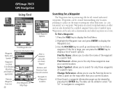
...;nd a Waypoint: 1. The data can be edited or select "Go To" to navigate to select a point on the map other Find item (i.e. GPSmap 76CS GPS Navigation Using Find Find Waypoint Options Find Waypoints List Waypoint Information Page Waypoint Name and Symbol Enter a notation using the Waypoint Location on-screen keypad Coordinates, Elevation and Depth (if applicable) Distance and Direction from Current Location Navigate to Remove a Waypoint Waypoint from List 36 View Waypoint on Map Page Location Searching for a Waypoint The Waypoints List is...
...;nd a Waypoint: 1. The data can be edited or select "Go To" to navigate to select a point on the map other Find item (i.e. GPSmap 76CS GPS Navigation Using Find Find Waypoint Options Find Waypoints List Waypoint Information Page Waypoint Name and Symbol Enter a notation using the Waypoint Location on-screen keypad Coordinates, Elevation and Depth (if applicable) Distance and Direction from Current Location Navigate to Remove a Waypoint Waypoint from List 36 View Waypoint on Map Page Location Searching for a Waypoint The Waypoints List is...

Owner's Manual
Page 58
... well. Press ENTER again to save the new track to Save the track (OK), Delete, View it on the map page (Show On Map). A map showing the entire track appears with a Save button. 4. To view a Track on the Map Page Start Calculation Stop Calculation Save Calculated Track 48 4. The Saved Track Page allows you to the Saved Tracks List. On-screen buttons at the bottom of a Track: 1. GPSmap 76CS GPS Navigation Using Tracks 151ST ST Saved Track Page Area Calculation Option Saved Track on the...
... well. Press ENTER again to save the new track to Save the track (OK), Delete, View it on the map page (Show On Map). A map showing the entire track appears with a Save button. 4. To view a Track on the Map Page Start Calculation Stop Calculation Save Calculated Track 48 4. The Saved Track Page allows you to the Saved Tracks List. On-screen buttons at the bottom of a Track: 1. GPSmap 76CS GPS Navigation Using Tracks 151ST ST Saved Track Page Area Calculation Option Saved Track on the...

Owner's Manual
Page 64
... field and press ENTER to delete all routes?" GPSmap 76CS GPS Navigation Using Routes Saved Routes Options Route Options To delete the route: 1. Route Leg Transition Options Route on the route, select "Off Road Transition" and press ENTER to the next leg point when you really want to display the list of that point. Select "Yes" and press ENTER. To clear the saved routes list, select "Delete All Routes" and press ENTER. To select the...
... field and press ENTER to delete all routes?" GPSmap 76CS GPS Navigation Using Routes Saved Routes Options Route Options To delete the route: 1. Route Leg Transition Options Route on the route, select "Off Road Transition" and press ENTER to the next leg point when you really want to display the list of that point. Select "Yes" and press ENTER. To clear the saved routes list, select "Delete All Routes" and press ENTER. To select the...
Owner's Manual
Page 68
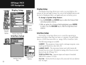
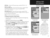
...of brightness which can significantly save on battery power. The proprietary format used when connecting your unit to a computer, external NMEA devices, a DGPS beacon receiver, etc. GPSmap 76CS GPS Navigation Display Setup Color Scheme Options Backlight Timeout Options Display Setup Page Interface Setup Level Selector Data Format Interface Setup Options Page 58 Display Setup The Display Setup Page allows you to control the input/output format used to exchange waypoint, route, track log and MapSource data with Garmin differential beacon receivers. To change a System Setup...
...of brightness which can significantly save on battery power. The proprietary format used when connecting your unit to a computer, external NMEA devices, a DGPS beacon receiver, etc. GPSmap 76CS GPS Navigation Display Setup Color Scheme Options Backlight Timeout Options Display Setup Page Interface Setup Level Selector Data Format Interface Setup Options Page 58 Display Setup The Display Setup Page allows you to control the input/output format used to exchange waypoint, route, track log and MapSource data with Garmin differential beacon receivers. To change a System Setup...
Owner's Manual
Page 69
... and enter the appropriate settings. RTCM In/NMEA Out - The beacon status, signal-to-noise ratio and distance to the GPS map 76CS, it is connected, Garmin format will not communicate through the Serial connection, while all other formats can be used by the Serial connection with the USB still connected. 59 RTCM In - Use the ROCKER key to highlight "Beacon" and press ENTER. If "User" is selected, the GPSmap 76CS...
... and enter the appropriate settings. RTCM In/NMEA Out - The beacon status, signal-to-noise ratio and distance to the GPS map 76CS, it is connected, Garmin format will not communicate through the Serial connection, while all other formats can be used by the Serial connection with the USB still connected. 59 RTCM In - Use the ROCKER key to highlight "Beacon" and press ENTER. If "User" is selected, the GPSmap 76CS...

Owner's Manual
Page 76
... (Military Time) hour formats. 3. To use the Time Setup feature: 1. Access the Time Setup Page. 2. Use the ROCKER and ENTER keys to choose the correct zone for your geographic location. Refer the UTC Chart on page 91. 4. Access the Units Setup Page. 2. GPSmap 76CS GPS Navigation Time Setup To set the correct time for your location. If you selected "Other", you to set the UTC Offset for "Other" Time Zones, see page 91. Highlight the Time Format fi...
... (Military Time) hour formats. 3. To use the Time Setup feature: 1. Access the Time Setup Page. 2. Use the ROCKER and ENTER keys to choose the correct zone for your geographic location. Refer the UTC Chart on page 91. 4. Access the Units Setup Page. 2. GPSmap 76CS GPS Navigation Time Setup To set the correct time for your location. If you selected "Other", you to set the UTC Offset for "Other" Time Zones, see page 91. Highlight the Time Format fi...

Owner's Manual
Page 90
... for data transfer. (Not shown) Carrying Case - Quick Start Guide - Provides auxiliary power from an automobile cigarette lighter. (Not shown) GA 27C Remote GPS Antenna - Allows enhanced satellite acquisition. Allows installation on a boat. GPSmap 76CS Appendix Accessories USB Interface Cable and MapSource Trip and Waypoint Manager CD-ROM with other manufacturers have been designed and tested specifically for use with Garmin products. Owner's Manual - Includes suction and magnetic mount options. Provides connection to...
... for data transfer. (Not shown) Carrying Case - Quick Start Guide - Provides auxiliary power from an automobile cigarette lighter. (Not shown) GA 27C Remote GPS Antenna - Allows enhanced satellite acquisition. Allows installation on a boat. GPSmap 76CS Appendix Accessories USB Interface Cable and MapSource Trip and Waypoint Manager CD-ROM with other manufacturers have been designed and tested specifically for use with Garmin products. Owner's Manual - Includes suction and magnetic mount options. Provides connection to...

Owner's Manual
Page 103
... or using it for navigation. GPSmap 76CS Appendix Loran TD Setup Location Setup Page (Position Format List with Loran TD selected.) Loran TD Setup Page 93 Press the MENU key twice to display the Main Menu, then press again to display the Loran Setup Page. 5. To change the settings of any of this, the unit can navigate to a TD coordinate anywhere in the world. For more information please read our LORAN TD Position Format...
... or using it for navigation. GPSmap 76CS Appendix Loran TD Setup Location Setup Page (Position Format List with Loran TD selected.) Loran TD Setup Page 93 Press the MENU key twice to display the Main Menu, then press again to display the Loran Setup Page. 5. To change the settings of any of this, the unit can navigate to a TD coordinate anywhere in the world. For more information please read our LORAN TD Position Format...

Owner's Manual
Page 104
... providing reliable signals with increased accuracy at any SBAS system should be several services of worldwide geostationary communication satellites that broadcast integrity information and differential correction data as explained below), but without fee. GPSmap 76CS Appendix WAAS and DGPS What is Differential GPS (DGPS)? What is WAAS? For this time WAAS is comparable to the MOPS (Minimum Operational Performance Standard...
... providing reliable signals with increased accuracy at any SBAS system should be several services of worldwide geostationary communication satellites that broadcast integrity information and differential correction data as explained below), but without fee. GPSmap 76CS Appendix WAAS and DGPS What is Differential GPS (DGPS)? What is WAAS? For this time WAAS is comparable to the MOPS (Minimum Operational Performance Standard...

Owner's Manual
Page 105
... RS-232 compatible, allowing easy interface to connect your GPSmap 76CS are accepted in RTCM SC-104 version 2.0 format through the "Data In" line. The input/output lines on page 58 of this unit allows you to a wide range of external devices, including PC's, differential beacon receivers, marine autopilots and /or a second GPS receiver. The NMEA 0183 version 3.01 interface format is the recommended beacon receiver for use with Bare Wire Leads...
... RS-232 compatible, allowing easy interface to connect your GPSmap 76CS are accepted in RTCM SC-104 version 2.0 format through the "Data In" line. The input/output lines on page 58 of this unit allows you to a wide range of external devices, including PC's, differential beacon receivers, marine autopilots and /or a second GPS receiver. The NMEA 0183 version 3.01 interface format is the recommended beacon receiver for use with Bare Wire Leads...

Owner's Manual
Page 107
... Over Time 20-21 Position Format 66, 92 Projecting a Point 30 Proximity Waypoint 70 R Reset Trip Page 26 Routes 51-55 Creating 51 Copying 55 Deleting 55 Editing 55 Profile 55 Navigating 55 Reversing 53 Vertical Profile 55 Routing Setup 64 GPSmap 76CS Appendix Index S Satellite Page 4 Saving the Tracklog 47 Selecting a Page 2 Setup Menu 57 Show Data Fields 10 Show Map Only 10 Sight 'N Go 17 Software Version (Operating...
... Over Time 20-21 Position Format 66, 92 Projecting a Point 30 Proximity Waypoint 70 R Reset Trip Page 26 Routes 51-55 Creating 51 Copying 55 Deleting 55 Editing 55 Profile 55 Navigating 55 Reversing 53 Vertical Profile 55 Routing Setup 64 GPSmap 76CS Appendix Index S Satellite Page 4 Saving the Tracklog 47 Selecting a Page 2 Setup Menu 57 Show Data Fields 10 Show Map Only 10 Sight 'N Go 17 Software Version (Operating...


