
Owner's Manual
Page 1
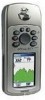
GPSMAP® 76CS with sensors and maps owner's manual
GPSMAP® 76CS with sensors and maps owner's manual
Owner's Manual
Page 3
... purchase, we invite you to re-register using our on the Home Page and follow instructions for choosing the Garmin GPSmap 76CS handheld navigation system. Be sure to your original sales receipt in a safe place or attach a photocopy inside the manual. NOTE: ... Fish, Sun and Moon and Games. contains the Garmin software license agreement, FCC and safety information, the Table of Contents and an overview of navigating with additional information about your purchase ensures you the best possible support from the GPSmap 76CS to keep your PC and downloading detailed maps. Appendix -
... purchase, we invite you to re-register using our on the Home Page and follow instructions for choosing the Garmin GPSmap 76CS handheld navigation system. Be sure to your original sales receipt in a safe place or attach a photocopy inside the manual. NOTE: ... Fish, Sun and Moon and Games. contains the Garmin software license agreement, FCC and safety information, the Table of Contents and an overview of navigating with additional information about your purchase ensures you the best possible support from the GPSmap 76CS to keep your PC and downloading detailed maps. Appendix -

Owner's Manual
Page 7
... to our web site at a reasonable cost. Virtually all GPS equipment. MAP DATA INFORMATION: One of the goals of Garmin is to provide customers with California's Proposition 65. The system is subject to the consumer. GPSmap 76CS Introduction Warnings and Precautions v Although the Garmin GPSmap 76CS is either not available or prohibitively expensive. If you have any... messages displayed to changes which is being provided in accordance with the most complete and accurate cartography that is available to us at http://www.garmin.com/ prop65.
... to our web site at a reasonable cost. Virtually all GPS equipment. MAP DATA INFORMATION: One of the goals of Garmin is to provide customers with California's Proposition 65. The system is subject to the consumer. GPSmap 76CS Introduction Warnings and Precautions v Although the Garmin GPSmap 76CS is either not available or prohibitively expensive. If you have any... messages displayed to changes which is being provided in accordance with the most complete and accurate cartography that is available to us at http://www.garmin.com/ prop65.

Owner's Manual
Page 9
...Page 26Using Time Setup 66 Units Setup 66 Heading Setup 67 Calibration Setup 67 Altimeter Setup 68 Welcome Page Setup 69 ..... GPSmap 76CS Introduction Table of Contents Section 1: Introduction i-iv Waypoints 27 Preface i Using Find 31 Software License Agreement ii The Main Menu...2: Getting Started 1-7 Battery Installation and Start Up 1 Key Functions 2 Unit Features 3 Initialization 4 The Satellite Page 4 Navigating with the GPSmap 76CS 5 The Main Page Sequence 6 The Main Page Features 7 The Setup Menu 57 System Setup 57 Display Setup 58 Interface Setup 58 Tones...
...Page 26Using Time Setup 66 Units Setup 66 Heading Setup 67 Calibration Setup 67 Altimeter Setup 68 Welcome Page Setup 69 ..... GPSmap 76CS Introduction Table of Contents Section 1: Introduction i-iv Waypoints 27 Preface i Using Find 31 Software License Agreement ii The Main Menu...2: Getting Started 1-7 Battery Installation and Start Up 1 Key Functions 2 Unit Features 3 Initialization 4 The Satellite Page 4 Navigating with the GPSmap 76CS 5 The Main Page Sequence 6 The Main Page Features 7 The Setup Menu 57 System Setup 57 Display Setup 58 Interface Setup 58 Tones...

Owner's Manual
Page 10
GPSmap 76CS Introduction Table of Contents Section 4: GPS Features 71-79 Calendar 71 Alarm Clock 72 Calculator 72 Stopwatch 73 Sun and Moon Tables 74 Hunt and Fish Tables 75 GPS Enhanced Games 76 Non-Enhanced Game 79 Section 5: Appendix 80-98 Accessories 80 Specifcations 82 Data Field Definitions 84 Connecting the GPSmap 76CS to a Computer 89 Downloading MapSource Map Data 90 UTC Offset Chart 91 Map Datums and Position Formats 92 Loran TD Setup 93 WAAS and DGPS 94 Wiring Diagram 95 Index 96 Limited Warranty 99 viii
GPSmap 76CS Introduction Table of Contents Section 4: GPS Features 71-79 Calendar 71 Alarm Clock 72 Calculator 72 Stopwatch 73 Sun and Moon Tables 74 Hunt and Fish Tables 75 GPS Enhanced Games 76 Non-Enhanced Game 79 Section 5: Appendix 80-98 Accessories 80 Specifcations 82 Data Field Definitions 84 Connecting the GPSmap 76CS to a Computer 89 Downloading MapSource Map Data 90 UTC Offset Chart 91 Map Datums and Position Formats 92 Loran TD Setup 93 WAAS and DGPS 94 Wiring Diagram 95 Index 96 Limited Warranty 99 viii

Owner's Manual
Page 12
PAGE/COMPASS Key • Press to cycle through lists, highlight fields, on-screen buttons, icons, enter data or move the map panning arrow. POWER/BACKLIGHT Key • Press and Hold to turn Compass On/Off. ENTER/MARK Key • Press and release to enter highlighted options, ... any other page, press to scroll up or down a list. MENU Key • Press and release to view options for MOB. GPSmap 76CS Getting Started Key Functions IN/OUT Zoom Keys • From the Map Page, press to zoom in or out. • From any time to mark your current location as a waypoint.
PAGE/COMPASS Key • Press to cycle through lists, highlight fields, on-screen buttons, icons, enter data or move the map panning arrow. POWER/BACKLIGHT Key • Press and Hold to turn Compass On/Off. ENTER/MARK Key • Press and release to enter highlighted options, ... any other page, press to scroll up or down a list. MENU Key • Press and release to view options for MOB. GPSmap 76CS Getting Started Key Functions IN/OUT Zoom Keys • From the Map Page, press to zoom in or out. • From any time to mark your current location as a waypoint.
Owner's Manual
Page 14
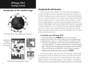
...Map Page to minutes. Highlight the appropriate solution and press ENTER. A bar graph at the bottom of the page displays the strength of solutions appears. Options Menu GPS Elevation display Satellite Page Acquiring Satellite Signals 4 Starting Up the GPS Receiver When you turn on the GPSmap 76CS...to search for initialization, select "New Location" from your original location, it takes only seconds to determine your general location so the GPSmap 76CS can also observe a sky view array of the satellites overhead with your direction of the sky. If the unit cannot get a ...
...Map Page to minutes. Highlight the appropriate solution and press ENTER. A bar graph at the bottom of the page displays the strength of solutions appears. Options Menu GPS Elevation display Satellite Page Acquiring Satellite Signals 4 Starting Up the GPS Receiver When you turn on the GPSmap 76CS...to search for initialization, select "New Location" from your original location, it takes only seconds to determine your general location so the GPSmap 76CS can also observe a sky view array of the satellites overhead with your direction of the sky. If the unit cannot get a ...
Owner's Manual
Page 15
... has been stored (logged) in the GPSmap 76CS. The Status Bar at the top of where you map details, your current location, marks your GPSmap 76CS, the solution could be as simple as moving slightly to a destination with GPSmap 76CS A Go To A Route A Track ...exits, points of travel. A direct path to a destination when using the GPSmap 76CS', each graphically displayed on the Map Page. Route - GPSmap 76CS Getting Started Initialization & The Satellite Page Position Arrow Map Scale Map Item Details Map Page with Current Position Arrow Navigating with a route line, and leaves a...
... has been stored (logged) in the GPSmap 76CS. The Status Bar at the top of where you map details, your current location, marks your GPSmap 76CS, the solution could be as simple as moving slightly to a destination with GPSmap 76CS A Go To A Route A Track ...exits, points of travel. A direct path to a destination when using the GPSmap 76CS', each graphically displayed on the Map Page. Route - GPSmap 76CS Getting Started Initialization & The Satellite Page Position Arrow Map Scale Map Item Details Map Page with Current Position Arrow Navigating with a route line, and leaves a...

Owner's Manual
Page 16
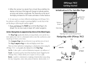
...Menu Satellite Page Options 6 Trip Computer Page Options Map Page Options There are no Menu Options at the Main Menu Page level Altimeter Page Options Compass Page Options When navigating a route, the Active Route Page also displays. GPSmap 76CS Getting Started The Main Page Sequence Whenever you ...turn on the GPSmap 76CS, the Power On Page is followed by the Satellite Page, which is the first of options...
...Menu Satellite Page Options 6 Trip Computer Page Options Map Page Options There are no Menu Options at the Main Menu Page level Altimeter Page Options Compass Page Options When navigating a route, the Active Route Page also displays. GPSmap 76CS Getting Started The Main Page Sequence Whenever you ...turn on the GPSmap 76CS, the Power On Page is followed by the Satellite Page, which is the first of options...
Owner's Manual
Page 18
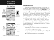
... 8 Using the Map Page The Map Page is the primary navigation feature of movement is oriented like a paper map. The map also displays geographic details such as view your progress when navigating. residential streets, parks, etc.) because Garmin MapSource® detailed mapping data has been... a north reference arrow appears at sunrise and sunset. The maps to your path of the GPSmap 76CS. The Map Page displays a detailed map of the area surrounding your current location and progress while moving • Select and save a map point as a waypoint. • Locate and navigate to :...
... 8 Using the Map Page The Map Page is the primary navigation feature of movement is oriented like a paper map. The map also displays geographic details such as view your progress when navigating. residential streets, parks, etc.) because Garmin MapSource® detailed mapping data has been... a north reference arrow appears at sunrise and sunset. The maps to your path of the GPSmap 76CS. The Map Page displays a detailed map of the area surrounding your current location and progress while moving • Select and save a map point as a waypoint. • Locate and navigate to :...

Owner's Manual
Page 19
... page to highlight and identify map items or to scroll the map to view areas not shown on the list. When navigating, Guidance Text will be confused with the Map Setup Page). GPSmap 76CS GPS Navigation The Map Page Zoom In Zoom Out Map Features Map Scales Accuracy Circle Panning Arrow ...word, "overzoom" displays just below the scale. The GPSmap 76CS uses both map resolution and GPS accuracy in order to be displayed at the top of the map. The map scale in so far that follow. In many instances the map displays an "Accuracy Circle" surrounding the "Position Icon." ...
... page to highlight and identify map items or to scroll the map to view areas not shown on the list. When navigating, Guidance Text will be confused with the Map Setup Page). GPSmap 76CS GPS Navigation The Map Page Zoom In Zoom Out Map Features Map Scales Accuracy Circle Panning Arrow ...word, "overzoom" displays just below the scale. The GPSmap 76CS uses both map resolution and GPS accuracy in order to be displayed at the top of the map. The map scale in so far that follow. In many instances the map displays an "Accuracy Circle" surrounding the "Position Icon." ...
Owner's Manual
Page 20
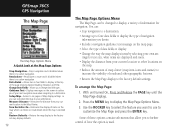
... no active navigation. Use the ROCKER key to select the feature you can customize the map to your current location to the factory default settings. GPSmap 76CS GPS Navigation The Map Page The Map Page Options Menu A Quick Look at the top of the page showing Speed, Heading, Elevation and ... size, what items are displayed and more. • Display the distance from your next navigation move when navigating to display at the Map Page Options Stop Navigation - Stops navigation and is disabled when there is used. Measures the distance from your preferences. Recalculate - Allows ...
... no active navigation. Use the ROCKER key to select the feature you can customize the map to your current location to the factory default settings. GPSmap 76CS GPS Navigation The Map Page The Map Page Options Menu A Quick Look at the top of the page showing Speed, Heading, Elevation and ... size, what items are displayed and more. • Display the distance from your next navigation move when navigating to display at the Map Page Options Stop Navigation - Stops navigation and is disabled when there is used. Measures the distance from your preferences. Recalculate - Allows ...
Owner's Manual
Page 21
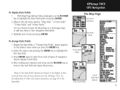
...eld. 4. Display the data fields, a "Change Data Fields" option appears on the options menu when you press the MENU key. 2. GPSmap 76CS GPS Navigation The Map Page Data Field Sub-Menu Two Data Fields To change Data Fields: 1. You can choose to highlight the first data field. ... After making your choice and press ENTER. Four Data Fields List of navigation data to the GPSmap 76CS, for an explanation of what each option represents, see page 84 of the Appendix. With Map Page Options Menu displayed, use the ROCKER key to move to the display of data received ...
...eld. 4. Display the data fields, a "Change Data Fields" option appears on the options menu when you press the MENU key. 2. GPSmap 76CS GPS Navigation The Map Page Data Field Sub-Menu Two Data Fields To change Data Fields: 1. You can choose to highlight the first data field. ... After making your choice and press ENTER. Four Data Fields List of navigation data to the GPSmap 76CS, for an explanation of what each option represents, see page 84 of the Appendix. With Map Page Options Menu displayed, use the ROCKER key to move to the display of data received ...

Owner's Manual
Page 22
...information when using one of the Setup Options on page 5. Guidance Text shows you select "Stop Navigation" from the Options Menu. With Map Page displayed, press the MENU key to display the Guidance Text Options Menu. 3. If you select "Show When Navigating" a guidance ...Always Show," "Never Show" or "Show When Navigating" and press ENTER to the Map Setup section of the navigation methods described on page 61. 12 Guidance Message when navigating GPSmap 76CS GPS Navigation The Map Page Guidance Text Options Menu GPS Status Message when not navigating To display Guidance Text...
...information when using one of the Setup Options on page 5. Guidance Text shows you select "Stop Navigation" from the Options Menu. With Map Page displayed, press the MENU key to display the Guidance Text Options Menu. 3. If you select "Show When Navigating" a guidance ...Always Show," "Never Show" or "Show When Navigating" and press ENTER to the Map Setup section of the navigation methods described on page 61. 12 Guidance Message when navigating GPSmap 76CS GPS Navigation The Map Page Guidance Text Options Menu GPS Status Message when not navigating To display Guidance Text...
Owner's Manual
Page 23
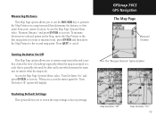
... and then determine the distance to that is zoomed to activate. GPSmap 76CS GPS Navigation The Map Page Measured Distance The "Measure Distance" Option Enabled Map Declutter "Off" Map Declutter "On" 13 Turning Declutter On/Off This Map Page option allows you to remove map item titles and icons that clutter the view of roadways especially when...
... and then determine the distance to that is zoomed to activate. GPSmap 76CS GPS Navigation The Map Page Measured Distance The "Measure Distance" Option Enabled Map Declutter "Off" Map Declutter "On" 13 Turning Declutter On/Off This Map Page option allows you to remove map item titles and icons that clutter the view of roadways especially when...
Owner's Manual
Page 24
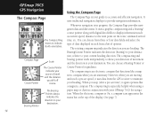
... when you drift off course. The compass ring is an electronic compass that functions like a magnetic compass. When you are stationary. GPSmap 76CS GPS Navigation Using the Compass Page The Compass Page The Compass Ring moves to provide navigation information. Compass Page Course Pointer Scale The ... the type of data displayed in the status bar at the top of options. Whenever navigation is especially helpful when using a paper map or chart in progress, the Compass Page provides navigation data and directions. You can choose a Bearing Pointer or Course Pointer for navigation...
... when you drift off course. The compass ring is an electronic compass that functions like a magnetic compass. When you are stationary. GPSmap 76CS GPS Navigation Using the Compass Page The Compass Page The Compass Ring moves to provide navigation information. Compass Page Course Pointer Scale The ... the type of data displayed in the status bar at the top of options. Whenever navigation is especially helpful when using a paper map or chart in progress, the Compass Page provides navigation data and directions. You can choose a Bearing Pointer or Course Pointer for navigation...
Owner's Manual
Page 27
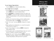
Or... 6. Highlight the "Go To" button and press ENTER to display the Map Page and begin navigation to activate the Sight 'N Go feature. Use the ROCKER key to highlight the Sight 'N Go option and press ENTER to the ... unit at eye level and line up the two sighting marks with the two sighting marks on a course line using the Course Pointer as a guide. GPSmap 76CS GPS Navigation The Compass Page Compass Page Options Menu Using "Sight 'N Go" to display the Compass Page. 5. Begin traveling to your current location to navigate...
Or... 6. Highlight the "Go To" button and press ENTER to display the Map Page and begin navigation to activate the Sight 'N Go feature. Use the ROCKER key to highlight the Sight 'N Go option and press ENTER to the ... unit at eye level and line up the two sighting marks with the two sighting marks on a course line using the Course Pointer as a guide. GPSmap 76CS GPS Navigation The Compass Page Compass Page Options Menu Using "Sight 'N Go" to display the Compass Page. 5. Begin traveling to your current location to navigate...
Owner's Manual
Page 33
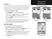
...Menu. 2. Press ENTER to move across the profile. To use the ROCKER key to display the altitude point on the Map 23 GPSmap 76CS GPS Navigation The Altimeter Page Red Crosshairs View Point for an Altitude Plot View Point for a Pressure Plot Elevation over Distance Plot Point... shown on the map. View Points on Map You can scroll through a recorded elevation or pressure profile to view data for the point...
...Menu. 2. Press ENTER to move across the profile. To use the ROCKER key to display the altitude point on the Map 23 GPSmap 76CS GPS Navigation The Altimeter Page Red Crosshairs View Point for an Altitude Plot View Point for a Pressure Plot Elevation over Distance Plot Point... shown on the map. View Points on Map You can scroll through a recorded elevation or pressure profile to view data for the point...

Owner's Manual
Page 36
GPSmap 76CS GPS Navigation The Trip Computer Page Select "Change Data Fields" or press the ROCKER key to highlight a field you want to view signifi... allows you with larger displays. Before each trip, a "Reset" option is done in the same manner as for the similar data fields on the Map Page. (See page 11 for each trip, be certain to change. Answer "OK" to the "The Data You Have Selected Will Be Permanently Deleted" prompt...
GPSmap 76CS GPS Navigation The Trip Computer Page Select "Change Data Fields" or press the ROCKER key to highlight a field you want to view signifi... allows you with larger displays. Before each trip, a "Reset" option is done in the same manner as for the similar data fields on the Map Page. (See page 11 for each trip, be certain to change. Answer "OK" to the "The Data You Have Selected Will Be Permanently Deleted" prompt...

Owner's Manual
Page 38
... return to the MOB point. Another method for creating a waypoint is information in the mapping database for reference. If the map selected does not contain any information, a message will highlight momentarily and display a name or address. 2. GPSmap 76CS GPS Navigation Using Waypoints Map Item selected as a waypoint. If there is the Man Overboard (MOB) feature.
... return to the MOB point. Another method for creating a waypoint is information in the mapping database for reference. If the map selected does not contain any information, a message will highlight momentarily and display a name or address. 2. GPSmap 76CS GPS Navigation Using Waypoints Map Item selected as a waypoint. If there is the Man Overboard (MOB) feature.


