Owner's Manual
Page 3
... system are a few non-GPS features such as the Calendar, Hunt and Fish, Sun and Moon and Games. GPS Navigation - i Preface Thank you have any difficulty while using your GPSmap 76CS. takes you through installing batteries, using our on the Home Page and follow instructions for choosing the Garmin GPSmap 76CS handheld navigation system. NOTE...
... system are a few non-GPS features such as the Calendar, Hunt and Fish, Sun and Moon and Games. GPS Navigation - i Preface Thank you have any difficulty while using your GPSmap 76CS. takes you through installing batteries, using our on the Home Page and follow instructions for choosing the Garmin GPSmap 76CS handheld navigation system. NOTE...

Owner's Manual
Page 7
...California's Proposition 65. WARNING: The Global Positioning System (GPS) is operated by the United States government, which could affect the accuracy and performance of California to us at http://www.garmin.com/ prop65. Although the Garmin GPSmap 76CS is solely responsible for its components contain chemicals known to... information, please refer to the consumer. WARNING: This product, its packaging, and its accuracy and maintenance. Virtually all GPS equipment. GPSmap 76CS Introduction Warnings and Precautions v The system is either not available or prohibitively expensive.
...California's Proposition 65. WARNING: The Global Positioning System (GPS) is operated by the United States government, which could affect the accuracy and performance of California to us at http://www.garmin.com/ prop65. Although the Garmin GPSmap 76CS is solely responsible for its components contain chemicals known to... information, please refer to the consumer. WARNING: This product, its packaging, and its accuracy and maintenance. Virtually all GPS equipment. GPSmap 76CS Introduction Warnings and Precautions v The system is either not available or prohibitively expensive.

Owner's Manual
Page 9
... Page 26Using Time Setup 66 Units Setup 66 Heading Setup 67 Calibration Setup 67 Altimeter Setup 68 Welcome Page Setup 69 ..... GPSmap 76CS Introduction Table of Contents Section 1: Introduction i-iv Waypoints 27 Preface i Using Find 31 Software License Agreement ii The Main Menu... 2: Getting Started 1-7 Battery Installation and Start Up 1 Key Functions 2 Unit Features 3 Initialization 4 The Satellite Page 4 Navigating with the GPSmap 76CS 5 The Main Page Sequence 6 The Main Page Features 7 The Setup Menu 57 System Setup 57 Display Setup 58 Interface Setup 58 Tones...
... Page 26Using Time Setup 66 Units Setup 66 Heading Setup 67 Calibration Setup 67 Altimeter Setup 68 Welcome Page Setup 69 ..... GPSmap 76CS Introduction Table of Contents Section 1: Introduction i-iv Waypoints 27 Preface i Using Find 31 Software License Agreement ii The Main Menu... 2: Getting Started 1-7 Battery Installation and Start Up 1 Key Functions 2 Unit Features 3 Initialization 4 The Satellite Page 4 Navigating with the GPSmap 76CS 5 The Main Page Sequence 6 The Main Page Features 7 The Setup Menu 57 System Setup 57 Display Setup 58 Interface Setup 58 Tones...

Owner's Manual
Page 10
GPSmap 76CS Introduction Table of Contents Section 4: GPS Features 71-79 Calendar 71 Alarm Clock 72 Calculator 72 Stopwatch 73 Sun and Moon Tables 74 Hunt and Fish Tables 75 GPS Enhanced Games 76 Non-Enhanced Game 79 Section 5: Appendix 80-98 Accessories 80 Specifcations 82 Data Field Definitions 84 Connecting the GPSmap 76CS to a Computer 89 Downloading MapSource Map Data 90 UTC Offset Chart 91 Map Datums and Position Formats 92 Loran TD Setup 93 WAAS and DGPS 94 Wiring Diagram 95 Index 96 Limited Warranty 99 viii
GPSmap 76CS Introduction Table of Contents Section 4: GPS Features 71-79 Calendar 71 Alarm Clock 72 Calculator 72 Stopwatch 73 Sun and Moon Tables 74 Hunt and Fish Tables 75 GPS Enhanced Games 76 Non-Enhanced Game 79 Section 5: Appendix 80-98 Accessories 80 Specifcations 82 Data Field Definitions 84 Connecting the GPSmap 76CS to a Computer 89 Downloading MapSource Map Data 90 UTC Offset Chart 91 Map Datums and Position Formats 92 Loran TD Setup 93 WAAS and DGPS 94 Wiring Diagram 95 Index 96 Limited Warranty 99 viii

Owner's Manual
Page 13
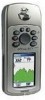
External Power and Data Connector Port (under weather cover) • Provides connection to a remote GPS antenna (MCX connector). Auxiliary GPS Antenna Connector (under weather cover) • Provides serial port interface to auto-install USB drivers incompatible with ... for detailed instructions. Refer to remove cover. IMPORTANT NOTE: Before connecting the unit to a PC for faster data transfer. GPSmap 76CS Getting Started Unit Features GPS Antenna (on front of unit) • Provides quick satellite acquisition. Carry Lanyard Attachment Slots 3 Battery Compartment Cover (weather ...
External Power and Data Connector Port (under weather cover) • Provides connection to a remote GPS antenna (MCX connector). Auxiliary GPS Antenna Connector (under weather cover) • Provides serial port interface to auto-install USB drivers incompatible with ... for detailed instructions. Refer to remove cover. IMPORTANT NOTE: Before connecting the unit to a PC for faster data transfer. GPSmap 76CS Getting Started Unit Features GPS Antenna (on front of unit) • Provides quick satellite acquisition. Carry Lanyard Attachment Slots 3 Battery Compartment Cover (weather ...
Owner's Manual
Page 14
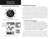
...receive satellite signals, you turn on the GPSmap 76CS, the GPS receiver begins to search for those satellites above its position Heading Bug indicates your unit. To initialize your position centered in order to each satellite. While the GPS receiver is searching for the satellite signals..." from your general location so the GPSmap 76CS can also observe a sky view array of the satellites overhead with your GPSmap 76CS: 1. A bar graph at the bottom of the page displays the strength of movement. Options Menu GPS Elevation display Satellite Page Acquiring Satellite Signals...
...receive satellite signals, you turn on the GPSmap 76CS, the GPS receiver begins to search for those satellites above its position Heading Bug indicates your unit. To initialize your position centered in order to each satellite. While the GPS receiver is searching for the satellite signals..." from your general location so the GPSmap 76CS can also observe a sky view array of the satellites overhead with your GPSmap 76CS: 1. A bar graph at the bottom of the page displays the strength of movement. Options Menu GPS Elevation display Satellite Page Acquiring Satellite Signals...
Owner's Manual
Page 15
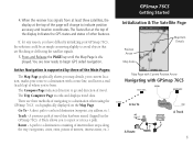
...address, etc.). Active Navigation is displayed. A Track allows you map details, your current location, marks your GPSmap 76CS, the solution could be as simple as moving slightly to begin GPS aided navigation. The Trip Computer Page records and displays travel that are now ready to avoid objects that has... been stored (logged) in the GPSmap 76CS. The Status Bar at the top of interest, intersections, etc...
...address, etc.). Active Navigation is displayed. A Track allows you map details, your current location, marks your GPSmap 76CS, the solution could be as simple as moving slightly to begin GPS aided navigation. The Trip Computer Page records and displays travel that are now ready to avoid objects that has... been stored (logged) in the GPSmap 76CS. The Status Bar at the top of interest, intersections, etc...
Owner's Manual
Page 18
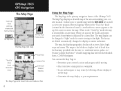
...your current location and progress while moving • Select and save a map point as rivers, lakes, highways and towns. residential streets, parks, etc.) because Garmin MapSource® detailed mapping data has been downloaded from a CD-ROM program. When in the "Track Up" mode (oriented in the direction of travel), ... for easier viewing in the "North Up" mode the map is the primary navigation feature of the area surrounding your progress when navigating. GPSmap 76CS GPS Navigation The Map Page "North Up" Mode with Map oriented with North at sunrise and sunset. When in dim light.
...your current location and progress while moving • Select and save a map point as rivers, lakes, highways and towns. residential streets, parks, etc.) because Garmin MapSource® detailed mapping data has been downloaded from a CD-ROM program. When in the "Track Up" mode (oriented in the direction of travel), ... for easier viewing in the "North Up" mode the map is the primary navigation feature of the area surrounding your progress when navigating. GPSmap 76CS GPS Navigation The Map Page "North Up" Mode with Map oriented with North at sunrise and sunset. When in dim light.

Owner's Manual
Page 19
... item highlighted on the map, also highlighted on the display screen. When using MapSource detailed maps, "mapsource" appears below the map scale. GPSmap 76CS GPS Navigation The Map Page Zoom In Zoom Out Map Features Map Scales Accuracy Circle Panning Arrow Guidance Text 9 The smaller the circle, the more.... If there are more detail. In many instances the map displays an "Accuracy Circle" surrounding the "Position Icon." The GPSmap 76CS uses both map resolution and GPS accuracy in order to show more map area with less detail or less map area with more than one map items under...
... item highlighted on the map, also highlighted on the display screen. When using MapSource detailed maps, "mapsource" appears below the map scale. GPSmap 76CS GPS Navigation The Map Page Zoom In Zoom Out Map Features Map Scales Accuracy Circle Panning Arrow Guidance Text 9 The smaller the circle, the more.... If there are more detail. In many instances the map displays an "Accuracy Circle" surrounding the "Position Icon." The GPSmap 76CS uses both map resolution and GPS accuracy in order to show more map area with less detail or less map area with more than one map items under...
Owner's Manual
Page 20
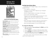
... displays items by selecting your own settings for navigation. Change Data Fields - Allows you want to use to the Map Pointer. Measure Distance - Restore Defaults - GPSmap 76CS GPS Navigation The Map Page The Map Page Options Menu A Quick Look at the top of the page showing Speed, Heading, Elevation and Time. Returns the...
... displays items by selecting your own settings for navigation. Change Data Fields - Allows you want to use to the Map Pointer. Measure Distance - Restore Defaults - GPSmap 76CS GPS Navigation The Map Page The Map Page Options Menu A Quick Look at the top of the page showing Speed, Heading, Elevation and Time. Returns the...
Owner's Manual
Page 21
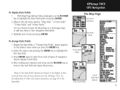
... next field and repeat the process. With Map Page Options Menu displayed, use the ROCKER key to move to display in that field. 4. GPSmap 76CS GPS Navigation The Map Page Data Field Sub-Menu Two Data Fields To change Data Fields: 1. Select this option and pressing the ENTER key to leave...
... next field and repeat the process. With Map Page Options Menu displayed, use the ROCKER key to move to display in that field. 4. GPSmap 76CS GPS Navigation The Map Page Data Field Sub-Menu Two Data Fields To change Data Fields: 1. Select this option and pressing the ENTER key to leave...

Owner's Manual
Page 22
...3. If you select "Always Show" and you useful information when using one of the Setup Options on page 5. GPSmap 76CS GPS Navigation The Map Page Guidance Text Options Menu GPS Status Message when not navigating To display Guidance Text: 1. If you select "Show When Navigating" a guidance message... will always be displayed until you are not navigating, the message field will display GPS Status information, To Setup the Map: Refer to display the Map Page Options Menu. 2. If you select "Always Show" a guidance message...
...3. If you select "Always Show" and you useful information when using one of the Setup Options on page 5. GPSmap 76CS GPS Navigation The Map Page Guidance Text Options Menu GPS Status Message when not navigating To display Guidance Text: 1. If you select "Show When Navigating" a guidance message... will always be displayed until you are not navigating, the message field will display GPS Status information, To Setup the Map: Refer to display the Map Page Options Menu. 2. If you select "Always Show" a guidance message...
Owner's Manual
Page 23
Access the Map Page Options Menu, select "Turn Declutter On" and press ENTER to activate. GPSmap 76CS GPS Navigation The Map Page Measured Distance The "Measure Distance" Option Enabled Map Declutter "Off" Map Declutter "On" 13 Turning Declutter On/Off This Map Page ...
Access the Map Page Options Menu, select "Turn Declutter On" and press ENTER to activate. GPSmap 76CS GPS Navigation The Map Page Measured Distance The "Measure Distance" Option Enabled Map Declutter "Off" Map Declutter "On" 13 Turning Declutter On/Off This Map Page ...
Owner's Manual
Page 24
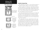
... guidance. The compass ring is On, a compass icon appears in progress, the Compass Page provides navigation data and directions. GPSmap 76CS GPS Navigation Using the Compass Page The Compass Page The Compass Ring moves to maintain your heading. The rotating compass ring indicates the direction you are ... of data displayed in conjunction with digital data fields to display information such as current speed, distance to your destination. You can choose from the GPS receiver to indicate North orientation.
... guidance. The compass ring is On, a compass icon appears in progress, the Compass Page provides navigation data and directions. GPSmap 76CS GPS Navigation Using the Compass Page The Compass Page The Compass Ring moves to maintain your heading. The rotating compass ring indicates the direction you are ... of data displayed in conjunction with digital data fields to display information such as current speed, distance to your destination. You can choose from the GPS receiver to indicate North orientation.
Owner's Manual
Page 25
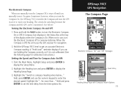
...press ENTER to get an accurate Electronic Compass reading. Hold the GPSmap 76CS level to display the Setup Menu. 2. Press and hold the PAGE button to turn the Compass On, the GPSmap 76CS overrides the Compass and uses the GPS receiver to track your heading. Highlight the "Switch to compass ... and Time for navigation. 2. Highlight the Heading icon and press ENTER to set the time delay from the time options list. GPSmap 76CS GPS Navigation The Compass Page Electronic Compass "On" and "Off" messages Speed Setting Time Delay Options Heading Setup Page with Compass Switch Options 15
...press ENTER to get an accurate Electronic Compass reading. Hold the GPSmap 76CS level to display the Setup Menu. 2. Press and hold the PAGE button to turn the Compass On, the GPSmap 76CS overrides the Compass and uses the GPS receiver to track your heading. Highlight the "Switch to compass ... and Time for navigation. 2. Highlight the Heading icon and press ENTER to set the time delay from the time options list. GPSmap 76CS GPS Navigation The Compass Page Electronic Compass "On" and "Off" messages Speed Setting Time Delay Options Heading Setup Page with Compass Switch Options 15

Owner's Manual
Page 26
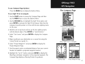
... adjust your turning speed as cars and buildings, etc. Remember to access the Options Menu. 2. If a "Calibration Failed" message displays, repeat the process. 4. GPSmap 76CS GPS Navigation The Compass Page Compass Calibration Page Calibration Progress Page 16 Calibrating the Electronic Compass The Electronic Compass must be calibrated outdoors when you to... the Compass Page. Use the PAGE button to access the Compass Page and then use the GPSmap 76CS and after new batteries have been installed. To Calibrate the Electronic Compass: 1.
... adjust your turning speed as cars and buildings, etc. Remember to access the Options Menu. 2. If a "Calibration Failed" message displays, repeat the process. 4. GPSmap 76CS GPS Navigation The Compass Page Compass Calibration Page Calibration Progress Page 16 Calibrating the Electronic Compass The Electronic Compass must be calibrated outdoors when you to... the Compass Page. Use the PAGE button to access the Compass Page and then use the GPSmap 76CS and after new batteries have been installed. To Calibrate the Electronic Compass: 1.
Owner's Manual
Page 27
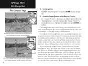
... sighting marks on a course line using the Course Pointer as a guide. Select "Set Course" and press ENTER to navigate Sighting Page Project Waypoint Page 17 GPSmap 76CS GPS Navigation The Compass Page Compass Page Options Menu Using "Sight 'N Go" to display the Compass Page. 5. Press ENTER to display the Project Waypoint Page. 7. Select...
... sighting marks on a course line using the Course Pointer as a guide. Select "Set Course" and press ENTER to navigate Sighting Page Project Waypoint Page 17 GPSmap 76CS GPS Navigation The Compass Page Compass Page Options Menu Using "Sight 'N Go" to display the Compass Page. 5. Press ENTER to display the Project Waypoint Page. 7. Select...
Owner's Manual
Page 28
... Pointer" is the factory set default option. Move to the right or left ) according to the scale displayed at the edge of the compass ring. GPSmap 76CS GPS Navigation The Compass Page The Bearing Pointer always indicates the direction to your destination from your current location. 0.25 mi Scale The Course Pointer indicates...
... Pointer" is the factory set default option. Move to the right or left ) according to the scale displayed at the edge of the compass ring. GPSmap 76CS GPS Navigation The Compass Page The Bearing Pointer always indicates the direction to your destination from your current location. 0.25 mi Scale The Course Pointer indicates...

Owner's Manual
Page 29
... Fields" option and press ENTER to change data fields: 1. Refer to place it in the fields displayed on the page will be highlighted. 2. GPSmap 76CS GPS Navigation The Compass Page Data Field Display Options Show 3 Data Fields Highlighted Data Field Show 4 Data Fields Course Pointer Option Data Field Option List 19...
... Fields" option and press ENTER to change data fields: 1. Refer to place it in the fields displayed on the page will be highlighted. 2. GPSmap 76CS GPS Navigation The Compass Page Data Field Display Options Show 3 Data Fields Highlighted Data Field Show 4 Data Fields Course Pointer Option Data Field Option List 19...
Owner's Manual
Page 30
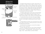
... current data. Page Options include: "Plot Over Time," "Plot Over Distance," "View Elevation Plot," "View Pressure Plot," "Zoom Ranges," "Reset," "Calibrate Altimeter" and "Restore Defaults." GPSmap 76CS GPS Navigation The Altimeter Page Range Grid Measurement Scale Selectable Data Fields Elevation Profile Plot over Distance Elevation Status Field Rate of Ascent/Descent...
... current data. Page Options include: "Plot Over Time," "Plot Over Distance," "View Elevation Plot," "View Pressure Plot," "Zoom Ranges," "Reset," "Calibrate Altimeter" and "Restore Defaults." GPSmap 76CS GPS Navigation The Altimeter Page Range Grid Measurement Scale Selectable Data Fields Elevation Profile Plot over Distance Elevation Status Field Rate of Ascent/Descent...


