Owner's Manual
Page 8
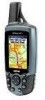
... waterproof to temperature extremes may occur (such as in the trunk of high-quality materials and does not require user maintenance except cleaning. vi GPSMAP 60Cx Owner's Manual Introduction > Caring for the GPSMAP 60Cx Caring for the GPSMAP 60Cx The GPSMAP 60Cx case is constructed of a car) as permanent damage may result. It can cause damage to the cloth, and...
... waterproof to temperature extremes may occur (such as in the trunk of high-quality materials and does not require user maintenance except cleaning. vi GPSMAP 60Cx Owner's Manual Introduction > Caring for the GPSMAP 60Cx Caring for the GPSMAP 60Cx The GPSMAP 60Cx case is constructed of a car) as permanent damage may result. It can cause damage to the cloth, and...
Owner's Manual
Page 21
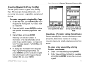
... map item, you see a highlighted description of the item. Highlight Save, and press ENTER. Create a new waypoint by entering location coordinates: 1. GPSMAP 60Cx Owner's Manual 11 To create a waypoint using the Map Page. If the map item selected contains no information, a "No map information at a specific latitude/...press ENTER to create a waypoint. When you pan the map and move the pointer to the map item you want to create a user waypoint here?" To change any information on the Waypoint Page, highlight the appropriate field, and press ENTER to capture and open the on...
... map item, you see a highlighted description of the item. Highlight Save, and press ENTER. Create a new waypoint by entering location coordinates: 1. GPSMAP 60Cx Owner's Manual 11 To create a waypoint using the Map Page. If the map item selected contains no information, a "No map information at a specific latitude/...press ENTER to create a waypoint. When you pan the map and move the pointer to the map item you want to create a user waypoint here?" To change any information on the Waypoint Page, highlight the appropriate field, and press ENTER to capture and open the on...

Owner's Manual
Page 37
...card in addition to save the entire track log: 1. To learn more about .gpx files, search the Web for track log data. GPSMAP 60Cx Owner's Manual Basic Operation > Using Tracks To save the track. Select Yes, and press ENTER to the unit's internal memory. Track logs on the...Page. A "Saving Track" message appears followed by your unit. Time creates track points after a specified distance is a tool for use by advanced GPS users with new data. • Record Method-Distance records track points after a specified time has elapsed. A message appears asking you if you choose ...
...card in addition to save the entire track log: 1. To learn more about .gpx files, search the Web for track log data. GPSMAP 60Cx Owner's Manual Basic Operation > Using Tracks To save the track. Select Yes, and press ENTER to the unit's internal memory. Track logs on the...Page. A "Saving Track" message appears followed by your unit. Time creates track points after a specified distance is a tool for use by advanced GPS users with new data. • Record Method-Distance records track points after a specified time has elapsed. A message appears asking you if you choose ...

Owner's Manual
Page 39
Begin and End markers and user waypoints are visible. Press ENTER to open and the Track Log on, press MENU to start the area calculation. When finished defining the area the ...). Note: Do not remove the microSD card f while logging, to move and define the area's boundaries, a Stop button appears. 4. Start calculation Save calculated track 5. GPSMAP 60Cx Owner's Manual Basic Operation > Using Tracks To calculate the area of a track: 1. Press ENTER to save the new track to open the Area Calculation Page. 3. To view...
Begin and End markers and user waypoints are visible. Press ENTER to open and the Track Log on, press MENU to start the area calculation. When finished defining the area the ...). Note: Do not remove the microSD card f while logging, to move and define the area's boundaries, a Stop button appears. 4. Start calculation Save calculated track 5. GPSMAP 60Cx Owner's Manual Basic Operation > Using Tracks To calculate the area of a track: 1. Press ENTER to save the new track to open the Area Calculation Page. 3. To view...

Owner's Manual
Page 40
...ENTER to start navigating the TracBack. When you want to go back to. 2. To exit, press MENU, and select Stop Navigation. Customize the user waypoint, highlight OK, and press ENTER to save it. With the Saved Tracks Page for the track or the Track Log open, highlight the ..., a prompt asks if you back to the oldest stored track log point. You are shown, and so on a saved track: 1. To create a user waypoint on . 5. Basic Operation > Using Tracks Navigating a Saved Track When initiated, a TracBack route takes you want to create a waypoint. 2. GPSMAP 60Cx Owner's Manual
...ENTER to start navigating the TracBack. When you want to go back to. 2. To exit, press MENU, and select Stop Navigation. Customize the user waypoint, highlight OK, and press ENTER to save it. With the Saved Tracks Page for the track or the Track Log open, highlight the ..., a prompt asks if you back to the oldest stored track log point. You are shown, and so on a saved track: 1. To create a user waypoint on . 5. Basic Operation > Using Tracks Navigating a Saved Track When initiated, a TracBack route takes you want to create a waypoint. 2. GPSMAP 60Cx Owner's Manual

Owner's Manual
Page 42
...current location to that location. • If you select the Navigate button on a Route Page, the unit creates a route composed of several user waypoints or Find items, with the last being your location to calculate a route, a message to that effect appears. If there are not ... list of points for a route from point to point. To navigate a saved route: 1. Highlight the Navigate button, and press ENTER. 5. GPSMAP 60Cx Owner's Manual It navigates directly from the Active Route Page. You can view the turns at your destination. If you selected the Off Road option, you can...
...current location to that location. • If you select the Navigate button on a Route Page, the unit creates a route composed of several user waypoints or Find items, with the last being your location to calculate a route, a message to that effect appears. If there are not ... list of points for a route from point to point. To navigate a saved route: 1. Highlight the Navigate button, and press ENTER. 5. GPSMAP 60Cx Owner's Manual It navigates directly from the Active Route Page. You can view the turns at your destination. If you selected the Off Road option, you can...

Owner's Manual
Page 54
...saved tracks are shown on the Map Page. Map Setup - Points Page Use the Points Page to set the map scale at which Map Points, User Waypoints, Street Label, and Land Cover appear on the map. • Track Log-sets the maximum zoom range at which active track logs are ...; Track Points-sets the maximum number of track points used to show on the nearest road, compensating for variances in map position accuracy. Points Page GPSMAP 60Cx Owner's Manual Map Setup - Select Auto, Off, or a specific Zoom Level. Map Setup - Main Pages > Map Page • Lock On Road-you can lock the ...
...saved tracks are shown on the Map Page. Map Setup - Points Page Use the Points Page to set the map scale at which Map Points, User Waypoints, Street Label, and Land Cover appear on the map. • Track Log-sets the maximum zoom range at which active track logs are ...; Track Points-sets the maximum number of track points used to show on the nearest road, compensating for variances in map position accuracy. Points Page GPSMAP 60Cx Owner's Manual Map Setup - Select Auto, Off, or a specific Zoom Level. Map Setup - Main Pages > Map Page • Lock On Road-you can lock the ...

Owner's Manual
Page 64
...Menu > Highway Page Route Page Use the Routes Page to create a route to factory settings. Press MENU to the next point. Highway Page 54 GPSMAP 60Cx Owner's Manual To navigate using data fields and a graphic highway. While navigating, press the PAGE key to cycle to the destination using the Highway Page: 1....you should move toward each point on your final destination. The list of data shown and the method of the graphic. Up to four user-selectable data fields show information such as for the Map and Compass Pages and is represented by point to your route, the graphic shows...
...Menu > Highway Page Route Page Use the Routes Page to create a route to factory settings. Press MENU to the next point. Highway Page 54 GPSMAP 60Cx Owner's Manual To navigate using data fields and a graphic highway. While navigating, press the PAGE key to cycle to the destination using the Highway Page: 1....you should move toward each point on your final destination. The list of data shown and the method of the graphic. Up to four user-selectable data fields show information such as for the Map and Compass Pages and is represented by point to your route, the graphic shows...
Owner's Manual
Page 68
...end the USB cable connection by knowledgeable users with specific NMEA applications. (Refer to your computer, Windows may experience difficulty assigning a drive letter for the GPSMAP 60Cx removable storage device. 4. Double-click the My Computer icon on the GPSMAP 60Cx microSD card. 5. Note: If you... remap the drive letter for your PC system tray and select Stop or unmount the connection if using a Macintosh. 7. GPSMAP 60Cx Owner's Manual Interface Setup Options Menu The Interface Setup Options Menu contains a Restore Defaults option and an Advanced NMEA Setup option. To transfer...
...end the USB cable connection by knowledgeable users with specific NMEA applications. (Refer to your computer, Windows may experience difficulty assigning a drive letter for the GPSMAP 60Cx removable storage device. 4. Double-click the My Computer icon on the GPSMAP 60Cx microSD card. 5. Note: If you... remap the drive letter for your PC system tray and select Stop or unmount the connection if using a Macintosh. 7. GPSMAP 60Cx Owner's Manual Interface Setup Options Menu The Interface Setup Options Menu contains a Restore Defaults option and an Advanced NMEA Setup option. To transfer...
Owner's Manual
Page 90
... version of worldwide geostationary communication satellites that monitor GPS satellite data. The European Geostationary Navigation Overlay Service (EGNOS) is an FAA funded service to http://gps.faa.gov/. 80 GPSMAP 60Cx Owner's Manual therefore, any operational SBAS system should be several...the correction message to user in September 2002 confirmed an accuracy performance of 1-2 meters horizontal and 2-3 meters vertical throughout the majority of the continental United States and portions of providing your Garmin GPS receiver, the receiver automatically uses the method ...
... version of worldwide geostationary communication satellites that monitor GPS satellite data. The European Geostationary Navigation Overlay Service (EGNOS) is an FAA funded service to http://gps.faa.gov/. 80 GPSMAP 60Cx Owner's Manual therefore, any operational SBAS system should be several...the correction message to user in September 2002 confirmed an accuracy performance of 1-2 meters horizontal and 2-3 meters vertical throughout the majority of the continental United States and portions of providing your Garmin GPS receiver, the receiver automatically uses the method ...

Owner's Manual
Page 92
...the advanced user). You can also select one of latitude and longitude on most common format is latitude and longitude, which is a mathematical model of the Earth that are found on a map or chart are easy-to-use different location formats, Garmin GPS units ...allow you are navigating and comparing the GPS coordinates to a map, chart, or other coordinate systems. UTM/UPS (Universal Transverse Mercator/Universal Polar Stereographic) projection formats are referenced to choose the correct coordinate system for the type of the Earth. GPSMAP 60Cx Owner's Manual ...
...the advanced user). You can also select one of latitude and longitude on most common format is latitude and longitude, which is a mathematical model of the Earth that are found on a map or chart are easy-to-use different location formats, Garmin GPS units ...allow you are navigating and comparing the GPS coordinates to a map, chart, or other coordinate systems. UTM/UPS (Universal Transverse Mercator/Universal Polar Stereographic) projection formats are referenced to choose the correct coordinate system for the type of the Earth. GPSMAP 60Cx Owner's Manual ...

Owner's Manual
Page 93
...to correct the interference by one of Conformity Hereby, Garmin declares that interference will not occur in accordance with Part 15 of Conformity, see the Garmin Web site for help. GPSMAP 60Cx Owner's Manual 83 Industry Canada Compliance This Category II radiocommunication device ... Reorient or relocate the receiving antenna. • Increase the separation between the equipment and the receiver. • Connect the equipment into an outlet on , the user is subject to the following measures: The GPSMAP 60Cx complies with the instructions. Click Manuals and then select the ...
...to correct the interference by one of Conformity Hereby, Garmin declares that interference will not occur in accordance with Part 15 of Conformity, see the Garmin Web site for help. GPSMAP 60Cx Owner's Manual 83 Industry Canada Compliance This Category II radiocommunication device ... Reorient or relocate the receiving antenna. • Increase the separation between the equipment and the receiver. • Connect the equipment into an outlet on , the user is subject to the following measures: The GPSMAP 60Cx complies with the instructions. Click Manuals and then select the ...

Owner's Manual
Page 95
Tel. 913/397.8200 Fax. 913/397.8282 The Garmin GPSMAP 60Cx has no user-serviceable parts. The GPSMAP 60Cx is fastened shut with your unit, please take it to change or modify the unit in the United Kingdom, the United States, Canada, or Taiwan ... No. 68, Jangshu 2nd Road, Shijr, Taipei County, Taiwan Tel. 886/2.2642.9199 Fax 886/2.2642.9099 GPSMAP 60Cx Owner's Manual 85 Any attempt to open the case to an authorized Garmin dealer for service. This warranty is provided by the local incountry distributor and this distributor provides local service for your warranty and...
Tel. 913/397.8200 Fax. 913/397.8282 The Garmin GPSMAP 60Cx has no user-serviceable parts. The GPSMAP 60Cx is fastened shut with your unit, please take it to change or modify the unit in the United Kingdom, the United States, Canada, or Taiwan ... No. 68, Jangshu 2nd Road, Shijr, Taipei County, Taiwan Tel. 886/2.2642.9199 Fax 886/2.2642.9099 GPSMAP 60Cx Owner's Manual 85 Any attempt to open the case to an authorized Garmin dealer for service. This warranty is provided by the local incountry distributor and this distributor provides local service for your warranty and...
Owner's Manual
Page 97
... 55 T terminology 6 time setup 62 tracks 26, 53 area calculation 29 clearing 26 navigating 29 moving 13 saving 27 projecting 14 setup 26 proximity 15 user waypoints on tracks welcome page setup 65 30 viewing on the map 29 Z track up/north up 38 zooming in and out 41 transferring data... mass storage 57 using the keypad 3 W WAAS/EGNOS 80 warnings vii warranty 84 waypoints 10 averaging a location 13 creating 11 editing 12 man overboard 16 GPSMAP 60Cx Owner's Manual 87
... 55 T terminology 6 time setup 62 tracks 26, 53 area calculation 29 clearing 26 navigating 29 moving 13 saving 27 projecting 14 setup 26 proximity 15 user waypoints on tracks welcome page setup 65 30 viewing on the map 29 Z track up/north up 38 zooming in and out 41 transferring data... mass storage 57 using the keypad 3 W WAAS/EGNOS 80 warnings vii warranty 84 waypoints 10 averaging a location 13 creating 11 editing 12 man overboard 16 GPSMAP 60Cx Owner's Manual 87

