
Owner's Manual
Page 15
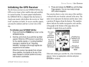
... message until the Map Page appears. Press and release the PAGE key until enough signals are now ready to turn on your GPSMAP 60CSx, the GPS receiver must be outdoors and have a clear view of the sky. The numbers shown indicate the number assigned to fix its current ...can also observe a sky view array of the page changes to indicate position accuracy and location coordinates. The inner circle is shipped from the horizon. Initializing the GPS Receiver The first time you turn on Earth. GPSMAP 60CSx Owner's Manual Getting Started > Unit Overview 3. You are acquired to each ...
... message until the Map Page appears. Press and release the PAGE key until enough signals are now ready to turn on your GPSMAP 60CSx, the GPS receiver must be outdoors and have a clear view of the sky. The numbers shown indicate the number assigned to fix its current ...can also observe a sky view array of the page changes to indicate position accuracy and location coordinates. The inner circle is shipped from the horizon. Initializing the GPS Receiver The first time you turn on Earth. GPSMAP 60CSx Owner's Manual Getting Started > Unit Overview 3. You are acquired to each ...

Owner's Manual
Page 24
...Waypoints icon, and press ENTER to open the Waypoints Page. 14 Enter bearing and distance Project Waypoint Page Projected waypoint on the map GPSMAP 60CSx Owner's Manual To project a waypoint: 1. Press MENU to open the Options menu. 5. Enter the distance and bearing to open the... Project Waypoint Page. 6. They should be taking averages of the page, and press QUIT when finished. 3. Observe the Estimated Accuracy and Measurement Count fields. Basic Operation > Basic Operation Waypoint options 3. The Waypoint Page opens. 4. Press FIND to the projected waypoint...
...Waypoints icon, and press ENTER to open the Waypoints Page. 14 Enter bearing and distance Project Waypoint Page Projected waypoint on the map GPSMAP 60CSx Owner's Manual To project a waypoint: 1. Press MENU to open the Options menu. 5. Enter the distance and bearing to open the... Project Waypoint Page. 6. They should be taking averages of the page, and press QUIT when finished. 3. Observe the Estimated Accuracy and Measurement Count fields. Basic Operation > Basic Operation Waypoint options 3. The Waypoint Page opens. 4. Press FIND to the projected waypoint...
Owner's Manual
Page 54
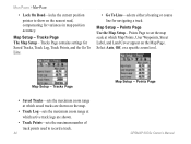
... Tracks, Track Log, Track Points, and the Go To Line. • Go To Line-selects either a bearing or course line for variances in map position accuracy. Points Page GPSMAP 60CSx Owner's Manual
... Tracks, Track Log, Track Points, and the Go To Line. • Go To Line-selects either a bearing or course line for variances in map position accuracy. Points Page GPSMAP 60CSx Owner's Manual

Owner's Manual
Page 60
..." message appears, repeat the process. 4. Use the numeric keypad to open the Compass Page Options menu. 2. GPSMAP 60CSx Owner's Manual Highlight the for holding and turning the unit. The accuracy of the compass is also affected if the unit is not held level or you are near objects that affect... magnetic fields, such as needed. To ensure continued accuracy, calibrate after installing new batteries, after moving more than 68º F (20º C). Press ENTER to return to open the Calibration Page...
..." message appears, repeat the process. 4. Use the numeric keypad to open the Compass Page Options menu. 2. GPSMAP 60CSx Owner's Manual Highlight the for holding and turning the unit. The accuracy of the compass is also affected if the unit is not held level or you are near objects that affect... magnetic fields, such as needed. To ensure continued accuracy, calibrate after installing new batteries, after moving more than 68º F (20º C). Press ENTER to return to open the Calibration Page...

Owner's Manual
Page 66
Main Pages > Altimeter Page You can increase the accuracy of the altimeter using the "Calibrate Altimeter" option. • Restore Defaults-clears recorded data from the Altimeter Page Options Menu. Altimeter Page Options Use the ... elevation for your location, you can configure the Profile field in the center of the page to show the View Elevation Plot over a distance. 56 GPSMAP 60CSx Owner's Manual
Main Pages > Altimeter Page You can increase the accuracy of the altimeter using the "Calibrate Altimeter" option. • Restore Defaults-clears recorded data from the Altimeter Page Options Menu. Altimeter Page Options Use the ... elevation for your location, you can configure the Profile field in the center of the page to show the View Elevation Plot over a distance. 56 GPSMAP 60CSx Owner's Manual
Owner's Manual
Page 71
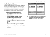
... Altimeter, and press ENTER to open the Altimeter Page Options Menu. 2. You must know the elevation, select No to use the default GPS elevation. Main Pages > Altimeter Page 4. OR If you do not know the elevation or pressure at any given elevation can fluctuate, you... calibrate the altimeter to increase its accuracy. Use the ROCKER to enter the new elevation or pressure, then highlight OK and press ENTER to return to the Altimeter Page. To manually calibrate the altimeter: 1. Calibrating the Altimeter Because the GPSMAP 60CSx relies on the barometric pressure to determine...
... Altimeter, and press ENTER to open the Altimeter Page Options Menu. 2. You must know the elevation, select No to use the default GPS elevation. Main Pages > Altimeter Page 4. OR If you do not know the elevation or pressure at any given elevation can fluctuate, you... calibrate the altimeter to increase its accuracy. Use the ROCKER to enter the new elevation or pressure, then highlight OK and press ENTER to return to the Altimeter Page. To manually calibrate the altimeter: 1. Calibrating the Altimeter Because the GPSMAP 60CSx relies on the barometric pressure to determine...
Owner's Manual
Page 85
...: (for more than)-sets speed and time delay for increased accuracy in navigation. Follow the instructions on page 61. See page 49. To calibrate the compass: 1. To calibrate the Altimeter: Highlight Altimeter and press ENTER to open the Compass Calibration Page. GPSMAP 60CSx Owner's Manual 75 Main Menu > Heading Setup - Follow the instructions...
...: (for more than)-sets speed and time delay for increased accuracy in navigation. Follow the instructions on page 61. See page 49. To calibrate the compass: 1. To calibrate the Altimeter: Highlight Altimeter and press ENTER to open the Compass Calibration Page. GPSMAP 60CSx Owner's Manual 75 Main Menu > Heading Setup - Follow the instructions...
Owner's Manual
Page 87
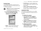
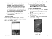
... as an elevation entered from a known source, but is sufficient for most navigation applications. 2. The accuracy varies depending on your welcome message, and press ENTER. 2. Welcome Setup Use the Welcome Setup Page to enter your GPSMAP 60CSx. Allow the GPS Receiver to close. 3. To add a welcome message: 1. Main Menu > Welcome Setup To access the Welcome...
... as an elevation entered from a known source, but is sufficient for most navigation applications. 2. The accuracy varies depending on your welcome message, and press ENTER. 2. Welcome Setup Use the Welcome Setup Page to enter your GPSMAP 60CSx. Allow the GPS Receiver to close. 3. To add a welcome message: 1. Main Menu > Welcome Setup To access the Welcome...
Owner's Manual
Page 101
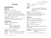
...receiver with backlighting. Appendix > Specifications Appendix Specifications Physical Size: 6.1" H x 2.4" W x 1.3" D Weight: 7.5 ounces (213 g) w/batteries installed. Case: Rugged, fully gasketed, water resistant, IEC-529, IPX7 Temp Range: 5 to 158oF (-15 to proper user calibration. Compass: Accuracy; +/- 5 degrees1, resolution; 1 degree Altimeter: Accuracy; +/- 10 feet*, resolution; 1 ft. *Subject to 70oC)* *The temperature rating of the GPSMAP 60CSx.... Display:1.5" W x 2.2" H, 256-color, high resolution, transreflective (160 x 240 pixels) with an open sky view. Accuracy GPS:
...receiver with backlighting. Appendix > Specifications Appendix Specifications Physical Size: 6.1" H x 2.4" W x 1.3" D Weight: 7.5 ounces (213 g) w/batteries installed. Case: Rugged, fully gasketed, water resistant, IEC-529, IPX7 Temp Range: 5 to 158oF (-15 to proper user calibration. Compass: Accuracy; +/- 5 degrees1, resolution; 1 degree Altimeter: Accuracy; +/- 10 feet*, resolution; 1 ft. *Subject to 70oC)* *The temperature rating of the GPSMAP 60CSx.... Display:1.5" W x 2.2" H, 256-color, high resolution, transreflective (160 x 240 pixels) with an open sky view. Accuracy GPS:

Owner's Manual
Page 103
... mean sea level. Heading-your direction of arrival at your starting point to the end of travel as latitude and longitude coordinates. GPSMAP 60CSx Owner's Manual 93 Accuracy Of GPS-the current accuracy of measure (other than latitude and longitude). Ascent - Ascent - Distance - Descent-Average-the vertical distance of ascent. Descent - To Next-the distance...
... mean sea level. Heading-your direction of arrival at your starting point to the end of travel as latitude and longitude coordinates. GPSMAP 60CSx Owner's Manual 93 Accuracy Of GPS-the current accuracy of measure (other than latitude and longitude). Ascent - Ascent - Distance - Descent-Average-the vertical distance of ascent. Descent - To Next-the distance...

Owner's Manual
Page 107
Master stations, located on your GPSMAP 60CSx in North America. Master station uplinks the correction message to http://gps.faa.gov/Programs/WAAS/waas.htm. augmentation systems (SBAS). Currently, enabling WAAS on your Garmin GPS receiver, the receiver automatically uses the method that are not supported by ground stations may not improve accuracy, even when receiving signals from the reference...
Master stations, located on your GPSMAP 60CSx in North America. Master station uplinks the correction message to http://gps.faa.gov/Programs/WAAS/waas.htm. augmentation systems (SBAS). Currently, enabling WAAS on your Garmin GPS receiver, the receiver automatically uses the method that are not supported by ground stations may not improve accuracy, even when receiving signals from the reference...
Quick Reference Guide
Page 2
... the GPSMAP 60CSx by searching for satellites that may be found molded into the battery compartment. Status Bar 3D GPS indicator Received Satellite icon Satellite Page Options • Turn GPS Off • Orient display to mark your location • GPS Elevation Overhead Satellite not yet received Satellite signal strength bars Satellite Page Displays your location coordinates, position accuracy...
... the GPSMAP 60CSx by searching for satellites that may be found molded into the battery compartment. Status Bar 3D GPS indicator Received Satellite icon Satellite Page Options • Turn GPS Off • Orient display to mark your location • GPS Elevation Overhead Satellite not yet received Satellite signal strength bars Satellite Page Displays your location coordinates, position accuracy...
