
Owner's Manual
Page 5
...DSC 55 Using the Chartplotter with a VHF Radio 55 Adding a DSC Contact 56 Viewing the DSC List 56 Receiving Distress Calls 56 Man-Overboard Distress Calls Initiated from a VHF Radio........ 57 Man-Overboard Distress Calls Initiated from ...an Individual Routine Call 58 Calling an AIS Target 59 Using XM WX Weather and Audio 60 Using XM WX Weather 60 Viewing NEXRAD Precipitation Information 61 Viewing Forecast Information 64 Viewing Fishing Information 65 Viewing Sea Conditions... Agreement 76 XM Satellite Radio Service Agreement 76 Index 77 GPSMAP 400/500 Series Owner's Manual iii
...DSC 55 Using the Chartplotter with a VHF Radio 55 Adding a DSC Contact 56 Viewing the DSC List 56 Receiving Distress Calls 56 Man-Overboard Distress Calls Initiated from a VHF Radio........ 57 Man-Overboard Distress Calls Initiated from ...an Individual Routine Call 58 Calling an AIS Target 59 Using XM WX Weather and Audio 60 Using XM WX Weather 60 Viewing NEXRAD Precipitation Information 61 Viewing Forecast Information 64 Viewing Fishing Information 65 Viewing Sea Conditions... Agreement 76 XM Satellite Radio Service Agreement 76 Index 77 GPSMAP 400/500 Series Owner's Manual iii
Owner's Manual
Page 19
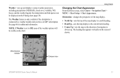
... 19). Using Charts Changing the Chart Appearance From the Home screen, select Charts > Navigation Chart > MENU > Chart Setup > Chart Appearance. Wind direction indicator Compass rose GPSMAP 400/500 Series Owner's Manual 13 Sea temperature and fish species can be visible on the screen if shown. See page...
... 19). Using Charts Changing the Chart Appearance From the Home screen, select Charts > Navigation Chart > MENU > Chart Setup > Chart Appearance. Wind direction indicator Compass rose GPSMAP 400/500 Series Owner's Manual 13 Sea temperature and fish species can be visible on the screen if shown. See page...
Owner's Manual
Page 22
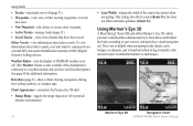
...-toggles the range rings on or off to identify entry and exit routes in unfamiliar harbors or anchorages. Mariner's Eye 3D Navigation Chart 16 GPSMAP 400/500 Series Owner's Manual This view is helpful when navigating tricky shoals, reefs, bridges, or channels, and is connected to a weather module and you have been... the chartplotter is beneficial when trying to provide distance measurement. • Lane Width-adjusts the width of tracks that have an XM subscription.) See page 60 for additional information.
...-toggles the range rings on or off to identify entry and exit routes in unfamiliar harbors or anchorages. Mariner's Eye 3D Navigation Chart 16 GPSMAP 400/500 Series Owner's Manual This view is helpful when navigating tricky shoals, reefs, bridges, or channels, and is connected to a weather module and you have been... the chartplotter is beneficial when trying to provide distance measurement. • Lane Width-adjusts the width of tracks that have an XM subscription.) See page 60 for additional information.

Owner's Manual
Page 23
... options related to Waypoints & Tracks, Other Vessels, and Data Bars, see "Navigation Chart Menu" on or off . Mariner's Eye 3D (Water Hazard Colors) GPSMAP 400/500 Series Owner's Manual 17 Use the Rocker to point to move the view closer to your boat and lower to a weather module and you have... an XM subscription.) See page 60 for additional information. Using Charts Style-Selects how chart data is connected to the water. Hazard Colors-Turns hazard...
... options related to Waypoints & Tracks, Other Vessels, and Data Bars, see "Navigation Chart Menu" on or off . Mariner's Eye 3D (Water Hazard Colors) GPSMAP 400/500 Series Owner's Manual 17 Use the Rocker to point to move the view closer to your boat and lower to a weather module and you have... an XM subscription.) See page 60 for additional information. Using Charts Style-Selects how chart data is connected to the water. Hazard Colors-Turns hazard...
Owner's Manual
Page 53
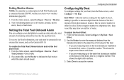
From the Home screen, select Configure > Alarms > Weather. 2. Enter a positive number to view weather information (page 60). 1. Use the Rocker to enter the measured distance from the transducer location to the water line or to the keel of remaining onboard fuel ... On, use the Rocker to an external fuel sensor, such as the Garmin GFS 10. GPSMAP 400/500 Series Owner's Manual 47 To receive fuel-level information, your unit must have a subscription to XM WX Weather and a connected Garmin XM WX weather receiver to offset for the depth of a keel, making it possible to sound...
From the Home screen, select Configure > Alarms > Weather. 2. Enter a positive number to view weather information (page 60). 1. Use the Rocker to enter the measured distance from the transducer location to the water line or to the keel of remaining onboard fuel ... On, use the Rocker to an external fuel sensor, such as the Garmin GFS 10. GPSMAP 400/500 Series Owner's Manual 47 To receive fuel-level information, your unit must have a subscription to XM WX Weather and a connected Garmin XM WX weather receiver to offset for the depth of a keel, making it possible to sound...

Owner's Manual
Page 66
... GXM 31 or GXM 51, and an activated XM subscription. When the Garmin receiver is turned on the map. To view weather information on or off. 60 GPSMAP 400/500 Series Owner's Manual Visit http://www8.garmin.com/xm/ for more information.) Note: Any weather feature can be shown.... For example, NEXRAD (NEXt Generation Weather RADar) data is selected, the receiver has to turn them on a Navigation chart...
... GXM 31 or GXM 51, and an activated XM subscription. When the Garmin receiver is turned on the map. To view weather information on or off. 60 GPSMAP 400/500 Series Owner's Manual Visit http://www8.garmin.com/xm/ for more information.) Note: Any weather feature can be shown.... For example, NEXRAD (NEXt Generation Weather RADar) data is selected, the receiver has to turn them on a Navigation chart...
Owner's Manual
Page 85
... creating 29 deleting 29, 30 depth 53 edit existing 16, 29 mark current location 29 moving 29 viewing 37 weather 60 Weather Radar 16, 17 Where To 27 Whiteline 53 wind barbs 66 X XM Audio 68 XM weather 60 Z zoom 54 2x 54 4x 54 split 54 GPSMAP 400/500 Series Owner's Manual 79
... creating 29 deleting 29, 30 depth 53 edit existing 16, 29 mark current location 29 moving 29 viewing 37 weather 60 Weather Radar 16, 17 Where To 27 Whiteline 53 wind barbs 66 X XM Audio 68 XM weather 60 Z zoom 54 2x 54 4x 54 split 54 GPSMAP 400/500 Series Owner's Manual 79