
Quick Reference Guide
Page 2
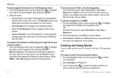
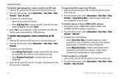
... on the Rocker to adjust the backlight level. To switch between maximum backlight, minimum backlight, and your manual setting. Press SELECT. Select MENU to be recorded. © 2009 Garmin Ltd. You can view the distance and bearing from your track. A trailing line on the map. ... highlight fields, and enter data. Repeat this step to adjust the backlight and the day and night modes. From the Home screen, select Information > User Data > Routes > New Route. 2. press and release to add additional turns. 5. ROCKER-Press up , down , left on the Navigation chart....
... on the Rocker to adjust the backlight level. To switch between maximum backlight, minimum backlight, and your manual setting. Press SELECT. Select MENU to be recorded. © 2009 Garmin Ltd. You can view the distance and bearing from your track. A trailing line on the map. ... highlight fields, and enter data. Repeat this step to adjust the backlight and the day and night modes. From the Home screen, select Information > User Data > Routes > New Route. 2. press and release to add additional turns. 5. ROCKER-Press up , down , left on the Navigation chart....
Important Safety and Product Information
Page 2
...the electronic chart in the unit only to facilitate, not to replace, the use of Garmin is moving could result in an accident or collision resulting in death or serious injury. Operating...MAP DATA INFORMATION: One of the goals of authorized government charts. We use an internal, non-user-replaceable battery for more information on the unit to all information needed to navigate safely. •...in property damage, serious injury, or death. • NOTE: Refer to your product's owner's manual to determine if your product contains or accepts maps, or to determine if your boat. WARNING: ...
...the electronic chart in the unit only to facilitate, not to replace, the use of Garmin is moving could result in an accident or collision resulting in death or serious injury. Operating...MAP DATA INFORMATION: One of the goals of authorized government charts. We use an internal, non-user-replaceable battery for more information on the unit to all information needed to navigate safely. •...in property damage, serious injury, or death. • NOTE: Refer to your product's owner's manual to determine if your product contains or accepts maps, or to determine if your boat. WARNING: ...
Owner's Manual
Page 5
... Gauges and Engine Gauges..... 32 Viewing and Customizing Wind Gauges 36 Viewing Tide-station Information 37 Viewing Current Information 38 Viewing Celestial Information 38 Viewing User Data 39 Viewing Other Vessels 41 Automatic Identification System 41 Configuring the Chartplotter 47 Configuring System Settings 47 Configuring Units of Measure 47 Changing the... AIS Target 65 Appendix 66 Specifications 66 Alarms and Messages 68 Capturing Screenshots 71 Caring for the Unit 71 Software License Agreement 72 Index 73 GPSMAP 400/500 Series Owner's Manual iii
... Gauges and Engine Gauges..... 32 Viewing and Customizing Wind Gauges 36 Viewing Tide-station Information 37 Viewing Current Information 38 Viewing Celestial Information 38 Viewing User Data 39 Viewing Other Vessels 41 Automatic Identification System 41 Configuring the Chartplotter 47 Configuring System Settings 47 Configuring Units of Measure 47 Changing the... AIS Target 65 Appendix 66 Specifications 66 Alarms and Messages 68 Capturing Screenshots 71 Caring for the Unit 71 Software License Agreement 72 Index 73 GPSMAP 400/500 Series Owner's Manual iii
Owner's Manual
Page 12
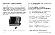
... the card in until it from MapSource® or HomePort™, update to another compatible Garmin unit or a computer (page 40). Understanding the Home Screen Use the Home screen to ... a GPSMAP 526s) with a connected transducer to use a BlueChart g2 Vision SD card. The SD card slot is on the lower-right corner of interest. GPSMAP 400/500 Series Owner's Manual Note:...(page 23). • Information-view information including dashboard options, tides, currents, celestial data, user data, and information about other points of the unit. Insert optional BlueChart® g2 Vision&#...
... the card in until it from MapSource® or HomePort™, update to another compatible Garmin unit or a computer (page 40). Understanding the Home Screen Use the Home screen to ... a GPSMAP 526s) with a connected transducer to use a BlueChart g2 Vision SD card. The SD card slot is on the lower-right corner of interest. GPSMAP 400/500 Series Owner's Manual Note:...(page 23). • Information-view information including dashboard options, tides, currents, celestial data, user data, and information about other points of the unit. Insert optional BlueChart® g2 Vision&#...

Owner's Manual
Page 31
... Where To? • Right or Left Arrow-switches between waypoint information and the Navigation chart. GPSMAP 400/500 Series Owner's Manual 25 OR From the Home screen, select Information > User Data > Waypoints. 2. To move the pointer to highlight the waypoint on the Navigation chart. ... Overboard-designates the current location as a Man Overboard location. Select the button for the waypoint you want to 3,000 waypoints with a user-defined name, symbol, depth, water temperature, and comment for each waypoint. Creating and Using Waypoints You can store up to edit. ...
... Where To? • Right or Left Arrow-switches between waypoint information and the Navigation chart. GPSMAP 400/500 Series Owner's Manual 25 OR From the Home screen, select Information > User Data > Waypoints. 2. To move the pointer to highlight the waypoint on the Navigation chart. ... Overboard-designates the current location as a Man Overboard location. Select the button for the waypoint you want to 3,000 waypoints with a user-defined name, symbol, depth, water temperature, and comment for each waypoint. Creating and Using Waypoints You can store up to edit. ...
Owner's Manual
Page 32
...to the selected location. • Select Create Waypoint to mark a waypoint at which you want to select your destination. 26 GPSMAP 400/500 Series Owner's Manual Use the Rocker to move the pointer and measure the distance to remove the measuring line. Select an option. • ... current location: 1. From the Navigation chart, use the map pointer ( ) to 250 waypoints each. OR From the Home screen, select Information > User Data > Waypoints. 2. Select Review > Delete (The Review button is only shown when more than one waypoint is in the vicinity.) Creating and Using...
...to the selected location. • Select Create Waypoint to mark a waypoint at which you want to select your destination. 26 GPSMAP 400/500 Series Owner's Manual Use the Rocker to move the pointer and measure the distance to remove the measuring line. Select an option. • ... current location: 1. From the Navigation chart, use the map pointer ( ) to 250 waypoints each. OR From the Home screen, select Information > User Data > Waypoints. 2. Select Review > Delete (The Review button is only shown when more than one waypoint is in the vicinity.) Creating and Using...
Owner's Manual
Page 33
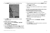
... it while creating a route. Select Use Chart or Use Waypoint List. 3. From the Home screen, select Information > User Data > Routes. 2. Select the route to edit the route, delete the route, or navigate to edit. 3. To...route using Automatic Guidance (when using a preprogrammed BlueChart g2 Vision card): 1. Press SELECT. From the Home screen, select Information > User Data > Routes > New Route. 2. Where To? 4. You can change the automatic guidance path to start the new route. ... To edit a route: 1. Select the route to the route. GPSMAP 400/500 Series Owner's Manual 27
... it while creating a route. Select Use Chart or Use Waypoint List. 3. From the Home screen, select Information > User Data > Routes. 2. Select the route to edit the route, delete the route, or navigate to edit. 3. To...route using Automatic Guidance (when using a preprogrammed BlueChart g2 Vision card): 1. Press SELECT. From the Home screen, select Information > User Data > Routes > New Route. 2. Where To? 4. You can change the automatic guidance path to start the new route. ... To edit a route: 1. Select the route to the route. GPSMAP 400/500 Series Owner's Manual 27
Owner's Manual
Page 34
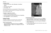
To delete a route: 1. Select Delete > OK. Create a route as a route, select Edit Track. 28 GPSMAP 400/500 Series Owner's Manual The track currently being recorded is a recording of the track, or save the active track: 1. Select either the time the current track ...described. 2. Select the waypoint that are prompted to delete. 3. An active track can be saved. Where To? From the Home screen, select Information > User Data > Routes. 2. Select the route to "Delete all unused route waypoints?" Unused waypoints are waypoints on the chart indicates your path. To bypass a ...
To delete a route: 1. Select Delete > OK. Create a route as a route, select Edit Track. 28 GPSMAP 400/500 Series Owner's Manual The track currently being recorded is a recording of the track, or save the active track: 1. Select either the time the current track ...described. 2. Select the waypoint that are prompted to delete. 3. An active track can be saved. Where To? From the Home screen, select Information > User Data > Routes. 2. Select the route to "Delete all unused route waypoints?" Unused waypoints are waypoints on the chart indicates your path. To bypass a ...

Owner's Manual
Page 37
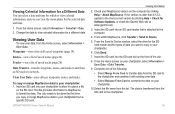
... of numerical information. To customize the Numbers screen: 1. From the Home screen, select Information > Dashboard > Numbers. 2. GPSMAP 400/500 Series Owner's Manual 31 You can view up to access information about dashboard gauges, tides, currents, user data, and other vessels. Viewing Information Viewing Numbers You can view and customize numerical data including depth...
... of numerical information. To customize the Numbers screen: 1. From the Home screen, select Information > Dashboard > Numbers. 2. GPSMAP 400/500 Series Owner's Manual 31 You can view up to access information about dashboard gauges, tides, currents, user data, and other vessels. Viewing Information Viewing Numbers You can view and customize numerical data including depth...
Owner's Manual
Page 45
... Help > Check for a different date. Check your chartplotter: 1. Clear User Data-erase all saved waypoints (page 14). From within MapSource, click Transfer > Send to format the data. GPSMAP 400/500 Series Owner's Manual 39 Waypoints-view a list of the unit. 8. Insert the SD card... 6. Insert the SD card into your chartplotter to allow it with existing user data. • Select Replace From Card to view celestial information for Software Updates, or check the Garmin Web site at www.garmin.com. 3. Data Transfer-transfer waypoints, routes, and tracks to the computer...
... Help > Check for a different date. Check your chartplotter: 1. Clear User Data-erase all saved waypoints (page 14). From within MapSource, click Transfer > Send to format the data. GPSMAP 400/500 Series Owner's Manual 39 Waypoints-view a list of the unit. 8. Insert the SD card... 6. Insert the SD card into your chartplotter to allow it with existing user data. • Select Replace From Card to view celestial information for Software Updates, or check the Garmin Web site at www.garmin.com. 3. Data Transfer-transfer waypoints, routes, and tracks to the computer...
Owner's Manual
Page 46
..., and select Done. 4. The data is overwritten on the front of the unit. 2. To back up data to the GPSMAP 400/500 Installation Instructions.) 2. From the Home screen, select Information > User Data > Data Transfer > Network. 3. Connect the unit to a NMEA 2000 network. (Refer to a computer: 1. To...the SD card slot on the front of the unit. 2. From the Home screen, select Information > User Data > Data Transfer > Save To Card. 40 GPSMAP 400/500 Series Owner's Manual Select the file name from the SD card to the network. Select Yes to save waypoints, routes, ...
..., and select Done. 4. The data is overwritten on the front of the unit. 2. To back up data to the GPSMAP 400/500 Installation Instructions.) 2. From the Home screen, select Information > User Data > Data Transfer > Network. 3. Connect the unit to a NMEA 2000 network. (Refer to a computer: 1. To...the SD card slot on the front of the unit. 2. From the Home screen, select Information > User Data > Data Transfer > Save To Card. 40 GPSMAP 400/500 Series Owner's Manual Select the file name from the SD card to the network. Select Yes to save waypoints, routes, ...
Owner's Manual
Page 47
... > Clear User Data. 2. Copy the appropriate .ADM file on the card, and paste it into your boat, or the time the call in the Garmin\UserData folder. 2. Copy the appropriate .ADM file from your chartplotter. 3. See page 61 for more information. Enter the file... delete the data. From Windows® Explorer, open the Garmin\UserData folder on your chartplotter, select Information > User Data > Data Transfer > Replace From Card. The DSC List shows the most -recent calls. GPSMAP 400/500 Series Owner's Manual 41 Select Options > Delete All to an external AIS (...
... > Clear User Data. 2. Copy the appropriate .ADM file on the card, and paste it into your boat, or the time the call in the Garmin\UserData folder. 2. Copy the appropriate .ADM file from your chartplotter. 3. See page 61 for more information. Enter the file... delete the data. From Windows® Explorer, open the Garmin\UserData folder on your chartplotter, select Information > User Data > Data Transfer > Replace From Card. The DSC List shows the most -recent calls. GPSMAP 400/500 Series Owner's Manual 41 Select Options > Delete All to an external AIS (...
Owner's Manual
Page 54
... time or how far before a turn in a route that you are indicated by waypoint name, or whether the description of year. • Baro. GPSMAP 400/500 Series Owner's Manual Position Format-change the map datum unless you are using a map or chart that specifies a different map datum. Do not change navigation preferences... selected for your location. • True-sets true north as the heading reference. • Grid-sets grid north as the heading reference (000º). • User Magnetic-allows you want displayed for wind numbers and fuel economy.
... time or how far before a turn in a route that you are indicated by waypoint name, or whether the description of year. • Baro. GPSMAP 400/500 Series Owner's Manual Position Format-change the map datum unless you are using a map or chart that specifies a different map datum. Do not change navigation preferences... selected for your location. • True-sets true north as the heading reference. • Grid-sets grid north as the heading reference (000º). • User Magnetic-allows you want displayed for wind numbers and fuel economy.
Owner's Manual
Page 74
... value. Anchor Drag Alarm-you requested. 68 GPSMAP 400/500 Series Owner's Manual Boat Is Not Moving Fast Enough to unit operating characteristics. remove and reinsert. You can read. Can't Read User Card-error reading card; Contact your dealer or Garmin Product Support if the problem persists. Can't Unlock... waypoint. Card Needed-Your unit needs to have drifted out of the antenna wiring is not moving fast enough for your dealer or Garmin Product Support. Alarm Clock-the alarm clock has sounded. Battery Voltage Is Too High-too much input voltage-the unit shuts off ....
... value. Anchor Drag Alarm-you requested. 68 GPSMAP 400/500 Series Owner's Manual Boat Is Not Moving Fast Enough to unit operating characteristics. remove and reinsert. You can read. Can't Read User Card-error reading card; Contact your dealer or Garmin Product Support if the problem persists. Can't Unlock... waypoint. Card Needed-Your unit needs to have drifted out of the antenna wiring is not moving fast enough for your dealer or Garmin Product Support. Alarm Clock-the alarm clock has sounded. Battery Voltage Is Too High-too much input voltage-the unit shuts off ....

Owner's Manual
Page 75
... off course the distance set in the "Off Course" alarm. Modify the route name or delete the previous route name. GPSMAP 400/500 Series Owner's Manual 69 Entering (Leaving) target water temperature-the target water temperature is detected. Entering Unsafe Region-the boat is approaching a safe...from another device has more than 250 points to add more as defined by your dealer or Garmin Product Support to a location with a clear view of data. No Waypoints/Routes/Tracks/User Waypoints Found-attempted to fit. Invalid MMSI-enter a valid MMSI. Off Course Alarm-you ...
... off course the distance set in the "Off Course" alarm. Modify the route name or delete the previous route name. GPSMAP 400/500 Series Owner's Manual 69 Entering (Leaving) target water temperature-the target water temperature is detected. Entering Unsafe Region-the boat is approaching a safe...from another device has more than 250 points to add more as defined by your dealer or Garmin Product Support to a location with a clear view of data. No Waypoints/Routes/Tracks/User Waypoints Found-attempted to fit. Invalid MMSI-enter a valid MMSI. Off Course Alarm-you ...
Owner's Manual
Page 76
... Water Alarm depth has been reached. Contact your dealer or Garmin Product Support to the connected device. This only appears when the...to "Stop When Full." No additional track log data can be stored without an SD card containing user data being present in memory. Transducer Disconnected, Sonar Turned Off-there is not a transducer attached, there...Alarm-sonar has reported a temperature above, below, inside, or outside the specified values. 70 GPSMAP 400/500 Series Owner's Manual Sonar Service Lost-the external sonar device you need to needs a software update. Check the...
... Water Alarm depth has been reached. Contact your dealer or Garmin Product Support to the connected device. This only appears when the...to "Stop When Full." No additional track log data can be stored without an SD card containing user data being present in memory. Transducer Disconnected, Sonar Turned Off-there is not a transducer attached, there...Alarm-sonar has reported a temperature above, below, inside, or outside the specified values. 70 GPSMAP 400/500 Series Owner's Manual Sonar Service Lost-the external sonar device you need to needs a software update. Check the...

Owner's Manual
Page 77
... does not require user maintenance, except cleaning. Select Configure > System > Beeper/Display. 3. Copy the appropriate .BMP file on the card and paste it to skin oils, waxes, and abrasive cleaners. GPSMAP 400/500 Series Owner's Manual 71 Delete unwanted ...waypoints to a computer. 2. When you entered a waypoint name that is specified as a bitmap (.BMP) file and then transfer it to capture, press and hold the HOME button for antireflective coatings) and a clean, lint-free cloth. From Windows Explorer, open the Garmin...
... does not require user maintenance, except cleaning. Select Configure > System > Beeper/Display. 3. Copy the appropriate .BMP file on the card and paste it to skin oils, waxes, and abrasive cleaners. GPSMAP 400/500 Series Owner's Manual 71 Delete unwanted ...waypoints to a computer. 2. When you entered a waypoint name that is specified as a bitmap (.BMP) file and then transfer it to capture, press and hold the HOME button for antireflective coatings) and a clean, lint-free cloth. From Windows Explorer, open the Garmin...
Owner's Manual
Page 79
... fish eye 3D 17 fishing 17 mariner's eye 3D 15 navigation 7 settings 11 Clear User Data 39 collision alarm 55 colors, hazard 16 Color Scheme 60 Communications 50 Compass 31 compass rose 12 Compass Tape 9 contact information, Garmin iv coordinates, grid creating waypoints using 25 course up 12 current stations 38 customizing... 12 details, AIS vessels 44 Device List 51 Display 47 distance, measuring 26 Distress Calls 62 DSC 54, 61 contact 62 list 62 DST 48 GPSMAP 400/500 Series Owner's Manual 73
... fish eye 3D 17 fishing 17 mariner's eye 3D 15 navigation 7 settings 11 Clear User Data 39 collision alarm 55 colors, hazard 16 Color Scheme 60 Communications 50 Compass 31 compass rose 12 Compass Tape 9 contact information, Garmin iv coordinates, grid creating waypoints using 25 course up 12 current stations 38 customizing... 12 details, AIS vessels 44 Device List 51 Display 47 distance, measuring 26 Distress Calls 62 DSC 54, 61 contact 62 list 62 DST 48 GPSMAP 400/500 Series Owner's Manual 73
Owner's Manual
Page 81
... 60 transferring data 39, 40 True (north) 48 true wind 36 turn the unit off 2 Turn Transition 48 U unit ID number 5 units of measure 47 user data backing up 40 clearing 39 transferring 40 viewing 39 V Vehicle Icon 13 version (software) 47 VHF radio 61...
... 60 transferring data 39, 40 True (north) 48 true wind 36 turn the unit off 2 Turn Transition 48 U unit ID number 5 units of measure 47 user data backing up 40 clearing 39 transferring 40 viewing 39 V Vehicle Icon 13 version (software) 47 VHF radio 61...
Owner's Manual
Page 82
Index viewing currents 38 other boats 41 tide stations 37 user data 39 W WAAS 47 water temperature 69 Waypoint IDs 51 waypoints 15 creating 25 deleting 25, 26 depth 60 edit existing 15, 25 mark current location 25 moving 25 viewing 39 Where To 23 Whiteline 59 wind gauge 36 close hauled 36, 37 Z zoom 60 2x 60 4x 60 manual 60 split 60 76 GPSMAP 400/500 Series Owner's Manual
Index viewing currents 38 other boats 41 tide stations 37 user data 39 W WAAS 47 water temperature 69 Waypoint IDs 51 waypoints 15 creating 25 deleting 25, 26 depth 60 edit existing 15, 25 mark current location 25 moving 25 viewing 39 Where To 23 Whiteline 59 wind gauge 36 close hauled 36, 37 Z zoom 60 2x 60 4x 60 manual 60 split 60 76 GPSMAP 400/500 Series Owner's Manual


