Owner's Manual
Page 13
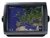
... can pan away from your current location and to scroll to other areas on the point you touched. • Touch Review to view details of objects in vicinity of the cursor. (Review does not appear if the cursor is not near an object-if the cursor is displayed in the upper-left... of the screen so you can keep track of your boat's current location. Touch and drag the Navigation screen to the selected location (page 8). GPSMAP 5000 Series Owner...
... can pan away from your current location and to scroll to other areas on the point you touched. • Touch Review to view details of objects in vicinity of the cursor. (Review does not appear if the cursor is not near an object-if the cursor is displayed in the upper-left... of the screen so you can keep track of your boat's current location. Touch and drag the Navigation screen to the selected location (page 8). GPSMAP 5000 Series Owner...
Owner's Manual
Page 14
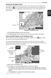
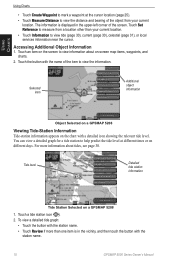
.... For more than your current location. Tide level Detailed tide station information Tide Station Selected on the chart with the station name. 10 GPSMAP 5000 Series Owner's Manual Touch Set Reference to measure from your current location. • Touch Information to help predict the tide level at...of the item to view the information. To view a detailed tide graph: • Touch the button with the station name. • Touch Review if more information about on different days. Touch an item on the screen to view information about tides, see page 30. Using Charts Using Charts...
.... For more than your current location. Tide level Detailed tide station information Tide Station Selected on the chart with the station name. 10 GPSMAP 5000 Series Owner's Manual Touch Set Reference to measure from your current location. • Touch Information to help predict the tide level at...of the item to view the information. To view a detailed tide graph: • Touch the button with the station name. • Touch Review if more information about on different days. Touch an item on the screen to view information about tides, see page 30. Using Charts Using Charts...
Owner's Manual
Page 23
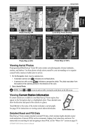
...The photo was taken from the location of the camera, pointed in and out while viewing the aerial photo on page 23. Select Aerial Photo. GPSMAP 5000 Series Owner's Manual 19 Current Station icon Detailed Road and POI Data BlueChart g2 Vision contains detailed road and POI data, which includes highly... see the "Where To?" Using Charts Using Charts Photo Overlay Off Land Only Photo Overlay Photo Map at 50% Photo Map at a glance. Touch Review or the name of many landmarks, marinas, and harbors. See page 30 for and navigating to these photos to help orient yourself to zoom in...
...The photo was taken from the location of the camera, pointed in and out while viewing the aerial photo on page 23. Select Aerial Photo. GPSMAP 5000 Series Owner's Manual 19 Current Station icon Detailed Road and POI Data BlueChart g2 Vision contains detailed road and POI data, which includes highly... see the "Where To?" Using Charts Using Charts Photo Overlay Off Land Only Photo Overlay Photo Map at 50% Photo Map at a glance. Touch Review or the name of many landmarks, marinas, and harbors. See page 30 for and navigating to these photos to help orient yourself to zoom in...
Owner's Manual
Page 30
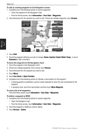
... one of the following actions to edit. If there are multiple waypoints in the vicinity, touch Review. 3. Where To? 3. If there are multiple waypoints, touch Review. Touch Move. 5. To delete a waypoint or MOB: 1. Touch Review > Delete. 26 GPSMAP 5000 Series Owner's Manual To move the waypoint on the Navigation screen: 1. To view a list of...
... one of the following actions to edit. If there are multiple waypoints in the vicinity, touch Review. 3. Where To? 3. If there are multiple waypoints, touch Review. Touch Move. 5. To delete a waypoint or MOB: 1. Touch Review > Delete. 26 GPSMAP 5000 Series Owner's Manual To move the waypoint on the Navigation screen: 1. To view a list of...
Owner's Manual
Page 33
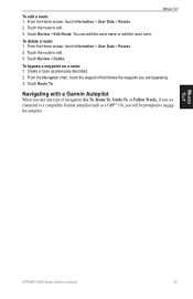
Touch Review > Edit Route. From the Home screen, touch Information > User Data > Routes. 2. Navigating with a Garmin Autopilot When you start any type of navigation (Go To, Route To, Guide To, or Follow Track), if you are bypassing. 3. From the... chart, touch the waypoint that follows the waypoint you will be prompted to a compatible Garmin autopilot (such as previously described. 2. Touch Review > Delete. To bypass a waypoint on a route: 1. Touch Route To. Touch the route to edit. 3. GPSMAP 5000 Series Owner's Manual 29 To edit a route: 1. You can edit the route...
Touch Review > Edit Route. From the Home screen, touch Information > User Data > Routes. 2. Navigating with a Garmin Autopilot When you start any type of navigation (Go To, Route To, Guide To, or Follow Track), if you are bypassing. 3. From the... chart, touch the waypoint that follows the waypoint you will be prompted to a compatible Garmin autopilot (such as previously described. 2. Touch Review > Delete. To bypass a waypoint on a route: 1. Touch Route To. Touch the route to edit. 3. GPSMAP 5000 Series Owner's Manual 29 To edit a route: 1. You can edit the route...
Owner's Manual
Page 42
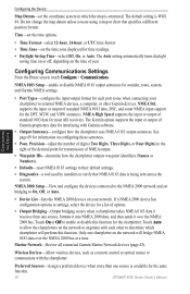
...perform this function for the same function. 38 GPSMAP 5000 Series Owner's Manual NMEA 2000 Setup-View and configure the devices connected to the NMEA 2000 network and set bridging to enable or disable this function. Marine Network-Review all connected Garmin Marine Network devices (page 43). Configuring the Device ... the NMEA 2000 devices on the time of options. • Output Bridging-Output bridging occurs when a chartplotter takes NMEA 0183 data it receives from any source, formats it into NMEA 2000 data, and then sends it over the NMEA 2000 bus at a time. The default setting...
...perform this function for the same function. 38 GPSMAP 5000 Series Owner's Manual NMEA 2000 Setup-View and configure the devices connected to the NMEA 2000 network and set bridging to enable or disable this function. Marine Network-Review all connected Garmin Marine Network devices (page 43). Configuring the Device ... the NMEA 2000 devices on the time of options. • Output Bridging-Output bridging occurs when a chartplotter takes NMEA 0183 data it receives from any source, formats it into NMEA 2000 data, and then sends it over the NMEA 2000 bus at a time. The default setting...
Owner's Manual
Page 48
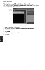
Each connected device is listed along the left side of the devices: 1. From the Home screen, touch Configure > Communications > Marine Network. 2. Use the on-screen keyboard to one of the screen. Touch the button for the device. 3. Touch Done. Touch Review. 4. No name defined Name defined Network Devices To assign a name to name the device. 5. Using the Marine Network Viewing Connected Garmin Marine Network Devices From the Home screen, touch Configure > Communications > Marine Network. Marine Network 44 GPSMAP 5000 Series Owner's Manual
Each connected device is listed along the left side of the devices: 1. From the Home screen, touch Configure > Communications > Marine Network. 2. Use the on-screen keyboard to one of the screen. Touch the button for the device. 3. Touch Done. Touch Review. 4. No name defined Name defined Network Devices To assign a name to name the device. 5. Using the Marine Network Viewing Connected Garmin Marine Network Devices From the Home screen, touch Configure > Communications > Marine Network. Marine Network 44 GPSMAP 5000 Series Owner's Manual
Owner's Manual
Page 60
...man-overboard point. Man-Overboard Distress Calls Initiated from the following options: • Select Call with the call is sent. DSC 56 GPSMAP 5000 Series Owner's Manual Digital Selective Calling Viewing the DSC List The DSC list is a log of the most -recent call . The...58). Touch Review to view details about the call from a boat. Man-Overboard Distress Calls Initiated from a VHF Radio When your Garmin chartplotter and VHF radio are using NMEA 0183 or NMEA 2000, your VHF radio receives a DSC distress call. Receiving Distress Calls If your Garmin chartplotter is ...
...man-overboard point. Man-Overboard Distress Calls Initiated from the following options: • Select Call with the call is sent. DSC 56 GPSMAP 5000 Series Owner's Manual Digital Selective Calling Viewing the DSC List The DSC list is a log of the most -recent call . The...58). Touch Review to view details about the call from a boat. Man-Overboard Distress Calls Initiated from a VHF Radio When your Garmin chartplotter and VHF radio are using NMEA 0183 or NMEA 2000, your VHF radio receives a DSC distress call. Receiving Distress Calls If your Garmin chartplotter is ...
Owner's Manual
Page 61
..., see your Garmin VHF Radio Owner's Manual. This feature is logged in the DSC list (page 34). Every position report call received is also available...of the vessel, and a Blue Flag symbol indicating the last reported position. GPSMAP 5000 Series Owner's Manual 57 To view a list of hours to edit...Garmin NMEA 2000-compatible VHF radio. • Select Edit to show or hide the trail line for each reported position, a black line indicating the path of displayed trail points: 1. Digital Selective Calling For information on placing distress calls from the list, and then select Review...
..., see your Garmin VHF Radio Owner's Manual. This feature is logged in the DSC list (page 34). Every position report call received is also available...of the vessel, and a Blue Flag symbol indicating the last reported position. GPSMAP 5000 Series Owner's Manual 57 To view a list of hours to edit...Garmin NMEA 2000-compatible VHF radio. • Select Edit to show or hide the trail line for each reported position, a black line indicating the path of displayed trail points: 1. Digital Selective Calling For information on placing distress calls from the list, and then select Review...

Owner's Manual
Page 62
... transmits this request with your Garmin chartplotter to a Garmin VHF NMEA 2000-compatible radio, you call from that vessel from the list, and then touch Review. 3. If you want to set up an individual routine call : 1. For more information on which you select a different channel, the chartplotter will not receive call from the list...
... transmits this request with your Garmin chartplotter to a Garmin VHF NMEA 2000-compatible radio, you call from that vessel from the list, and then touch Review. 3. If you want to set up an individual routine call : 1. For more information on which you select a different channel, the chartplotter will not receive call from the list...
Owner's Manual
Page 81
... R radar 45 cross talk 49 fast time constant 49 overlay screen 48 surface 13 range rings 13 rear panel 1 reset 4 review 26 rings 11, 50 Roses 11 routes cancel 27 creating 27 deleting 29 editing 29 route to 23 S safe depth 13, ... 32 visibility 64 Vision BlueChart g2 15 volume unit settings 37 VRM/EBL adjusting 49 W warm front 62 warnings county 61 marine 61 warranty 74 water speed (calibrate) 40 temperature 64 wave direction 62 height 63 period 62 waypoints 13 creating 10, 25... devices 38 X XM audio 42, 59, 66 XM weather 59 Z zoom 6, 12, 17, 19, 54 Index GPSMAP 5000 Series Owner's Manual 77
... R radar 45 cross talk 49 fast time constant 49 overlay screen 48 surface 13 range rings 13 rear panel 1 reset 4 review 26 rings 11, 50 Roses 11 routes cancel 27 creating 27 deleting 29 editing 29 route to 23 S safe depth 13, ... 32 visibility 64 Vision BlueChart g2 15 volume unit settings 37 VRM/EBL adjusting 49 W warm front 62 warnings county 61 marine 61 warranty 74 water speed (calibrate) 40 temperature 64 wave direction 62 height 63 period 62 waypoints 13 creating 10, 25... devices 38 X XM audio 42, 59, 66 XM weather 59 Z zoom 6, 12, 17, 19, 54 Index GPSMAP 5000 Series Owner's Manual 77
Quick Reference Guide
Page 1
...GPSMAP® 5000 Series quick reference guide List of the 50 nearest locations and the distance and bearing to each. 3. From the Home screen, touch Charts > Navigation Chart. 2. Navigation Chart Editing or Deleting a Waypoint To edit a waypoint: 1. Navigation Chart Go to the destination. ) marks the point. Touch the marine...Create Waypoint. Touch Edit to the destination. Touch the point on the chart: 1. Touch Review > Delete. The chartplotter shows the list of Marine Service Items Go to Destination Navigating to a Destination on the Chart To navigate to a ...
...GPSMAP® 5000 Series quick reference guide List of the 50 nearest locations and the distance and bearing to each. 3. From the Home screen, touch Charts > Navigation Chart. 2. Navigation Chart Editing or Deleting a Waypoint To edit a waypoint: 1. Navigation Chart Go to the destination. ) marks the point. Touch the marine...Create Waypoint. Touch Edit to the destination. Touch the point on the chart: 1. Touch Review > Delete. The chartplotter shows the list of Marine Service Items Go to Destination Navigating to a Destination on the Chart To navigate to a ...
Quick Reference Guide
Page 2
...screen, touch Information > User Data > Waypoints. 2. Touch the MOB location you want to turn off the chartplotter: 1. Touch Review > Edit Route. MOB locations are trademarks of Garmin. Complete one of combination screens. • Touch Layout to change screen combinations: 1. Touch your present location: 1. Touch the...of the first turn. 5. From the Home screen, touch Charts > Navigation Chart. 2. When the warning screen appears, touch I Agree. Garmin®, the Gamin logo, GPSMAP®, BlueChart®, and g2 Vision® are marked with the symbol. 3.
...screen, touch Information > User Data > Waypoints. 2. Touch the MOB location you want to turn off the chartplotter: 1. Touch Review > Edit Route. MOB locations are trademarks of Garmin. Complete one of combination screens. • Touch Layout to change screen combinations: 1. Touch your present location: 1. Touch the...of the first turn. 5. From the Home screen, touch Charts > Navigation Chart. 2. When the warning screen appears, touch I Agree. Garmin®, the Gamin logo, GPSMAP®, BlueChart®, and g2 Vision® are marked with the symbol. 3.