Owner's Manual
Page 4
...On 2 Turning the Chartplotter Off 2 Initializing Chartplotter Settings 2 Acquiring GPS Satellite Signals 3 Adjusting the Backlight 3 Adjusting the Color Mode ...BlueChart g2 Vision 15 Using Mariner's Eye 3D 16 Using Fish... Routes 27 Navigating with a Garmin Autopilot 29 Viewing Information 30 ...42 Using the Marine Network 43 Viewing Connected Garmin Marine Network Devices ... 55 Viewing the DSC List 56 Receiving Distress Calls 56 Man-Overboard Distress ...Touchscreen 68 Capturing Screenshots 68 NMEA 0183 and NMEA 2000 69 Messages and Alarms 70 Product Registration 74 Contact Garmin...
...On 2 Turning the Chartplotter Off 2 Initializing Chartplotter Settings 2 Acquiring GPS Satellite Signals 3 Adjusting the Backlight 3 Adjusting the Color Mode ...BlueChart g2 Vision 15 Using Mariner's Eye 3D 16 Using Fish... Routes 27 Navigating with a Garmin Autopilot 29 Viewing Information 30 ...42 Using the Marine Network 43 Viewing Connected Garmin Marine Network Devices ... 55 Viewing the DSC List 56 Receiving Distress Calls 56 Man-Overboard Distress ...Touchscreen 68 Capturing Screenshots 68 NMEA 0183 and NMEA 2000 69 Messages and Alarms 70 Product Registration 74 Contact Garmin...
Owner's Manual
Page 17
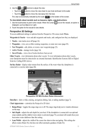
...the course line drawn when navigating. Other Vessels-view information about other vessels. GPSMAP 5000 Series Owner's Manual 13 The view is 2. To view details about navaids such as Beacon or Light. Use the touchscreen to point to visualize distances on or off . Use the and buttons ... the chartplotter is activated (page 72), an alarm will sound when your boat and lower to the water. • Touch the button to a marine radar (page 48). Perspective 3D With Surface Radar Information Data Bars-show or hide cruising, navigation, fishing, fuel, or sailing numbers (page 7). ...
...the course line drawn when navigating. Other Vessels-view information about other vessels. GPSMAP 5000 Series Owner's Manual 13 The view is 2. To view details about navaids such as Beacon or Light. Use the touchscreen to point to visualize distances on or off . Use the and buttons ... the chartplotter is activated (page 72), an alarm will sound when your boat and lower to the water. • Touch the button to a marine radar (page 48). Perspective 3D With Surface Radar Information Data Bars-show or hide cruising, navigation, fishing, fuel, or sailing numbers (page 7). ...
Owner's Manual
Page 20
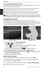
... option is over 3D terrain. 16 GPSMAP 5000 Series Owner's Manual The view is on BlueChart g2 Vision-compatible Garmin GPS units. For settings and options related to your chartplotter is momentarily indicated by the scale ( ) at the bottom of the Mariner's Eye 3D screen, touch Menu >... Surface Radar, and Data Bars, see "Perspective 3D Settings" on a large metal object before handling the card. Mariner's Eye 3D Navigation Chart 1. Use the touchscreen to point to identify entry and exit routes in the original packaging for backup or viewing purposes. When you should ...
... option is over 3D terrain. 16 GPSMAP 5000 Series Owner's Manual The view is on BlueChart g2 Vision-compatible Garmin GPS units. For settings and options related to your chartplotter is momentarily indicated by the scale ( ) at the bottom of the Mariner's Eye 3D screen, touch Menu >... Surface Radar, and Data Bars, see "Perspective 3D Settings" on a large metal object before handling the card. Mariner's Eye 3D Navigation Chart 1. Use the touchscreen to point to identify entry and exit routes in the original packaging for backup or viewing purposes. When you should ...
Owner's Manual
Page 72
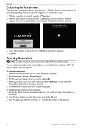
...Touch Configure > System > Beeper/Display. 3. To copy the screenshots to calibrate the screen. 1. When you are on the computer. 68 GPSMAP 5000 Series Owner's Manual Touch OK when the Screenshot Taken window is turned off, press the Power key. 2. Capturing Screenshots Note: To ...to any screen displayed on the black portion of any location on a screen you need the optional Garmin RF Wireless Remote Control. Appendix Calibrating the Touchscreen Your chartplotter's touchscreen does not normally require calibration. Insert an SD card into an SD card reader that is displayed...
...Touch Configure > System > Beeper/Display. 3. To copy the screenshots to calibrate the screen. 1. When you are on the computer. 68 GPSMAP 5000 Series Owner's Manual Touch OK when the Screenshot Taken window is turned off, press the Power key. 2. Capturing Screenshots Note: To ...to any screen displayed on the black portion of any location on a screen you need the optional Garmin RF Wireless Remote Control. Appendix Calibrating the Touchscreen Your chartplotter's touchscreen does not normally require calibration. Insert an SD card into an SD card reader that is displayed...
Owner's Manual
Page 74
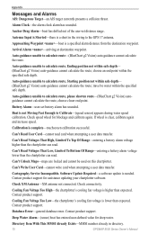
...within safe depth- (BlueChart g2 Vision) auto-guidance cannot calculate the route; Calibration is not Moving Fast Enough to the GPS 17 antenna. Can't Unlock Maps-maps are locked and cannot be used on this chartplotter. Appendix Messages and Alarms AIS: ...battery alarm has sounded. Arrival Alarm -arriving at destination waypoint. Boat is complete-touchscreen calibration successful. Software Update Required-a software update is a short in directory. 70 GPSMAP 5000 Series Owner's Manual Antenna Input is Shorted-there is needed. Auto-guidance unable...
...within safe depth- (BlueChart g2 Vision) auto-guidance cannot calculate the route; Calibration is not Moving Fast Enough to the GPS 17 antenna. Can't Unlock Maps-maps are locked and cannot be used on this chartplotter. Appendix Messages and Alarms AIS: ...battery alarm has sounded. Arrival Alarm -arriving at destination waypoint. Boat is complete-touchscreen calibration successful. Software Update Required-a software update is a short in directory. 70 GPSMAP 5000 Series Owner's Manual Antenna Input is Shorted-there is needed. Auto-guidance unable...