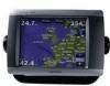
Owner's Manual
Page 4
... Off 2 Initializing Chartplotter Settings 2 Acquiring GPS Satellite Signals 3 Adjusting the Backlight 3 ...Garmin Marine Network Devices 44 Using Radar 45 Using Cruising Mode 46 Using Sentry Mode 46 Radar Targeting 47 Understanding the Radar Overlay Screen 48 Obtaining Optimal Radar Display Performance.......49 Adjusting the VRM and EBL 49 Configuring Other Vessels on the Radar Screen.....50 Advanced Radar Configuration 50...Garmin 74 Declaration of Conformity (DoC 74 Weather Data Warranty 74 Software License Agreement 75 XM Satellite Radio Service Agreement 75 Index 76 GPSMAP...
... Off 2 Initializing Chartplotter Settings 2 Acquiring GPS Satellite Signals 3 Adjusting the Backlight 3 ...Garmin Marine Network Devices 44 Using Radar 45 Using Cruising Mode 46 Using Sentry Mode 46 Radar Targeting 47 Understanding the Radar Overlay Screen 48 Obtaining Optimal Radar Display Performance.......49 Adjusting the VRM and EBL 49 Configuring Other Vessels on the Radar Screen.....50 Advanced Radar Configuration 50...Garmin 74 Declaration of Conformity (DoC 74 Weather Data Warranty 74 Software License Agreement 75 XM Satellite Radio Service Agreement 75 Index 76 GPSMAP...
Owner's Manual
Page 81
... screen 48 surface 13 range rings 13 rear panel 1 reset 4 review 26 rings 11, 50 Roses 11 routes cancel 27 creating 27 deleting 29 editing 29 route to 23 S safe depth...Service Points 11 settings chart 11 communications 38 severe thunderstorm warning 61 simulator mode 4, 36 software version 4 sonar 51 A-scope 53 advanced settings 53 depth line 53 gain 54 range... volume unit settings 37 VRM/EBL adjusting 49 W warm front 62 warnings county 61 marine 61 warranty 74 water speed (calibrate) 40 temperature 64 wave direction 62 height 63 ...zoom 6, 12, 17, 19, 54 Index GPSMAP 5000 Series Owner's Manual 77
... screen 48 surface 13 range rings 13 rear panel 1 reset 4 review 26 rings 11, 50 Roses 11 routes cancel 27 creating 27 deleting 29 editing 29 route to 23 S safe depth...Service Points 11 settings chart 11 communications 38 severe thunderstorm warning 61 simulator mode 4, 36 software version 4 sonar 51 A-scope 53 advanced settings 53 depth line 53 gain 54 range... volume unit settings 37 VRM/EBL adjusting 49 W warm front 62 warnings county 61 marine 61 warranty 74 water speed (calibrate) 40 temperature 64 wave direction 62 height 63 ...zoom 6, 12, 17, 19, 54 Index GPSMAP 5000 Series Owner's Manual 77
Remote Instructions (Multilingual)
Page 2
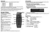
...5000 Series RF Remote is for best results. It can be pointed directly at your chartplotter has the current software, available at any time to return to open the access cover on your current location as a waypoint. ... • Size: 135 mm H x 50 mm W x 25.7 mm D (5.3" x 2" x 1") • Weight: 77 g (2.7 oz), without battery 101 g (3.6 oz), with the following Garmin chartplotters: • GPSMAP 4008 GPSMAP 5008 • GPSMAP 4012 GPSMAP 5012 • GPSMAP 4208 GPSMAP 5208 • GPSMAP 4212 GPSMAP 5212 The remote is pressed. this allows you...
...5000 Series RF Remote is for best results. It can be pointed directly at your chartplotter has the current software, available at any time to return to open the access cover on your current location as a waypoint. ... • Size: 135 mm H x 50 mm W x 25.7 mm D (5.3" x 2" x 1") • Weight: 77 g (2.7 oz), without battery 101 g (3.6 oz), with the following Garmin chartplotters: • GPSMAP 4008 GPSMAP 5008 • GPSMAP 4012 GPSMAP 5012 • GPSMAP 4208 GPSMAP 5208 • GPSMAP 4212 GPSMAP 5212 The remote is pressed. this allows you...


