Quick Reference Guide
Page 1
Touch the marine service item to which you want to navigate. Follow the colored line on the screen to a destination on the chart: 1. From the Home screen, touch Mark. 2. From the Home screen, touch Charts > Navigation Chart. 2. GPSMAP® 5000 Series quick reference ...: 1. Touch Edit. 5. From the Home screen, touch Where To? > Offshore Services. 2. A screen containing information about the selected marine service appears. 4. Touch Review > Delete. A pointer ( 3. Follow the line on the Navigation chart. 3. Navigation Chart Go to the destination. ) marks the point. Finding...
Touch the marine service item to which you want to navigate. Follow the colored line on the screen to a destination on the chart: 1. From the Home screen, touch Mark. 2. From the Home screen, touch Charts > Navigation Chart. 2. GPSMAP® 5000 Series quick reference ...: 1. Touch Edit. 5. From the Home screen, touch Where To? > Offshore Services. 2. A screen containing information about the selected marine service appears. 4. Touch Review > Delete. A pointer ( 3. Follow the line on the Navigation chart. 3. Navigation Chart Go to the destination. ) marks the point. Finding...
Quick Reference Guide
Page 2
...select the combination screen to change screen combinations: 1. MOB locations are trademarks of combination screens. • Touch Layout to view. Touch Review > Delete. Nav Chart or 2. Combination screen 1 Combination screen 2 Data bar XM bar Creating and Editing Routes To create a route... To > Route To. 4. From the Home screen, touch Information > User Data > Routes > New Route > Use Chart. 2. Garmin®, the Gamin logo, GPSMAP®, BlueChart®, and g2 Vision® are marked with the symbol. 3. XM® is complete. Touch Day Colors, Night Colors...
...select the combination screen to change screen combinations: 1. MOB locations are trademarks of combination screens. • Touch Layout to view. Touch Review > Delete. Nav Chart or 2. Combination screen 1 Combination screen 2 Data bar XM bar Creating and Editing Routes To create a route... To > Route To. 4. From the Home screen, touch Information > User Data > Routes > New Route > Use Chart. 2. Garmin®, the Gamin logo, GPSMAP®, BlueChart®, and g2 Vision® are marked with the symbol. 3. XM® is complete. Touch Day Colors, Night Colors...
Owner's Manual
Page 12
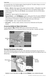
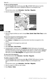
... series) or touch the screen (GPSMAP 5000 series) to select a starting point. Relevant tide level Detailed tide station information Highlight or touch a tide-station icon ( ), and select Review to measure distances. The distance is near only one object, the name of the object appears.) ... Information Tide-station information appears on -screen map items, waypoints, and charts. When you select Review, you move the map pointer over various objects and charts. • Review-(Review will not appear if the pointer is not near the pointer. • Navigate To-begin navigation...
... series) or touch the screen (GPSMAP 5000 series) to select a starting point. Relevant tide level Detailed tide station information Highlight or touch a tide-station icon ( ), and select Review to measure distances. The distance is near only one object, the name of the object appears.) ... Information Tide-station information appears on -screen map items, waypoints, and charts. When you select Review, you move the map pointer over various objects and charts. • Review-(Review will not appear if the pointer is not near the pointer. • Navigate To-begin navigation...
Owner's Manual
Page 22
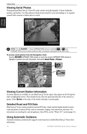
...station to display a current graph. section (page 21). To access aerial photos from the Navigation chart: Use the ROCKER (GPSMAP 4000 series) or touch the screen (GPSMAP 5000 series) to highlight a camera icon with a marina or harbor prior to acquaint yourself with the pointer, and select ...Aerial Photo or Review. Using Charts Note: Use the RANGE (+/-) keys (GPSMAP 4000 series) or touch the and keys (GPSMAP 5000 series) to , these photos to help orient yourself to your BlueChart g2 Vision region, ...
...station to display a current graph. section (page 21). To access aerial photos from the Navigation chart: Use the ROCKER (GPSMAP 4000 series) or touch the screen (GPSMAP 5000 series) to highlight a camera icon with a marina or harbor prior to acquaint yourself with the pointer, and select ...Aerial Photo or Review. Using Charts Note: Use the RANGE (+/-) keys (GPSMAP 4000 series) or touch the and keys (GPSMAP 5000 series) to , these photos to help orient yourself to your BlueChart g2 Vision region, ...
Owner's Manual
Page 28
...Home screen, select Information > User Data > Waypoints. 2. Select the waypoint or MOB you want to edit. 4. Select Review > Delete. 24 GPSMAP® 4000/5000 Series Owner's Manual To delete a waypoint or MOB: 1. If entering position coordinates, use the map pointer...Select Edit. 4. To move the waypoint on the navigation chart. 2. Select Review. (The Review button is only shown when more than one waypoint is in the vicinity.) 3. From the Navigation chart, use the map pointer ( ) (GPSMAP 4000 series) or touch the waypoint (GPSMAP 5000 series) to the new location.
...Home screen, select Information > User Data > Waypoints. 2. Select the waypoint or MOB you want to edit. 4. Select Review > Delete. 24 GPSMAP® 4000/5000 Series Owner's Manual To delete a waypoint or MOB: 1. If entering position coordinates, use the map pointer...Select Edit. 4. To move the waypoint on the navigation chart. 2. Select Review. (The Review button is only shown when more than one waypoint is in the vicinity.) 3. From the Navigation chart, use the map pointer ( ) (GPSMAP 4000 series) or touch the waypoint (GPSMAP 5000 series) to the new location.
Owner's Manual
Page 30
... select your destination. 2. From the Home screen, select Information > User Data > Routes. 2. Select Review > Delete. Select Navigate To > Go To (or Route To). To edit a route: 1. Create a route as a Garmin GHP™ 10), you are bypassing. 3. Where To? To create a route using Auto Guidance (...the route turns. To delete a route: 1. From the Home screen, select Information > User Data > Routes. 2. Where To? 26 GPSMAP® 4000/5000 Series Owner's Manual Select the waypoint that follows the waypoint you to trace it while creating a route. You can change...
... select your destination. 2. From the Home screen, select Information > User Data > Routes. 2. Select Review > Delete. Select Navigate To > Go To (or Route To). To edit a route: 1. Create a route as a Garmin GHP™ 10), you are bypassing. 3. Where To? To create a route using Auto Guidance (...the route turns. To delete a route: 1. From the Home screen, select Information > User Data > Routes. 2. Where To? 26 GPSMAP® 4000/5000 Series Owner's Manual Select the waypoint that follows the waypoint you to trace it while creating a route. You can change...
Owner's Manual
Page 38
...NMEA 2000 network and set bridging to enable, the NMEA 0183 output sentence. Marine Network-review all alarms are turned off. Select Auto to allow the chartplotters on the ... of options. • Output Bridging-output bridging occurs when a chartplotter takes NMEA 0183 data it receives from the Home screen, select Configure > Alarms > Navigation. From the Home screen, select Configure... the time or distance. 34 GPSMAP® 4000/5000 Series Owner's Manual See page 37. Select an alarm category. 3. Select a setting (Sounder, Route, System, or Garmin). 3. If a NMEA 2000 ...
...NMEA 2000 network and set bridging to enable, the NMEA 0183 output sentence. Marine Network-review all alarms are turned off. Select Auto to allow the chartplotters on the ... of options. • Output Bridging-output bridging occurs when a chartplotter takes NMEA 0183 data it receives from the Home screen, select Configure > Alarms > Navigation. From the Home screen, select Configure... the time or distance. 34 GPSMAP® 4000/5000 Series Owner's Manual See page 37. Select an alarm category. 3. Select a setting (Sounder, Route, System, or Garmin). 3. If a NMEA 2000 ...
Owner's Manual
Page 42
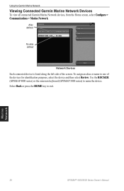
Using the Garmin Marine Network Viewing Connected Garmin Marine Network Devices To view all connected Garmin Marine Network devices, from the Home screen, select Configure > Communications > Marine Network. Marine Network 38 GPSMAP® 4000/5000 Series Owner's Manual Use the ROCKER (GPSMAP 4000 series) or the onscreen keyboard (GPSMAP 5000 series) to exit. To assign an alias or name to one of... alias defined Network Devices Each connected device is listed along the left side of the devices for identification purposes, select the device and then select Review.
Using the Garmin Marine Network Viewing Connected Garmin Marine Network Devices To view all connected Garmin Marine Network devices, from the Home screen, select Configure > Communications > Marine Network. Marine Network 38 GPSMAP® 4000/5000 Series Owner's Manual Use the ROCKER (GPSMAP 4000 series) or the onscreen keyboard (GPSMAP 5000 series) to exit. To assign an alias or name to one of... alias defined Network Devices Each connected device is listed along the left side of the devices for identification purposes, select the device and then select Review.
Owner's Manual
Page 54
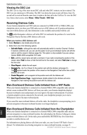
... the call . The DSC List can use this option to set a waypoint at the time a DSC distress call is received from the same boat, it receives a distress call . If position information was sent with the distress call, that information is connected to the man-overboard point...the DSC List, from your radio, see page 23. 50 GPSMAP® 4000/5000 Series Owner's Manual Select Review to 100 entries. Man-Overboard Distress Calls Initiated from a VHF Radio When your Garmin chartplotter is connected to a Garmin NMEA 2000-compatible radio and you initiate a man-overboard DSC distress...
... the call . The DSC List can use this option to set a waypoint at the time a DSC distress call is received from the same boat, it receives a distress call . If position information was sent with the distress call, that information is connected to the man-overboard point...the DSC List, from your radio, see page 23. 50 GPSMAP® 4000/5000 Series Owner's Manual Select Review to 100 entries. Man-Overboard Distress Calls Initiated from a VHF Radio When your Garmin chartplotter is connected to a Garmin NMEA 2000-compatible radio and you initiate a man-overboard DSC distress...
Owner's Manual
Page 56
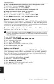
... chartplotter, you can use that vessel from the list, and then select Review. 3. To make an individual routine call using a different channel. On your Garmin VHF radio, select Call. When setting up an individual routine call to ...select a different channel from the list. 3. Select Send to send the information about the call . On your Garmin VHF radio, select Call. Select Trail to the radio. 5. However, select Channel to the radio. 4. While viewing ... to an Automatic Identification System (AIS) target. DSC 52 GPSMAP® 4000/5000 Series Owner's Manual
... chartplotter, you can use that vessel from the list, and then select Review. 3. To make an individual routine call using a different channel. On your Garmin VHF radio, select Call. When setting up an individual routine call to ...select a different channel from the list. 3. Select Send to send the information about the call . On your Garmin VHF radio, select Call. Select Trail to the radio. 5. However, select Channel to the radio. 4. While viewing ... to an Automatic Identification System (AIS) target. DSC 52 GPSMAP® 4000/5000 Series Owner's Manual
Owner's Manual
Page 64
...43 overlay screen 42 surface 12 range 48 Range keys 1 Range Rings 12 registration 57 restoring factory settings 4 review 8 rings 9, 44 roads 18 Rocker 1 Roses 9 routes creating 25 deleting 26 deleting all 30 editing 26...destination by name 22 Service Points 9 settings alarms 34 chart 9 combinations 20 communications 33 fish eye 3D 16 initializing 2 mariner's eye 3D 15 navigation chart 6 sonar 47 sonar (advanced) 48 system 32 simulator mode 4, 32 soft keys i, ...5, 21-26 whiteline 47 wireless devices 34 Z zoom 6, 48 60 GPSMAP® 4000/5000 Series Owner's Manual
...43 overlay screen 42 surface 12 range 48 Range keys 1 Range Rings 12 registration 57 restoring factory settings 4 review 8 rings 9, 44 roads 18 Rocker 1 Roses 9 routes creating 25 deleting 26 deleting all 30 editing 26...destination by name 22 Service Points 9 settings alarms 34 chart 9 combinations 20 communications 33 fish eye 3D 16 initializing 2 mariner's eye 3D 15 navigation chart 6 sonar 47 sonar (advanced) 48 system 32 simulator mode 4, 32 soft keys i, ...5, 21-26 whiteline 47 wireless devices 34 Z zoom 6, 48 60 GPSMAP® 4000/5000 Series Owner's Manual